Alex Boreham
@cyclonicwx.bsky.social
2K followers 74 following 270 posts
Tropical meteorologist, B.S. FSU, amateur web, Python, & GrADS programmer. Also known as Not Sparta
Posts Media Videos Starter Packs
cyclonicwx.bsky.social
Whatever happens though, it is forecast to get uncomfortably close to the northern Leeward Islands and Virgin Islands, so it is worth keeping track of during the next few days
cyclonicwx.bsky.social
If Jerry becomes a hurricane as forecast, it'll be in the vein of Elsa in 2021 where the SW end of the storm was far weaker than the NE because of forward motion.
cyclonicwx.bsky.social
We have #Jerry today in the MDR. There is some shear affecting it, pushing the LLC towards the western end of most of the convection despite an upper anticyclone. It turns out the fast easterly flow near the surface is canceling this out.
cyclonicwx.bsky.social
Seems the Atlantic has read a new book today... #Humberto #Imelda
cyclonicwx.bsky.social
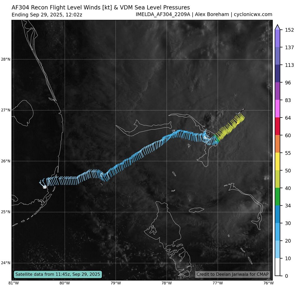
#Imelda has quite the broad wind field, despite the satellite presentation today. Weird storm. Not going to do anything fast with this sort of structure, except maybe become extratropical when it interacts with the next trough
cyclonicwx.bsky.social
Seeing some of those higher winds near #Imelda's center for the first time. May be first signs of a core beginning to form
cyclonicwx.bsky.social
I've just redesigned the recon page, so now you can see all the data in one page! I have also added a few shiny new plots. One consolidates the observations the plane makes all in one image, and the other plots wind for various levels reported by dropsondes. Will be useful with upper level flights!
cyclonicwx.bsky.social
Recon found #Humberto weaker and in the late stages of an ERC. The moat showing up on IR and outer eyewall winds dominant over the inner suggests the inner eyewall is not long for this world. We'll see if it can finish before shear starts to rise tomorrow
cyclonicwx.bsky.social
#Humberto's eye is warming rapidly on water vapor imagery, signifying extreme subsidence in the eye and an upper echelon tropical cyclone. This warmth in the eye is something hard to come by even for Category 4s!
cyclonicwx.bsky.social
The upper trough originally expected to reel #TD9 in is weaker today, making it less likely to landfall in the Carolinas. However, with more ridging around and slower movement, it has inched closer to Florida. There are now tropical storm watches up for some of its east coast
cyclonicwx.bsky.social
#Humberto has a meso sector on it now. As a strong Category 4, it has a nice, cleared out stadium effect eye. You can even see the low level clouds spinning around in the eye! Always love the views like this
cyclonicwx.bsky.social
Either way, #94L's main hazard will be flooding. The upper low in the area bringing some moisture in combined with 94L's approach will set off a possible predecessor rain event. If it slows down/stalls in the area this issue could be compounded. Will need to keep a close eye on steering/track
cyclonicwx.bsky.social
If it gets itself together relatively early it may be able to rapidly intensify from these conditions, similar to other sheared RI cases in the Gulf. Another one of those setups that hinge a lot on the near-term organization
cyclonicwx.bsky.social
#94L has an interesting strength forecast. While moving NNW it will be hit by southerly shear ahead of an upper trough, with some dry air working its way upshear. However, it will traverse very warm waters near the Gulf Stream along with very strong upper divergence.
cyclonicwx.bsky.social
Crazy eye clearing with #Humberto this morning. Looks like shear was less of an issue then thought and we got rapid intensification. Probably closer to major than 75kt
cyclonicwx.bsky.social
Worth keeping an eye on #94L as it enters the Bahamas. Trough interaction will make for a potentially favorable environment there. At the same time a low will cut off in the SE. This plus the ridge building in means potential for it to be pulled into the CONUS
cyclonicwx.bsky.social
Now a Category 4, #Gabrielle's satellite presentation continues to improve. Great time to watch the mesoscale loop as the sun goes down!
cyclonicwx.bsky.social
#Gabrielle has rapidly intensified during the night, clearing out an eye and becoming a major hurricane. Very nice outflow on the western side, showing the jet interaction beginning! This will help it keep intensifying before shear gets too high and the interaction becomes unfavorable
cyclonicwx.bsky.social
It's #Ragasa's turn to put on a show on visible imagery today. Just look at that truck tire eye! Got finished with quite a smooth ERC. It's starting to feel a little shear but not being majorly impacted yet. Will impact the Babuyan islands with its full force soon. Hopefully everyone there is safe!
cyclonicwx.bsky.social
#Gabrielle is getting going now after being ventilated by the ULL nearby, reducing some of the shear/dry air issues. Its pressure has fallen to 994mb, and recon found hurricane strength wind at flight level. Add in some wrapping convection on satellite, and it looks like it will be a hurricane soon
cyclonicwx.bsky.social
#Neoguri seriously intensified last night, and now has a great cleared out stadium effect eye. Great to look at on visible. Almost surely has to be a super typhoon now!
cyclonicwx.bsky.social
A well-organized storm in the Atlantic not named Erin?? #Gabrielle is fairly well put together today with recon going in and finding a relatively well aligned #Gabrielle with pressures having fallen to around 1000mb. Notable that the LLC is quite tight so it has potential to ramp up quick
cyclonicwx.bsky.social
#Ragasa is wrapping powerful convection around its eye. Not quite stable yet as usual for this step of development. A little subtle shear it seems but has the potential to be a pretty strong category 4 soon and stabilize the wrapping hot towers
cyclonicwx.bsky.social
The West Pacific has come alive with 2 active typhoons. Embedded in favorable conditions, both should intensify to 100kt+, having formed inner cores and clearing eyes. Areas from Northern Luzon to Taiwan will need to watch for a stronger #Ragasa while #Neoguri is not a major land threat for now
cyclonicwx.bsky.social
#Gabrielle is the platonic ideal of a tropical cyclone. Can't imagine how it could get any better looking