


Dan Holley
@danholley.bsky.social
Met Office Deputy Chief Meteorologist @metoffice.gov.uk ⛅
Weather Images Editor, RMetS journal "Weather" https://www.rmets.org/weather 📖
Research: http://tinyurl.com/wxresearch 📈
Storm Chaser 🌩🏃
Own views
Weather Images Editor, RMetS journal "Weather" https://www.rmets.org/weather 📖
Research: http://tinyurl.com/wxresearch 📈
Storm Chaser 🌩🏃
Own views
In the HadUKP series for the "NW England and north Wales" region, Saturday 20th September 2025 was the 7th wettest day in the whole dataset back to 1931.
For a two-day event, Friday 19th/Saturday 20th falls to 12th place, but is the wettest two-day period since Christmas Day/Boxing Day 2015.
For a two-day event, Friday 19th/Saturday 20th falls to 12th place, but is the wettest two-day period since Christmas Day/Boxing Day 2015.

September 22, 2025 at 1:01 PM
In the HadUKP series for the "NW England and north Wales" region, Saturday 20th September 2025 was the 7th wettest day in the whole dataset back to 1931.
For a two-day event, Friday 19th/Saturday 20th falls to 12th place, but is the wettest two-day period since Christmas Day/Boxing Day 2015.
For a two-day event, Friday 19th/Saturday 20th falls to 12th place, but is the wettest two-day period since Christmas Day/Boxing Day 2015.
Across a swathe of Wales and N'ern England, Sat 20th Sept was the wettest climatological day (09Z - 09Z) since at least New Year's Eve 2024.
Loftus (N Yorks) recorded its wettest day, for any month, since Aug 2002; Trawsgoed (Ceredigion) wettest day since Oct 2018.
Data @roostweather.bsky.social
Loftus (N Yorks) recorded its wettest day, for any month, since Aug 2002; Trawsgoed (Ceredigion) wettest day since Oct 2018.
Data @roostweather.bsky.social

September 21, 2025 at 1:29 PM
Across a swathe of Wales and N'ern England, Sat 20th Sept was the wettest climatological day (09Z - 09Z) since at least New Year's Eve 2024.
Loftus (N Yorks) recorded its wettest day, for any month, since Aug 2002; Trawsgoed (Ceredigion) wettest day since Oct 2018.
Data @roostweather.bsky.social
Loftus (N Yorks) recorded its wettest day, for any month, since Aug 2002; Trawsgoed (Ceredigion) wettest day since Oct 2018.
Data @roostweather.bsky.social
Very energetic thunderstorms in eastern Scotland this afternoon, producing hail ≥3 cm in diameter and torrential rain — some unofficial gauges recorded as much as 50 mm in 15-25 minutes. The temperature at Aboyne fell by 11°C over a 24 minute period ⛈️


August 14, 2025 at 6:29 PM
Very energetic thunderstorms in eastern Scotland this afternoon, producing hail ≥3 cm in diameter and torrential rain — some unofficial gauges recorded as much as 50 mm in 15-25 minutes. The temperature at Aboyne fell by 11°C over a 24 minute period ⛈️
Storm #Floris, an exceptional summer storm 🌀
Provisionally:
- Strongest August gust on record in Scotland
- Equal strongest August gust on record in Northern Ireland
- Lowest August mean sea level pressure in NW Scotland and Orkney since 1992
- Central pressure ⬇️ 28 hPa in 24 hours
Provisionally:
- Strongest August gust on record in Scotland
- Equal strongest August gust on record in Northern Ireland
- Lowest August mean sea level pressure in NW Scotland and Orkney since 1992
- Central pressure ⬇️ 28 hPa in 24 hours
August 4, 2025 at 7:50 PM
Storm #Floris, an exceptional summer storm 🌀
Provisionally:
- Strongest August gust on record in Scotland
- Equal strongest August gust on record in Northern Ireland
- Lowest August mean sea level pressure in NW Scotland and Orkney since 1992
- Central pressure ⬇️ 28 hPa in 24 hours
Provisionally:
- Strongest August gust on record in Scotland
- Equal strongest August gust on record in Northern Ireland
- Lowest August mean sea level pressure in NW Scotland and Orkney since 1992
- Central pressure ⬇️ 28 hPa in 24 hours
Decent noctilucent cloud display from Devon (50.7°N) late Sunday evening ✨

June 29, 2025 at 11:02 PM
Decent noctilucent cloud display from Devon (50.7°N) late Sunday evening ✨
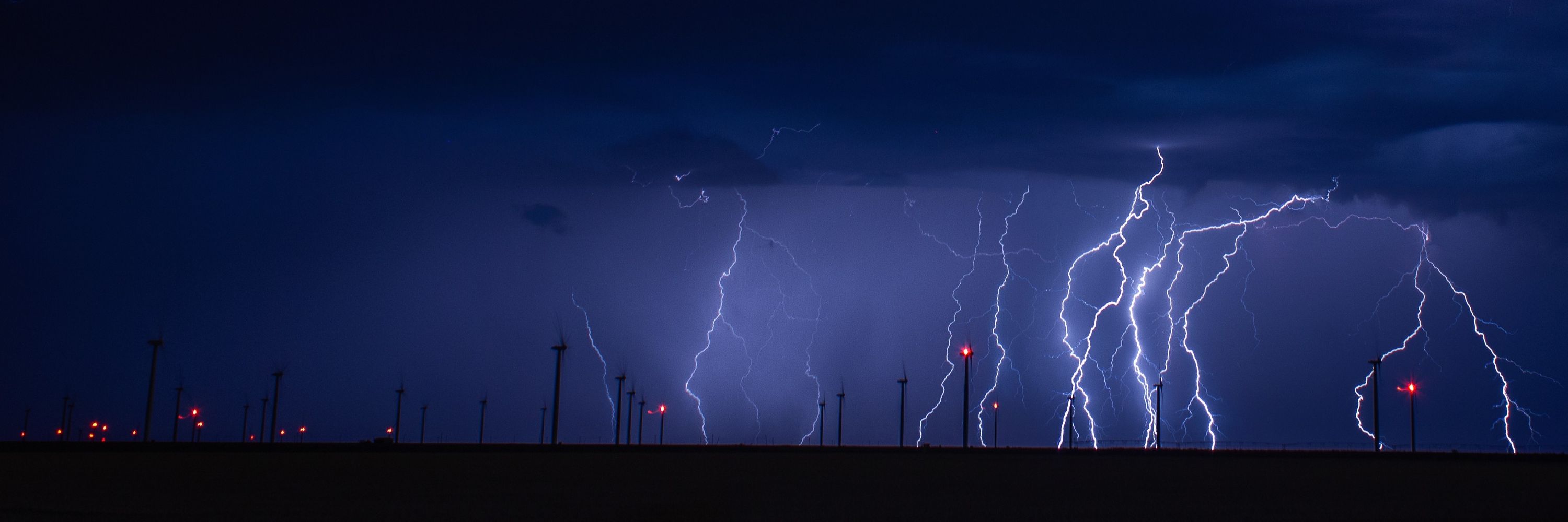
Lightning under moonlight, west of Channing TX on Saturday evening ⚡🌚

June 8, 2025 at 6:13 PM
Lightning under moonlight, west of Channing TX on Saturday evening ⚡🌚
Incredible supercell structure near Amistad NM on Saturday evening 🌩️

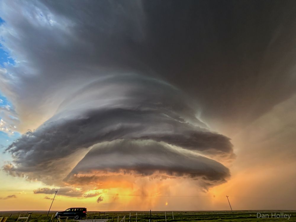
June 8, 2025 at 7:14 AM
Incredible supercell structure near Amistad NM on Saturday evening 🌩️
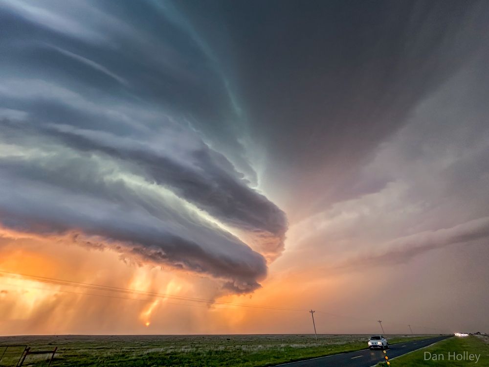
An hour earlier, the same supercell thunderstorm moved through Gruver TX, with the tornado sirens blaring across town as Emergency Alerts ring on our mobile phones
June 7, 2025 at 4:12 PM
An hour earlier, the same supercell thunderstorm moved through Gruver TX, with the tornado sirens blaring across town as Emergency Alerts ring on our mobile phones
Lightning over Spearman TX on Friday evening, shortly after a tornadic supercell thunderstorm moved through town
June 7, 2025 at 4:05 PM
Lightning over Spearman TX on Friday evening, shortly after a tornadic supercell thunderstorm moved through town
Genuinely lost count how many tornadoes were produced by this supercell thunderstorm that trundled ESE'wards from near Dora NM to Lubbock TX on Thursday afternoon/evening 🌪️

June 6, 2025 at 5:43 AM
Genuinely lost count how many tornadoes were produced by this supercell thunderstorm that trundled ESE'wards from near Dora NM to Lubbock TX on Thursday afternoon/evening 🌪️
March 2025 was noteworthy for abundant sunshine and lack of rain — provisionally, it was the sunniest March on record in England, sunnier than July or August last year or the year before! ☀️
Wales (provisionally) had its driest March since 1944 & lowest number of March rain days (1 mm) since 1929. 🏜️
Wales (provisionally) had its driest March since 1944 & lowest number of March rain days (1 mm) since 1929. 🏜️

April 1, 2025 at 1:02 PM
March 2025 was noteworthy for abundant sunshine and lack of rain — provisionally, it was the sunniest March on record in England, sunnier than July or August last year or the year before! ☀️
Wales (provisionally) had its driest March since 1944 & lowest number of March rain days (1 mm) since 1929. 🏜️
Wales (provisionally) had its driest March since 1944 & lowest number of March rain days (1 mm) since 1929. 🏜️

An incredible satellite sequence from GOES-East over the US Plains on Friday evening. Severe thunderstorms erupting along the cold front, intense winds (60-80 mph) to its rear suspending vast quantities of dust (area covered is larger than the UK), and a significant number of wildfires (black spots)
March 15, 2025 at 8:37 AM
An incredible satellite sequence from GOES-East over the US Plains on Friday evening. Severe thunderstorms erupting along the cold front, intense winds (60-80 mph) to its rear suspending vast quantities of dust (area covered is larger than the UK), and a significant number of wildfires (black spots)
Recent anticyclonic conditions has allowed many parts of England and Wales their sunniest start to March on record. Wattisham has already received ~50% of its monthly average sunshine in just 6 days.
In stark contrast, Tiree has recorded its dullest start to March on record (data back to 1931).
In stark contrast, Tiree has recorded its dullest start to March on record (data back to 1931).


March 7, 2025 at 9:40 AM
Recent anticyclonic conditions has allowed many parts of England and Wales their sunniest start to March on record. Wattisham has already received ~50% of its monthly average sunshine in just 6 days.
In stark contrast, Tiree has recorded its dullest start to March on record (data back to 1931).
In stark contrast, Tiree has recorded its dullest start to March on record (data back to 1931).
105mm of rain fell at Nant Yr Ysfa (Rhondda Cynon Taf), 103mm at White Barrow (Devon), 06Z Sunday to 06Z Monday.
Met Office warnings mentioned 80-100mm exposed hills in S. Wales, and 70-100mm Dartmoor.
Accum rates similar to Storm Bert, but Bert lasted ~43 hours.
Map: @roostweather.bsky.social
Met Office warnings mentioned 80-100mm exposed hills in S. Wales, and 70-100mm Dartmoor.
Accum rates similar to Storm Bert, but Bert lasted ~43 hours.
Map: @roostweather.bsky.social

February 24, 2025 at 11:37 AM
105mm of rain fell at Nant Yr Ysfa (Rhondda Cynon Taf), 103mm at White Barrow (Devon), 06Z Sunday to 06Z Monday.
Met Office warnings mentioned 80-100mm exposed hills in S. Wales, and 70-100mm Dartmoor.
Accum rates similar to Storm Bert, but Bert lasted ~43 hours.
Map: @roostweather.bsky.social
Met Office warnings mentioned 80-100mm exposed hills in S. Wales, and 70-100mm Dartmoor.
Accum rates similar to Storm Bert, but Bert lasted ~43 hours.
Map: @roostweather.bsky.social
A few unofficial snow depth reports submitted to the WeatherQuest snow depth tool (weatherquest.co.uk/snowdepth/map) suggest as much as 38-40 cm across the north Pennines

January 6, 2025 at 12:01 PM
A few unofficial snow depth reports submitted to the WeatherQuest snow depth tool (weatherquest.co.uk/snowdepth/map) suggest as much as 38-40 cm across the north Pennines
Some places experienced freezing rain on Sunday — especially Wales and the Midlands, as confirmed by these BBC Weather Watchers photos.
The deepest official snow depth reported was 24 cm at Copley (Co Durham) at 9am on Monday morning — but parts of the northern Pennines likely saw more than this.
The deepest official snow depth reported was 24 cm at Copley (Co Durham) at 9am on Monday morning — but parts of the northern Pennines likely saw more than this.

January 6, 2025 at 10:09 AM
Some places experienced freezing rain on Sunday — especially Wales and the Midlands, as confirmed by these BBC Weather Watchers photos.
The deepest official snow depth reported was 24 cm at Copley (Co Durham) at 9am on Monday morning — but parts of the northern Pennines likely saw more than this.
The deepest official snow depth reported was 24 cm at Copley (Co Durham) at 9am on Monday morning — but parts of the northern Pennines likely saw more than this.
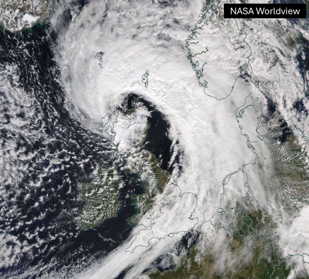
A look back at a few weather snaps 📸 from 2024 — the highlight of the year has to be the total solar #eclipse in April, but closely followed by the most amazing #aurora display in May (made even more special by being visible, by eye 👀, at 52.5°N)...
What does 2025 have in store? 🤔
What does 2025 have in store? 🤔

December 31, 2024 at 2:43 PM
Here's a look at all named storms that have impacted the UK since official naming began in 2015, including some named by other forecasting centres, coloured by the highest warning level issued.
The storm season runs each year from September through to the end of August the following year.
The storm season runs each year from September through to the end of August the following year.

December 9, 2024 at 4:30 PM
Here's a look at all named storms that have impacted the UK since official naming began in 2015, including some named by other forecasting centres, coloured by the highest warning level issued.
The storm season runs each year from September through to the end of August the following year.
The storm season runs each year from September through to the end of August the following year.