


Dan Goldberg, PhD
@dgoldbergaq.bsky.social
George Washington University Assistant Research Professor. Posting about air quality, remote sensing, climate change, and health
New 📄! We inter-compare satellite-based NASA TEMPO column NO2 with ground monitor surface NO2. Correlation is very good; best in the mid-AM and worst in the late-PM. The work highlights when and where satellite data best represents surface air quality. agupubs.onlinelibrary.wiley.com/doi/10.1029/...

October 21, 2025 at 4:37 PM
New 📄! We inter-compare satellite-based NASA TEMPO column NO2 with ground monitor surface NO2. Correlation is very good; best in the mid-AM and worst in the late-PM. The work highlights when and where satellite data best represents surface air quality. agupubs.onlinelibrary.wiley.com/doi/10.1029/...
Found this somewhat positive news: Maryland & DC have 50% less CO2 emissions than 20 years ago (www.eia.gov/todayinenerg...) A portion of this decrease is because coal plants closed in-state and out-of-state coal plants took some of the load. Nonetheless, don't lose sight of the progress we've made!

October 9, 2025 at 4:32 PM
Found this somewhat positive news: Maryland & DC have 50% less CO2 emissions than 20 years ago (www.eia.gov/todayinenerg...) A portion of this decrease is because coal plants closed in-state and out-of-state coal plants took some of the load. Nonetheless, don't lose sight of the progress we've made!
Almost 2 years of TEMPO NO2 data now available. NO2 air pollution cannot hide!
While this NO2 map looks 🤩, NO2 pollution declines have stagnated over the past 10 years or so. The plot should be more blue by now...
While this NO2 map looks 🤩, NO2 pollution declines have stagnated over the past 10 years or so. The plot should be more blue by now...

July 3, 2025 at 4:44 PM
Almost 2 years of TEMPO NO2 data now available. NO2 air pollution cannot hide!
While this NO2 map looks 🤩, NO2 pollution declines have stagnated over the past 10 years or so. The plot should be more blue by now...
While this NO2 map looks 🤩, NO2 pollution declines have stagnated over the past 10 years or so. The plot should be more blue by now...
Sentinel 4 and GOSAT-GW have been successfully launched! New air pollution and climate measurements coming soon led by EU and Japan respectively
Sentinel 4: NO2, HCHO, etc. every hr over Europe
GOSAT-GW: NO2 & CO2 globally
spaceflightnow.com/2025/07/01/l...
www.nasaspaceflight.com/2025/06/gosa...
Sentinel 4: NO2, HCHO, etc. every hr over Europe
GOSAT-GW: NO2 & CO2 globally
spaceflightnow.com/2025/07/01/l...
www.nasaspaceflight.com/2025/06/gosa...

July 2, 2025 at 12:02 PM
Sentinel 4 and GOSAT-GW have been successfully launched! New air pollution and climate measurements coming soon led by EU and Japan respectively
Sentinel 4: NO2, HCHO, etc. every hr over Europe
GOSAT-GW: NO2 & CO2 globally
spaceflightnow.com/2025/07/01/l...
www.nasaspaceflight.com/2025/06/gosa...
Sentinel 4: NO2, HCHO, etc. every hr over Europe
GOSAT-GW: NO2 & CO2 globally
spaceflightnow.com/2025/07/01/l...
www.nasaspaceflight.com/2025/06/gosa...
Next exciting satellite to measure air quality and greenhouse gases to launch in less than 2 months, June 24, 2025. GOSAT-GW to be launched by the Japanese (JAXA). Measuring CO2, CH4 and NO2 at the same time 😍 www.nies.go.jp/whatsnew/202...

April 30, 2025 at 1:42 PM
Next exciting satellite to measure air quality and greenhouse gases to launch in less than 2 months, June 24, 2025. GOSAT-GW to be launched by the Japanese (JAXA). Measuring CO2, CH4 and NO2 at the same time 😍 www.nies.go.jp/whatsnew/202...
(I posted this before checking the EPA AQS monitoring network, which of course confirmed my suspicion. >30 ppb NO2 across the region, which is 6x the annual 24-hr WHO guideline for reference).

March 19, 2025 at 1:45 PM
(I posted this before checking the EPA AQS monitoring network, which of course confirmed my suspicion. >30 ppb NO2 across the region, which is 6x the annual 24-hr WHO guideline for reference).
This morning... bright blue skies. Tree buds starting to open. Birds chirping. Cool start but warm in the afternoon.
You step outside and try to smell the fresh air and instead you smell something else...
It's hazardous VOCs and NO2 from cars & trucks. We NEVER should be normalizing this.
You step outside and try to smell the fresh air and instead you smell something else...
It's hazardous VOCs and NO2 from cars & trucks. We NEVER should be normalizing this.

March 19, 2025 at 1:32 PM
This morning... bright blue skies. Tree buds starting to open. Birds chirping. Cool start but warm in the afternoon.
You step outside and try to smell the fresh air and instead you smell something else...
It's hazardous VOCs and NO2 from cars & trucks. We NEVER should be normalizing this.
You step outside and try to smell the fresh air and instead you smell something else...
It's hazardous VOCs and NO2 from cars & trucks. We NEVER should be normalizing this.
Every $1 the US has spent on clean air has yielded $30 in savings due to unnecessary healthcare costs and premature death. #standupforscience #fundscience

March 7, 2025 at 7:46 PM
Every $1 the US has spent on clean air has yielded $30 in savings due to unnecessary healthcare costs and premature death. #standupforscience #fundscience
New 📄 alert! Used TROPOMI satellite data to estimate NO2 monthly concentrations. NO2 is a result of fossil fuel burning (mostly vehicles & homes/buildings in cities) and is linked to asthma development (among other health conditions). Excellent work by Omar Nawaz! pubs.acs.org/doi/10.1021/...

January 22, 2025 at 2:21 PM
New 📄 alert! Used TROPOMI satellite data to estimate NO2 monthly concentrations. NO2 is a result of fossil fuel burning (mostly vehicles & homes/buildings in cities) and is linked to asthma development (among other health conditions). Excellent work by Omar Nawaz! pubs.acs.org/doi/10.1021/...
Nitrogen dioxide (NO2) air pollution from the Palisades fire as observed by NASA TEMPO on Tues Jan 7th 😢 Plume is much larger in magnitude than all fossil-fuel combustion from LA during the same time. Can't even imagine the on-the-ground devastation.
January 9, 2025 at 8:17 PM
Nitrogen dioxide (NO2) air pollution from the Palisades fire as observed by NASA TEMPO on Tues Jan 7th 😢 Plume is much larger in magnitude than all fossil-fuel combustion from LA during the same time. Can't even imagine the on-the-ground devastation.
At #AGU24 next week, I'll be speaking Tues 16:10 in Room 202A about NO2 in the presence of clouds, and Friday 16:00 in Marriott Marquis UDC&Catholic about Policy-relevant NO2 applications (see prior posts for teasers). Many other posters/talks by group members, which you should also attend!

December 6, 2024 at 4:53 PM
At #AGU24 next week, I'll be speaking Tues 16:10 in Room 202A about NO2 in the presence of clouds, and Friday 16:00 in Marriott Marquis UDC&Catholic about Policy-relevant NO2 applications (see prior posts for teasers). Many other posters/talks by group members, which you should also attend!
Looking forward to welcoming #AGU24 attendees to my adopted hometown of DC next week! Here's the NO2 pollution NASA TEMPO observed in DC over the past year. Anything green, yellow, orange, or red is likely above the WHO guideline of 5 ppb for an annual average (1x10^15 molec/cm2 ~ 2 ppb).
December 6, 2024 at 4:41 PM
Looking forward to welcoming #AGU24 attendees to my adopted hometown of DC next week! Here's the NO2 pollution NASA TEMPO observed in DC over the past year. Anything green, yellow, orange, or red is likely above the WHO guideline of 5 ppb for an annual average (1x10^15 molec/cm2 ~ 2 ppb).
In preparation of the AGU mtg in 2 weeks, I've been making some TEMPO NO2 animations using the Beta data. Here's an animation for the most polluted ozone day in the mid-Atlantic last summer (Aug 1, 2024). Also can see wildfires out West and most of the largest cities. I could stare at this all day!
November 27, 2024 at 5:53 PM
In preparation of the AGU mtg in 2 weeks, I've been making some TEMPO NO2 animations using the Beta data. Here's an animation for the most polluted ozone day in the mid-Atlantic last summer (Aug 1, 2024). Also can see wildfires out West and most of the largest cities. I could stare at this all day!
We used satellite data to estimate surface NO2 using simple transforms. Very strong correlation (r2 = 0.77). This can be used to quickly estimate near real time surface NO2 concentrations. agupubs.onlinelibrary.wiley.com/doi/full/10.... Forthcoming paper will use a slightly more detailed method.

November 18, 2024 at 2:25 PM
We used satellite data to estimate surface NO2 using simple transforms. Very strong correlation (r2 = 0.77). This can be used to quickly estimate near real time surface NO2 concentrations. agupubs.onlinelibrary.wiley.com/doi/full/10.... Forthcoming paper will use a slightly more detailed method.
👋 Spinning up my time on here... You'll be getting posts like this one, which shows NO2 pollution as observed by satellite data last year. More posts on air quality, climate, and remote sensing to come!
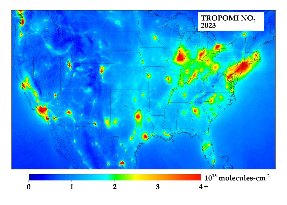
November 14, 2024 at 9:43 PM
👋 Spinning up my time on here... You'll be getting posts like this one, which shows NO2 pollution as observed by satellite data last year. More posts on air quality, climate, and remote sensing to come!