


Dreaming Beetle
@dreamingbeetle.bsky.social
A scientist with an art habit.
DreamingBeetle.redbubble.com
DreamingBeetle.redbubble.com
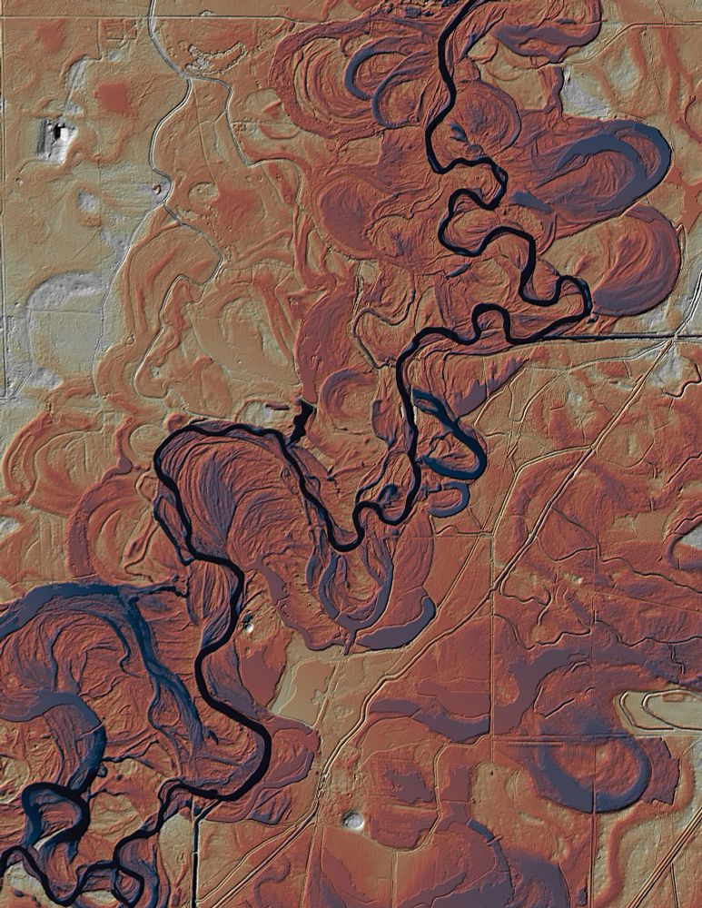
A modified version of Harold Fisk’s Ancient Meanders of the Mississippi River.

December 3, 2025 at 11:16 PM
A modified version of Harold Fisk’s Ancient Meanders of the Mississippi River.
Maps of Manhattan based on 1609 survey data. Originally by Townsend MacCoun, 1909. Modified by Dreaming Beetle LLC. Restoration and playing with color.

December 2, 2025 at 7:50 PM
Maps of Manhattan based on 1609 survey data. Originally by Townsend MacCoun, 1909. Modified by Dreaming Beetle LLC. Restoration and playing with color.
Morning aspirations: cute and poisonous.

September 24, 2025 at 12:57 PM
Morning aspirations: cute and poisonous.
Atlas Beetles


September 3, 2025 at 4:37 PM
Atlas Beetles
Tree bark close ups from Pikes Peak, CO


August 21, 2025 at 2:10 AM
Tree bark close ups from Pikes Peak, CO
A one-off map I made for a friend’s birthday based on the Outlander series.

August 10, 2025 at 1:07 PM
A one-off map I made for a friend’s birthday based on the Outlander series.
A map of school districts recognized by the NAMM Foundation as the 2025 Best Communities for Music Education. #NAMMFOUNDATION #music #eductation #bestcommunities #marchingband #concertband #Maps #GIS
The map was made using data from NAMM and #DOE #NCES data and #ESRI software.
The map was made using data from NAMM and #DOE #NCES data and #ESRI software.

August 6, 2025 at 5:03 PM
A map of school districts recognized by the NAMM Foundation as the 2025 Best Communities for Music Education. #NAMMFOUNDATION #music #eductation #bestcommunities #marchingband #concertband #Maps #GIS
The map was made using data from NAMM and #DOE #NCES data and #ESRI software.
The map was made using data from NAMM and #DOE #NCES data and #ESRI software.
Sedimentary rocks in Garden of the Gods, Colorado Springs, CO.

July 25, 2025 at 6:23 PM
Sedimentary rocks in Garden of the Gods, Colorado Springs, CO.
FL is hosed unless the law is changed.
The ACLU used a map from a Bloomberg article which used a he US coastline (blue dash). CFR 287(a) defines the 100 mile zone from the US External Boundary (I plotted in red). My map shows a smaller area.
www.bloomberg.com/news/article...
The ACLU used a map from a Bloomberg article which used a he US coastline (blue dash). CFR 287(a) defines the 100 mile zone from the US External Boundary (I plotted in red). My map shows a smaller area.
www.bloomberg.com/news/article...

July 22, 2025 at 4:57 AM
FL is hosed unless the law is changed.
The ACLU used a map from a Bloomberg article which used a he US coastline (blue dash). CFR 287(a) defines the 100 mile zone from the US External Boundary (I plotted in red). My map shows a smaller area.
www.bloomberg.com/news/article...
The ACLU used a map from a Bloomberg article which used a he US coastline (blue dash). CFR 287(a) defines the 100 mile zone from the US External Boundary (I plotted in red). My map shows a smaller area.
www.bloomberg.com/news/article...
Enjoying the quiet of the mountains

July 20, 2025 at 1:11 AM
Enjoying the quiet of the mountains
Finding the Rocky Mountains

July 20, 2025 at 1:08 AM
Finding the Rocky Mountains
Issa, demolisher of treats and expert human manipulator

July 14, 2025 at 9:28 PM
Issa, demolisher of treats and expert human manipulator
Making cards for family this week. #papercraft #art

July 12, 2025 at 2:48 AM
Making cards for family this week. #papercraft #art
Ever wondered if you live near an #EPA superfund site? Surprisingly, some of this info is hard to find in your county data. Find details here epa.maps.arcgis.com/apps/mapview...
#gis #environmentalquality #altGov #publicdata
#gis #environmentalquality #altGov #publicdata

June 10, 2025 at 7:35 PM
Ever wondered if you live near an #EPA superfund site? Surprisingly, some of this info is hard to find in your county data. Find details here epa.maps.arcgis.com/apps/mapview...
#gis #environmentalquality #altGov #publicdata
#gis #environmentalquality #altGov #publicdata
A map of relative environmental quality (EQI) as a measure of air, water, land sources of pollution as defined by the #EPA for 2006-2010. Higher pollution on the east and west coast equates with a lower quality environment for those living there. #sciart #gis #altgov #data #science

June 9, 2025 at 10:05 PM


A map showing homes that are part of the Low Income Housing Tax Credit program according to #HUD data. No matter where you live in the US, your friends and neighbors rely on assistance to balance the system. #HousingTaxCredit #LowIncome #costofliving #governmentforthepeoplenotbillionaires

May 15, 2025 at 5:11 PM
A map showing homes that are part of the Low Income Housing Tax Credit program according to #HUD data. No matter where you live in the US, your friends and neighbors rely on assistance to balance the system. #HousingTaxCredit #LowIncome #costofliving #governmentforthepeoplenotbillionaires
A map of #HUD Housing Choice Voucher homes (2024) by census tract. No matter where you live, your neighbors rely on assistance. #Section8 #HousingChoiceVouchers #costofliving #neighbors #governmentforthepeople

May 14, 2025 at 10:45 PM
A map of #HUD Housing Choice Voucher homes (2024) by census tract. No matter where you live, your neighbors rely on assistance. #Section8 #HousingChoiceVouchers #costofliving #neighbors #governmentforthepeople
A scientist with an art habit. I like big data and posting articles and comments that I think are important. I use data from #USGS #NOAA #NASA #CMIP6 #LibraryofCongress #Smithsonian #NIH #NIAID #DOE #GEBCO #Hydrosheds to promote #Science and #SciArt

May 7, 2025 at 6:23 PM
A scientist with an art habit. I like big data and posting articles and comments that I think are important. I use data from #USGS #NOAA #NASA #CMIP6 #LibraryofCongress #Smithsonian #NIH #NIAID #DOE #GEBCO #Hydrosheds to promote #Science and #SciArt
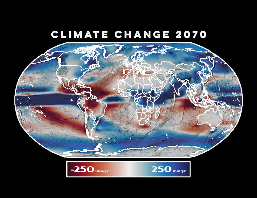
A map of expected changes in rainfall by 2070 in mm/year. #SciArt #GIS #QGIS #CMIP6 #ClimateChange #Climate
DreamingBeetle.redbubble.com
DreamingBeetle.redbubble.com
April 24, 2025 at 7:25 PM
A map of expected changes in rainfall by 2070 in mm/year. #SciArt #GIS #QGIS #CMIP6 #ClimateChange #Climate
DreamingBeetle.redbubble.com
DreamingBeetle.redbubble.com
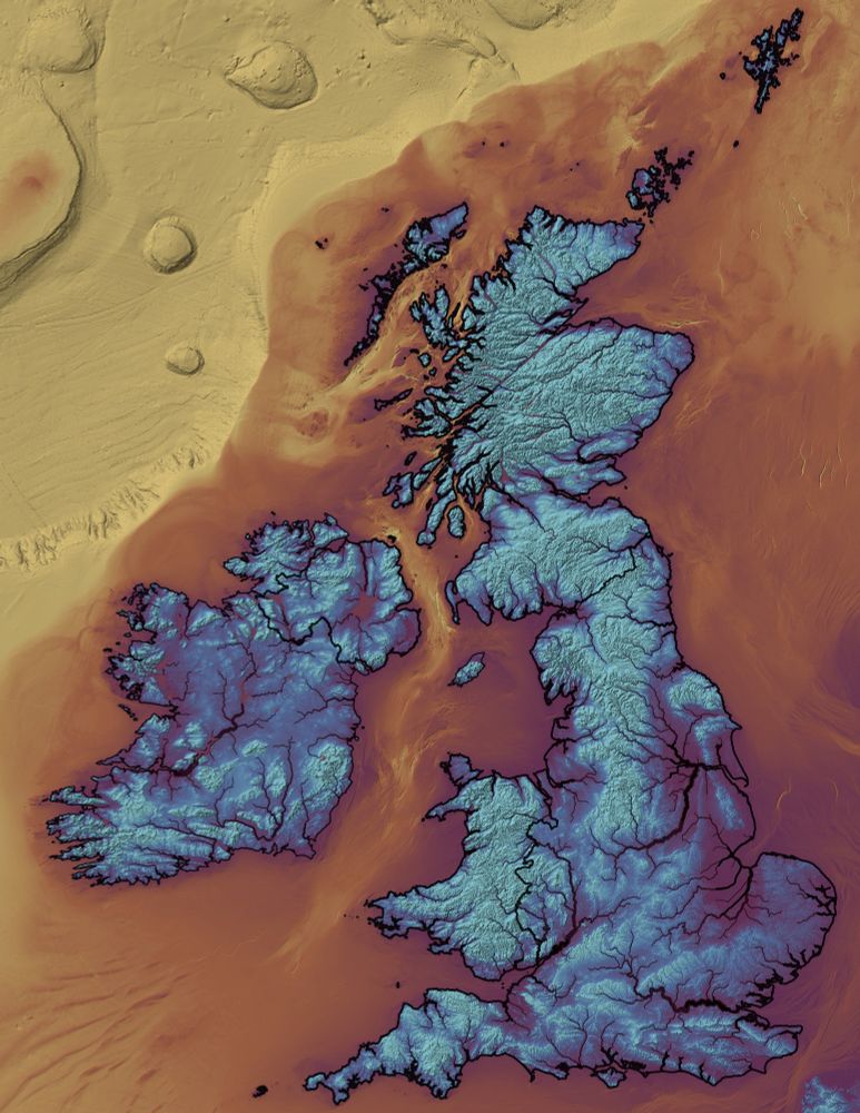
A map of rivers and lakes in the UK and Ireland. #GIS #QGIS #SciArt #geology #rivers #Hydrosheds
DreamingBeetle.redbubble.com
DreamingBeetle.redbubble.com

April 24, 2025 at 6:51 PM
A map of rivers and lakes in the UK and Ireland. #GIS #QGIS #SciArt #geology #rivers #Hydrosheds
DreamingBeetle.redbubble.com
DreamingBeetle.redbubble.com
Global climate models suggest summer temperature increases of 8.5 C (>15 F) by 2070. I rely on access to US government and public data to make these images. #GIS #climatemodels #NOAA #SciArt #Climatechange #GEBCO #CMIP6
DreamingBeetle.redbubble.com
DreamingBeetle.redbubble.com

April 24, 2025 at 1:28 PM
Global climate models suggest summer temperature increases of 8.5 C (>15 F) by 2070. I rely on access to US government and public data to make these images. #GIS #climatemodels #NOAA #SciArt #Climatechange #GEBCO #CMIP6
DreamingBeetle.redbubble.com
DreamingBeetle.redbubble.com
Beautiful metamorphic rocks in Ventana Canyon trail, Tucson AZ

April 20, 2025 at 6:11 PM
Beautiful metamorphic rocks in Ventana Canyon trail, Tucson AZ
Calm under the branches

April 20, 2025 at 6:01 PM
Calm under the branches
#wherelawends #tyranny #protest #resist #elsalvador #noconcentrationcamps #nokings #nooneabovethelaw #constitution #supremecourt #corruption

April 8, 2025 at 10:04 PM