John Ristau 🇨🇦 🇳🇿
@earthquakenz.bsky.social
2.3K followers 530 following 290 posts
Canadian-New Zealand seismologist in New Zealand. Mostly following and posting about earthquakes and seismology-related things, but occasionally other things that interest me.
Posts Media Videos Starter Packs
earthquakenz.bsky.social
Focal mechanisms are typically strike-slip or reverse faulting with WNW-ESE striking P-axes. There are a few places that deviate from this pattern where the P-axes are rotated E-W or NW-SE and are likely associated with favourably oriented crustal faults. 10/
earthquakenz.bsky.social
Historically, there have been four earthquakes with M 6+ in the region, none of them being close to the Alpine Fault. The largest was M 6.7 in 1994 near Arthur’s Pass, the main route between the central west coast and the Canterbury region. A M 6 occurred in 2015 with a similar location. 9/
earthquakenz.bsky.social
In the past 20 years there have been ~950 earthquakes with M 3+, with the largest being M 6 east of the northern section of the Alpine Fault. Along the southern section there could be some earthquakes on the fault; however, it’s difficult to say for certain. 8/
earthquakenz.bsky.social
In the past two years there have been two earthquakes with M 5+ and 12 with M 4+. There is very little seismic activity associated with the Alpine Fault itself; most earthquakes occur east of the fault on other crustal faults. 7/
earthquakenz.bsky.social
This region connects the Hikurangi subduction zone to the north and the Fiordland/Puysegur subduction region to the south; however, with no subduction in this region almost all seismicity is in the crust and shallow. 6/
earthquakenz.bsky.social
The Alpine Fault is divided into several sections: the offshore section, south of Fiordland; the onshore southern and central sections which run along the base of the Southern Alps; and the northern section which splays into the Marlborough fault zone. 5/
earthquakenz.bsky.social
The Alpine Fault is estimated to have a 75% probability of rupturing in a major earthquake in the next 50 years, with an 80% probability it will be M 8+. 4/
earthquakenz.bsky.social
The Alpine Fault is New Zealand’s longest and fastest-slipping strike-slip fault and one of New Zealand’s greatest seismic hazards. It ruptures in M 8+ earthquakes on average every 330 years with the last one in 1717. 3/
earthquakenz.bsky.social
The Alpine Fault is a > 600 km long fault system that runs along the west coast of the South Island and forms the boundary between the Australian and Pacific plates, with the Australian plate moving NE relative to the Pacific plate. 2/
earthquakenz.bsky.social
The West Coast-Southern Alps region runs along the west coast of the South Island. The Southern Alps is a major mountain range the runs along the west coast between Fiordland to the south and the Marlborough region to the north, with the Alpine Fault running along the western edge. 1/ 🧪
earthquakenz.bsky.social
Emergency earthquake water refreshed and hopefully never to be used! 🧪
Reposted by John Ristau 🇨🇦 🇳🇿
judithgeology.bsky.social
⚒️ 🧪 Another big addition to the remarkable M8.8 earthquake sequence offshore Kamchatka: a M7.8 - the biggest aftershock so far.

With foreshocks, aftershocks, aftershocks of foreshocks, and foreshocks of aftershocks, it's hard to keep these earthquakes straight! Read more about what's going on:
M 7.8 strikes offshore Kamchatka
Another big addition to a remarkable earthquake sequence
earthquakeinsights.substack.com
earthquakenz.bsky.social
It changed the way GeoNet operated to provide improved services to the government, emergency responders, and the public. The next major change would be a result of the 2016 M 7.8 Kaikōura earthquake and the start of the National Geohazards Monitoring Centre (NGMC). 12/
earthquakenz.bsky.social
Following the Canterbury earthquakes GeoNet began ‘GeoNet Rapid’, a modernised earthquake analysis system with improved automatic solutions. Automatic solutions were released to the website within a few minutes of an earthquake providing rapid information. 11/
earthquakenz.bsky.social
At the time of the Canterbury earthquakes, when an earthquake happened it was manually reviewed by the duty officer or an analyst before it was released to the GeoNet website. The Canterbury earthquakes put GeoNet in the national spotlight and there was a push for rapid earthquake analysis. 10/
earthquakenz.bsky.social
The Darfield earthquake was a seminal earthquake in recent New Zealand history. It was the most impactful M 7+ earthquake in the country since the 1968 M 7.1 Inangahua earthquake and served as a wake-up call that major earthquakes occur near populated regions in New Zealand. 9/
earthquakenz.bsky.social
The most significant aftershocks were a cluster that occurred near the Christchurch city centre on Boxing Day 2010. These were damaging to brick and masonry structures and widely felt across the city. 8/
earthquakenz.bsky.social
Following the earthquake nearly 4300 aftershocks were recorded in the region over 5 ½ months, the largest being M 5.8, 19 with M 5+, and 145 M 4-5. The larger aftershocks were a mixture of strike-slip and reverse faulting mechanisms. 7/
earthquakenz.bsky.social
It began as a reverse faulting earthquake north of the Greendale Fault, then triggered the Greendale Fault which then triggered faults at the western and eastern ends. Up to 7 faults may have ruptured during the earthquake over ~20 seconds. 6/
earthquakenz.bsky.social
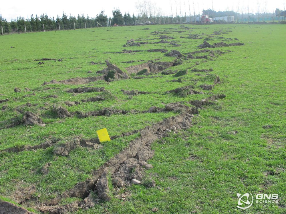
The earthquake ruptured the ~30 km long Greendale Fault which was buried and unmapped before the earthquake. The maximum slip was ~5 m horizontally and 1.5 m vertically. However, the earthquake was more complicated than a simple strike-slip earthquake. 5/
Surface rupture of the Greendale Fault in a field showing offset. Surface rupture of the Greendale Fault. Road offset by several metres as a result of Greendale Fault rupture during the Darfield earthquake.
earthquakenz.bsky.social
Before the earthquake the Canterbury Plains had a low level of seismic activity compared with many other parts of New Zealand. Comparing the number of earthquakes and magnitude over time before and after there were few earthquakes prior to Darfield in the region. 4/
earthquakenz.bsky.social
This thread focusses on the Darfield earthquake and first 5 ½ months of the aftershock sequence up to the February 2011 Christchurch earthquake. I can make a separate thread on the Christchurch earthquake in February. 3/
earthquakenz.bsky.social
Through a fortunate combination of strict building codes and the earthquake occurring at night when the streets were largely deserted, there were no deaths and only two serious injuries. It was the country’s most damaging earthquake since 1931 Hawkes Bay (Mw 7.4-7.6). 2/
earthquakenz.bsky.social
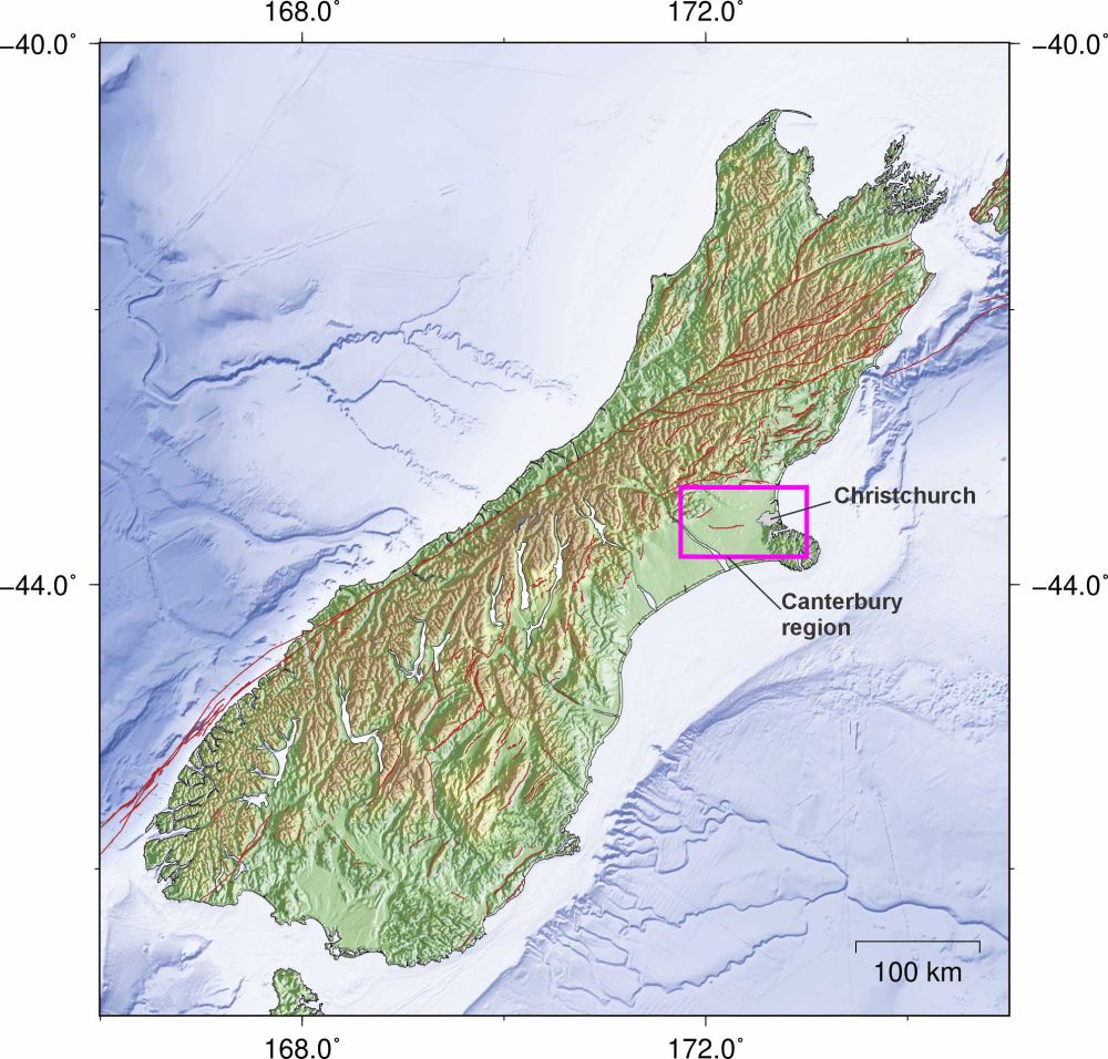
15 years ago, 4 Sep 2010 at 04:35 NZST the Mw 7.1 Darfield earthquake struck the Canterbury region of New Zealand, ~10 km SE of the town of Darfield and 40 km west of Christchurch, New Zealand’s 2nd largest city. It caused significant damage with intensity up to MM 9. 1/ 🧪
Reposted by John Ristau 🇨🇦 🇳🇿
earthjay.bsky.social
A Mini Cascadia Quake? What the 6.5-Magnitude Earthquake of 1954 Reveals About the ‘Big One’

[possibly not on cascadia but maybe]

lostcoastoutpost.com/2025/aug/27/...
A Mini Cascadia Quake? What the 6.5-Magnitude Earthquake of 1954 Reveals About the ‘Big One’
lostcoastoutpost.com