


Eric Wilhelm
@ericwfmj.bsky.social
Chief Meteorologist, WFMJ-TV, Youngstown Ohio.
The Ohio State University
🏌️ ⛈ 🍺 ♟
The Ohio State University
🏌️ ⛈ 🍺 ♟
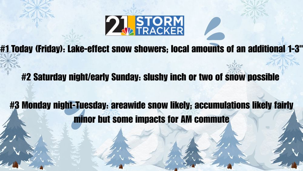
Monday AM Update: No changes to the forecast. Snow is coming and it will be impactful for morning commuters.

December 1, 2025 at 12:43 PM
Monday AM Update: No changes to the forecast. Snow is coming and it will be impactful for morning commuters.
Snow Forecast: 2-4 inches of snow is likely Monday night into Tuesday morning. The highest snowfall rates will probably come between 3am and 8am.


November 30, 2025 at 2:40 PM
Snow Forecast: 2-4 inches of snow is likely Monday night into Tuesday morning. The highest snowfall rates will probably come between 3am and 8am.
Impactful snow is back in the forecast for overnight Mon night and Tues AM. This won't be lake-effect and most places can expect similar conditions: a slower-than-average AM commute. A couple/few inches of snow looks likely; we'll have a forecast map out later this morning.

November 30, 2025 at 1:42 PM
Impactful snow is back in the forecast for overnight Mon night and Tues AM. This won't be lake-effect and most places can expect similar conditions: a slower-than-average AM commute. A couple/few inches of snow looks likely; we'll have a forecast map out later this morning.
Saturday: A real mess in the Midwest today. Locally, a coating to an inch or two is snow is likely tonight....not a big deal for most.
November 29, 2025 at 1:07 PM
Saturday: A real mess in the Midwest today. Locally, a coating to an inch or two is snow is likely tonight....not a big deal for most.
Up to a couple of inches of new snow across the area Saturday night. Many will sleep through it and snow is probably going to change to rain before ending Sunday morning.

November 28, 2025 at 10:32 PM
Up to a couple of inches of new snow across the area Saturday night. Many will sleep through it and snow is probably going to change to rain before ending Sunday morning.
Holiday travel in the Midwest Saturday, especially in and around Chicago: woof.

November 28, 2025 at 9:34 PM
Holiday travel in the Midwest Saturday, especially in and around Chicago: woof.
3:57pm radar and conditions along I-80 near Hubbard.


November 28, 2025 at 9:01 PM
3:57pm radar and conditions along I-80 near Hubbard.
11:05am: lake effect band will be aimed at Southington/Champion/Howland and vicinity for a while, resulting in slick conditions and a localized additional accumulation of a handful of inches.

November 28, 2025 at 4:06 PM
11:05am: lake effect band will be aimed at Southington/Champion/Howland and vicinity for a while, resulting in slick conditions and a localized additional accumulation of a handful of inches.
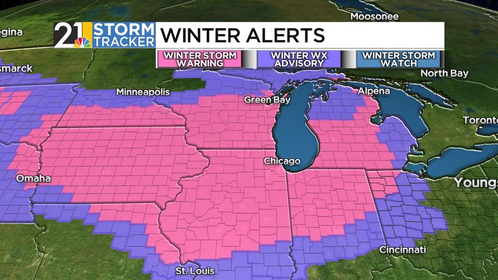
Friday Morning Highlights:
November 28, 2025 at 12:50 PM
Friday Morning Highlights:
Every family has their Thanksgiving traditions. Here we have my brother expertly carving the bird on top of the washing machine, as the pilgrims intended.

November 27, 2025 at 7:04 PM
Every family has their Thanksgiving traditions. Here we have my brother expertly carving the bird on top of the washing machine, as the pilgrims intended.
20 years ago: the snowiest Thanksgiving Day on record. There might be enough snow shower activity late Thursday to get 2025 on this list.

November 27, 2025 at 2:14 AM
20 years ago: the snowiest Thanksgiving Day on record. There might be enough snow shower activity late Thursday to get 2025 on this list.
Latest snow expectations (as of 4pm Wednesday): much of the accumulating lake-effect will come Thursday night into Friday. Looks for changeable conditions and untreated surfaces can be slick.


November 26, 2025 at 8:53 PM
Latest snow expectations (as of 4pm Wednesday): much of the accumulating lake-effect will come Thursday night into Friday. Looks for changeable conditions and untreated surfaces can be slick.
10:10am: some wind gusts of 40mph or so as this skinny line of showers crosses the area.

November 26, 2025 at 3:11 PM
10:10am: some wind gusts of 40mph or so as this skinny line of showers crosses the area.
Wednesday AM: Here comes the cold air. 50s to start, then we'll fall through the 40s and eventually into the 30s by this evening. Midday/afternoon wind gusts up to 40 mph or so.

November 26, 2025 at 12:36 PM
Wednesday AM: Here comes the cold air. 50s to start, then we'll fall through the 40s and eventually into the 30s by this evening. Midday/afternoon wind gusts up to 40 mph or so.
Snow for some, cold and wind for all. Wind chills will be in the teens and 20s Thursday and Friday.

November 26, 2025 at 1:17 AM
Snow for some, cold and wind for all. Wind chills will be in the teens and 20s Thursday and Friday.
Enough snow to make surfaces slick around and north of I-80 at times Wednesday night through Friday. Totals can get up to 6" or so near the Ashtabula/Trumbull line and the Mercer/Crawford line. Much higher totals north of there.

November 25, 2025 at 9:58 PM
Enough snow to make surfaces slick around and north of I-80 at times Wednesday night through Friday. Totals can get up to 6" or so near the Ashtabula/Trumbull line and the Mercer/Crawford line. Much higher totals north of there.
75 years ago right now: the biggest snowstorm in our area's history was ongoing.

November 25, 2025 at 2:17 AM
75 years ago right now: the biggest snowstorm in our area's history was ongoing.
Thanksgiving Travel impacts: minimal in much of the area, but lake-effect snow can lead to slick surfaces in areas north of I-80, mainly late Thursday through Friday morning.

November 25, 2025 at 1:41 AM
Thanksgiving Travel impacts: minimal in much of the area, but lake-effect snow can lead to slick surfaces in areas north of I-80, mainly late Thursday through Friday morning.
22 degree halo this afternoon, from Lenna.

November 24, 2025 at 10:02 PM
22 degree halo this afternoon, from Lenna.
A soggy Tuesday is on the way; the steadiest rain will come before 2pm.

November 24, 2025 at 9:36 PM
A soggy Tuesday is on the way; the steadiest rain will come before 2pm.
Mosquito Lake sunset this evening, from Bill.

November 23, 2025 at 10:26 PM
Mosquito Lake sunset this evening, from Bill.

After the overnight rain, not a bad Saturday with seasonable temperatures.

November 22, 2025 at 2:28 AM
After the overnight rain, not a bad Saturday with seasonable temperatures.
Light rain will impact much of the area later tonight, but we will dry out early Saturday morning.

November 21, 2025 at 9:11 PM
Light rain will impact much of the area later tonight, but we will dry out early Saturday morning.
Like this morning, there might be patches of fog out there Friday morning.

November 20, 2025 at 10:42 PM
Like this morning, there might be patches of fog out there Friday morning.