


GeoLoc Holmes 🌍
@geoloc-holmes.bsky.social
Geo-detective enthusiast, and sometimes I actually find stuff!
🌍
#GEOSINT #GeoLocation #Géolocalisation #OpenSourceIntelligence #OSINT #Imageanalysis #AnalyseDImages #whereisthis
🌍
#GEOSINT #GeoLocation #Géolocalisation #OpenSourceIntelligence #OSINT #Imageanalysis #AnalyseDImages #whereisthis
Pinned

an aerial view of a coastline with a road going through it
ALT: an aerial view of a coastline with a road going through it
media.tenor.com
Hi Bluesky!
Starting this hobby account to solve photo mysteries 🔎🌍📍
I love turning pixels into coordinates, just for this pinpoint thrill that follows hours of this🌀⬇️
If you spot a mystery photo or want help finding a place, tag me or drop a #whereisthis!
#GeoLocation #GEOSINT #OSINT
Starting this hobby account to solve photo mysteries 🔎🌍📍
I love turning pixels into coordinates, just for this pinpoint thrill that follows hours of this🌀⬇️
If you spot a mystery photo or want help finding a place, tag me or drop a #whereisthis!
#GeoLocation #GEOSINT #OSINT
Reposted by GeoLoc Holmes 🌍

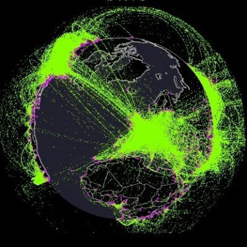
Cette carte des cours d'eau est fabuleuse.
Évidemment, c'est OpenStreetMap derrière, la même base de données qu'il y a derrière @cartes.app
waterwaymap.org
Évidemment, c'est OpenStreetMap derrière, la même base de données qu'il y a derrière @cartes.app
waterwaymap.org
December 23, 2025 at 11:15 AM
Cette carte des cours d'eau est fabuleuse.
Évidemment, c'est OpenStreetMap derrière, la même base de données qu'il y a derrière @cartes.app
waterwaymap.org
Évidemment, c'est OpenStreetMap derrière, la même base de données qu'il y a derrière @cartes.app
waterwaymap.org
Reposted by GeoLoc Holmes 🌍
Rekichizu : une vision moderne des cartes historiques du Japon
cartonumerique.blogspot.com/2025/12/reki...
Les cartes anciennes datent de la fin de la période Edo (1800-1840). Elles peuvent être comparées avec des cartes et des photographies aériennes d'aujourd'hui
cartonumerique.blogspot.com/2025/12/reki...
Les cartes anciennes datent de la fin de la période Edo (1800-1840). Elles peuvent être comparées avec des cartes et des photographies aériennes d'aujourd'hui

December 2, 2025 at 10:39 AM
Rekichizu : une vision moderne des cartes historiques du Japon
cartonumerique.blogspot.com/2025/12/reki...
Les cartes anciennes datent de la fin de la période Edo (1800-1840). Elles peuvent être comparées avec des cartes et des photographies aériennes d'aujourd'hui
cartonumerique.blogspot.com/2025/12/reki...
Les cartes anciennes datent de la fin de la période Edo (1800-1840). Elles peuvent être comparées avec des cartes et des photographies aériennes d'aujourd'hui
Reposted by GeoLoc Holmes 🌍

🛰️ Splendide photo satellite de New-York 🤩 Elle a été prise en inclinant fortement le satellite par rapport à son orbite pour avoir cette perspective inhabituelle mais magnifique !
📸 Vantor (via @rsimmon.bsky.social & @stim3on.bsky.social )
📸 Vantor (via @rsimmon.bsky.social & @stim3on.bsky.social )

November 21, 2025 at 8:57 PM
🛰️ Splendide photo satellite de New-York 🤩 Elle a été prise en inclinant fortement le satellite par rapport à son orbite pour avoir cette perspective inhabituelle mais magnifique !
📸 Vantor (via @rsimmon.bsky.social & @stim3on.bsky.social )
📸 Vantor (via @rsimmon.bsky.social & @stim3on.bsky.social )
Reposted by GeoLoc Holmes 🌍
Ses villages qui font rire de la France profonde

November 19, 2025 at 7:23 PM
Ses villages qui font rire de la France profonde
Reposted by GeoLoc Holmes 🌍

30 ans de COP.
30 ans de négociations climatiques.
La COP 30 commence lundi. Va-t-on enfin voir l’inscription du pétrole, du gaz et du charbon dans le texte final ?
30 ans de négociations climatiques.
La COP 30 commence lundi. Va-t-on enfin voir l’inscription du pétrole, du gaz et du charbon dans le texte final ?

November 8, 2025 at 9:24 AM
30 ans de COP.
30 ans de négociations climatiques.
La COP 30 commence lundi. Va-t-on enfin voir l’inscription du pétrole, du gaz et du charbon dans le texte final ?
30 ans de négociations climatiques.
La COP 30 commence lundi. Va-t-on enfin voir l’inscription du pétrole, du gaz et du charbon dans le texte final ?
Reposted by GeoLoc Holmes 🌍
Ce ne fût pas facile de retrouver l'endroit qui a beaucoup changé et était mal indiqué cartorum (c'est mnt corrigé!)
L'étang est asséché depuis, mais on retrouve le relief et le Wasenbourg sur les hauteurs. D'autres images de ce lieu m'ont aussi aidé à retrouver l'emplacement (48.95707, 7.63047)
L'étang est asséché depuis, mais on retrouve le relief et le Wasenbourg sur les hauteurs. D'autres images de ce lieu m'ont aussi aidé à retrouver l'emplacement (48.95707, 7.63047)


October 10, 2025 at 10:16 AM
Ce ne fût pas facile de retrouver l'endroit qui a beaucoup changé et était mal indiqué cartorum (c'est mnt corrigé!)
L'étang est asséché depuis, mais on retrouve le relief et le Wasenbourg sur les hauteurs. D'autres images de ce lieu m'ont aussi aidé à retrouver l'emplacement (48.95707, 7.63047)
L'étang est asséché depuis, mais on retrouve le relief et le Wasenbourg sur les hauteurs. D'autres images de ce lieu m'ont aussi aidé à retrouver l'emplacement (48.95707, 7.63047)
Reposted by GeoLoc Holmes 🌍
Hello :)
1. The green signs and blue paint on parking lot points for California.
2. A Rail Crossing signs helps to reduce the search to where the main routes (blue) and railtrack (yellow) cross each other.
Result: the Kelso Depot visitor center, in the Mojave Nat'l Preserve.
35.01267, -115.65215
1. The green signs and blue paint on parking lot points for California.
2. A Rail Crossing signs helps to reduce the search to where the main routes (blue) and railtrack (yellow) cross each other.
Result: the Kelso Depot visitor center, in the Mojave Nat'l Preserve.
35.01267, -115.65215


October 11, 2025 at 2:19 PM
Hello :)
1. The green signs and blue paint on parking lot points for California.
2. A Rail Crossing signs helps to reduce the search to where the main routes (blue) and railtrack (yellow) cross each other.
Result: the Kelso Depot visitor center, in the Mojave Nat'l Preserve.
35.01267, -115.65215
1. The green signs and blue paint on parking lot points for California.
2. A Rail Crossing signs helps to reduce the search to where the main routes (blue) and railtrack (yellow) cross each other.
Result: the Kelso Depot visitor center, in the Mojave Nat'l Preserve.
35.01267, -115.65215
Hi Bluesky!
Starting this hobby account to solve photo mysteries 🔎🌍📍
I love turning pixels into coordinates, just for this pinpoint thrill that follows hours of this🌀⬇️
If you spot a mystery photo or want help finding a place, tag me or drop a #whereisthis!
#GeoLocation #GEOSINT #OSINT
Starting this hobby account to solve photo mysteries 🔎🌍📍
I love turning pixels into coordinates, just for this pinpoint thrill that follows hours of this🌀⬇️
If you spot a mystery photo or want help finding a place, tag me or drop a #whereisthis!
#GeoLocation #GEOSINT #OSINT
an aerial view of a coastline with a road going through it
ALT: an aerial view of a coastline with a road going through it
media.tenor.com
November 1, 2025 at 11:27 AM
Hi Bluesky!
Starting this hobby account to solve photo mysteries 🔎🌍📍
I love turning pixels into coordinates, just for this pinpoint thrill that follows hours of this🌀⬇️
If you spot a mystery photo or want help finding a place, tag me or drop a #whereisthis!
#GeoLocation #GEOSINT #OSINT
Starting this hobby account to solve photo mysteries 🔎🌍📍
I love turning pixels into coordinates, just for this pinpoint thrill that follows hours of this🌀⬇️
If you spot a mystery photo or want help finding a place, tag me or drop a #whereisthis!
#GeoLocation #GEOSINT #OSINT