Mojtaba Rajabi
@geostress.bsky.social
270 followers
220 following
4 posts
Senior Lecturer at the University of Queensland & Deputy Head of the World Stress Map Project.
Crustal Stress | Geomechanics | Petrophysics 🌏🌎🌍 Views are my own!
Posts
Media
Videos
Starter Packs
Pinned


Reposted by Mojtaba Rajabi
Reposted by Mojtaba Rajabi


Reposted by Mojtaba Rajabi


Reposted by Mojtaba Rajabi
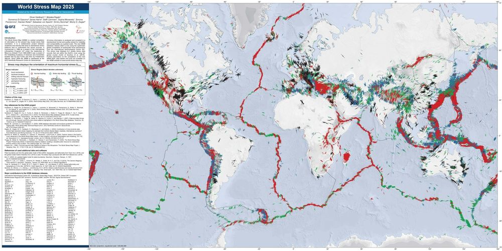
World Stress Map
@wsmproject.bsky.social
· Feb 24

Impact of faults on the remote stress state
Abstract. The impact of faults on the contemporary stress field in the upper crust has been discussed in various studies. Data and models clearly show that there is an effect, but so far, a systematic...
doi.org
Reposted by Mojtaba Rajabi

Karsten Reiter
@karstreit.bsky.social
· Feb 22
Reposted by Mojtaba Rajabi

Reposted by Mojtaba Rajabi

Reposted by Mojtaba Rajabi