


George Steffanos
@gsteffanos.bsky.social
Author of Then the Hail Came, a book about my 1983 Appalachian Trail thru-hike, available on Amazon in both paperback and Kindle.
https://www.georgesteffanos.com
https://www.georgesteffanos.com

🧵4/6
Suddenly, the sky was clearer than it had been in days. I sat down to drink in the sunshine and the views. I was so far ahead of schedule I was able to linger for about an hour. I had a 180-degree view of miles of lowland lake country to the south and mountains to the east and north.
Suddenly, the sky was clearer than it had been in days. I sat down to drink in the sunshine and the views. I was so far ahead of schedule I was able to linger for about an hour. I had a 180-degree view of miles of lowland lake country to the south and mountains to the east and north.

December 15, 2025 at 2:18 PM
🧵4/6
Suddenly, the sky was clearer than it had been in days. I sat down to drink in the sunshine and the views. I was so far ahead of schedule I was able to linger for about an hour. I had a 180-degree view of miles of lowland lake country to the south and mountains to the east and north.
Suddenly, the sky was clearer than it had been in days. I sat down to drink in the sunshine and the views. I was so far ahead of schedule I was able to linger for about an hour. I had a 180-degree view of miles of lowland lake country to the south and mountains to the east and north.
🧵1/6
August 31, 1983: The Appalachian Trail followed some dirt roads through a pleasant farm valley encircled by mountains and reentered the forest to begin a rather taxing climb up to Holts Ledge.
#backpacking #hiking #AppalachianTrail
August 31, 1983: The Appalachian Trail followed some dirt roads through a pleasant farm valley encircled by mountains and reentered the forest to begin a rather taxing climb up to Holts Ledge.
#backpacking #hiking #AppalachianTrail

December 15, 2025 at 2:18 PM
🧵1/6
August 31, 1983: The Appalachian Trail followed some dirt roads through a pleasant farm valley encircled by mountains and reentered the forest to begin a rather taxing climb up to Holts Ledge.
#backpacking #hiking #AppalachianTrail
August 31, 1983: The Appalachian Trail followed some dirt roads through a pleasant farm valley encircled by mountains and reentered the forest to begin a rather taxing climb up to Holts Ledge.
#backpacking #hiking #AppalachianTrail
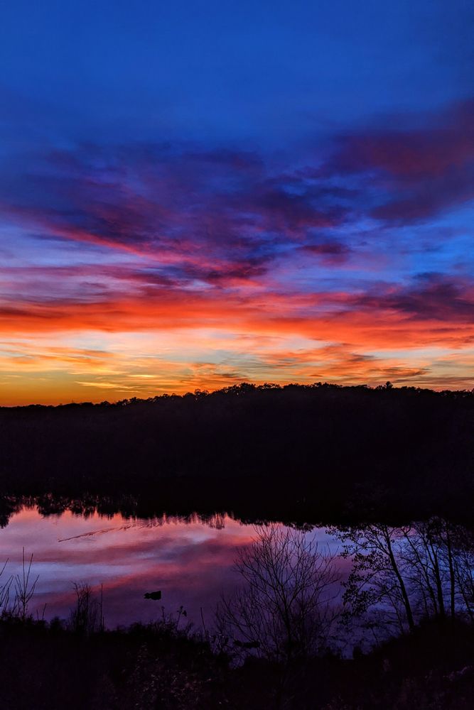
First blush of spring sunset, Lost Ponds, Mattatuck State Forest, Plymouth, Connecticut. April 20, 2021, 7:11 PM.
#sunset #hiking #lake #wildflowers
#sunset #hiking #lake #wildflowers

December 15, 2025 at 12:45 AM
First blush of spring sunset, Lost Ponds, Mattatuck State Forest, Plymouth, Connecticut. April 20, 2021, 7:11 PM.
#sunset #hiking #lake #wildflowers
#sunset #hiking #lake #wildflowers
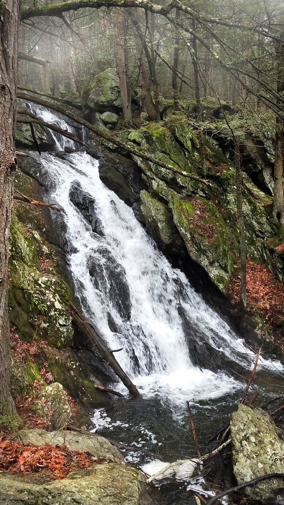
Spring runoff, Buttermilk Falls, Plymouth, Connecticut. April 8, 2019, 5:13 PM.
#hiking #forest #waterfall #stream
#hiking #forest #waterfall #stream
December 14, 2025 at 4:46 PM
Spring runoff, Buttermilk Falls, Plymouth, Connecticut. April 8, 2019, 5:13 PM.
#hiking #forest #waterfall #stream
#hiking #forest #waterfall #stream
🧵1/4
June 8, 1983: The Appalachian Trail joined an old railroad grade known as the Virginia Creeper and followed Whitetop Laurel Creek through the mountains.
#backpacking #hiking #AppalachianTrail
June 8, 1983: The Appalachian Trail joined an old railroad grade known as the Virginia Creeper and followed Whitetop Laurel Creek through the mountains.
#backpacking #hiking #AppalachianTrail

December 14, 2025 at 3:52 PM
🧵1/4
June 8, 1983: The Appalachian Trail joined an old railroad grade known as the Virginia Creeper and followed Whitetop Laurel Creek through the mountains.
#backpacking #hiking #AppalachianTrail
June 8, 1983: The Appalachian Trail joined an old railroad grade known as the Virginia Creeper and followed Whitetop Laurel Creek through the mountains.
#backpacking #hiking #AppalachianTrail

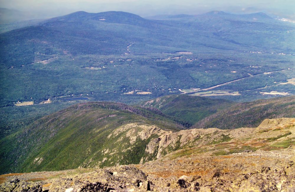
🧵6/7
Above each of these massive cliffs, hawks turned lazy circles in the afternoon sun, while below me others soared over a vast, green farming valley stretched out towards the blurry gray line of the Alleghenies in the misty distance.
Above each of these massive cliffs, hawks turned lazy circles in the afternoon sun, while below me others soared over a vast, green farming valley stretched out towards the blurry gray line of the Alleghenies in the misty distance.
December 13, 2025 at 3:22 PM
🧵6/7
Above each of these massive cliffs, hawks turned lazy circles in the afternoon sun, while below me others soared over a vast, green farming valley stretched out towards the blurry gray line of the Alleghenies in the misty distance.
Above each of these massive cliffs, hawks turned lazy circles in the afternoon sun, while below me others soared over a vast, green farming valley stretched out towards the blurry gray line of the Alleghenies in the misty distance.
🧵5/7
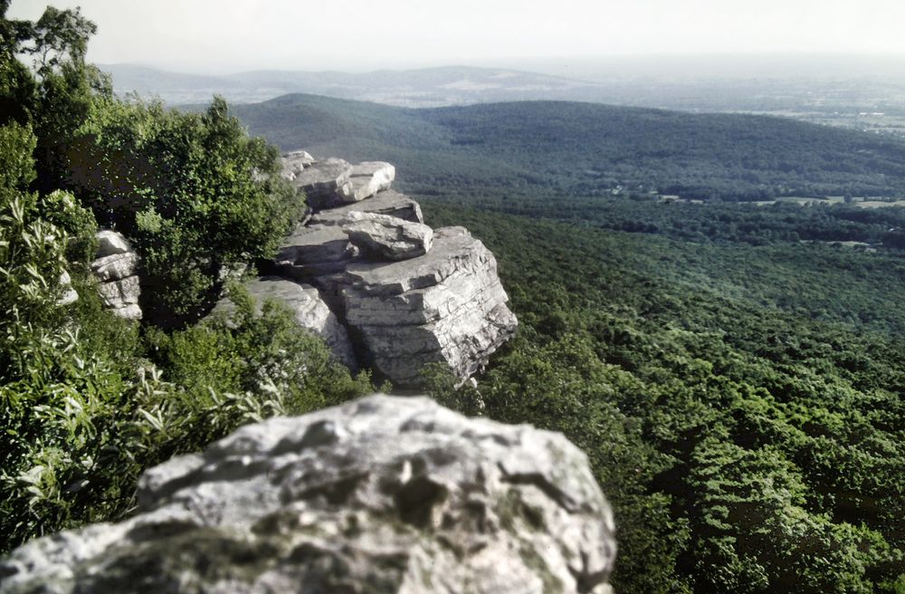
The views from Annapolis Rock and Black Rock along the western rim were the best in Maryland and blew away everything since Hogback Mountain and Mount Marshall in Shenandoah National Park.
The views from Annapolis Rock and Black Rock along the western rim were the best in Maryland and blew away everything since Hogback Mountain and Mount Marshall in Shenandoah National Park.

December 13, 2025 at 3:22 PM
🧵5/7
The views from Annapolis Rock and Black Rock along the western rim were the best in Maryland and blew away everything since Hogback Mountain and Mount Marshall in Shenandoah National Park.
The views from Annapolis Rock and Black Rock along the western rim were the best in Maryland and blew away everything since Hogback Mountain and Mount Marshall in Shenandoah National Park.
🧵4/7
Past the shelter, the arduous ascent continued, now on a badly eroded old woods road covered with rocks.
Once I had reached the ridge crest the footway became much easier, following wide old grassy roads across a broad, flat plateau.
Past the shelter, the arduous ascent continued, now on a badly eroded old woods road covered with rocks.
Once I had reached the ridge crest the footway became much easier, following wide old grassy roads across a broad, flat plateau.

December 13, 2025 at 3:22 PM
🧵4/7
Past the shelter, the arduous ascent continued, now on a badly eroded old woods road covered with rocks.
Once I had reached the ridge crest the footway became much easier, following wide old grassy roads across a broad, flat plateau.
Past the shelter, the arduous ascent continued, now on a badly eroded old woods road covered with rocks.
Once I had reached the ridge crest the footway became much easier, following wide old grassy roads across a broad, flat plateau.
🧵2/7
I could also see this for myself by scanning the elevation profiles on my map.
I stopped at Pine Knob Shelter in order to get water. It was another real dump — filthy, decrepit, and generally falling apart. Chunks were missing from the walls.
I could also see this for myself by scanning the elevation profiles on my map.
I stopped at Pine Knob Shelter in order to get water. It was another real dump — filthy, decrepit, and generally falling apart. Chunks were missing from the walls.

December 13, 2025 at 3:22 PM
🧵2/7
I could also see this for myself by scanning the elevation profiles on my map.
I stopped at Pine Knob Shelter in order to get water. It was another real dump — filthy, decrepit, and generally falling apart. Chunks were missing from the walls.
I could also see this for myself by scanning the elevation profiles on my map.
I stopped at Pine Knob Shelter in order to get water. It was another real dump — filthy, decrepit, and generally falling apart. Chunks were missing from the walls.
🧵1/7
July 13, 1983: On the other side of I-70, the stiff climb up Pine Knob was a harbinger of things to come. I had been told that the AT becomes much more rugged in the northern half of Maryland.
#backpacking #hiking #AppalachianTrail
July 13, 1983: On the other side of I-70, the stiff climb up Pine Knob was a harbinger of things to come. I had been told that the AT becomes much more rugged in the northern half of Maryland.
#backpacking #hiking #AppalachianTrail

December 13, 2025 at 3:22 PM
🧵1/7
July 13, 1983: On the other side of I-70, the stiff climb up Pine Knob was a harbinger of things to come. I had been told that the AT becomes much more rugged in the northern half of Maryland.
#backpacking #hiking #AppalachianTrail
July 13, 1983: On the other side of I-70, the stiff climb up Pine Knob was a harbinger of things to come. I had been told that the AT becomes much more rugged in the northern half of Maryland.
#backpacking #hiking #AppalachianTrail
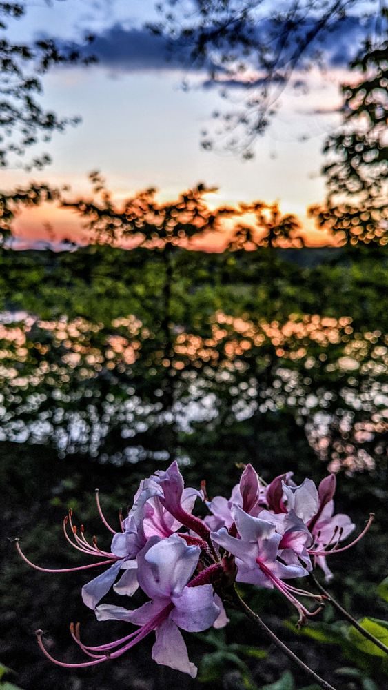
Pink azalea sunset, Scoville Reservoir, Wolcott, Connecticut. May 17, 2021, 8:12 PM.
#sunset #hiking #lake #wildflowers
#sunset #hiking #lake #wildflowers
December 12, 2025 at 6:44 PM
Pink azalea sunset, Scoville Reservoir, Wolcott, Connecticut. May 17, 2021, 8:12 PM.
#sunset #hiking #lake #wildflowers
#sunset #hiking #lake #wildflowers

🧵3/5
Decades later, you could still see traces on the grassy summit of the old fire tower that was removed in the 1950s. There was a dense mass of rhododendron starting to grow up around the lower edges of the views, with a number of treetops along the slopes inching higher,
Decades later, you could still see traces on the grassy summit of the old fire tower that was removed in the 1950s. There was a dense mass of rhododendron starting to grow up around the lower edges of the views, with a number of treetops along the slopes inching higher,

December 12, 2025 at 1:01 PM
🧵3/5
Decades later, you could still see traces on the grassy summit of the old fire tower that was removed in the 1950s. There was a dense mass of rhododendron starting to grow up around the lower edges of the views, with a number of treetops along the slopes inching higher,
Decades later, you could still see traces on the grassy summit of the old fire tower that was removed in the 1950s. There was a dense mass of rhododendron starting to grow up around the lower edges of the views, with a number of treetops along the slopes inching higher,
🧵2/5
More than 5500 feet in height, Standing Indian is by far the highest summit yet for a northbound Appalachian Trail hiker. There would be no higher summits ahead until the Great Smoky Mountains.
More than 5500 feet in height, Standing Indian is by far the highest summit yet for a northbound Appalachian Trail hiker. There would be no higher summits ahead until the Great Smoky Mountains.

December 12, 2025 at 1:01 PM
🧵2/5
More than 5500 feet in height, Standing Indian is by far the highest summit yet for a northbound Appalachian Trail hiker. There would be no higher summits ahead until the Great Smoky Mountains.
More than 5500 feet in height, Standing Indian is by far the highest summit yet for a northbound Appalachian Trail hiker. There would be no higher summits ahead until the Great Smoky Mountains.
🧵1/5
May 10, 1983: The trail up to the top of Standing Indian was so well graded I was able to cover the entire two-mile climb in less than an hour, without stopping for breaks.
#AppalachianTrail #hiking #backpacking
May 10, 1983: The trail up to the top of Standing Indian was so well graded I was able to cover the entire two-mile climb in less than an hour, without stopping for breaks.
#AppalachianTrail #hiking #backpacking

December 12, 2025 at 1:01 PM
🧵1/5
May 10, 1983: The trail up to the top of Standing Indian was so well graded I was able to cover the entire two-mile climb in less than an hour, without stopping for breaks.
#AppalachianTrail #hiking #backpacking
May 10, 1983: The trail up to the top of Standing Indian was so well graded I was able to cover the entire two-mile climb in less than an hour, without stopping for breaks.
#AppalachianTrail #hiking #backpacking

🧵10/10
As I stood there on the summit, I noticed high clouds were moving in fast from the west.
More of My 1983 Appalachian Trail Hike in Photos at www.georgesteffanos.com/places-i-ve-...
As I stood there on the summit, I noticed high clouds were moving in fast from the west.
More of My 1983 Appalachian Trail Hike in Photos at www.georgesteffanos.com/places-i-ve-...
December 11, 2025 at 3:34 PM
🧵10/10
As I stood there on the summit, I noticed high clouds were moving in fast from the west.
More of My 1983 Appalachian Trail Hike in Photos at www.georgesteffanos.com/places-i-ve-...
As I stood there on the summit, I noticed high clouds were moving in fast from the west.
More of My 1983 Appalachian Trail Hike in Photos at www.georgesteffanos.com/places-i-ve-...
🧵9/10
Looking north, the slopes drop precipitously away on all three sides, providing unsurpassed vistas of the Androscoggin River valley and the Wildcat-Carter and Mahoosuc ranges.
Looking north, the slopes drop precipitously away on all three sides, providing unsurpassed vistas of the Androscoggin River valley and the Wildcat-Carter and Mahoosuc ranges.

December 11, 2025 at 3:34 PM
🧵9/10
Looking north, the slopes drop precipitously away on all three sides, providing unsurpassed vistas of the Androscoggin River valley and the Wildcat-Carter and Mahoosuc ranges.
Looking north, the slopes drop precipitously away on all three sides, providing unsurpassed vistas of the Androscoggin River valley and the Wildcat-Carter and Mahoosuc ranges.
🧵8/10
In this col, the Gulfside Trail, which the AT had been following, ended, and the AT followed the Osgood Trail up Mount Madison. At the summit of Madison, the ridge crest of the Presidential Range abruptly comes to an end. Southward are great views of Mounts Washington, Clay, and Adams.
In this col, the Gulfside Trail, which the AT had been following, ended, and the AT followed the Osgood Trail up Mount Madison. At the summit of Madison, the ridge crest of the Presidential Range abruptly comes to an end. Southward are great views of Mounts Washington, Clay, and Adams.

December 11, 2025 at 3:34 PM
🧵8/10
In this col, the Gulfside Trail, which the AT had been following, ended, and the AT followed the Osgood Trail up Mount Madison. At the summit of Madison, the ridge crest of the Presidential Range abruptly comes to an end. Southward are great views of Mounts Washington, Clay, and Adams.
In this col, the Gulfside Trail, which the AT had been following, ended, and the AT followed the Osgood Trail up Mount Madison. At the summit of Madison, the ridge crest of the Presidential Range abruptly comes to an end. Southward are great views of Mounts Washington, Clay, and Adams.
🧵6/10
and All I Got Was This Lousy Minor Summit on My Dad’s Mountain.” Soon, the Airline crossed the Appalachian Trail, and I turned back onto it. Looking back from this point at the impressive sweep of virtually barren rock between Adams and Quincy Adams, you could see why the AT bypassed it.
and All I Got Was This Lousy Minor Summit on My Dad’s Mountain.” Soon, the Airline crossed the Appalachian Trail, and I turned back onto it. Looking back from this point at the impressive sweep of virtually barren rock between Adams and Quincy Adams, you could see why the AT bypassed it.

December 11, 2025 at 3:34 PM
🧵6/10
and All I Got Was This Lousy Minor Summit on My Dad’s Mountain.” Soon, the Airline crossed the Appalachian Trail, and I turned back onto it. Looking back from this point at the impressive sweep of virtually barren rock between Adams and Quincy Adams, you could see why the AT bypassed it.
and All I Got Was This Lousy Minor Summit on My Dad’s Mountain.” Soon, the Airline crossed the Appalachian Trail, and I turned back onto it. Looking back from this point at the impressive sweep of virtually barren rock between Adams and Quincy Adams, you could see why the AT bypassed it.
🧵5/10
From Adams’ summit a trail called the Airline followed the long, barren ridgeline of Adams back down past the rocky knob called Mount Quincy Adams, passing a little to its west. Somewhere John Quincy Adams is wearing a tee shirt that reads, “I Was the Sixth President of the United States
From Adams’ summit a trail called the Airline followed the long, barren ridgeline of Adams back down past the rocky knob called Mount Quincy Adams, passing a little to its west. Somewhere John Quincy Adams is wearing a tee shirt that reads, “I Was the Sixth President of the United States

December 11, 2025 at 3:34 PM
🧵5/10
From Adams’ summit a trail called the Airline followed the long, barren ridgeline of Adams back down past the rocky knob called Mount Quincy Adams, passing a little to its west. Somewhere John Quincy Adams is wearing a tee shirt that reads, “I Was the Sixth President of the United States
From Adams’ summit a trail called the Airline followed the long, barren ridgeline of Adams back down past the rocky knob called Mount Quincy Adams, passing a little to its west. Somewhere John Quincy Adams is wearing a tee shirt that reads, “I Was the Sixth President of the United States
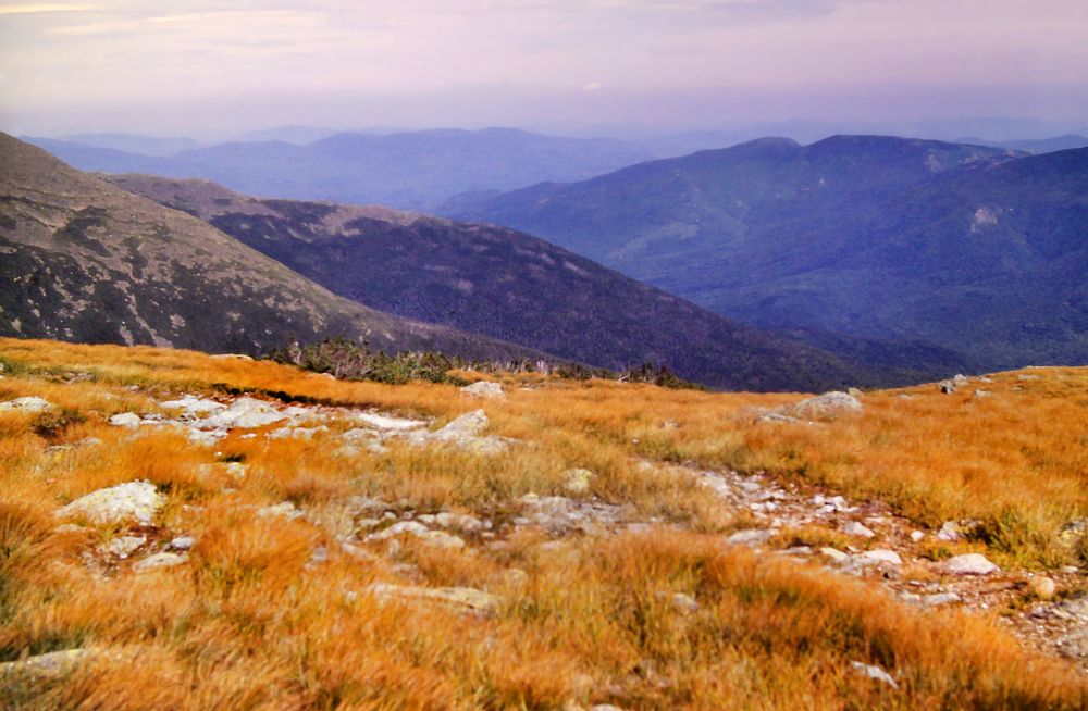
🧵4/10
clung to a few partially sheltered spots in and near the pass. The rest of the trail was across bare rock with patches of gold, grass-like plants about the height of a suburban lawn. I hung out for a while before descending into the col between Adams and Madison.
clung to a few partially sheltered spots in and near the pass. The rest of the trail was across bare rock with patches of gold, grass-like plants about the height of a suburban lawn. I hung out for a while before descending into the col between Adams and Madison.
December 11, 2025 at 3:34 PM
🧵4/10
clung to a few partially sheltered spots in and near the pass. The rest of the trail was across bare rock with patches of gold, grass-like plants about the height of a suburban lawn. I hung out for a while before descending into the col between Adams and Madison.
clung to a few partially sheltered spots in and near the pass. The rest of the trail was across bare rock with patches of gold, grass-like plants about the height of a suburban lawn. I hung out for a while before descending into the col between Adams and Madison.