HeiGIT
@heigit.org
480 followers 210 following 340 posts
Open-source geoinformation, methods and software for the benefit of the environment and society. --- This is the official account of HeiGIT (Heidelberg Institute for Geoinformation Technology) at Heidelberg University. Check us out at https://heigit.org/
Posts Media Videos Starter Packs
heigit.org
You live in #Karlsruhe and like to walk or cycle around?🚶🚴
Join us at the 𝗞𝗜𝗧 𝗦𝗰𝗶𝗲𝗻𝗰𝗲 𝗪𝗲𝗲𝗸 next Sunday:
We will take to the street by bike or on foot and collect insights on how public spaces can become more livable and bike-friendly.

📅Info & registration: heigit.org/events/kit-s...

@kit.edu
Text:
Workshop
Karlsruhe neu erleben: Straßen checken, Mobilität gestalten!
Tulla-Halle (11.40), KIT Campus Süd
19.10.2025, 13 Uhr

Bild: Zwei Personen zu Fuß und eine Person auf dem Fahrrad malen mit Stiften auf Papierkarten der Stadt
heigit.org
𝗨𝘀𝗶𝗻𝗴 𝗴𝗲𝗼𝗱𝗮𝘁𝗮 𝘁𝗼 𝗮𝗰𝘁 𝗯𝗲𝗳𝗼𝗿𝗲 𝗱𝗶𝘀𝗮𝘀𝘁𝗲𝗿𝘀 𝗵𝗶𝘁.
We’re working with Croix-Rouge Malagasy & German Red Cross to support anticipatory action in Madagascar:
▫️Training local teams on GIS to assess cyclone risk & trigger early action
▫️Developing an AI-based routing tool

🔗Blog: heigit.org/advancing-di...
Text: Advancing Disaster Preparedness with Data-Based Anticipatory Action
Photo: Woman wearing a Red Cross vest, seen from behind looking at a computer screen with a map on it
heigit.org
🌆⌛ 𝗜𝘀 𝘆𝗼𝘂𝗿 𝗰𝗶𝘁𝘆 𝗼𝗻 𝘁𝗿𝗮𝗰𝗸 𝘄𝗶𝘁𝗵 𝘁𝗵𝗲 𝗖𝗢₂ 𝗲𝗺𝗶𝘀𝘀𝗶𝗼𝗻 𝘁𝗮𝗿𝗴𝗲𝘁𝘀 𝗼𝗳 𝘁𝗵𝗲 #𝗣𝗮𝗿𝗶𝘀𝗔𝗴𝗿𝗲𝗲𝗺𝗲𝗻𝘁?
We have calculated the CO₂ budget for 5 German cities.
Check how much CO₂ they can still emit on the #𝗖𝗹𝗶𝗺𝗮𝘁𝗲𝗔𝗰𝘁𝗶𝗼𝗻𝗡𝗮𝘃𝗶𝗴𝗮𝘁𝗼𝗿:
📑 Blog post: heigit.org/unveiling-th...
📊 Data: climate-action.heigit.org/webapp/dashb...
heigit.org
𝗛𝗲𝗶𝗚𝗜𝗧 𝗮𝘁 𝗪𝗮𝗹𝗸𝟮𝟭🚶
HeiGIT is joining Walk21Conference with a talk on bridging perception and objectivity in walkability assessment.
We will explore how subjective perceptions of safety, comfort, and accessibility can diverge from objective walkability indicators.
🔍 heigit.org/events/heigi...
heigit.org
𝗛𝗲𝗶𝗚𝗜𝗧 𝗮𝘁 𝗦𝘁𝗮𝘁𝗲 𝗢𝗳 𝗧𝗵𝗲 𝗠𝗮𝗽 𝗪𝗼𝗿𝗹𝗱
From Oct 3-5, State of the Map World, the annual event for all mappers and OpenStreetMap users, takes place in Manila. HeiGIT will contribute with three sessions on OSM data for routing, openrouteservice and the current state of OSM.
🔍 heigit.org/events/heigi...
heigit.org
𝗠𝗮𝗽 𝗼𝗳 𝘁𝗵𝗲 𝗠𝗼𝗻𝘁𝗵 - 𝗣𝗮𝗿𝗸𝗶𝗻𝗴 𝗶𝗻 𝗕𝗲𝗿𝗹𝗶𝗻-𝗡𝗲𝘂𝗸ö𝗹𝗹𝗻
Sharing a path with side-parked cars increases the risk of dooring, i.e. being hit by a parking car🚲🚗
Our Climate Action Navigator´s hiBike uses OSM data to identify high-risk paths.

💡 climate-action.heigit.org/webapp/dashb...

#MobilityWeek #Cycling
heigit.org
𝗼𝗵𝘀𝗼𝗺𝗲 𝗗𝗮𝘀𝗵𝗯𝗼𝗮𝗿𝗱: 𝗧𝗵𝗲𝗺𝗮𝘁𝗶𝗰 𝗔𝗰𝗰𝘂𝗿𝗮𝗰𝘆 𝗼𝗳 𝗟𝗮𝗻𝗱 𝗖𝗼𝘃𝗲𝗿 𝗶𝗻 𝗚𝗲𝗿𝗺𝗮𝗻𝘆
Together with @bkgbund.bsky.social we've added a new indicator to assess the thematic accuracy of land cover data in #OSM. It compares OSM land use classifications with the official CORINE Land Cover data of BKG.
heigit.org/enhancing-os...
heigit.org
#WorldCarFreeDay is a reminder to reimagine #mobility

The hiBike assessment tool (in the Climate Action Navigator) measures urban #cycling infrastructure & helps cities target improvements.

👉https://climate-action.heigit.org/
🎵 Pixabay, AlexGrohl
#sustainablemobility #climateaction
heigit.org
𝐨𝐩𝐞𝐧𝐫𝐨𝐮𝐭𝐞𝐬𝐞𝐫𝐯𝐢𝐜𝐞 𝐮𝐬𝐞-𝐜𝐚𝐬𝐞: 𝐞𝗻𝗵𝗮𝗻𝗰𝗶𝗻𝗴 𝐬𝘂𝘀𝘁𝗮𝗶𝗻𝗮𝗯𝗹𝗲 𝐭𝗿𝗮𝘃𝗲𝗹 𝗶𝗻 𝐬𝗺𝗮𝗹𝗹 𝐜𝗶𝘁𝗶𝗲𝘀 𝗮𝗻𝗱 𝐨𝘂𝘁𝗲𝗿 𝐦𝗲𝘁𝗿𝗼𝗽𝗼𝗹𝗶𝘁𝗮𝗻 𝐚𝗿𝗲𝗮𝐬 🚶🚲
The ENHANCE project uses mapping, behavior research & simulations to design sustainable & inclusive mobility in smaller communities.
Read more: heigit.org/openrouteser...

#research #mobility
heigit.org
𝗖𝗮𝗹𝗹 𝗳𝗼𝗿 𝗔𝗽𝗽𝗹𝗶𝗰𝗮𝘁𝗶𝗼𝗻𝘀: 𝗥𝗼𝗯𝗲𝗿𝘁 𝗮𝗻𝗱 𝗖𝗵𝗿𝗶𝘀𝘁𝗶𝗻𝗲 𝗗𝗮𝗻𝘇𝗶𝗴𝗲𝗿 𝗦𝗰𝗵𝗼𝗹𝗮𝗿𝘀𝗵𝗶𝗽
The scholarship supports doctoral students from West & Central Africa, who intend to pursue a doctoral degree in Geography (Geoinformatics) at uniheidelberg.bsky.social
📆Applications: 15/09/25-15/03/26
💡More: heigit.org/call-for-app...
heigit.org
Our Road Surface Dataset has already been downloaded more than 4,000 times from #HDX!
It provides global information about road pavement and is being used for various scopes, including disaster response, environmental conservation & transport network planning: data.humdata.org/organization...
a truck driving offroad a map of the global distribution of road surface predictions (paved/unpaved)
heigit.org
𝗠𝗮𝗽𝗽𝗶𝗻𝗴 𝗛𝗶𝗴𝗵-𝗥𝗲𝘀𝗼𝗹𝘂𝘁𝗶𝗼𝗻 𝗖𝗮𝗿𝗯𝗼𝗻 𝗘𝗺𝗶𝘀𝘀𝗶𝗼𝗻 𝗦𝗽𝗮𝘁𝗶𝗮𝗹 𝗗𝗶𝘀𝘁𝗿𝗶𝗯𝘂𝘁𝗶𝗼𝗻 𝗖𝗼𝗺𝗯𝗶𝗻𝗲𝗱 𝘄𝗶𝘁𝗵 𝗖𝗮𝗿𝗯𝗼𝗻 𝗦𝗮𝘁𝗲𝗹𝗹𝗶𝘁𝗲 𝗮𝗻𝗱 𝗠𝘂𝗹𝘁𝗶-𝗦𝗼𝘂𝗿𝗰𝗲 𝗗𝗮𝘁𝗮🗺️

Full paper: www.mdpi.com/2072-4292/17...
Read more: heigit.org/new-paper-ma...
heigit.org
𝗛𝗲𝗶𝗚𝗜𝗧 𝗮𝘁 𝗝𝘂𝗻𝗴𝗲𝗿 𝗞𝗼𝗻𝗴𝗿𝗲𝘀𝘀 𝗳ü𝗿 𝗚𝗲𝗼𝗴𝗿𝗮𝗽𝗵𝗶𝗲
HeiGIT is taking part at JKG, which will take place in Leipzig from September 17-20.
Benjamin Herfort is hosting a session on inequalities & bias in OpenStreetMap, covering topics such as spatial inequality & bias.
heigit.org/events/heigi...
heigit.org
HeiGIT @heigit.org · Sep 4
How can cities protect walkers & cyclists from heat stress? In #Heidelberg, shade-optimized routing for 10k trips cut solar exposure with only small detours. A step toward cooler, healthier, more resilient cities.

👉 heigit.org/new-paper-mi...

#UrbanPlanning #ClimateAdaptation
heigit.org
HeiGIT @heigit.org · Sep 2
HeiGIT at EUGEO Congress 2025
Our session will focus on sustainable city planning, bringing together researchers working to advance public transport & active mobility choices.
💬Back to the future: the 15-min city & active mobility indicators
⏰ 11/09/2025, 9-10:30
heigit.org/events/heigi...
heigit.org
HeiGIT @heigit.org · Aug 29
𝗣𝗮𝗿𝘁𝗶𝗰𝗶𝗽𝗮𝘁𝗼𝗿𝘆 𝗺𝗮𝗽𝗽𝗶𝗻𝗴 𝗳𝗼𝗿 𝗱𝗶𝘀𝗮𝘀𝘁𝗲𝗿 𝗿𝗶𝘀𝗸 𝗿𝗲𝗱𝘂𝗰𝘁𝗶𝗼𝗻: 𝗖𝗮𝗿𝘁𝗮𝗴𝗲𝗻𝗮, 𝗖𝗵𝗶𝗹𝗲
Residents used the Sketch Map Tool to collect geoinformation for effective disaster risk reduction. The collaborative process fostered shared understanding & made the communities' priorities visible.
heigit.org?p=39840&prev...
heigit.org
HeiGIT @heigit.org · Aug 27
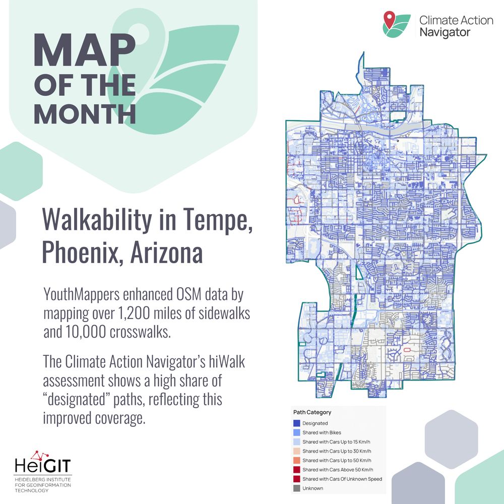
🌍 Map of the Month

#YouthMappers added 1,200+ miles of sidewalks & 10,000+ crosswalks in Tempe & Phoenix, improving #OpenStreetMap data.
These data feed into the Climate Action Navigator (CAN), a tool that uses OSM + open data to guide #climateaction

CAN: climate-action.heigit.org/webapp/dashb...
heigit.org
HeiGIT @heigit.org · Aug 26
How can crowdsourced geographic knowledge support #DisasterManagement?

We´ve selected 5 free, #open-source services and resources that integrate #VGI into disaster management. From customizable routing to #GIS training materials tailored to the #humanitarian sector

👉 heigit.org/five-open-so...
heigit.org
HeiGIT @heigit.org · Aug 21
Mapping energy poverty indices in urban scale🔋
While existing energy poverty indices are designed for national-scale assessments, they often fail to capture the differences within cities. This study adapts macro-scale energy poverty indices to the urban context.
heigit.org/new-paper-ma...
heigit.org
HeiGIT @heigit.org · Aug 20
Bringing Community Mapping to GIScience 2025 🌍

Anne Schauss & Diego Pajarito (University of Glasgow) will co-host a workshop on participatory, and share insights from case studies on how these initiatives shape communities.

👉 heigit.org/events/heigi...

#CommunityMapping, #ParticipatoryResearch
heigit.org
HeiGIT @heigit.org · Aug 19
📢 𝐍𝐞𝐰 𝐭𝐮𝐭𝐨𝐫𝐢𝐚𝐥 𝐨𝐧 𝐮𝐬𝐢𝐧𝐠 𝐨𝐮𝐫 𝐠𝐥𝐨𝐛𝐚𝐥 𝐫𝐨𝐚𝐝 𝐬𝐮𝐫𝐟𝐚𝐜𝐞 𝐝𝐚𝐭𝐚𝐬𝐞𝐭

overlay road surface + population data
spot infrastructure gaps where many depend on poor/undocumented roads
explore data with open tools (DuckDB, Mercantile, Shapely)

👉 heigit.org/identifying-...
#GeoAI #OpenData #OSM #Mapillary
heigit.org
HeiGIT @heigit.org · Aug 18
𝗛𝗼𝘄 𝗱𝗼 𝘄𝗲 𝗱𝗲𝘀𝗶𝗴𝗻 𝗶𝗻𝗰𝗹𝘂𝘀𝗶𝘃𝗲 𝗰𝗶𝘁𝗶𝗲𝘀 𝘄𝗶𝘁𝗵 𝘀𝗲𝗻𝗶𝗼𝗿 𝗰𝗶𝘁𝗶𝘇𝗲𝗻𝘀 𝗶𝗻 𝗺𝗶𝗻𝗱?
Most navigation tools ignore cracked pavements, steep slopes or poor lighting, which are important for age-friendly routing. Our new paper identifies key factors, gaps & how to make routing more age-inclusive.
heigit.org/new-paper-ro...
heigit.org
HeiGIT @heigit.org · Aug 13
How walkable is your neighborhood? Senior citizens in #Mannheim can now share their views in an online survey, part of the research project "Silver Ways".
The survey results will be used to to support the development of safer, more accessible urban routes.
Read more: heigit.org/a-walkable-c...
Decorative motives and text: "A Walkable City for All Generations? Take the Silver Ways Survey and share your experience in Mannheim". Beside the text, there is a QR code that leads to the following webiste: survey.silverways.de
heigit.org
HeiGIT @heigit.org · Aug 12
𝗣𝗿𝗼𝗳. 𝗗𝗿. 𝗔𝗹𝗲𝘅𝗮𝗻𝗱𝗲𝗿 𝗭𝗶𝗽𝗳 𝗮𝘁 𝘁𝗵𝗲 𝗜𝗖𝗖 𝟮𝟬𝟮𝟱
Prof. Zipf is part of the keynote series of the International Cartographic Conference, taking place in Vancouver, Canada from 17 - 22 August.
🗣️Beyond user-generated maps – where crowd intelligence meets artificial intelligence
🔍 heigit.org/events/prof-...
heigit.org
HeiGIT @heigit.org · Aug 11
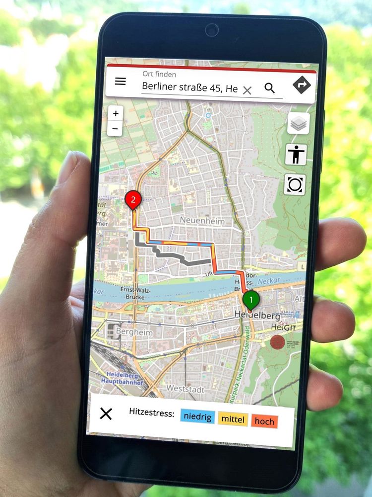
🥵🚶𝗪𝗮𝗹𝗸𝗶𝗻𝗴 𝗶𝗻 𝘁𝗵𝗲 𝗰𝗶𝘁𝘆 𝘂𝗻𝗱𝗲𝗿 𝘁𝗵𝗲 𝗵𝗼𝘁 𝘀𝘂𝗺𝗺𝗲𝗿 𝘀𝘂𝗻?
The 𝗛𝗘𝗔𝗟 𝗮𝗽𝗽 recommends pedestrian routes based on their “coolness”, favoring shadowy, vegetation-rich streets.
The app is available in #Heidelberg and now also in #Worms: worms.heal.openrouteservice.org

Read how it works: heigit.org/a-routing-ap...