


Hidden Hydrology
@hiddenhydrology.bsky.social
Exploring lost rivers, buried creeks & disappeared streams. Connecting historic ecology + the modern metropolis with a focus on Portland and Seattle.
https://linktr.ee/jasonandrewking
https://linktr.ee/jasonandrewking
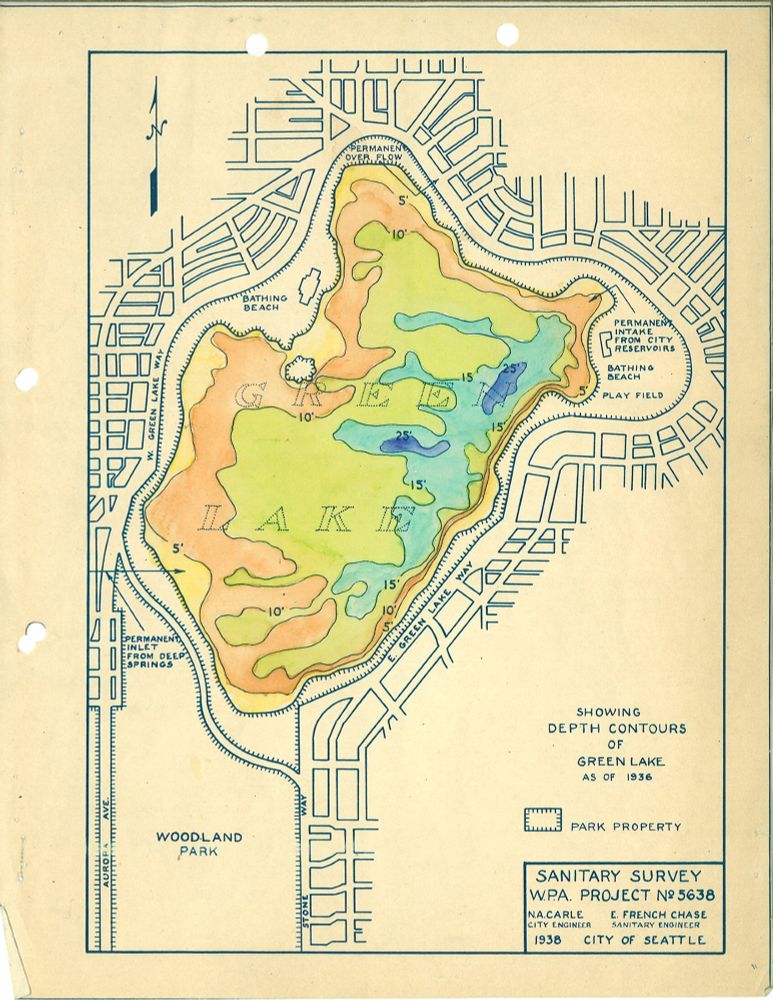
This 1938 map of Seattle's Green Lake was included in a report on algae control for the lake, conducted by the WPA. The map highlights the relative depths, or bathymetry, of the lake as colors, in 5' increments, the dark blue showing depths of around 25' depth.
#seattle #hiddenhydrology #maps
#seattle #hiddenhydrology #maps
December 4, 2025 at 4:02 PM
This 1938 map of Seattle's Green Lake was included in a report on algae control for the lake, conducted by the WPA. The map highlights the relative depths, or bathymetry, of the lake as colors, in 5' increments, the dark blue showing depths of around 25' depth.
#seattle #hiddenhydrology #maps
#seattle #hiddenhydrology #maps
Seattle's topography was a constant challenge to development and expansion and multiple regrades were implemented to sluice away hillsides using high pressure water cannons. The blow image shows an example of this c1910, via
@historylink.bsky.social
@historylink.bsky.social

December 1, 2025 at 4:45 AM
Seattle's topography was a constant challenge to development and expansion and multiple regrades were implemented to sluice away hillsides using high pressure water cannons. The blow image shows an example of this c1910, via
@historylink.bsky.social
@historylink.bsky.social
This c1885 view of the south shore of Lake Union, (which looks a little different today as the home of Amazon) shows the Western Mill Company (right) and Queen Anne Hill across the other side of the lake. Via @historylink.bsky.social Courtesy Washington State Digital Archives (AR-07809001-ph003736)

November 27, 2025 at 4:29 PM
This c1885 view of the south shore of Lake Union, (which looks a little different today as the home of Amazon) shows the Western Mill Company (right) and Queen Anne Hill across the other side of the lake. Via @historylink.bsky.social Courtesy Washington State Digital Archives (AR-07809001-ph003736)