


Jeff Allen
@jamaps.bsky.social
maps, graphics, cities, etc.
website: https://jamaps.github.io/
github: https://github.com/jamaps
~9-5 M-F: https://schoolofcities.utoronto.ca/research-type/data-visualization/
website: https://jamaps.github.io/
github: https://github.com/jamaps
~9-5 M-F: https://schoolofcities.utoronto.ca/research-type/data-visualization/
recent fun scrolly-maps by Aniket Kali and I on history of languages in Toronto
schoolofcities.github.io/languages/to...
#toronto #history #maps #languages
schoolofcities.github.io/languages/to...
#toronto #history #maps #languages
January 15, 2026 at 4:14 PM
recent fun scrolly-maps by Aniket Kali and I on history of languages in Toronto
schoolofcities.github.io/languages/to...
#toronto #history #maps #languages
schoolofcities.github.io/languages/to...
#toronto #history #maps #languages
couple interesting maps of climate change vulnerability across Canada by Isabeaux Graham on our team
check out more here: schoolofcities.utoronto.ca/layers-of-cl...
#maps #gis #canada #climateChange
check out more here: schoolofcities.utoronto.ca/layers-of-cl...
#maps #gis #canada #climateChange


January 14, 2026 at 9:23 PM
couple interesting maps of climate change vulnerability across Canada by Isabeaux Graham on our team
check out more here: schoolofcities.utoronto.ca/layers-of-cl...
#maps #gis #canada #climateChange
check out more here: schoolofcities.utoronto.ca/layers-of-cl...
#maps #gis #canada #climateChange

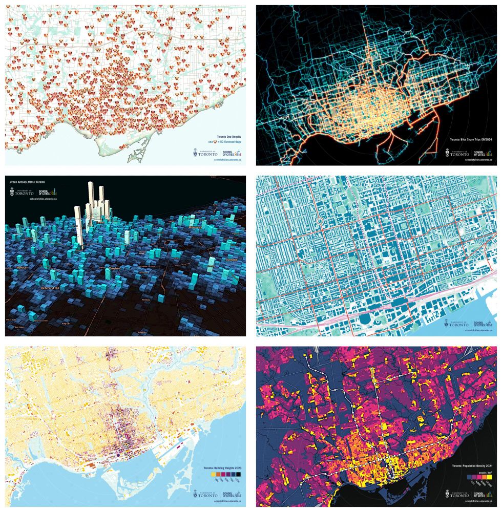
recently updated a grid gallery of my maps on my personal website/portfolio -
check it out here :) jamaps.github.io/maps.html
#maps #dataviz #gis
check it out here :) jamaps.github.io/maps.html
#maps #dataviz #gis

January 4, 2026 at 8:18 PM
recently updated a grid gallery of my maps on my personal website/portfolio -
check it out here :) jamaps.github.io/maps.html
#maps #dataviz #gis
check it out here :) jamaps.github.io/maps.html
#maps #dataviz #gis
interesting short-lived TTC subway map from 2007 with 5 lines/routes
source: transittoronto.ca/spare/0053.s...
#toronto #transit #ttc #maps
source: transittoronto.ca/spare/0053.s...
#toronto #transit #ttc #maps

December 23, 2025 at 8:04 PM
interesting short-lived TTC subway map from 2007 with 5 lines/routes
source: transittoronto.ca/spare/0053.s...
#toronto #transit #ttc #maps
source: transittoronto.ca/spare/0053.s...
#toronto #transit #ttc #maps
made a map of Beirut yesterday
testing out a textured-greyscale style this time
#maps #beirut #rayshader #qgis #gimp
testing out a textured-greyscale style this time
#maps #beirut #rayshader #qgis #gimp

December 22, 2025 at 1:52 PM
made a map of Beirut yesterday
testing out a textured-greyscale style this time
#maps #beirut #rayshader #qgis #gimp
testing out a textured-greyscale style this time
#maps #beirut #rayshader #qgis #gimp
iterating on a map of Cuba via rayshader and gimp
testing out some different coastline/hierarchy effects this time
#cuba #rayshader #gimp #maps
testing out some different coastline/hierarchy effects this time
#cuba #rayshader #gimp #maps

December 21, 2025 at 7:06 PM
iterating on a map of Cuba via rayshader and gimp
testing out some different coastline/hierarchy effects this time
#cuba #rayshader #gimp #maps
testing out some different coastline/hierarchy effects this time
#cuba #rayshader #gimp #maps

December 18, 2025 at 8:16 PM
trying to learn how to use rayshader - made this map of Ireland during the process
#ireland #rayshader #maps
#ireland #rayshader #maps

December 18, 2025 at 2:39 PM
trying to learn how to use rayshader - made this map of Ireland during the process
#ireland #rayshader #maps
#ireland #rayshader #maps

December 11, 2025 at 12:39 AM
Chart comparing minimum wages to local living wages across Canada
Created by Isabeaux Graham on our team for this report: schoolofcities.utoronto.ca/wp-content/u...
Created by Isabeaux Graham on our team for this report: schoolofcities.utoronto.ca/wp-content/u...

December 9, 2025 at 12:55 PM
Chart comparing minimum wages to local living wages across Canada
Created by Isabeaux Graham on our team for this report: schoolofcities.utoronto.ca/wp-content/u...
Created by Isabeaux Graham on our team for this report: schoolofcities.utoronto.ca/wp-content/u...
Map we made for the School of Cities' Learning From What Works project — a major report profiling 89 amazing community projects and organizations from across Canada
Check out the report here: schoolofcities.utoronto.ca/research-pub...
Check out the report here: schoolofcities.utoronto.ca/research-pub...

December 5, 2025 at 1:16 PM
Map we made for the School of Cities' Learning From What Works project — a major report profiling 89 amazing community projects and organizations from across Canada
Check out the report here: schoolofcities.utoronto.ca/research-pub...
Check out the report here: schoolofcities.utoronto.ca/research-pub...
Ottawa figure-ground type map digression from this morning
higher-res here: jamaps.github.io/maps/ott-bui...
#ottawa #maps
higher-res here: jamaps.github.io/maps/ott-bui...
#ottawa #maps

December 3, 2025 at 12:42 PM
Ottawa figure-ground type map digression from this morning
higher-res here: jamaps.github.io/maps/ott-bui...
#ottawa #maps
higher-res here: jamaps.github.io/maps/ott-bui...
#ottawa #maps
recent map experiment of Toronto's terrain
made via QGIS/Inkscape/GIMP and TIN data from @torontoopendata.cityof.toronto.ca
higher-res here: jamaps.github.io/maps/terrain...
#toronto #maps #terrain #topography
made via QGIS/Inkscape/GIMP and TIN data from @torontoopendata.cityof.toronto.ca
higher-res here: jamaps.github.io/maps/terrain...
#toronto #maps #terrain #topography

December 2, 2025 at 1:49 PM
recent map experiment of Toronto's terrain
made via QGIS/Inkscape/GIMP and TIN data from @torontoopendata.cityof.toronto.ca
higher-res here: jamaps.github.io/maps/terrain...
#toronto #maps #terrain #topography
made via QGIS/Inkscape/GIMP and TIN data from @torontoopendata.cityof.toronto.ca
higher-res here: jamaps.github.io/maps/terrain...
#toronto #maps #terrain #topography
Recently made a few maps of the new Finch West Line 6 + surrounding land-use
More here: schoolofcities.utoronto.ca/maps-of-line...
#toronto #transit #maps
More here: schoolofcities.utoronto.ca/maps-of-line...
#toronto #transit #maps

November 29, 2025 at 4:02 PM
Recently made a few maps of the new Finch West Line 6 + surrounding land-use
More here: schoolofcities.utoronto.ca/maps-of-line...
#toronto #transit #maps
More here: schoolofcities.utoronto.ca/maps-of-line...
#toronto #transit #maps
Line 6 Finch West is opening soon - here's a chart of 25 years of population change along the route
I adapted this from Michael Liu's great work here: schoolofcities.github.io/tod-toronto-...
#transit #dataviz #toronto
I adapted this from Michael Liu's great work here: schoolofcities.github.io/tod-toronto-...
#transit #dataviz #toronto

November 27, 2025 at 5:15 PM
Line 6 Finch West is opening soon - here's a chart of 25 years of population change along the route
I adapted this from Michael Liu's great work here: schoolofcities.github.io/tod-toronto-...
#transit #dataviz #toronto
I adapted this from Michael Liu's great work here: schoolofcities.github.io/tod-toronto-...
#transit #dataviz #toronto
Charting number of rental units in apartment buildings in Toronto by year of construction
(This is a quick update to a similar chart I made ~2.5 years ago)
#toronto #housing #dataviz #NationalHousingDay
(This is a quick update to a similar chart I made ~2.5 years ago)
#toronto #housing #dataviz #NationalHousingDay

November 22, 2025 at 1:03 PM
Charting number of rental units in apartment buildings in Toronto by year of construction
(This is a quick update to a similar chart I made ~2.5 years ago)
#toronto #housing #dataviz #NationalHousingDay
(This is a quick update to a similar chart I made ~2.5 years ago)
#toronto #housing #dataviz #NationalHousingDay
Graphics from our recent case study "From Tracks to Trail: Planning for equitable (re)development" (Albuquerque, New Mexico)
Read it here: schoolofcities.github.io/eddit/albuqu...
#maps #dataviz
Read it here: schoolofcities.github.io/eddit/albuqu...
#maps #dataviz


September 26, 2025 at 2:08 PM
Graphics from our recent case study "From Tracks to Trail: Planning for equitable (re)development" (Albuquerque, New Mexico)
Read it here: schoolofcities.github.io/eddit/albuqu...
#maps #dataviz
Read it here: schoolofcities.github.io/eddit/albuqu...
#maps #dataviz

quickly mapped out estimates of what % of children are driven to school in the greater toronto/hamilton area
check out more related maps from this data here: schoolofcities.github.io/transportati...
check out more related maps from this data here: schoolofcities.github.io/transportati...

September 2, 2025 at 8:50 PM
quickly mapped out estimates of what % of children are driven to school in the greater toronto/hamilton area
check out more related maps from this data here: schoolofcities.github.io/transportati...
check out more related maps from this data here: schoolofcities.github.io/transportati...
recent maps/scrollytelling piece on under-valued surface parking lots in Toronto (via an analysis of property tax data)
view the project here: schoolofcities.github.io/underutilize...
#toronto #maps #dataviz #parking
view the project here: schoolofcities.github.io/underutilize...
#toronto #maps #dataviz #parking
August 21, 2025 at 5:20 PM
recent maps/scrollytelling piece on under-valued surface parking lots in Toronto (via an analysis of property tax data)
view the project here: schoolofcities.github.io/underutilize...
#toronto #maps #dataviz #parking
view the project here: schoolofcities.github.io/underutilize...
#toronto #maps #dataviz #parking
I like this new raised pedestrian crossing at Draper and Wellington
#toronto #urbandesign #walkability
#toronto #urbandesign #walkability

August 20, 2025 at 12:22 AM
I like this new raised pedestrian crossing at Draper and Wellington
#toronto #urbandesign #walkability
#toronto #urbandesign #walkability
recently updated and printed more @uoftcities.bsky.social Toronto-map-viz postcards
planning to give out a bunch at Civic Spark tomorrow
#maps #dataviz #toronto
planning to give out a bunch at Civic Spark tomorrow
#maps #dataviz #toronto
August 15, 2025 at 6:58 PM
recently updated and printed more @uoftcities.bsky.social Toronto-map-viz postcards
planning to give out a bunch at Civic Spark tomorrow
#maps #dataviz #toronto
planning to give out a bunch at Civic Spark tomorrow
#maps #dataviz #toronto
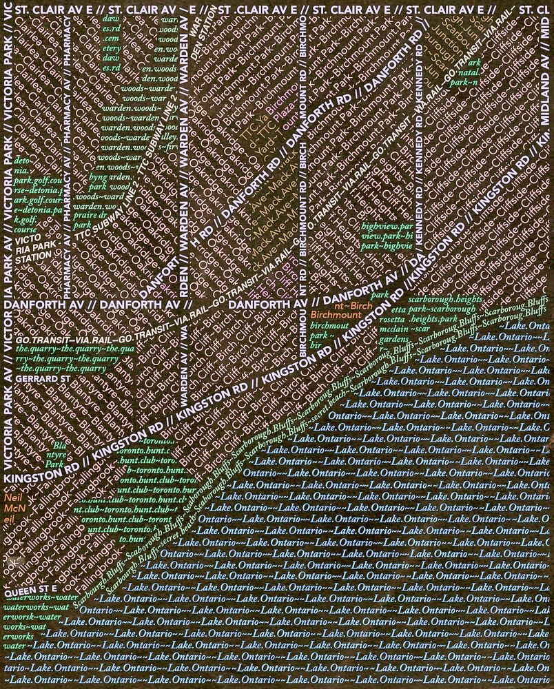
typographic map experiment of southwest Scarborough
(an older project, recent tinkering)
#scarborough #maps #typography
(an older project, recent tinkering)
#scarborough #maps #typography
June 30, 2025 at 5:29 PM
typographic map experiment of southwest Scarborough
(an older project, recent tinkering)
#scarborough #maps #typography
(an older project, recent tinkering)
#scarborough #maps #typography
helped create a few maps of heat vulnerability in Toronto around this time last year
thought today's a good time to re-share
check out more here! - schoolofcities.github.io/heat-vulnera...
#toronto #heat #maps
thought today's a good time to re-share
check out more here! - schoolofcities.github.io/heat-vulnera...
#toronto #heat #maps

June 23, 2025 at 1:01 PM
helped create a few maps of heat vulnerability in Toronto around this time last year
thought today's a good time to re-share
check out more here! - schoolofcities.github.io/heat-vulnera...
#toronto #heat #maps
thought today's a good time to re-share
check out more here! - schoolofcities.github.io/heat-vulnera...
#toronto #heat #maps