Jan Beutel
@janbeutel.bsky.social
460 followers 94 following 39 posts
Passionate about mountains, cryosphere, natural hazards and technology to help with all that adaptation before us, professor @uniinnsbruck, UIAGM mountain guide
Posts Media Videos Starter Packs
janbeutel.bsky.social
Tirol und das Wallis diskutieren um die gleiche Vision: Mehr Wasserkraft aus den Bergen. Aber voneinander Wissen und Lernen ist bisher Fehlanzeige. #kaunertal #gornerli
orfreport.bsky.social
Tirol: Das Platzertal soll einem Stausee weichen - saubere Energie gegen unberührte Natur. Ein Zielkonflikt, heute im #Report.
janbeutel.bsky.social
Check out the great lineup of speakers for our workshop tomorrow "The avalanche disaster in Blatten"
where first insights and science results will be discussed.

THU 18.09.2024 08:30-12:00h at IMC'25 in Innsbruck:

imc2025.info/imc25/sessio...

#blatten #rockfall #permafrost #glaciers
#IMC25 - The avalanche disaster in Blatten
imc2025.info
Reposted by Jan Beutel
scnat.ch
SCNAT @scnat.ch · Jun 17
🌡️ Der #Permafrost in den Schweizer #Alpen war 2024 so warm wie noch nie – das zeigen die neuesten Daten des Beobachtungsnetzwerks #PERMOS. Diese Veränderungen werden sich auch in den kommenden Jahren und Jahrzehnten fortsetzen ➡️ scnat.ch/de/id/WbQd9
#Klima #Klimawandel
Geophysikmessungen neben dem Bohrloch und der Meteostation auf dem Stockhorn. Der Text lautet: «Permafrost in den Schweizer Alpen – 2024 war ein weiteres Rekordjahr».
janbeutel.bsky.social
Seeing #Blatten and the #Nesthorn collapse for real does leave a lasting impression. Yellow CAT excavators waiting look like ants.
janbeutel.bsky.social
Same ballpark as the media conf yesterday (9mio) and great we can have such analysis do quickly
janbeutel.bsky.social
Samidha, this is from the seismic networks accessible via FDSN. mass movements are tracked and cataloged by SED since a couple of years:

seismo.ethz.ch/en/earthquak...
SED | Switzerland
Earthquakes Switzerland
seismo.ethz.ch
janbeutel.bsky.social
That's because i already had a sip at the 🍺before the 📸
janbeutel.bsky.social
The evac was based on pre-failure analysis of an imminent, very large rockfall. An in-situ GNSS sensor installed on friday 16th on the ridge as well as a first large rockfall caused the evac decision monday. Fun fact, the GNSS fell with one of the first rockfall events monday afternoon.
janbeutel.bsky.social
And no: "...Emergency managers had been observing increased glacier melt at Birch Glacier, ordering hundreds of villagers to evacuate after debris from the mountain behind the glacier crumbled days before the catastrophic collapse."
janbeutel.bsky.social
Its an awkward article mixing different quotes, specifics and non-specifics as well as non truths. only one example: "...can melt permafrost..." - well if solid ground melted that would be lava i'm afraid. also
janbeutel.bsky.social
After a full day of non stop interviews on rockfall, glaciers, permafrost and Valais natural hazard management it’s nice to end the day in a peaceful mountain setting. Why is it that despite how many times you explain that rocks fall because of this climate thingy they still put it in the headlines?
janbeutel.bsky.social
All these events register nicely on the map. This is the biggest rockfall event and the seismic signal geolocates just at the base of the ridge. Also the geological situation and the permafrost question is illustrated (darker violet/blue means permafrost is more likely than yellow).
janbeutel.bsky.social
Another magnitude 1.0 event was registered yesterday at 2025-05-29 12:34 in #Blatten. In the line of the 15 events registered over the past two weeks this one parks in at a moderate scale. And just another reminder that the mountain has not yet reached an equilibrium state yet.
janbeutel.bsky.social
somehow i like this pointy hill. only why?😀
Reposted by Jan Beutel
watershedlab.bsky.social
Absolutely stunning ultra-high resolution @planet.com SkySat imagery of the Klein Nesthorn landslide, which buried the village of Blatten, Switzerland yesterday. @davepetley.bsky.social @eth-eaps.bsky.social @vaw-glaciology.bsky.social @kristencook.bsky.social @annepellegrino.bsky.social 🧪⚒️🛰️
Satellite image of a landslide-dammed lake in Switzerland, which is flooding homes Massive landslide in a Swiss valley
janbeutel.bsky.social
Methods that were groundbreaking in basic research are now butter and bread go-to-methods - in real time: 15:24h event happens, 15:30h E sent email request to SED to quickly check magnitude because of deteriorating visibility, 15:39 we KNOW it's M=3.1
janbeutel.bsky.social
And there clearly is another thing "posterchild" about this. The remarkable capabilities and calmness in mitigation combined with innovative monitoring and assessment methods.
janbeutel.bsky.social
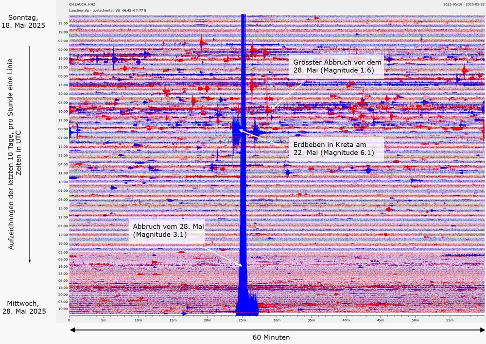
Swiss Seismological Survey published a nice overview plot of the earth shaking and wobbling as response to first a series of rockfalls/rockslides onto the Birchgletscher and then finally more and more mumbling and rumbling leading to the final break-off.
janbeutel.bsky.social
The Birchgletscher collapse shook the Matterhorn!

Not really a surprise but a fun fact that the collapse of the Birchgletscher is clearly visible at our high-altitude seismic station Solvay 4003 m a.s.l. up on the Hörnliridge (bottom left).
janbeutel.bsky.social
So what you are describing is the start of the failure process, then it takes some time until the sliding and tumbling creates enough energy for the big signal (the impacts downstream). This is the details from SED
janbeutel.bsky.social
Suddenly, after a lot of this and that rumbling and spurious break-offs the whole video screen was erupting. A detailed side by side of video and seismic will show. But it does take time to build up the energy.
janbeutel.bsky.social
I was clicking on and off the live stream video yesterday trying to concentrate on some other work. When noise started getting denser, rumbling more i got hooked and therefore saw the whole collapse on camera end-to-end. Also struggled screenshotting and filling bsky.social at the same time.
janbeutel.bsky.social
@davepetley.bsky.social wrote on the landslide blog: "... it is interesting that there was an elevated signal in the two minutes or so before the catastrophic failure began. What was this? Was movement starting to occur in the Birch Glacier, or was there an event on the slope above ?"