


Jim Teske
@jimteskenc9.bsky.social
Chief Meteorologist WSYR-TV | AMS Certified Broadcast Meteorologist #477 SYR>OSW>PSU>BTV>PWM>SYR
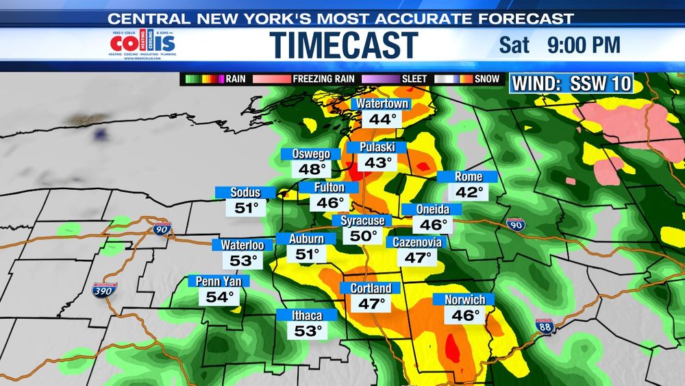
Snow moves in after midnight tonight with up to an inch of snow by morning. Another 1 to 2" in Syracuse tomorrow morning but 2-4" over higher elevations. Temperatures rise above freezing in the afternoon so roads are better for evening commute than the morning.


December 22, 2025 at 10:39 PM
Snow moves in after midnight tonight with up to an inch of snow by morning. Another 1 to 2" in Syracuse tomorrow morning but 2-4" over higher elevations. Temperatures rise above freezing in the afternoon so roads are better for evening commute than the morning.
Lake effect snow organizing east of Lake Ontario over S. Jefferson/N. Lewis Counties. This band moves south this evening and weakens after midnight close to Syracuse. 3-6" possible over parts of the Tug Hill.


December 19, 2025 at 10:26 PM
Lake effect snow organizing east of Lake Ontario over S. Jefferson/N. Lewis Counties. This band moves south this evening and weakens after midnight close to Syracuse. 3-6" possible over parts of the Tug Hill.
Winds in Syracuse are likely to gust past 40 mph through Friday evening before diminishing overnight. Winds are much lighter tomorrow but pick up again out of the south tomorrow night.


December 19, 2025 at 9:59 PM
Winds in Syracuse are likely to gust past 40 mph through Friday evening before diminishing overnight. Winds are much lighter tomorrow but pick up again out of the south tomorrow night.
Wind is picking up tonight in Syracuse with 40 mph after midnight. HEADS UP: Some heavier showers during Friday morning commute could cause brief gusts past 50 mph. While not as strong the rest of Friday, still some gusts around 40-45 mph.


December 18, 2025 at 10:36 PM
Wind is picking up tonight in Syracuse with 40 mph after midnight. HEADS UP: Some heavier showers during Friday morning commute could cause brief gusts past 50 mph. While not as strong the rest of Friday, still some gusts around 40-45 mph.
Here comes our 'December Thaw.' Syracuse likely to have its first day at 40° of higher of the month tomorrow. 40s in the forecast through Friday morning then we back off again.

December 16, 2025 at 10:00 PM
Here comes our 'December Thaw.' Syracuse likely to have its first day at 40° of higher of the month tomorrow. 40s in the forecast through Friday morning then we back off again.
One more burst of lake effect snow tonight north of Syracuse focused on S Jefferson/N. Oswego and W. Lewis Counties where a foot or more of snow could fall. Little if any accumulation in Syracuse this evening from snow showers.


December 15, 2025 at 10:28 PM
One more burst of lake effect snow tonight north of Syracuse focused on S Jefferson/N. Oswego and W. Lewis Counties where a foot or more of snow could fall. Little if any accumulation in Syracuse this evening from snow showers.
Here is our latest snowfall map for Thursday's lake effect. No major changes from the map we posted yesterday. Biggest impacts on travel around Syracuse come late morning into the evening.

December 10, 2025 at 10:28 PM
Here is our latest snowfall map for Thursday's lake effect. No major changes from the map we posted yesterday. Biggest impacts on travel around Syracuse come late morning into the evening.
Syracuse is in the midst of one of its longer stretches of temperatures cooler compared to average in recent memory over the last 2 weeks. It will come as no surprise that December is running about 10 degrees below average though the first week of the month.

December 10, 2025 at 3:21 AM
Syracuse is in the midst of one of its longer stretches of temperatures cooler compared to average in recent memory over the last 2 weeks. It will come as no surprise that December is running about 10 degrees below average though the first week of the month.
Thursday it is localized lake effect and it should be down close to Syracuse. Winter Storm Watches up including Onondaga County. Where squalls are more persistent 6-12" are possible. (2/2)

December 9, 2025 at 10:26 PM
Thursday it is localized lake effect and it should be down close to Syracuse. Winter Storm Watches up including Onondaga County. Where squalls are more persistent 6-12" are possible. (2/2)
Two active winter weather days for Central New York. Wednesday its a widespread snow. Temperatures around Syracuse go above freezing which limits snowfall potential. However, over high elevations 6" or more are possible. (1/2)

December 9, 2025 at 10:26 PM
Two active winter weather days for Central New York. Wednesday its a widespread snow. Temperatures around Syracuse go above freezing which limits snowfall potential. However, over high elevations 6" or more are possible. (1/2)
Arctic air over Syracuse and Central New York Friday. The high was 27° which is 14 degrees below normal for December 5th. For additional perspective, 27° is our normal low for today's date.

December 5, 2025 at 10:35 PM
Arctic air over Syracuse and Central New York Friday. The high was 27° which is 14 degrees below normal for December 5th. For additional perspective, 27° is our normal low for today's date.
With at least 2.5" of snow today, Syracuse cracked two feet of snow for the season, almost a foot above normal. Last winter it took until January 2nd to hit two feet and in the winter of 2023-'24 it was January 18th or 45 days later than this winter!

December 5, 2025 at 1:40 AM
With at least 2.5" of snow today, Syracuse cracked two feet of snow for the season, almost a foot above normal. Last winter it took until January 2nd to hit two feet and in the winter of 2023-'24 it was January 18th or 45 days later than this winter!
With lake effect snow dropping south of Syracuse after sunset, arctic air dropping into Central New York. Syracuse will have its coldest morning since Groundhog's Day (we're forecasting +4F) but wind chills should be below zero from Syracuse east.🥶

December 4, 2025 at 9:16 PM
With lake effect snow dropping south of Syracuse after sunset, arctic air dropping into Central New York. Syracuse will have its coldest morning since Groundhog's Day (we're forecasting +4F) but wind chills should be below zero from Syracuse east.🥶
Here in Syracuse the snow Tuesday will not be as much as what we saw on Friday, but the timing of the steadiest (and heaviest) snow will coincide with the morning commute. Give yourself extra time. Just flurries for evening commute.


December 1, 2025 at 10:08 PM
Here in Syracuse the snow Tuesday will not be as much as what we saw on Friday, but the timing of the steadiest (and heaviest) snow will coincide with the morning commute. Give yourself extra time. Just flurries for evening commute.
Friday: Lake snow drops south Thursday night and will be in the Syracuse area Friday. There is a broad area of 4-8" southeast of Lake Ontario possible with localized totals near a foot, perhaps even including Syracuse. Again, winds will cause blowing and drifting. (2/3)


November 26, 2025 at 10:38 PM
Friday: Lake snow drops south Thursday night and will be in the Syracuse area Friday. There is a broad area of 4-8" southeast of Lake Ontario possible with localized totals near a foot, perhaps even including Syracuse. Again, winds will cause blowing and drifting. (2/3)
Here is the breakdown on CNY wx the next few days.
Thanksgiving Day: Lake snow is nr the Tug Hill where 8-12" of snow falls with low visibilities near Syracuse. For the rest of Central New York (including SYR) snow showers w/ light accumulation possible s of SYR. Gusty winds for all.(1/3)
Thanksgiving Day: Lake snow is nr the Tug Hill where 8-12" of snow falls with low visibilities near Syracuse. For the rest of Central New York (including SYR) snow showers w/ light accumulation possible s of SYR. Gusty winds for all.(1/3)


November 26, 2025 at 10:38 PM
Here is the breakdown on CNY wx the next few days.
Thanksgiving Day: Lake snow is nr the Tug Hill where 8-12" of snow falls with low visibilities near Syracuse. For the rest of Central New York (including SYR) snow showers w/ light accumulation possible s of SYR. Gusty winds for all.(1/3)
Thanksgiving Day: Lake snow is nr the Tug Hill where 8-12" of snow falls with low visibilities near Syracuse. For the rest of Central New York (including SYR) snow showers w/ light accumulation possible s of SYR. Gusty winds for all.(1/3)
Lake effect the big story in Central New York later in the week. Through midweek, though, it is mild with some rain/showers. Even Thanksgiving snow showers won't amount to much in Syracuse. Biggest impact day for SYR is Friday. Likely some localized spots of 6" or more.

November 25, 2025 at 12:58 AM
Lake effect the big story in Central New York later in the week. Through midweek, though, it is mild with some rain/showers. Even Thanksgiving snow showers won't amount to much in Syracuse. Biggest impact day for SYR is Friday. Likely some localized spots of 6" or more.
After a cold night last night (Syracuse dropped to 24°!) look for another frosty start over Central New York Thursday morning. Thankfully, sunshine gets our temperatures back into the 40s in the afternoon.

November 19, 2025 at 10:51 PM
After a cold night last night (Syracuse dropped to 24°!) look for another frosty start over Central New York Thursday morning. Thankfully, sunshine gets our temperatures back into the 40s in the afternoon.
Today was the first day over the last 10 that Syracuse had no measurable precipitation. There was a little snow in the air before sunrise which means only three of the first 18 days this month have been totally rain/snow free.

November 18, 2025 at 10:58 PM
Today was the first day over the last 10 that Syracuse had no measurable precipitation. There was a little snow in the air before sunrise which means only three of the first 18 days this month have been totally rain/snow free.
Have some late season yard work to do Saturday? Here in Syracuse we are dry through early afternoon with a few showers after 2 pm. A steadier rain arrives after sunset.

November 14, 2025 at 9:48 PM
Have some late season yard work to do Saturday? Here in Syracuse we are dry through early afternoon with a few showers after 2 pm. A steadier rain arrives after sunset.
Syracuse is already running 2.2° F below normal for November and temperatures remain below normal for the next 7 days. We could be headed to our coolest November since 2019.
November 13, 2025 at 10:23 PM
Syracuse is already running 2.2° F below normal for November and temperatures remain below normal for the next 7 days. We could be headed to our coolest November since 2019.
Here is the tonight AND Tomorrow breakdown of lake effect snow. The worst weather for Syracuse is centered around tomorrow morning's commute. Syracuse ends up with a storm total of 4-7" by early evening Tuesday but localized areas of 7-10" N. Onondaga, N. Cayuga, Wayne Counties.


November 10, 2025 at 9:56 PM
Here is the tonight AND Tomorrow breakdown of lake effect snow. The worst weather for Syracuse is centered around tomorrow morning's commute. Syracuse ends up with a storm total of 4-7" by early evening Tuesday but localized areas of 7-10" N. Onondaga, N. Cayuga, Wayne Counties.
The wind dies down quickly in Central New York this evening but another area of low pressure tracking to our north Friday kicks up the SSW winds. Gusts between 30-40 mph likely.

November 6, 2025 at 9:13 PM
The wind dies down quickly in Central New York this evening but another area of low pressure tracking to our north Friday kicks up the SSW winds. Gusts between 30-40 mph likely.
While some t-storms moving through CNY between 4-8 pm tomorrow could bring gusty, damaging winds and small hail, strong winds continue AFTER the storms depart and could cause additional damage and power outages


November 4, 2025 at 9:48 PM
While some t-storms moving through CNY between 4-8 pm tomorrow could bring gusty, damaging winds and small hail, strong winds continue AFTER the storms depart and could cause additional damage and power outages
Some early November t-storms racing southeast at 40-45 mph off Lake Ontario. These storms should move into the Syracuse area by about 8:15/8:20 pm with frequent lightning, heavy rain and even small hail.

November 4, 2025 at 12:47 AM
Some early November t-storms racing southeast at 40-45 mph off Lake Ontario. These storms should move into the Syracuse area by about 8:15/8:20 pm with frequent lightning, heavy rain and even small hail.