Wait, what?
@johnnyphenomic.bsky.social
490 followers 690 following 950 posts
city planner, midnight dancer
Posts Media Videos Starter Packs
johnnyphenomic.bsky.social
Is he running for mayor, or auditioning for a plum provincial patronage appointment?
johnnyphenomic.bsky.social
July 1, 2024 was the result of decades of judicial attacks on your constitution and the rule of law.
Every single decision that depended on one of these six’s votes, going all the way back to Thomas’ appointment, is part of that illegitimacy and needs to be struck.
johnnyphenomic.bsky.social
North York Centre’s line of towers on Yonge Street dropping to one storey houses a block away is the exact opposite of bringing a broad area up to minimally viable densities for walking and transit.
johnnyphenomic.bsky.social
It’s worse. The current “transit oriented developments” at suburban GO stations kill industrial uses along the rail corridor, further dispersing work trip patterns. And their boundaries exclude existing ultra-low density housing next door to stations and block new access routes passing through them.
johnnyphenomic.bsky.social
How about dismissing it with prejudices, and also requiring ICE to pay a large sum in damages?
Reposted by Wait, what?
djbyrnes1.bsky.social
She adds that violations of ICE agents' rights can't be addressed if they won't identify themselves.

She concedes it can be "scary" to be followed home or harassed, but adds,

"That doesn't mean you get to do this job and be anonymous."
johnnyphenomic.bsky.social
Yep, glad we’re mostly arguing about which is the higher of the two high priorities!

For the record, part of why it’s the latter for me is that the suburban areas pull this sort of thing with zero pushback: bsky.app/profile/john...
johnnyphenomic.bsky.social
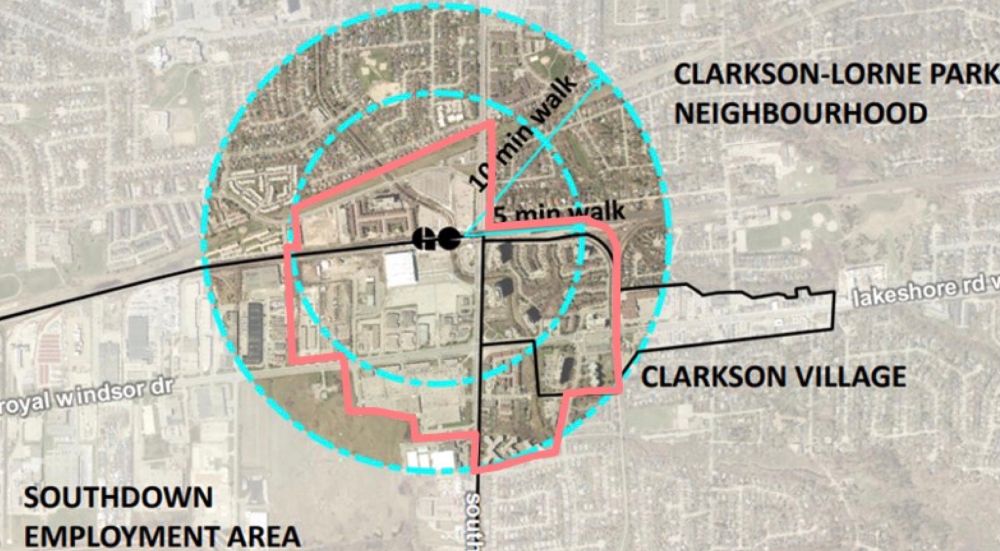
Mississauga’s updating its Clarkson GO station #MTSA policies to convert 10ha of irreplaceable employment lands for housing.
Why? Because they intentionally drew the boundary to exclude low-density “established neighbourhoods” of bungalows that are literally across the street from the station.
An air photo map of the Clarkson GO Station, showing 5 & 10 minute walks as circles, and a proposed major transit station area boundary as a pink line. The MTSA boundary cuts down Clarkson Road and then along the rail corridor, excluding all lands to the northeast of the station, which currently hold low-density neighbourhoods of single-family bungalows. Similarly, low-density bungalow neighbourhoods within a 5 minute walk north of the station’s parking lots are also excluded. Lands southeast of the station, containing apartment towers and townhouses are included within the boundary, as are the station’s parking lots and industrial areas to the southwest.
johnnyphenomic.bsky.social
That’s a “smaller increase” rather than a “decrease”, and noone’s arguing for growth in the red zone.

Why can’t you imagine total emissions going down? If a car-oriented area transitions to walkable, then both the current & future residents can walk. That decreases the current residents’ emissions.
johnnyphenomic.bsky.social
Then you misphrased your point. This wasn’t a dense area and it didn’t have the amenities until it was redeveloped. It changed a yellow area into a blue area.
johnnyphenomic.bsky.social
It’s not “evening out” population densities. It’s using intensification to pull key areas that are below a minimum threshold for walkability and frequent transit up to that threshold.

The real-world consequences are you displace a couple in a bungalow, rather than 60 people in walkup apartments.
johnnyphenomic.bsky.social
No to your claim that directing growth to blue zones can decrease total emissions.
Existing blue residents are low-emission so new neighbours won’t reduce their emissions, and existing red residents will stay high-emission without density-supported amenities, so total emissions can only go up.
johnnyphenomic.bsky.social
And the people in the yellow and orange zones will still drive a car everywhere (including the blue zones) because there’s not enough density to support their daily life within walking distance. While calling the Premier to complain about bike lanes & speed cameras in the blue zones.
johnnyphenomic.bsky.social
Take a look at Waterloo’s Northdale neighbourhood. It was all large-lot bungalows a decade or two ago, and is now well into its transformation to a dense, walkable and transit-supportive environment.

medium.com/@m_druker/ho...
How a Waterloo suburban neighbourhood is becoming urban
After trying everything else, Northdale embraces a wholesale transformation in its built form.
medium.com
johnnyphenomic.bsky.social
No. Directing population growth to the blue zones only reduces emissions per capita for the new residents.
Intensifying yellow zones to blue decreases emissions per capita for both the new residents and the existing residents, and even residents just beyond the area who can use new closer amenities.
johnnyphenomic.bsky.social
💯 It’s the survivorship bias problem.

The blue areas can be infilled but it won’t lower the region’s carbon footprint since they already have walkable/transit densities.

But infilling the yellow areas can tip them into that category, reducing carbon footprint for both new & existing residents.
A famous diagram used to illustrate survivorship bias, showing a WW2 plane with the location of damage received during a raid as red dots.
Counterintuitively, the red dots show where damage can be survived, while the clear areas show where any damage is fatal and improvements are therefore most needed.
Reposted by Wait, what?
johnnyphenomic.bsky.social
At what point do the lower courts start reissuing their decisions, noting that the only legal reasoning attached SCOTUS stays clearly states that this use of the emergency docket is illegitimate?
Reposted by Wait, what?
stephenjacobsmith.com
The circulation core of a mid-rise French apartment building is less than half the size of a mid-rise Canadian apartment building – 26.5 m^2 (285 sq. ft.) vs. 55 m^2 (592 sq. ft.)
Reposted by Wait, what?
alexdecampi.bsky.social
EMERGENCY TIMELINE CLEANSE: Godzilla says Trans Rights 🏳️‍⚧️
youtu.be/xG1T0URuTWw
johnnyphenomic.bsky.social
City. Region. Province. And country.
johnnyphenomic.bsky.social
Direct quote from this week’s Novae Res Urbis GTHA Edition (Vol.28, No.39):
“Going back to that delineation exercise, it was subtracting all the established low-rise neighbourhoods so they don’t count in the calculations that the Province has set out.”
johnnyphenomic.bsky.social
Mississauga’s updating its Clarkson GO station #MTSA policies to convert 10ha of irreplaceable employment lands for housing.
Why? Because they intentionally drew the boundary to exclude low-density “established neighbourhoods” of bungalows that are literally across the street from the station.
An air photo map of the Clarkson GO Station, showing 5 & 10 minute walks as circles, and a proposed major transit station area boundary as a pink line. The MTSA boundary cuts down Clarkson Road and then along the rail corridor, excluding all lands to the northeast of the station, which currently hold low-density neighbourhoods of single-family bungalows. Similarly, low-density bungalow neighbourhoods within a 5 minute walk north of the station’s parking lots are also excluded. Lands southeast of the station, containing apartment towers and townhouses are included within the boundary, as are the station’s parking lots and industrial areas to the southwest.
johnnyphenomic.bsky.social
“On average, very few Americans are illegally stopped, even fewer are detained more than once, and a negligible number are illegally detained six or more times. That ICE has done so to plaintiffs on a dozen occasions gives this court comfort that it is statistically unlikely it shall happen again.”
johnnyphenomic.bsky.social
Or requiring that the revenue be spent on road safety upgrades!
johnnyphenomic.bsky.social
Expanding the court isn’t enough at this point. These six have to be removed, and every single decision that relied on any of their votes to pass needs to be vacated all the way back to Thomas’ appointment in 1991.