Amateur Radio Operator KB9LXH
@kb9lxh.bsky.social
210 followers 61 following 51 posts
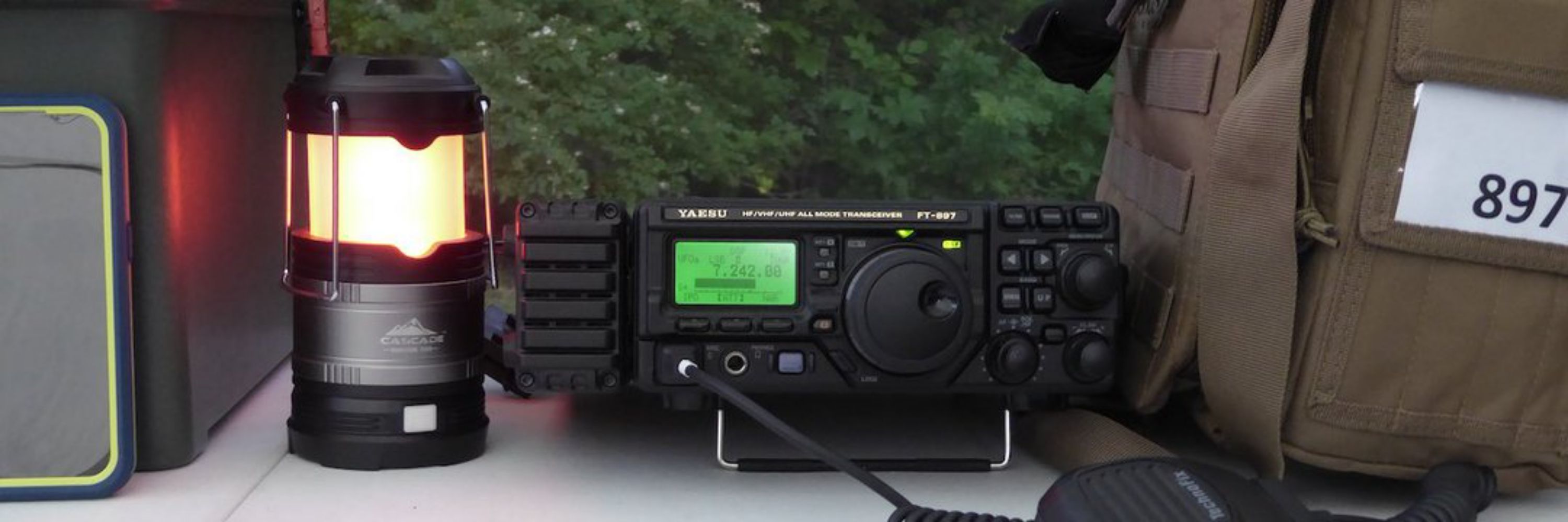
Amateur (ham) radio operator since 1981. Interests include AuxComm/EmComm support & SKYWARN spotting. Radio equipment includes a Yaesu FT-897D HF/VHF/UHF Xcvr, BTech UV-25X4 144/222/440 FM Mobile Xcvr, as well as several Dual and Tri-band HTs w/ antennas
Posts Media Videos Starter Packs
kb9lxh.bsky.social
Let's get the #HouseGOP, #HouseDemocrats, #SenateGOP and #SenateDems to pass the Amateur Radio Emergency Preparedness Act (It's H.R.1094 in the House and S.459 in the Senate). See 👇 on how #hamradio operators nationwide can help pass this bipartisan bill.
youtu.be/CxXh6Dh1-5o?...
Help Us Pass the Amateur Radio Emergency Preparedness Act
YouTube video by ARRLHQ
youtu.be
Reposted by Amateur Radio Operator KB9LXH
cocorahskyjc6.bsky.social
@jkl.nws-bot.us #JKL issued a Hazardous Weather Outlook (HWO) at 3:22 AM EDT on 24 Sep for Eastern Kentucky. Details 👉 at mesonet.agron.iastate.edu/wx/afos/p.ph... #ekywx #kywx #StormSpotters #StayWeatherAware
Reposted by Amateur Radio Operator KB9LXH
cocorahskyjc6.bsky.social
@sdf.nws-bot.us #LMK issued a Hazardous Weather Outlook (HWO) at 3:09 AM EDT on 24 Sep for Central Kentucky and Southern Indiana. Details 👉 at mesonet.agron.iastate.edu/wx/afos/p.ph... #kywx #inwx #StormSpotters #StayWeatherAware
Reposted by Amateur Radio Operator KB9LXH
cocorahskyjc6.bsky.social
Daily @cocorahskyjc6.bsky.social report for 24 Sep 2025 to #nwsjacksonky & #CoCoRaHS for #ekywx #DanielBooneNF & #kymesonet using #Logia7in1WiFi #PWS w/ a #CoCoRaHS-approved Rain gauge. This station's #wxdata can be found 24/7/365 at wunderground.com/pws/dashboar... #ShareYourWeather #BeWeatherAware
Reposted by Amateur Radio Operator KB9LXH
cocorahskyjc6.bsky.social
Rounds of showers and storms will continue today into tonight. A few storms may be strong to severe, especially across south central KY and there is a slight risk for excessive rainfall over Central and Eastern KY through tonight with additional rainfall forecast through late Thursday. #ekywx #kywx
kb9lxh.bsky.social
REMINDER*

WHAT: #APRSTHURSDAY net 

WHEN: 25-SEP-2025 00:00 - 23:59 UTC

HOW: Destination Station = ANSRVR 

HOW: Message body = CQ [space] HOTG [space] your message text.

#APRSTHURSDAY: The weekly net that fits everyone’s schedule.
Reposted by Amateur Radio Operator KB9LXH
cocorahskyjc6.bsky.social
The forecast across Central Kentucky and Southern Indiana calls for mostly dry conditions and warming temps through the end of the week and into the weekend. High will be 90 by Sat and Sun. There's a very small chc. of a sprinkle tonight into tomorrow but those chc. are low. Forecast weather.gov/lmk
Reposted by Amateur Radio Operator KB9LXH
cocorahskyjc6.bsky.social
High pressure will remain the dominant weather feature across Eastern Kentucky through early next week. Temperatures will gradually warm, reaching near to slightly above normal levels by Friday. No measurable rainfall is expected through early next week. #kywx #ekywx
Reposted by Amateur Radio Operator KB9LXH
cocorahskyjc6.bsky.social
Daily @cocorahskyjc6.bsky.social report for 10 Sep 2025 to #nwsjacksonky & #CoCoRaHS for #ekywx #DanielBooneNF & #kymesonet using #Logia7in1WiFi #PWS w/ a #CoCoRaHS-approved Rain gauge. This station's #wxdata can be found 24/7/365 at wunderground.com/pws/dashboar... #ShareYourWeather #BeWeatherAware
kb9lxh.bsky.social
*REMINDER*

WHAT: #APRSTHURSDAY net 

WHEN: 11-SEP-2025 00:00 - 23:59 UTC (or from 10-SEP 1900 to 11-SEP 1859 EDT)

HOW: Destination Station = ANSRVR 

HOW: Message body = CQ [space] HOTG [space] your message text.

#APRSTHURSDAY: The weekly net that fits everyone’s schedule.
kb9lxh.bsky.social
September is National Preparedness Month. Are you ready in case of an emergency? x.com/KB9LXH/statu...
kb9lxh.bsky.social
Atlanta based #HamRadio Usable HF Frequencies via hfpropagation.com
kb9lxh.bsky.social
Global Optimum NVIS Frequency Map Based Upon Hourly Ionosphere Soundings via sws.bom.gov.au/HF_Systems/6/5 #hamradio
kb9lxh.bsky.social
#HamRadio #APRS MSG from #KB9LXH-5 to #WA1GOV-10 #WXBOTCUR 5 mi. SSW Sandgap KY P. Cldy T 66.7F H 69% B 29.89inHg
Reposted by Amateur Radio Operator KB9LXH
allyblakewx.bsky.social
The peak of hurricane season is September 10th. We're not tracking ANYTHING in the Atlantic right now! A rare treat for this time of year. Enjoy it!
Reposted by Amateur Radio Operator KB9LXH
cocorahskyjc6.bsky.social
Daily @cocorahskyjc6.bsky.social report for 7 Sep 2025 to #nwsjacksonky & #CoCoRaHS for #ekywx #DanielBooneNF & #kymesonet using #Logia7in1WiFi #PWS w/ a #CoCoRaHS-approved Rain gauge. This station's #wxdata can be found 24/7/365 at wunderground.com/pws/dashboar... #ShareYourWeather #BeWeatherAware
Reposted by Amateur Radio Operator KB9LXH
cocorahskyjc6.bsky.social
@sdf.nws-bot.us #LMK issued a Hazardous Weather Outlook (HWO) at 6:32 AM EDT for Central Kentucky and Southern Indiana. Details 👉 at mesonet.agron.iastate.edu/wx/afos/p.ph... #kywx #inwx
Reposted by Amateur Radio Operator KB9LXH
cocorahskyjc6.bsky.social
@jkl.nws-bot.us #JKL issued a Hazardous Weather Outlook (HWO) at 3:18 AM EDT for Eastern Kentucky. Details 👉 at mesonet.agron.iastate.edu/wx/afos/p.ph... #ekywx #kywx
Reposted by Amateur Radio Operator KB9LXH
cocorahskyjc6.bsky.social
@sdf.nws-bot.us #LMK issued a Dense Fog Advisory for portions of East-Central and Southern Kentucky at 3:35 AM EDT, then updated the advisory at 5:07 AM CDT. Details 👉 at mesonet.agron.iastate.edu/vtec/?year=2... #BePrepared #StayWeatherAware #kywx
Reposted by Amateur Radio Operator KB9LXH
cocorahskyjc6.bsky.social
@jkl.nws-bot.us #JKL issued a Dense Fog Advisory till Sep 7, 10:00 AM EDT for Eastern Kentucky. Details 👉 at mesonet.agron.iastate.edu/vtec/?year=2... #ekywx #kywx
Reposted by Amateur Radio Operator KB9LXH
cocorahskyjc6.bsky.social
Due to widespread dense fog causing visibility to fall to 1/4 mile; a Dense Fog Advisory was issued for Eastern Kentucky by #JKL and is in effect until 10 AM this morning. #kywx #ekywx #BePrepared #StayWeatherAware
kb9lxh.bsky.social
WHAT: #APRSTHURSDAY net
WHEN: 04-SEP-2025 00:00 - 23:59 UTC
HOW: Set Destination Station = ANSRVR
HOW: Enter Message body = CQ [space] HOTG [space] your message text.

NOTE: APRSPH is undergoing some changes and may not be available for use this week.
Reposted by Amateur Radio Operator KB9LXH
kyulcminister.bsky.social
This is what true Christianity is supposed to look like!
Reposted by Amateur Radio Operator KB9LXH
nhc-epac.nws-bot.us
NHC Eastern North Pacific Outlook update for Tue, 02 Sep 2025 02:49:17 UTC
Additional Details Here.

ZCZC MIATWOEP ALL<br>TTAA00 KNHC DDHHMM<br><br>Tropical Weather Outlook<br>NWS National Hurricane Center Miami FL<br>500 PM PDT Mon Sep 1 2025<br><br>For the eastern and central North Pacific east of 180 longitude:<br><br>Active Systems: <br>The National Hurricane Center is issuing advisories on Tropical <br>Storm Kiko, located in the east Pacific basin well west-southwest <br>of the southern tip of the Baja California peninsula.  Kiko is <br>expected to cross into the central Pacific basin by the weekend.<br><br>1. South of Southwestern Mexico (EP94):<br>Showers and thunderstorms are becoming better organized in <br>association with a broad area of low pressure located a little more <br>than 100 miles off the coast of southwestern Mexico.  In addition, <br>earlier satellite-derived wind data indicate that winds to 35 mph <br>are occurring on its north side, close to the coast of Mexico.  This <br>system is expected to become a tropical depression or tropical storm <br>in the next day or so while it moves west-northwestward at 10 to 15 <br>mph off the coast of southwestern Mexico.  The disturbance is <br>expected to turn northwestward toward the Baja California peninsula <br>later in the week, and watches or warnings could be required for <br>portions of that area on Tuesday.  Regardless of development, heavy <br>rainfall is possible across coastal portions of southwestern and <br>west-central Mexico during the next few days, and these rains will <br>likely spread to Baja California Sur later in the week. The heavy <br>rains could lead to flash flooding, especially in mountainous areas.<br>* Formation chance through 48 hours...high...90 percent.<br>* Formation chance through 7 days...high...90 percent.<br><br><br><br>Forecaster Cangialosi<br><br><br>

Eastern North Pacific 2-Day Graphical Outlook Image Eastern North Pacific 7-Day Graphical Outlook Image
Reposted by Amateur Radio Operator KB9LXH
nhc-epac.nws-bot.us
Eastern North Pacific Tropical Depression Twelve-E Advisory Number 1 issued at Tue, 02 Sep 2025 02:42:42 +0000
...TROPICAL DEPRESSION FORMS TO THE SOUTH OF SOUTHWESTERN MEXICO...
Additional Details Here.

        000WTPZ32 KNHC 020242TCPEP2 BULLETINTropical Depression Twelve-E Advisory Number   1NWS National Hurricane Center Miami FL       EP122025900 PM CST Mon Sep 01 2025 ...TROPICAL DEPRESSION FORMS TO THE SOUTH OF SOUTHWESTERN MEXICO...  SUMMARY OF 900 PM CST...0300 UTC...INFORMATION----------------------------------------------LOCATION...17.2N 105.4WABOUT 145 MI...230 KM SSW OF MANZANILLO MEXICOMAXIMUM SUSTAINED WINDS...35 MPH...55 KM/HPRESENT MOVEMENT...WNW OR 295 DEGREES AT 14 MPH...22 KM/HMINIMUM CENTRAL PRESSURE...1007 MB...29.74 INCHES  WATCHES AND WARNINGS--------------------There are no coastal watches or warnings in effect.Interests in southwestern Mexico and Baja California Sur shouldmonitor the progress of this system.  A Tropical Storm Watch could be required for portions of Baja California Sur on Tuesday.  DISCUSSION AND OUTLOOK----------------------At 900 PM CST (0300 UTC), the center of Tropical Depression Twelve-Ewas located near latitude 17.2 North, longitude 105.4 West.  Thedepression is moving toward the west-northwest near 14 mph (22 km/h), and a gradual turn toward the northwest and north-northwest with a decrease in forward speed is expected over the next couple of days. Maximum sustained winds are near 35 mph (55 km/h) with higher gusts.Strengthening is forecast, and the system will likely become atropical storm on Tuesday.The estimated minimum central pressure is 1007 mb (29.74 inches).  HAZARDS AFFECTING LAND----------------------RAINFALL: Areas of heavy rainfall well east and northeast of the depression will continue to impact portions of northwestern Mexico from the states of Colima to Sinaloa tonight into Tuesday, with isolated flash flooding possible in areas of mountainous terrain.Bands of heavy rainfall are expected to begin impacting portions of Baja California Sur by Wednesday and persist through Friday. Rainfall totals of 4 to 8 inches are possible here, although there is uncertainty with these totals, and higher amounts are possible. Potentially significant flash flooding is a possibility depending on the track and strength of the system. NEXT ADVISORY-------------Next complete advisory at 300 AM CST. $$Forecaster Pasch
      Tropical Depression Twelve-E 5-Day Uncertainty Track Image Tropical Depression Twelve-E 34-Knot Wind Speed Probabilities