


Karen Capria 🦋
@kcapria.bsky.social
Maps, cartography, science.
The ArcGIS StoryMaps team is planning an excellent webinar that will help unpack the creative process for your stories. Explore, learn, and be inspired: storyscape-esriwhere.hub.arcgis.com/pages/commun...
#ArcGIS #storymaps #GIS #community
#ArcGIS #storymaps #GIS #community

March 28, 2025 at 9:05 PM
The ArcGIS StoryMaps team is planning an excellent webinar that will help unpack the creative process for your stories. Explore, learn, and be inspired: storyscape-esriwhere.hub.arcgis.com/pages/commun...
#ArcGIS #storymaps #GIS #community
#ArcGIS #storymaps #GIS #community
The collaboration between Taylor Guitars and UCLA’s Congo Basin Institute (CBI) demonstrates how partnerships working toward the greater good can be found, even in the unlikeliest of places. storymaps.arcgis.com/collections/... #ArcGIS #StoryMaps

January 28, 2025 at 4:58 PM
The collaboration between Taylor Guitars and UCLA’s Congo Basin Institute (CBI) demonstrates how partnerships working toward the greater good can be found, even in the unlikeliest of places. storymaps.arcgis.com/collections/... #ArcGIS #StoryMaps
Head to the Science & Environment Showcase at the Esri Federal GIS Conference to meet @deepseadawn.bsky.social, learn about her work, and get a signed copy of her book, Mapping the Deep. registration.esri.com/flow/esri/25... #GIS #mapping

January 27, 2025 at 3:30 PM
Head to the Science & Environment Showcase at the Esri Federal GIS Conference to meet @deepseadawn.bsky.social, learn about her work, and get a signed copy of her book, Mapping the Deep. registration.esri.com/flow/esri/25... #GIS #mapping
This Drought Aware app provides information on drought-affected areas in the US, and integrates critical information including population, housing, river flow, reservoirs, crops, and agricultural labor. livingatlas.arcgis.com/drought-awar... #GIS #LivingAtlas

January 24, 2025 at 4:26 PM
This Drought Aware app provides information on drought-affected areas in the US, and integrates critical information including population, housing, river flow, reservoirs, crops, and agricultural labor. livingatlas.arcgis.com/drought-awar... #GIS #LivingAtlas
Join Esri's Chief Scientist @deepseadawn.bsky.social for a free course on how a geographic approach can help tackle a complex changing climate. www.esri.com/training/cat... #GIS #EsriTraining

January 23, 2025 at 4:05 PM
Join Esri's Chief Scientist @deepseadawn.bsky.social for a free course on how a geographic approach can help tackle a complex changing climate. www.esri.com/training/cat... #GIS #EsriTraining
You can search on Genasys Protect for an address or mapped zone to determine if an area is under evacuation. protect.genasys.com/search?z=14&... #California #wildfires

January 9, 2025 at 6:11 PM
You can search on Genasys Protect for an address or mapped zone to determine if an area is under evacuation. protect.genasys.com/search?z=14&... #California #wildfires
New blog by Lisa Berry on authoritative historical fire perimeter data from the California Department of Forestry and Fire Protection (CAL FIRE).
CAL FIRE offers this digital record as a ready-to-use layer within ArcGIS Living Atlas of the World.
www.esri.com/arcgis-blog/... #GISchat
CAL FIRE offers this digital record as a ready-to-use layer within ArcGIS Living Atlas of the World.
www.esri.com/arcgis-blog/... #GISchat

December 6, 2024 at 9:44 PM
New blog by Lisa Berry on authoritative historical fire perimeter data from the California Department of Forestry and Fire Protection (CAL FIRE).
CAL FIRE offers this digital record as a ready-to-use layer within ArcGIS Living Atlas of the World.
www.esri.com/arcgis-blog/... #GISchat
CAL FIRE offers this digital record as a ready-to-use layer within ArcGIS Living Atlas of the World.
www.esri.com/arcgis-blog/... #GISchat
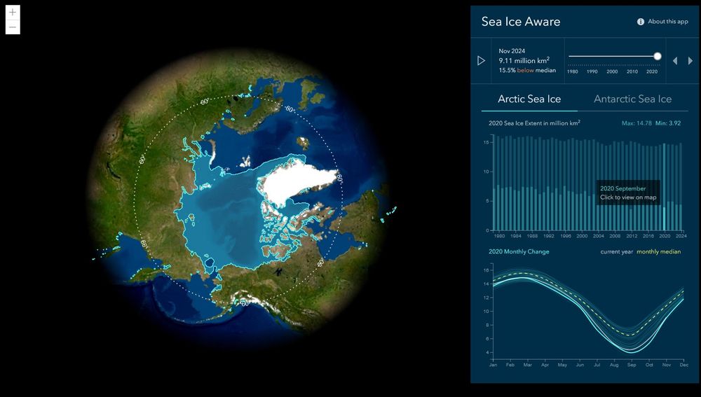
The Science— and joy — of snow and ice. Meet the people behind scientific expeditions and climate studies who inspire action to protect the landscapes we treasure.
Read the new issue of StoryScape from the ArcGIS StoryMaps team: storyscape-esriwhere.hub.arcgis.com #GISchat #science
Read the new issue of StoryScape from the ArcGIS StoryMaps team: storyscape-esriwhere.hub.arcgis.com #GISchat #science
December 5, 2024 at 6:30 PM
The Science— and joy — of snow and ice. Meet the people behind scientific expeditions and climate studies who inspire action to protect the landscapes we treasure.
Read the new issue of StoryScape from the ArcGIS StoryMaps team: storyscape-esriwhere.hub.arcgis.com #GISchat #science
Read the new issue of StoryScape from the ArcGIS StoryMaps team: storyscape-esriwhere.hub.arcgis.com #GISchat #science
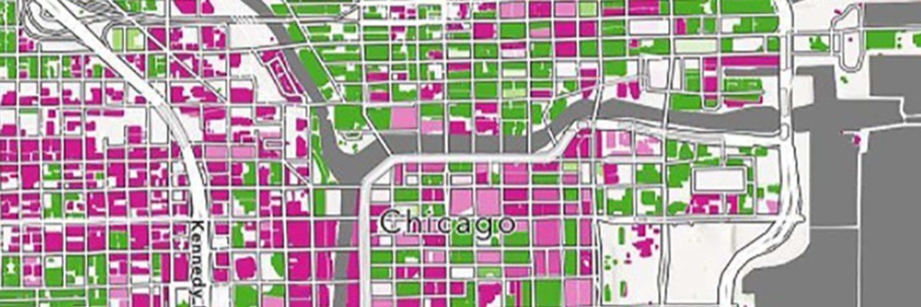
The ArcGIS Living Atlas Policy Mapping team provides the GIS community with a collection of free layers with data from the US Census Bureau’s American Community Survey.
On December 12, the US Census Bureau will release its updated five-year estimates (2019-2023). www.esri.com/arcgis-blog/... #GIS
On December 12, the US Census Bureau will release its updated five-year estimates (2019-2023). www.esri.com/arcgis-blog/... #GIS

December 5, 2024 at 2:32 PM
The ArcGIS Living Atlas Policy Mapping team provides the GIS community with a collection of free layers with data from the US Census Bureau’s American Community Survey.
On December 12, the US Census Bureau will release its updated five-year estimates (2019-2023). www.esri.com/arcgis-blog/... #GIS
On December 12, the US Census Bureau will release its updated five-year estimates (2019-2023). www.esri.com/arcgis-blog/... #GIS
PortWatch is an open platform designed to help policymakers and the public assess the impact of maritime trade disruptions that result from natural disasters or other large-scale events.
The platform is a collaboration between the IMF and the University of Oxford. portwatch.imf.org #GIS #climate
The platform is a collaboration between the IMF and the University of Oxford. portwatch.imf.org #GIS #climate

November 27, 2024 at 3:33 PM
PortWatch is an open platform designed to help policymakers and the public assess the impact of maritime trade disruptions that result from natural disasters or other large-scale events.
The platform is a collaboration between the IMF and the University of Oxford. portwatch.imf.org #GIS #climate
The platform is a collaboration between the IMF and the University of Oxford. portwatch.imf.org #GIS #climate
This course is free and provides practical techniques to elevate your spatial analysis. Sign up here: www.esri.com/training/cat... #Esri #GIS

November 25, 2024 at 7:32 PM
This course is free and provides practical techniques to elevate your spatial analysis. Sign up here: www.esri.com/training/cat... #Esri #GIS
Following up on the Esri Transit initiative launched in summer 2024, the release of the first-ever transit infographic is available in Esri’s Business Analyst Web App.
The data provided helps transit agencies understand the populations and destinations they serve. www.esri.com/arcgis-blog/...
The data provided helps transit agencies understand the populations and destinations they serve. www.esri.com/arcgis-blog/...

November 22, 2024 at 1:53 PM
Following up on the Esri Transit initiative launched in summer 2024, the release of the first-ever transit infographic is available in Esri’s Business Analyst Web App.
The data provided helps transit agencies understand the populations and destinations they serve. www.esri.com/arcgis-blog/...
The data provided helps transit agencies understand the populations and destinations they serve. www.esri.com/arcgis-blog/...
Explore GIS Day events around the world. www.gisday.com/en-us/overview #GISDay2024

November 17, 2024 at 6:17 PM
Explore GIS Day events around the world. www.gisday.com/en-us/overview #GISDay2024
GIS technology has changed the way we understand, navigate, and shape our world. Together, human creativity and technology can make a better future. www.esri.com/training/cat... #GIS

November 14, 2024 at 1:31 PM
GIS technology has changed the way we understand, navigate, and shape our world. Together, human creativity and technology can make a better future. www.esri.com/training/cat... #GIS
Learn how Python can help you automate ArcGIS workflows in a free live training seminar on December 12. Request a reminder: www.esri.com/training/cat... #Esri

October 31, 2024 at 7:44 PM
Learn how Python can help you automate ArcGIS workflows in a free live training seminar on December 12. Request a reminder: www.esri.com/training/cat... #Esri