


Kenneth Wong
@kennethkhw.bsky.social
Urbanist, Map nerd, GIS, #RStats
🔗 mappyurbanist.com
🔗 mappyurbanist.com
Pinned
Kenneth Wong
@kennethkhw.bsky.social
· Feb 24
Postmortem of my #30DayMapChallenge 2024 | Kenneth Wong - Cities and Maps
Behind the scenes of making the maps
mappyurbanist.com
Finally closing my 2024 #30DayMapChallenge! Wrote a blog summarising what I learned, the behind-the-scenes challenges faced, and the fun I had creating maps last Nov.
Check the blog and maps out here:
🗺️🔗 mappyurbanist.com/blog/2025-02...
#gischat
Check the blog and maps out here:
🗺️🔗 mappyurbanist.com/blog/2025-02...
#gischat
Hi all urbanists here: I will be visiting Australia (Sydney and Melbourne) shortly, are there any transport planning / active travel / architecture / urban planning projects you'd recommend for a site visit?
November 19, 2025 at 5:35 PM
Hi all urbanists here: I will be visiting Australia (Sydney and Melbourne) shortly, are there any transport planning / active travel / architecture / urban planning projects you'd recommend for a site visit?
Reposted by Kenneth Wong

See my commentary in @nytimes.com in re climatic & non-climatic factors pushing down home prices (always excellent work of @benkeys.bsky.social & P. Mulder) Amazing to see how far prices have tanked in Nola. Good News: homes w/ Fortified Roofs are holding their value. www.nytimes.com/interactive/...

Rising Home Insurance Premiums Are Eating Into Home Values in Disaster-Prone Areas (Gift Article)
Changes in the insurance market have started to affect home prices in the most disaster-prone areas, new research finds, pushing some homeowners’ finances to the breaking point.
www.nytimes.com
November 19, 2025 at 12:51 PM
See my commentary in @nytimes.com in re climatic & non-climatic factors pushing down home prices (always excellent work of @benkeys.bsky.social & P. Mulder) Amazing to see how far prices have tanked in Nola. Good News: homes w/ Fortified Roofs are holding their value. www.nytimes.com/interactive/...
#30DayMapChallenge Day 19 - Projections
19 projected coordinate systems of Japan (JGD2011 Japan plane rectangular CS, I to XIX) shown together, with Tokyo being the centre point
Don’t ask me what does this map means, I also have no idea what I’m doing
19 projected coordinate systems of Japan (JGD2011 Japan plane rectangular CS, I to XIX) shown together, with Tokyo being the centre point
Don’t ask me what does this map means, I also have no idea what I’m doing

November 19, 2025 at 2:51 PM
#30DayMapChallenge Day 19 - Projections
19 projected coordinate systems of Japan (JGD2011 Japan plane rectangular CS, I to XIX) shown together, with Tokyo being the centre point
Don’t ask me what does this map means, I also have no idea what I’m doing
19 projected coordinate systems of Japan (JGD2011 Japan plane rectangular CS, I to XIX) shown together, with Tokyo being the centre point
Don’t ask me what does this map means, I also have no idea what I’m doing
#30DayMapChallenge Day 17 - A new tool
Testing out the {mapgl} package in #RStats with a zoom-in animation on Shibuya station, Tokyo
The highlighted zones show 10-minute walking isochrones from each Yamanote Line station made for the previous map
Testing out the {mapgl} package in #RStats with a zoom-in animation on Shibuya station, Tokyo
The highlighted zones show 10-minute walking isochrones from each Yamanote Line station made for the previous map
November 18, 2025 at 2:41 PM
#30DayMapChallenge Day 17 - A new tool
Testing out the {mapgl} package in #RStats with a zoom-in animation on Shibuya station, Tokyo
The highlighted zones show 10-minute walking isochrones from each Yamanote Line station made for the previous map
Testing out the {mapgl} package in #RStats with a zoom-in animation on Shibuya station, Tokyo
The highlighted zones show 10-minute walking isochrones from each Yamanote Line station made for the previous map
#30DayMapChallenge Day 13 - 10 minute map
Reachable areas within a 10-minute walk / 10-min isochrones of Yamanote Line (山手線) stations
And yes, the map took much longer than 10 mins to make, sorry not sorry
Reachable areas within a 10-minute walk / 10-min isochrones of Yamanote Line (山手線) stations
And yes, the map took much longer than 10 mins to make, sorry not sorry

November 13, 2025 at 3:29 PM
#30DayMapChallenge Day 13 - 10 minute map
Reachable areas within a 10-minute walk / 10-min isochrones of Yamanote Line (山手線) stations
And yes, the map took much longer than 10 mins to make, sorry not sorry
Reachable areas within a 10-minute walk / 10-min isochrones of Yamanote Line (山手線) stations
And yes, the map took much longer than 10 mins to make, sorry not sorry

November 11, 2025 at 11:06 AM
#30DayMapChallenge Day 8 - Urban
Betweenness centrality of the pedestrian network within 2 km of selected Taiwan's train Stations (Taipei, Taichung, Kaohsiung)
Warming up with OSMnx again
Betweenness centrality of the pedestrian network within 2 km of selected Taiwan's train Stations (Taipei, Taichung, Kaohsiung)
Warming up with OSMnx again

November 9, 2025 at 5:53 PM
#30DayMapChallenge Day 8 - Urban
Betweenness centrality of the pedestrian network within 2 km of selected Taiwan's train Stations (Taipei, Taichung, Kaohsiung)
Warming up with OSMnx again
Betweenness centrality of the pedestrian network within 2 km of selected Taiwan's train Stations (Taipei, Taichung, Kaohsiung)
Warming up with OSMnx again
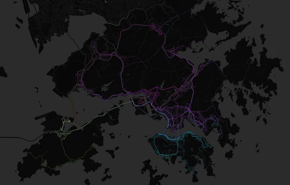
#30DayMapChallenge Day 6 - Dimensions
Pseudo-3D / 2.5D “axonometric” site plans of several districts in Hong Kong (Wan Chai, Kwun Tong, Tsuen Wan)
Pseudo-3D / 2.5D “axonometric” site plans of several districts in Hong Kong (Wan Chai, Kwun Tong, Tsuen Wan)


November 7, 2025 at 5:02 AM
#30DayMapChallenge Day 6 - Dimensions
Pseudo-3D / 2.5D “axonometric” site plans of several districts in Hong Kong (Wan Chai, Kwun Tong, Tsuen Wan)
Pseudo-3D / 2.5D “axonometric” site plans of several districts in Hong Kong (Wan Chai, Kwun Tong, Tsuen Wan)
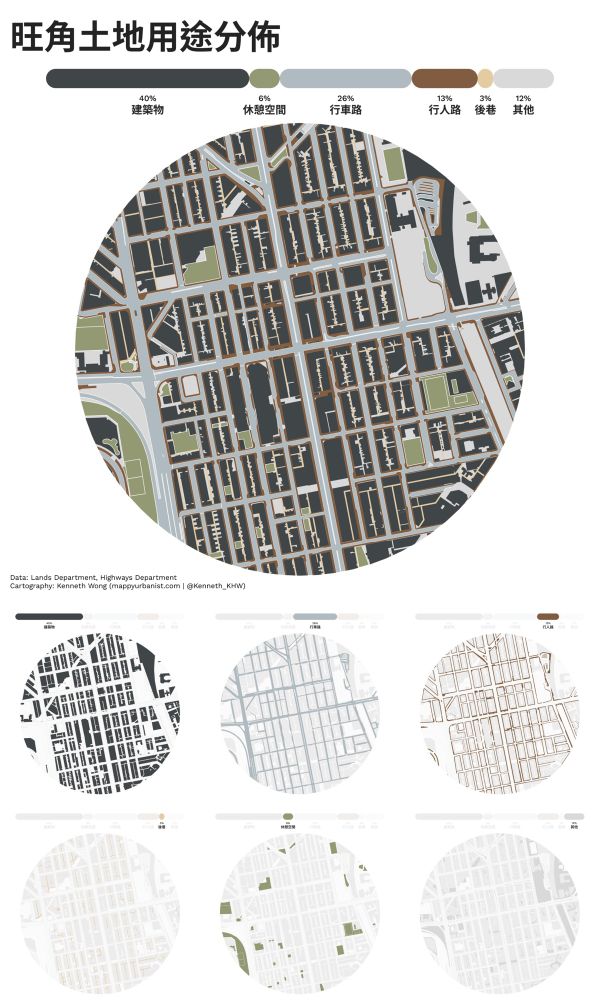
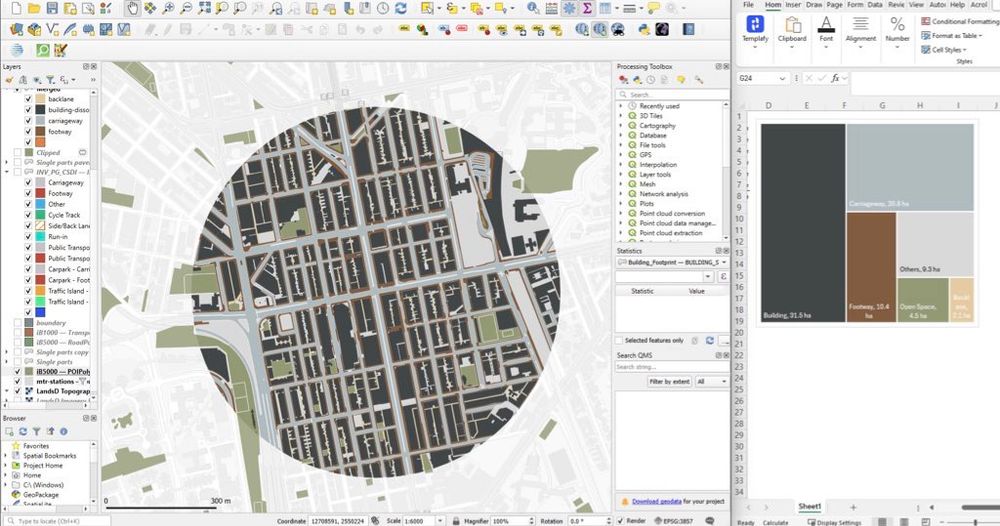
#30DayMapChallenge Day 3 - Polygons
Land use distribution of Mong Kok, Hong Kong
Classified into 6 major categories: built structure, open space, carriageway, footway, alleyway, others
Land use distribution of Mong Kok, Hong Kong
Classified into 6 major categories: built structure, open space, carriageway, footway, alleyway, others

November 3, 2025 at 3:06 PM
#30DayMapChallenge Day 3 - Polygons
Land use distribution of Mong Kok, Hong Kong
Classified into 6 major categories: built structure, open space, carriageway, footway, alleyway, others
Land use distribution of Mong Kok, Hong Kong
Classified into 6 major categories: built structure, open space, carriageway, footway, alleyway, others

November 2, 2025 at 12:38 PM

October 31, 2025 at 4:36 PM
*Some ffmpeg command testing*

June 12, 2025 at 4:28 AM
*Some ffmpeg command testing*
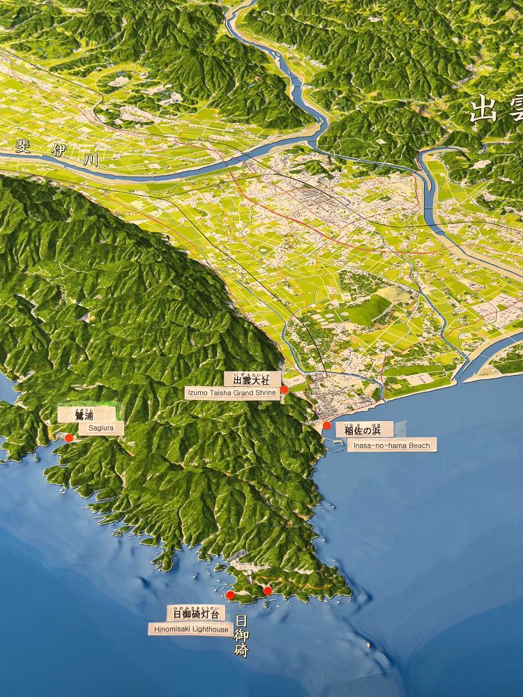
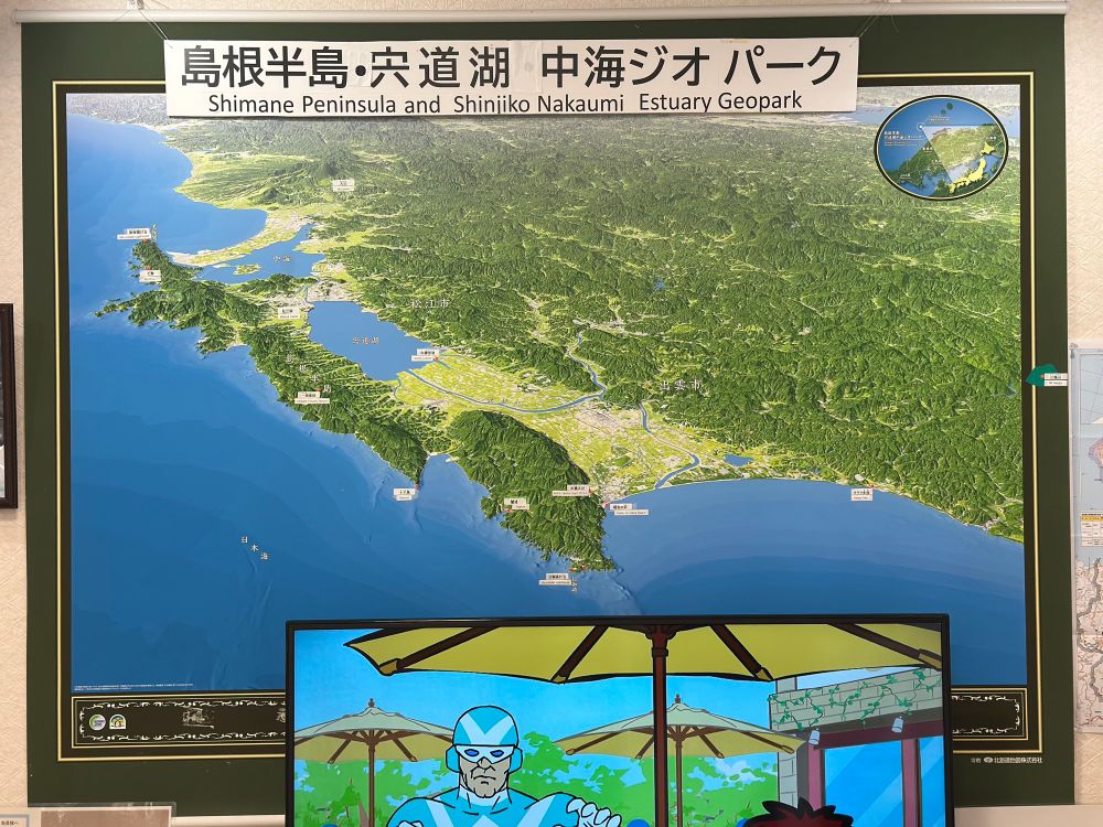
#MapsInTheWild Axonometric map of the Shimane Peninsula at the visitor centre of Hinomisaki Lighthouse
Stunning greenish hillshades and subtle ocean depth bluish gradients 🌊⛰️🗾
Stunning greenish hillshades and subtle ocean depth bluish gradients 🌊⛰️🗾
June 9, 2025 at 4:40 AM
#MapsInTheWild Axonometric map of the Shimane Peninsula at the visitor centre of Hinomisaki Lighthouse
Stunning greenish hillshades and subtle ocean depth bluish gradients 🌊⛰️🗾
Stunning greenish hillshades and subtle ocean depth bluish gradients 🌊⛰️🗾
Back to a #QGIS #cartography project of mapping land use distribution in Mong Kok, Hong Kong by breaking down land into 6 key categories.
Together with small multiples showing area of: built structure, carriageway, footway, back-lane, open space, and others
Together with small multiples showing area of: built structure, carriageway, footway, back-lane, open space, and others
May 26, 2025 at 1:25 PM
Back to a #QGIS #cartography project of mapping land use distribution in Mong Kok, Hong Kong by breaking down land into 6 key categories.
Together with small multiples showing area of: built structure, carriageway, footway, back-lane, open space, and others
Together with small multiples showing area of: built structure, carriageway, footway, back-lane, open space, and others
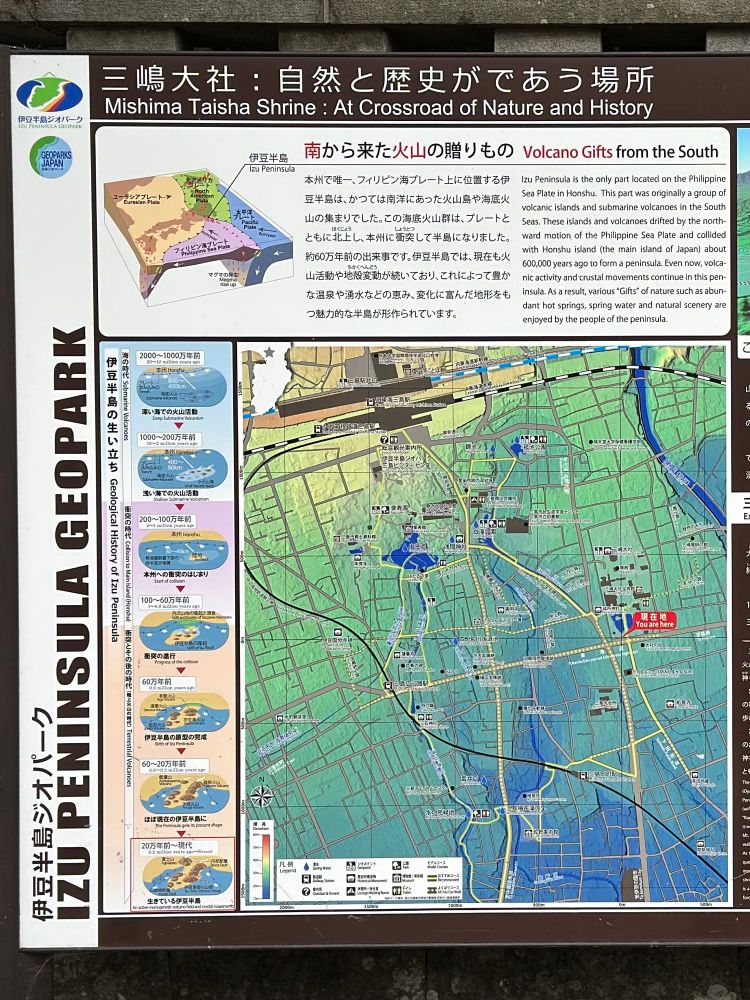
#MapsInTheWild Topography of Izu Pensisula with illustrations of plate tectonics of the area in Mishima, Shizuoka 🌋🗻
Brings me back the vibes of old high school geography textbook
Brings me back the vibes of old high school geography textbook
April 29, 2025 at 8:26 PM
#MapsInTheWild Topography of Izu Pensisula with illustrations of plate tectonics of the area in Mishima, Shizuoka 🌋🗻
Brings me back the vibes of old high school geography textbook
Brings me back the vibes of old high school geography textbook
Release of QGIS 4 is undoubtedly exciting news - I still remember the huge UI/UX leap when upgrading from QGIS v2 to v3 on my Mac somewhere in 2019 🚀
#gischat
blog.qgis.org/2025/04/17/q...
#gischat
blog.qgis.org/2025/04/17/q...

🎉 Big Changes Ahead: QGIS Is Moving to Qt6 and Launching QGIS 4.0!
Exciting times are ahead for the QGIS project! We’re thrilled to share some major updates coming to the QGIS platform over the next few months. These changes are part of a long-planned technical mi…
blog.qgis.org
April 18, 2025 at 6:19 PM
Release of QGIS 4 is undoubtedly exciting news - I still remember the huge UI/UX leap when upgrading from QGIS v2 to v3 on my Mac somewhere in 2019 🚀
#gischat
blog.qgis.org/2025/04/17/q...
#gischat
blog.qgis.org/2025/04/17/q...
Working on bus route data and got distracted into playing with line symbology again #MapInProgress
April 15, 2025 at 5:57 PM
Working on bus route data and got distracted into playing with line symbology again #MapInProgress
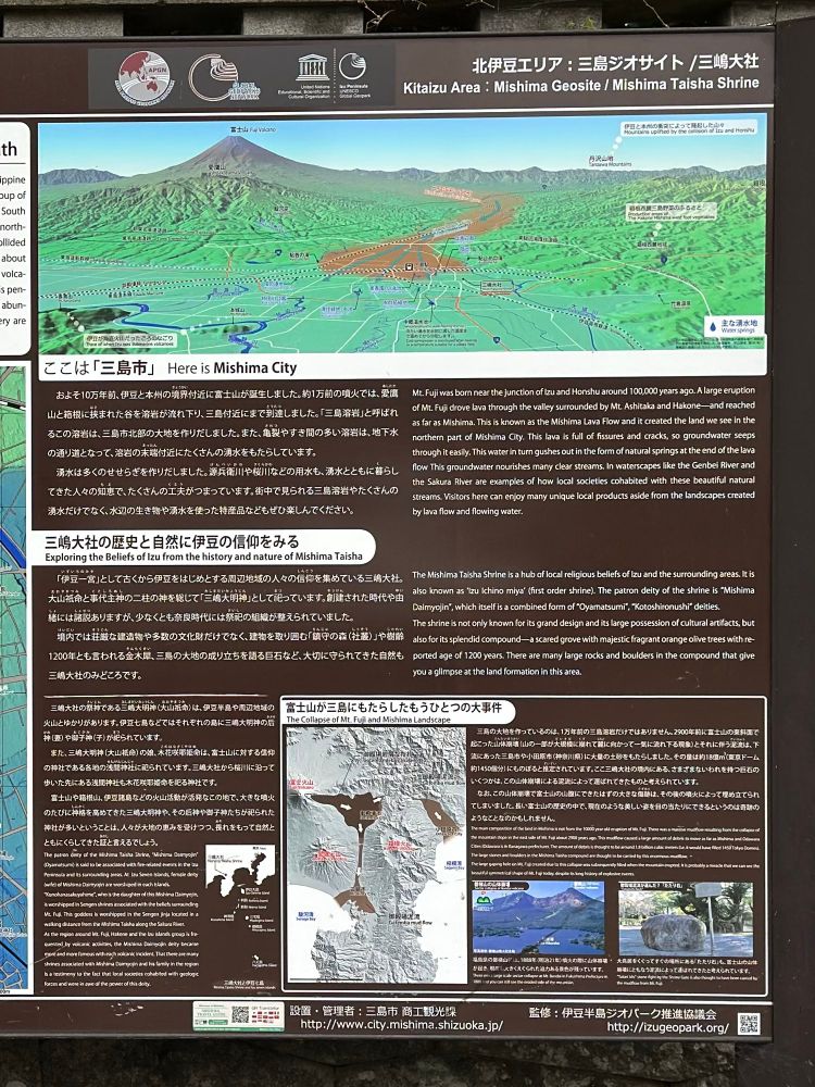
#MapsInTheWild a detailed illustration of Mount Fuji’s surrounding areas 🗻
Found this map at Mishima Taisha Shrine. The deeper you explore the map, the more intricate details you could uncover
Found this map at Mishima Taisha Shrine. The deeper you explore the map, the more intricate details you could uncover
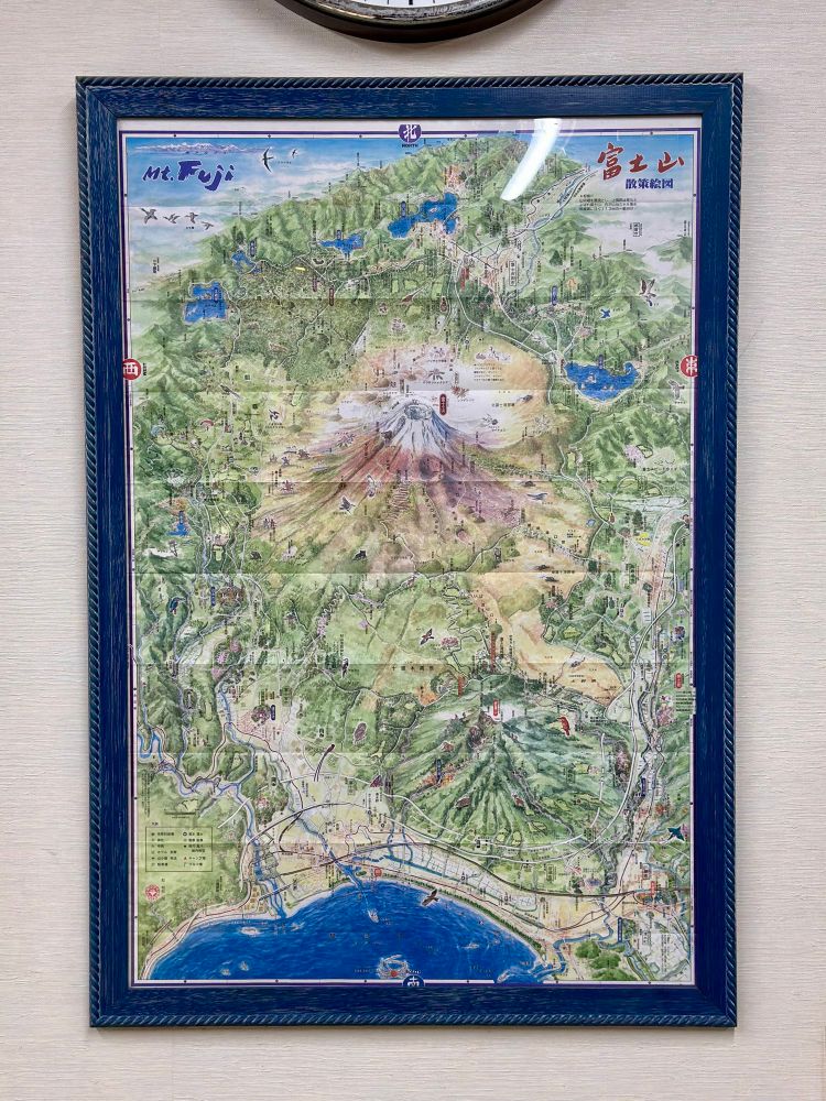
April 9, 2025 at 2:48 PM
#MapsInTheWild a detailed illustration of Mount Fuji’s surrounding areas 🗻
Found this map at Mishima Taisha Shrine. The deeper you explore the map, the more intricate details you could uncover
Found this map at Mishima Taisha Shrine. The deeper you explore the map, the more intricate details you could uncover

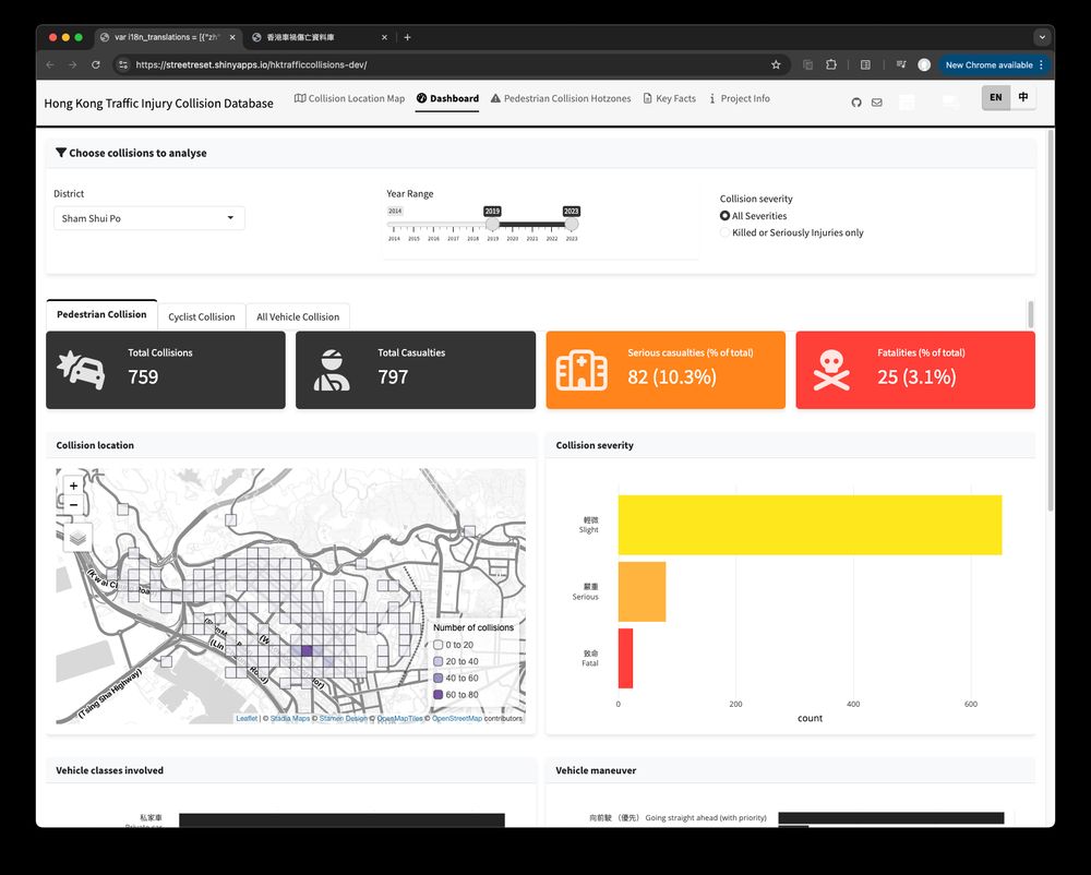
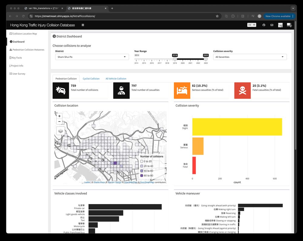
Asked Cursor with Claude 3.7 to give my #RStats shiny app a facelift by switching {shinydashboard} to {bslib}
Spent an extra day to fix the broken bits, tweak the flows and polish the UI - but it’s still slick that I even have no idea where to start without Claude
Spent an extra day to fix the broken bits, tweak the flows and polish the UI - but it’s still slick that I even have no idea where to start without Claude
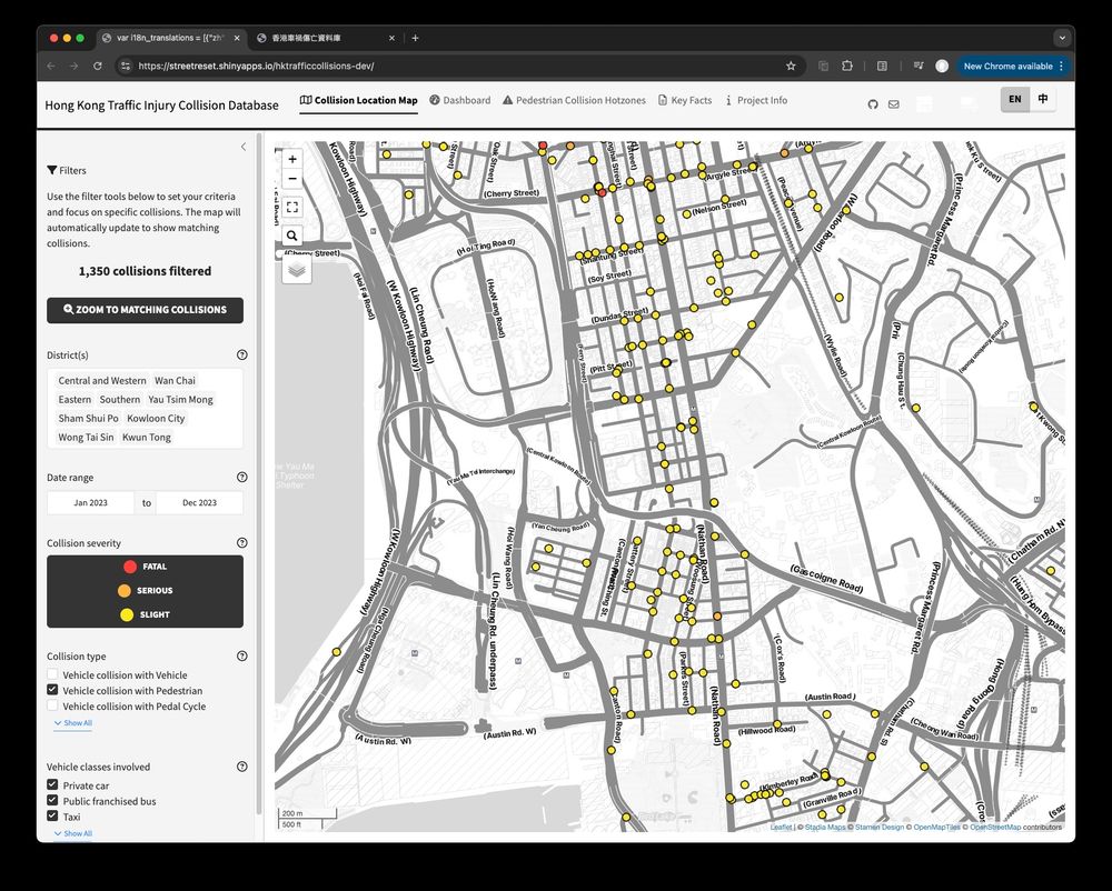
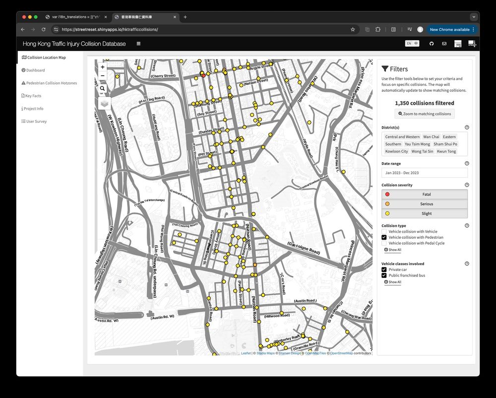
March 5, 2025 at 4:19 PM
Asked Cursor with Claude 3.7 to give my #RStats shiny app a facelift by switching {shinydashboard} to {bslib}
Spent an extra day to fix the broken bits, tweak the flows and polish the UI - but it’s still slick that I even have no idea where to start without Claude
Spent an extra day to fix the broken bits, tweak the flows and polish the UI - but it’s still slick that I even have no idea where to start without Claude
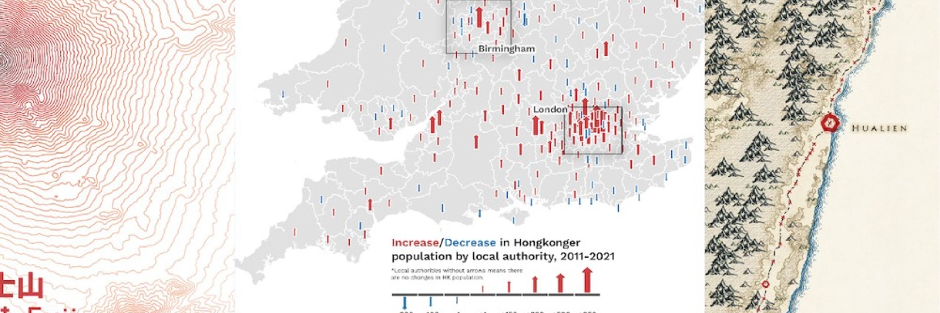
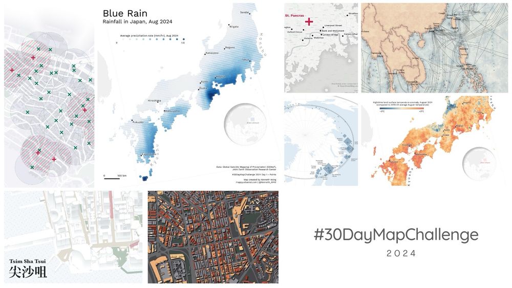
Finally closing my 2024 #30DayMapChallenge! Wrote a blog summarising what I learned, the behind-the-scenes challenges faced, and the fun I had creating maps last Nov.
Check the blog and maps out here:
🗺️🔗 mappyurbanist.com/blog/2025-02...
#gischat
Check the blog and maps out here:
🗺️🔗 mappyurbanist.com/blog/2025-02...
#gischat
Postmortem of my #30DayMapChallenge 2024 | Kenneth Wong - Cities and Maps
Behind the scenes of making the maps
mappyurbanist.com
February 24, 2025 at 6:08 PM
Finally closing my 2024 #30DayMapChallenge! Wrote a blog summarising what I learned, the behind-the-scenes challenges faced, and the fun I had creating maps last Nov.
Check the blog and maps out here:
🗺️🔗 mappyurbanist.com/blog/2025-02...
#gischat
Check the blog and maps out here:
🗺️🔗 mappyurbanist.com/blog/2025-02...
#gischat
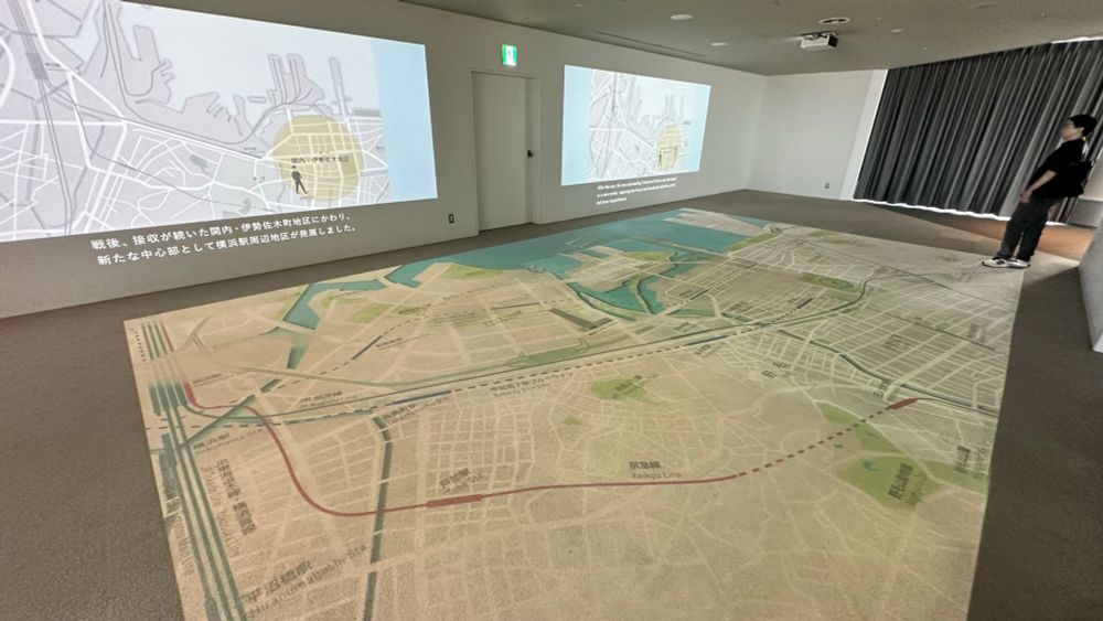
#MapsInTheWild a giant map of Yokohama on Yokohama Landmark Tower’s observation deck
An enormous map spreading out the floor is always a cool thing to me
An enormous map spreading out the floor is always a cool thing to me
February 19, 2025 at 4:28 PM
#MapsInTheWild a giant map of Yokohama on Yokohama Landmark Tower’s observation deck
An enormous map spreading out the floor is always a cool thing to me
An enormous map spreading out the floor is always a cool thing to me
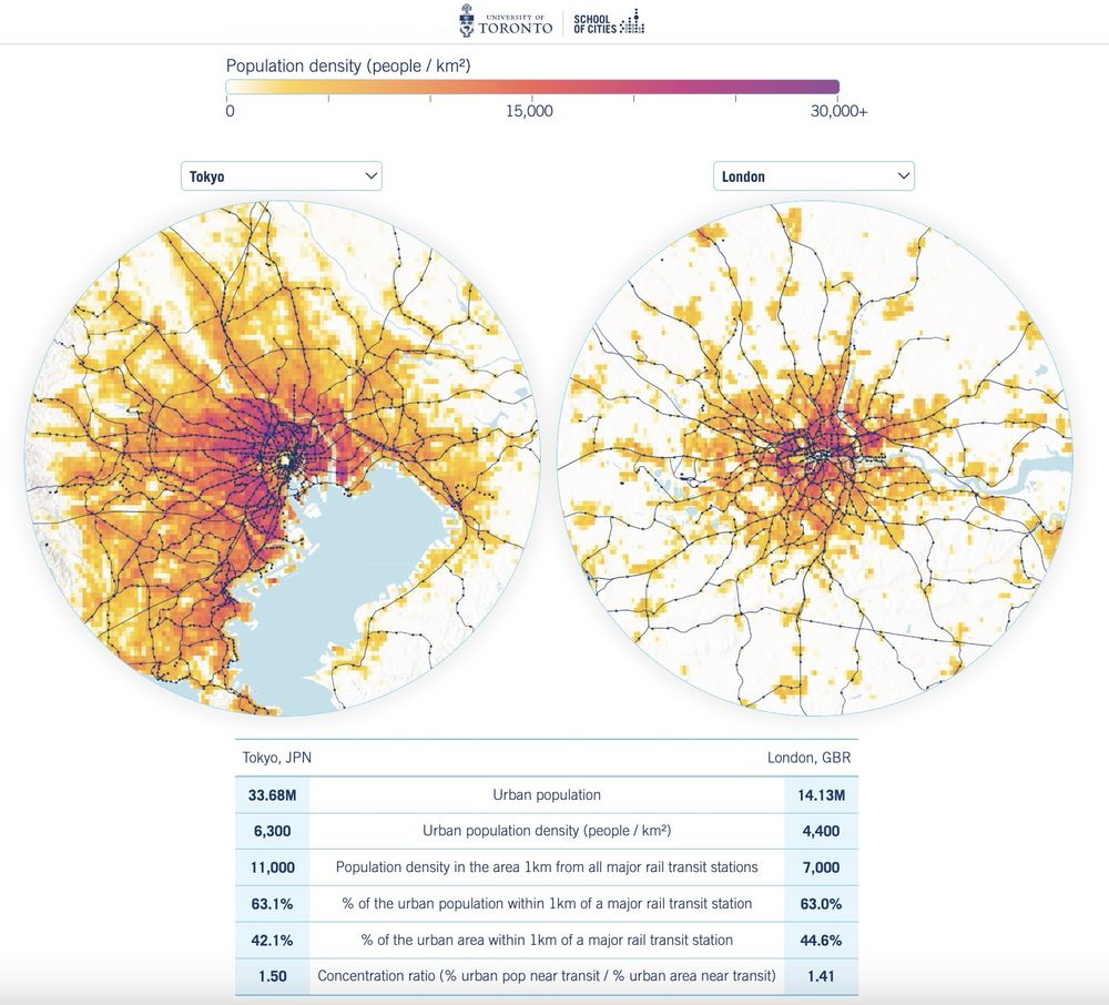
Calling all map/urban/railway nerds to check out this website visualising railway accessibility across 250 cities around the globe by Aniket Kali and @jamaps.bsky.social - stunning #cartography and #dataviz
🔗 schoolofcities.github.io/rail-transit...
#gischat
🔗 schoolofcities.github.io/rail-transit...
#gischat
February 12, 2025 at 4:46 PM
Calling all map/urban/railway nerds to check out this website visualising railway accessibility across 250 cities around the globe by Aniket Kali and @jamaps.bsky.social - stunning #cartography and #dataviz
🔗 schoolofcities.github.io/rail-transit...
#gischat
🔗 schoolofcities.github.io/rail-transit...
#gischat
#30DayMapChallenge Day 16 - Choropleth
Interactive map of median household income distribution in Hong Kong, made with #RStats
Challenging myself to create a non-static and non-QGIS map, despite a late submission 🤐
#RSpatial
Interactive map of median household income distribution in Hong Kong, made with #RStats
Challenging myself to create a non-static and non-QGIS map, despite a late submission 🤐
#RSpatial
February 5, 2025 at 4:56 PM
#30DayMapChallenge Day 16 - Choropleth
Interactive map of median household income distribution in Hong Kong, made with #RStats
Challenging myself to create a non-static and non-QGIS map, despite a late submission 🤐
#RSpatial
Interactive map of median household income distribution in Hong Kong, made with #RStats
Challenging myself to create a non-static and non-QGIS map, despite a late submission 🤐
#RSpatial