


Landsat 🛰️
@landsat.bsky.social
🛰️📡 Unofficial mirror/fan account for the Landsat Program, a series of Earth-observing satellites co-managed by USGS & NASA, imaging the Earth since 1972. Posts do not necessarily reflect the views of USGS or NASA.
Remembering its quarter-century of faithful Earth observation, the USGS and NASA have announced the decommissioning of Landsat 7 from active service. Landsat 8 and Landsat 9 continue to collect images every day. Read more about Landsat 7: ow.ly/nz9k50W5CAQ

June 16, 2025 at 6:03 PM
Remembering its quarter-century of faithful Earth observation, the USGS and NASA have announced the decommissioning of Landsat 7 from active service. Landsat 8 and Landsat 9 continue to collect images every day. Read more about Landsat 7: ow.ly/nz9k50W5CAQ
#Landsat 8 collected new images of these Canada fires on June 5, 2025. Image A shows a wildfire near the Petitot River in northeastern British Columbia. The Saskatchewan fire in image B is burning east of Mari Lake. More than 200 fires are currently active across Canada.
June 9, 2025 at 4:56 AM
#Landsat 8 collected new images of these Canada fires on June 5, 2025. Image A shows a wildfire near the Petitot River in northeastern British Columbia. The Saskatchewan fire in image B is burning east of Mari Lake. More than 200 fires are currently active across Canada.
🌎🛰️After 25 years of Earth observation, the USGS bid farewell to #Landsat 7 on June 4, 2025. The legacy continues with Landsat 8 and 9, capturing planetary imagery to support global communities.
👉 ow.ly/ZTf150W4mp3
👉 ow.ly/ZTf150W4mp3


June 5, 2025 at 2:32 PM
🌎🛰️After 25 years of Earth observation, the USGS bid farewell to #Landsat 7 on June 4, 2025. The legacy continues with Landsat 8 and 9, capturing planetary imagery to support global communities.
👉 ow.ly/ZTf150W4mp3
👉 ow.ly/ZTf150W4mp3
Fallow farmland is the main source of human-caused dust storms in California’s Central Valley region, according to a new study using data from NASA and others. From 2008-2022, 88% of major human-caused dust events were associated with fallow land.


June 3, 2025 at 3:50 AM
Fallow farmland is the main source of human-caused dust storms in California’s Central Valley region, according to a new study using data from NASA and others. From 2008-2022, 88% of major human-caused dust events were associated with fallow land.
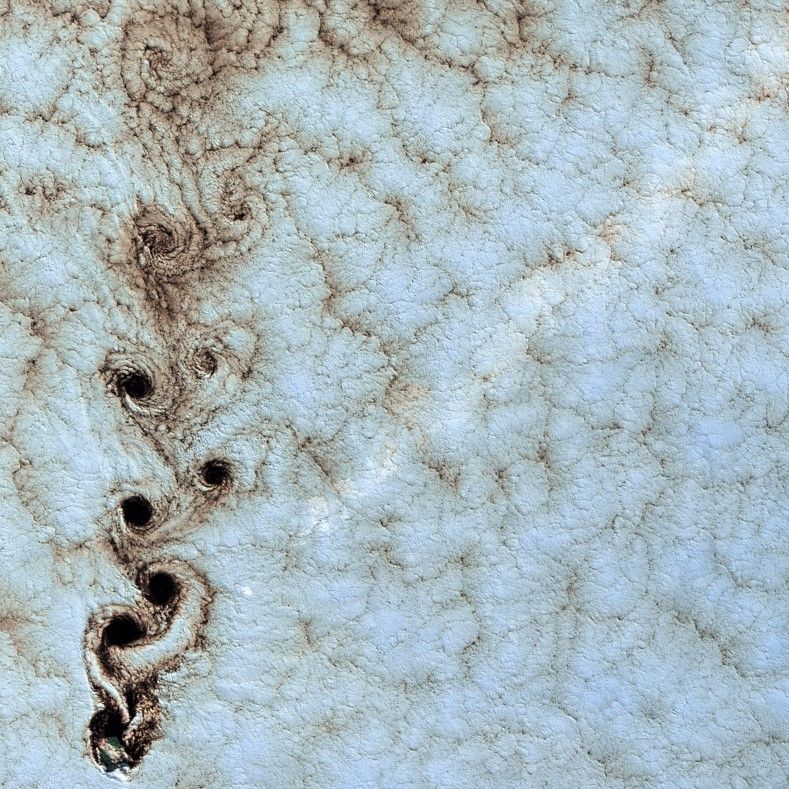
What might be mistaken for dinosaur bones being unearthed at a paleontological dig are some of the individual reefs that make up the #GreatBarrierReef. Download the image here: ow.ly/6xl250S4wG2.

June 3, 2025 at 3:47 AM
What might be mistaken for dinosaur bones being unearthed at a paleontological dig are some of the individual reefs that make up the #GreatBarrierReef. Download the image here: ow.ly/6xl250S4wG2.
#Landsat 9 captured imagery of an area in southern Switzerland that was devastated by a landslide on May 28th caused by partial glacier collapse. These natural color panchromatic-sharpened images show the area on May 13th, and again on May 29th.
May 31, 2025 at 12:49 PM
#Landsat 9 captured imagery of an area in southern Switzerland that was devastated by a landslide on May 28th caused by partial glacier collapse. These natural color panchromatic-sharpened images show the area on May 13th, and again on May 29th.

May 30, 2025 at 7:26 AM
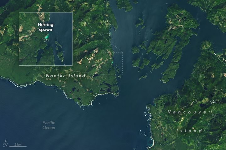
This is near Vancouver Island in British Columbia, Canada. And see that blue glow? That’s a herring spawn! Every spring, thousands of Pacific herring congregate in shallow, vegetated coastal areas around this area to spawn, like in this #Landsat 8 image from April 27.
(via NASA Earth)
(via NASA Earth)
May 29, 2025 at 6:16 AM
This is near Vancouver Island in British Columbia, Canada. And see that blue glow? That’s a herring spawn! Every spring, thousands of Pacific herring congregate in shallow, vegetated coastal areas around this area to spawn, like in this #Landsat 8 image from April 27.
(via NASA Earth)
(via NASA Earth)
Landsat satellites captured imagery of active fires in north-central Saskatchewan, described by the Saskatchewan Public Safety Agency as the “busiest, most active fire level” this early in the season. Future #Landsat data will help assess landscape impacts.
May 29, 2025 at 6:12 AM
Landsat satellites captured imagery of active fires in north-central Saskatchewan, described by the Saskatchewan Public Safety Agency as the “busiest, most active fire level” this early in the season. Future #Landsat data will help assess landscape impacts.
Landsat images reveal the trails of ship traffic in major U.S. ports and harbors. Over 10 years of cloud-free imagery and the #Landsat panchromatic band were used to create these images.
May 29, 2025 at 6:10 AM
Landsat images reveal the trails of ship traffic in major U.S. ports and harbors. Over 10 years of cloud-free imagery and the #Landsat panchromatic band were used to create these images.
The GOLD standard is the goal of the USGS EROS CalVal Center of Excellence #Landsat Cal/Val team. Experts focus on improving the accuracy, precision, calibration, & quality of data acquired by active Landsat missions publish their findings in reports: ow.ly/GH4J50VruLS

May 29, 2025 at 6:08 AM
The GOLD standard is the goal of the USGS EROS CalVal Center of Excellence #Landsat Cal/Val team. Experts focus on improving the accuracy, precision, calibration, & quality of data acquired by active Landsat missions publish their findings in reports: ow.ly/GH4J50VruLS
Landsat could use your support. The mission's 50+ year data continuity is at risk. If you believe contacting elected representatives does anything, now would be a good time to apply pressure. 🛰️📡
May 7, 2025 at 4:01 AM
Landsat could use your support. The mission's 50+ year data continuity is at risk. If you believe contacting elected representatives does anything, now would be a good time to apply pressure. 🛰️📡
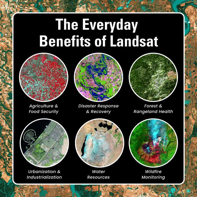
For 50+ years, #Landsat 🛰️ has captured the changing face of Earth, creating an #EarthObservation record that continues to provide countless #SocietalBenefits. How has Landsat benefited your community?
#gischat #eochat
ow.ly/oPQ050VBGwx
#gischat #eochat
ow.ly/oPQ050VBGwx
April 19, 2025 at 3:33 AM
For 50+ years, #Landsat 🛰️ has captured the changing face of Earth, creating an #EarthObservation record that continues to provide countless #SocietalBenefits. How has Landsat benefited your community?
#gischat #eochat
ow.ly/oPQ050VBGwx
#gischat #eochat
ow.ly/oPQ050VBGwx
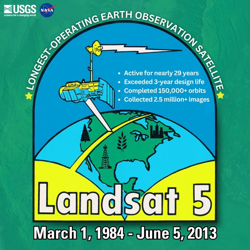
#OTD in 1984, #Landsat 5 was launched into space. Far exceeding its three-year design life, Landsat 5 set a #GuinnessWorldRecord for the “Longest-operating #EarthObservation satellite.” Its longevity ensured a continuous stream of data that kept the Landsat archive intact. 🛰️🌎
March 1, 2025 at 7:00 PM
#OTD in 1984, #Landsat 5 was launched into space. Far exceeding its three-year design life, Landsat 5 set a #GuinnessWorldRecord for the “Longest-operating #EarthObservation satellite.” Its longevity ensured a continuous stream of data that kept the Landsat archive intact. 🛰️🌎
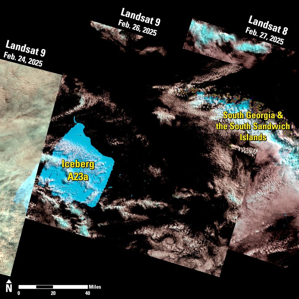
Iceberg A23a is drawing significant attention as it drifts toward South Georgia and the South Sandwich Islands. A #Landsat 9 image from Feb. 26 shows it roughly 50 nautical miles from the remote islands. Learn more about the journey of A23a here: ow.ly/Cz4950V7XVl
February 28, 2025 at 12:39 AM
Iceberg A23a is drawing significant attention as it drifts toward South Georgia and the South Sandwich Islands. A #Landsat 9 image from Feb. 26 shows it roughly 50 nautical miles from the remote islands. Learn more about the journey of A23a here: ow.ly/Cz4950V7XVl
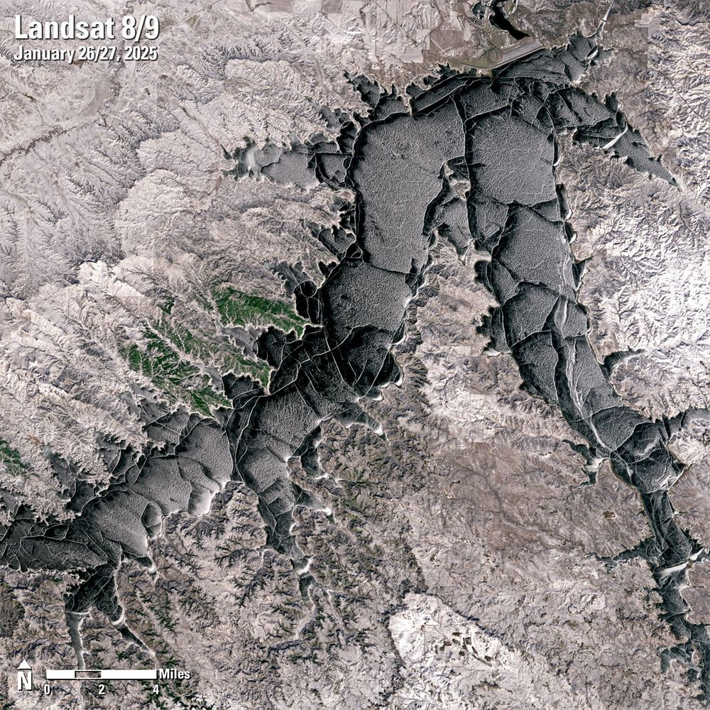
During the winter months, Fort Peck Lake in Montana freezes over, transforming the area into a frosty landscape that attracts outdoor recreationists.🎣⛸️ This season, the reservoir was declared fully covered with ice on January 19, 2025. Learn more here: ow.ly/Zjtn50V3bRj
February 21, 2025 at 2:19 AM
During the winter months, Fort Peck Lake in Montana freezes over, transforming the area into a frosty landscape that attracts outdoor recreationists.🎣⛸️ This season, the reservoir was declared fully covered with ice on January 19, 2025. Learn more here: ow.ly/Zjtn50V3bRj
A powerful storm system moved across the U.S. Southeast from Feb. 15-16, dropping up to 6 inches of rain and causing destructive flooding in parts of Tennessee and Kentucky. These false-color Landsat
images show the flooding in western Tennessee.
(source: NASA Earth)
images show the flooding in western Tennessee.
(source: NASA Earth)
February 20, 2025 at 4:19 AM
A powerful storm system moved across the U.S. Southeast from Feb. 15-16, dropping up to 6 inches of rain and causing destructive flooding in parts of Tennessee and Kentucky. These false-color Landsat
images show the flooding in western Tennessee.
(source: NASA Earth)
images show the flooding in western Tennessee.
(source: NASA Earth)
Mount Etna is Europe’s largest and most active volcano. #Landsat images acquired on February 12th and 13th highlight the recent activity of Sicily's snow-capped stratovolcano. Learn more here: ow.ly/I3sM50V0uc0
February 15, 2025 at 4:31 PM
Mount Etna is Europe’s largest and most active volcano. #Landsat images acquired on February 12th and 13th highlight the recent activity of Sicily's snow-capped stratovolcano. Learn more here: ow.ly/I3sM50V0uc0
#DidYouKnow Landsat 8 was the first Landsat mission to use lunar calibration? 🌕 Every month, the satellite pivots to point at the moon and scans the distant lunar surface multiple times to ensure that the Operational Land Imager (OLI) is detecting light consistently.
February 13, 2025 at 4:32 AM
#DidYouKnow Landsat 8 was the first Landsat mission to use lunar calibration? 🌕 Every month, the satellite pivots to point at the moon and scans the distant lunar surface multiple times to ensure that the Operational Land Imager (OLI) is detecting light consistently.
Are you ready to unwind, relax, and explore the #Earth? One of our latest videos features a full hour of mesmerizing #Landsat images that take you on a peaceful journey of the world. Watch here: ow.ly/HftI50UYbnp
February 13, 2025 at 4:13 AM
Are you ready to unwind, relax, and explore the #Earth? One of our latest videos features a full hour of mesmerizing #Landsat images that take you on a peaceful journey of the world. Watch here: ow.ly/HftI50UYbnp
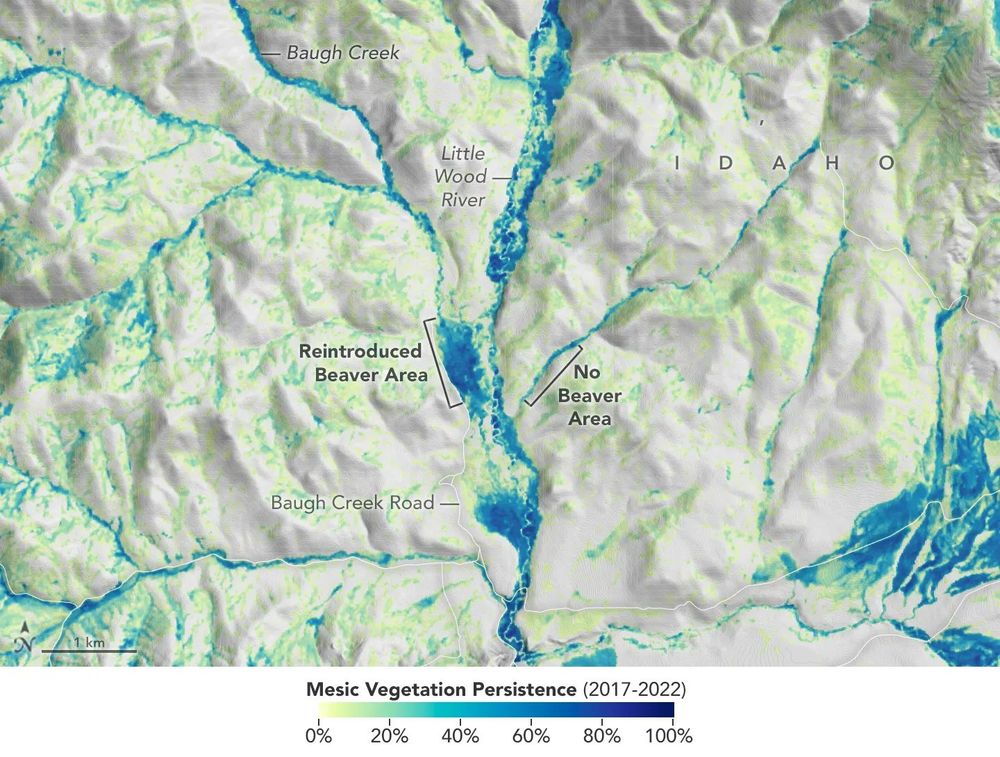
🦫 Researchers used #Landsat data to identify streams where beavers can be reintroduced to help improve an ecosystem. The vegetation in this image indicates where streams or creeks are flowing and reveals the benefits of beaver activity.
spinoff.nasa.gov/Beavers_Buil...
spinoff.nasa.gov/Beavers_Buil...
February 13, 2025 at 4:11 AM
🦫 Researchers used #Landsat data to identify streams where beavers can be reintroduced to help improve an ecosystem. The vegetation in this image indicates where streams or creeks are flowing and reveals the benefits of beaver activity.
spinoff.nasa.gov/Beavers_Buil...
spinoff.nasa.gov/Beavers_Buil...
Want to visualize Landsat images in EarthExplorer from a fresh perspective? EarthExplorer now offers a suite of Browse Overlay Options, allowing you to display different band combinations and spectral indices. Learn more by checking out EarthExplorer Help: ow.ly/vNFe50TvGvL
February 11, 2025 at 4:54 PM
Want to visualize Landsat images in EarthExplorer from a fresh perspective? EarthExplorer now offers a suite of Browse Overlay Options, allowing you to display different band combinations and spectral indices. Learn more by checking out EarthExplorer Help: ow.ly/vNFe50TvGvL
🍊 Fresh Imagery (Feb 10, 2025)
Emi Koussi in Chad was observed today by Landsat 8. It's the largest volcano in the Sahara.
earthexplorer.usgs.gov/scene/metada...
Emi Koussi in Chad was observed today by Landsat 8. It's the largest volcano in the Sahara.
earthexplorer.usgs.gov/scene/metada...

February 11, 2025 at 5:36 AM
🍊 Fresh Imagery (Feb 10, 2025)
Emi Koussi in Chad was observed today by Landsat 8. It's the largest volcano in the Sahara.
earthexplorer.usgs.gov/scene/metada...
Emi Koussi in Chad was observed today by Landsat 8. It's the largest volcano in the Sahara.
earthexplorer.usgs.gov/scene/metada...
The Chesapeake Bay region has experienced substantial population growth over the last several decades. #AnnualNLCD leverages nearly four decades of #Landsat data to help understand the extent, patterns, and impacts of land cover change. Learn more here: ow.ly/eMJE50UW0ig
February 10, 2025 at 8:19 PM
The Chesapeake Bay region has experienced substantial population growth over the last several decades. #AnnualNLCD leverages nearly four decades of #Landsat data to help understand the extent, patterns, and impacts of land cover change. Learn more here: ow.ly/eMJE50UW0ig