


Lothar Schüller
@lotharschueller.bsky.social
SAF Network Manager at EUMETSAT
On 1 July, the 108ᵗʰ EUMETSAT Council approved the updated SAF Strategy — a major step to keep the SAF Network agile, innovative, and user-focused. It introduces inter alia an Innovation Layer, supports EU activities, and enables open-source licensing for SAF software. @eumetsat.int


July 4, 2025 at 2:35 PM
On 1 July, the 108ᵗʰ EUMETSAT Council approved the updated SAF Strategy — a major step to keep the SAF Network agile, innovative, and user-focused. It introduces inter alia an Innovation Layer, supports EU activities, and enables open-source licensing for SAF software. @eumetsat.int
Reposted by Lothar Schüller

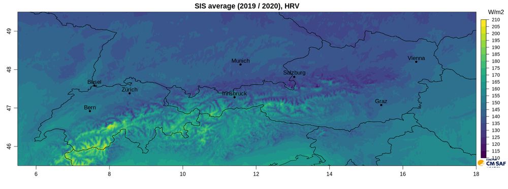
🌞 Just released: HANNA – high-res solar radiation data for Europe!
15-min resolution, \~1 km grid, derived from Meteosat rapid scans with terrain-aware processing.
Perfect for PV modeling, now available for 2019–2020
via CM SAF.
More: [email protected]
15-min resolution, \~1 km grid, derived from Meteosat rapid scans with terrain-aware processing.
Perfect for PV modeling, now available for 2019–2020
via CM SAF.
More: [email protected]
May 14, 2025 at 3:00 PM
🌞 Just released: HANNA – high-res solar radiation data for Europe!
15-min resolution, \~1 km grid, derived from Meteosat rapid scans with terrain-aware processing.
Perfect for PV modeling, now available for 2019–2020
via CM SAF.
More: [email protected]
15-min resolution, \~1 km grid, derived from Meteosat rapid scans with terrain-aware processing.
Perfect for PV modeling, now available for 2019–2020
via CM SAF.
More: [email protected]
Reposted by Lothar Schüller
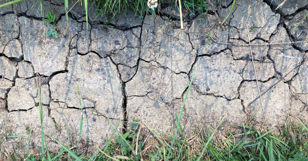
🇨🇭 Switzerland has launched a new national drought early warning system!
It combines satellite and model data − including surface temperature data from EUMETSAT’s CM SAF − to assess vegetation stress.
A great example of climate data in action:
www.trockenheit.admin.ch/de/regionen/...
It combines satellite and model data − including surface temperature data from EUMETSAT’s CM SAF − to assess vegetation stress.
A great example of climate data in action:
www.trockenheit.admin.ch/de/regionen/...
westliches Mittelland - Nationale Trockenheitsplattform
Übersicht über die regionale Trockenheitssituation. Auf dieser Seite werden die Werte des Trockenheitsindexes sowie alle Faktoren, die zur Trockenheit in der jeweiligen Region beitragen, angezeigt (Ni...
www.trockenheit.admin.ch
May 15, 2025 at 6:49 AM
🇨🇭 Switzerland has launched a new national drought early warning system!
It combines satellite and model data − including surface temperature data from EUMETSAT’s CM SAF − to assess vegetation stress.
A great example of climate data in action:
www.trockenheit.admin.ch/de/regionen/...
It combines satellite and model data − including surface temperature data from EUMETSAT’s CM SAF − to assess vegetation stress.
A great example of climate data in action:
www.trockenheit.admin.ch/de/regionen/...
Reposted by Lothar Schüller

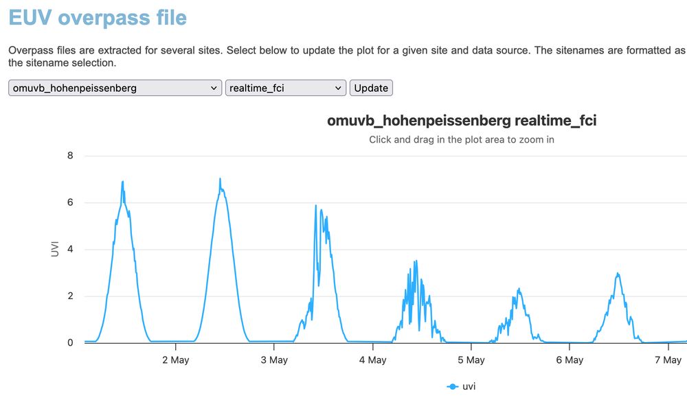
Did you know that cloud corrected European #UVI and #Erythemal daily dose from EUMETSAT's MSG #SEVIRI (2004-2024) and MTG #FCI (2025->) data are available. 15 min time resolution. Data, maps and #overpasses available. Data: acsaf.org/products/euv... , images and overpasses acsaf.org/euv_validati...
May 13, 2025 at 8:06 AM
Did you know that cloud corrected European #UVI and #Erythemal daily dose from EUMETSAT's MSG #SEVIRI (2004-2024) and MTG #FCI (2025->) data are available. 15 min time resolution. Data, maps and #overpasses available. Data: acsaf.org/products/euv... , images and overpasses acsaf.org/euv_validati...
Reposted by Lothar Schüller
Did you know that cloud corrected European #UVI and #Erythemal daily dose from EUMETSAT's MSG #SEVIRI (2004-2024) and MTG #FCI (2025->) data are available. 15 min time resolution. Data, maps and #overpasses available. Images and overpasses acsaf.org/euv_validation/index.php
May 13, 2025 at 8:14 AM
Did you know that cloud corrected European #UVI and #Erythemal daily dose from EUMETSAT's MSG #SEVIRI (2004-2024) and MTG #FCI (2025->) data are available. 15 min time resolution. Data, maps and #overpasses available. Images and overpasses acsaf.org/euv_validation/index.php
Reposted by Lothar Schüller
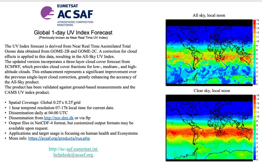
The Global 1-day UV Index Forecast is released today. This version have a three-layer cloud cover forecast from ECMWF, which provides cloud cover fractions for low-, medium-, and high-altitude clouds. Clear improvement over the previous single-layer cloud correction. acsaf.org/products/nuv...
May 13, 2025 at 12:59 PM
The Global 1-day UV Index Forecast is released today. This version have a three-layer cloud cover forecast from ECMWF, which provides cloud cover fractions for low-, medium-, and high-altitude clouds. Clear improvement over the previous single-layer cloud correction. acsaf.org/products/nuv...
Reposted by Lothar Schüller
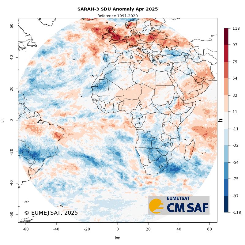
Looks like space agrees! 🌍
Our satellite-based data also show a strong sunshine duration anomaly over the UK in April 2025.
Sneak peek here 👉 bsky.app/profile/cm-s...
Our satellite-based data also show a strong sunshine duration anomaly over the UK in April 2025.
Sneak peek here 👉 bsky.app/profile/cm-s...
🌞 Sneak peek: CM SAF's upcoming demonstrational anomaly service!
Shown: SDU anomaly for April 2025 — strong positive values over the UK & Central Europe.
Got thoughts or feedback? We'd love to hear from you!
#Sunshine #ClimateData #SatelliteObservations
Shown: SDU anomaly for April 2025 — strong positive values over the UK & Central Europe.
Got thoughts or feedback? We'd love to hear from you!
#Sunshine #ClimateData #SatelliteObservations
May 5, 2025 at 11:47 AM
Looks like space agrees! 🌍
Our satellite-based data also show a strong sunshine duration anomaly over the UK in April 2025.
Sneak peek here 👉 bsky.app/profile/cm-s...
Our satellite-based data also show a strong sunshine duration anomaly over the UK in April 2025.
Sneak peek here 👉 bsky.app/profile/cm-s...
Reposted by Lothar Schüller
Sea ice data on @polarportal.bsky.social is from European @osi-saf.eumetsat.int group, sea ice thickness + Greenland surface mass balance is from @dmidk.bsky.social's operational models + #GRACE satellite data is from our partners @dtucryo.bsky.social as part of @esaclimate.bsky.social ❄️🥼⚒️🧪⛏️🌊
Good morning! Quick reminder that you can see the current state of the #Arctic #SeaIce on @polarportal.bsky.social where you can also see how the # Greenland Ice Sheet mass budget from GRACE and the daily surface mass budget from @dmidk.bsky.social Some big improvements + new data coming soon too


May 7, 2025 at 6:05 AM
Sea ice data on @polarportal.bsky.social is from European @osi-saf.eumetsat.int group, sea ice thickness + Greenland surface mass balance is from @dmidk.bsky.social's operational models + #GRACE satellite data is from our partners @dtucryo.bsky.social as part of @esaclimate.bsky.social ❄️🥼⚒️🧪⛏️🌊
Reposted by Lothar Schüller
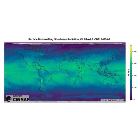
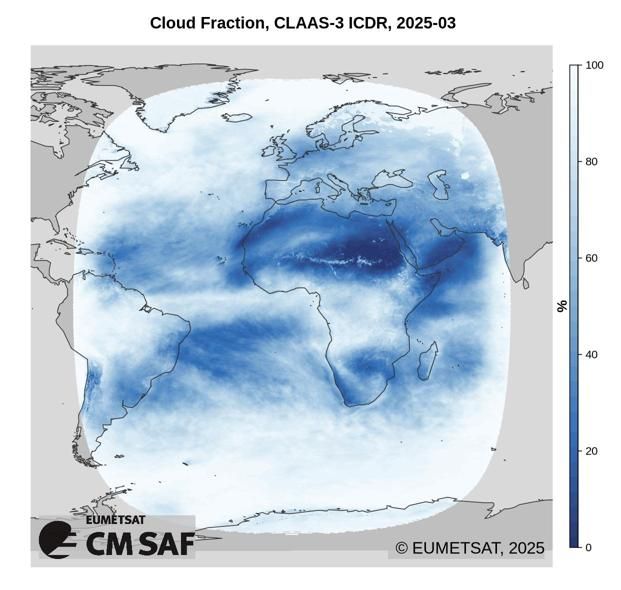
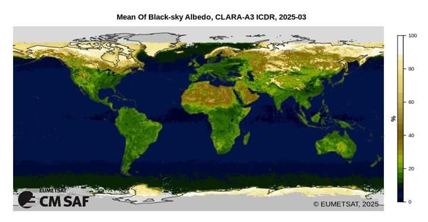
📢 CM SAF is now on Bluesky! ☁️
We provide satellite-based climate data on key parameters of the Earth’s energy and water cycle – including:
☀️ radiation (surface & TOA), sunshine duration
☁️ cloud fraction
🌧️ precipitation, water vapour
🌎 surface albedo and more.
🔗 Explore our data: cm-saf.eumetsat.int
We provide satellite-based climate data on key parameters of the Earth’s energy and water cycle – including:
☀️ radiation (surface & TOA), sunshine duration
☁️ cloud fraction
🌧️ precipitation, water vapour
🌎 surface albedo and more.
🔗 Explore our data: cm-saf.eumetsat.int
April 25, 2025 at 8:59 AM
📢 CM SAF is now on Bluesky! ☁️
We provide satellite-based climate data on key parameters of the Earth’s energy and water cycle – including:
☀️ radiation (surface & TOA), sunshine duration
☁️ cloud fraction
🌧️ precipitation, water vapour
🌎 surface albedo and more.
🔗 Explore our data: cm-saf.eumetsat.int
We provide satellite-based climate data on key parameters of the Earth’s energy and water cycle – including:
☀️ radiation (surface & TOA), sunshine duration
☁️ cloud fraction
🌧️ precipitation, water vapour
🌎 surface albedo and more.
🔗 Explore our data: cm-saf.eumetsat.int
Reposted by Lothar Schüller

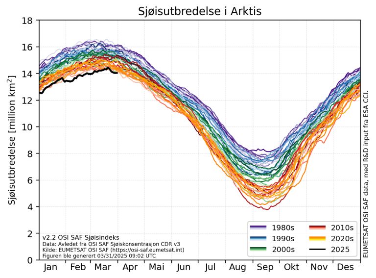
Vintersesongen er over i Arktis og sjøisen vil smelte gjennom våren og sommeren 🧊
Sjøisen sin maksimale utbredelse ble 14,43 millioner km², 1 million km² mindre enn normalt.
– Det er det laveste nivået vi har målt etter vintersesongen, sier klimaforsker Thomas Lavergne.
👉 shorturl.at/PAX0a
Sjøisen sin maksimale utbredelse ble 14,43 millioner km², 1 million km² mindre enn normalt.
– Det er det laveste nivået vi har målt etter vintersesongen, sier klimaforsker Thomas Lavergne.
👉 shorturl.at/PAX0a
April 2, 2025 at 1:25 PM
Vintersesongen er over i Arktis og sjøisen vil smelte gjennom våren og sommeren 🧊
Sjøisen sin maksimale utbredelse ble 14,43 millioner km², 1 million km² mindre enn normalt.
– Det er det laveste nivået vi har målt etter vintersesongen, sier klimaforsker Thomas Lavergne.
👉 shorturl.at/PAX0a
Sjøisen sin maksimale utbredelse ble 14,43 millioner km², 1 million km² mindre enn normalt.
– Det er det laveste nivået vi har målt etter vintersesongen, sier klimaforsker Thomas Lavergne.
👉 shorturl.at/PAX0a
Reposted by Lothar Schüller
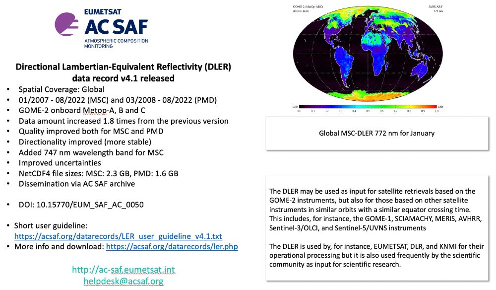
Directional #Lambertian-Equivalent #Reflectivity (DLER) version 4.1 is finally released. It has been available as demonstrational product a while, but now we can announce the official release. Added wl, improved errors, directionality and quality. Download and have a try! acsaf.org/datarecords/...
March 14, 2025 at 1:48 PM
Directional #Lambertian-Equivalent #Reflectivity (DLER) version 4.1 is finally released. It has been available as demonstrational product a while, but now we can announce the official release. Added wl, improved errors, directionality and quality. Download and have a try! acsaf.org/datarecords/...
Reposted by Lothar Schüller
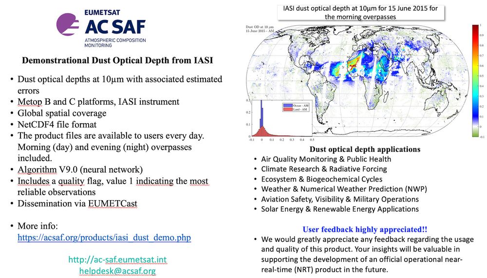
Demonstrational IASI dust optical depth available via EUMETCast. More info and instructions: acsaf.org/products/ias...
February 5, 2025 at 7:23 AM
Demonstrational IASI dust optical depth available via EUMETCast. More info and instructions: acsaf.org/products/ias...
Reposted by Lothar Schüller

In the past months, we've been updating our knowledge about our users, and we got some new answers ! Thanks to every one of you that took the time to communicate with us.
On our website, we tried to summarize what we know about our users. Learn more there :
osi-saf.eumetsat.int/community/st...
On our website, we tried to summarize what we know about our users. Learn more there :
osi-saf.eumetsat.int/community/st...
Who is using OSI SAF products? | OSI SAF
osi-saf.eumetsat.int
February 21, 2025 at 4:40 PM
In the past months, we've been updating our knowledge about our users, and we got some new answers ! Thanks to every one of you that took the time to communicate with us.
On our website, we tried to summarize what we know about our users. Learn more there :
osi-saf.eumetsat.int/community/st...
On our website, we tried to summarize what we know about our users. Learn more there :
osi-saf.eumetsat.int/community/st...
Reposted by Lothar Schüller
On last tuesday (04/03/2025), we released a new version of our Sea Ice Emissivity (OSI-404-b) and of our Global Low Resolution Sea Ice Drift (OSI-405-d) products.
For more details about the new version, consult the product description page :
osi-saf.eumetsat.int/products/sea...
For more details about the new version, consult the product description page :
osi-saf.eumetsat.int/products/sea...


March 7, 2025 at 4:01 PM
On last tuesday (04/03/2025), we released a new version of our Sea Ice Emissivity (OSI-404-b) and of our Global Low Resolution Sea Ice Drift (OSI-405-d) products.
For more details about the new version, consult the product description page :
osi-saf.eumetsat.int/products/sea...
For more details about the new version, consult the product description page :
osi-saf.eumetsat.int/products/sea...
Reposted by Lothar Schüller
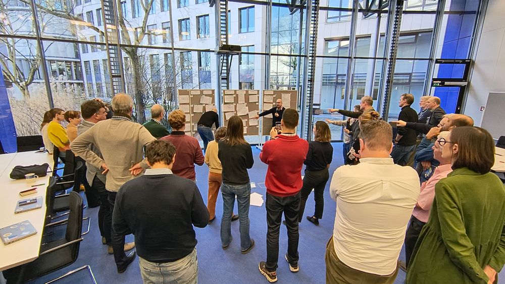
@eumetsat.bsky.social
SAF Network meeting to plan the next phase for 2027-2032. New products, new services.
SAF Network meeting to plan the next phase for 2027-2032. New products, new services.
February 19, 2025 at 1:53 PM
@eumetsat.bsky.social
SAF Network meeting to plan the next phase for 2027-2032. New products, new services.
SAF Network meeting to plan the next phase for 2027-2032. New products, new services.
Reposted by Lothar Schüller

The #StateOfClimate report reveals record-breaking global temps, with 2024 being the warmest year on record. 🌡️
Sea-level rise & ocean warming continue to accelerate.
(Sea-ice data come from @eumetsat.int's OSI SAF).
The need for stronger #ClimateAction has never been more urgent. ⬇️
Sea-level rise & ocean warming continue to accelerate.
(Sea-ice data come from @eumetsat.int's OSI SAF).
The need for stronger #ClimateAction has never been more urgent. ⬇️
🔴The #StateOfClimate report, released today, reveals key climate change indicators again reached record levels in 2024.
Check out the full report: wmo.int/publication-...
Check out the full report: wmo.int/publication-...
March 19, 2025 at 9:57 AM
The #StateOfClimate report reveals record-breaking global temps, with 2024 being the warmest year on record. 🌡️
Sea-level rise & ocean warming continue to accelerate.
(Sea-ice data come from @eumetsat.int's OSI SAF).
The need for stronger #ClimateAction has never been more urgent. ⬇️
Sea-level rise & ocean warming continue to accelerate.
(Sea-ice data come from @eumetsat.int's OSI SAF).
The need for stronger #ClimateAction has never been more urgent. ⬇️