


♿ transit-oriented traditionalist ⛈️
@mesynsupreme.bsky.social
Eisenhower conservative, minister, ⛈ tracker. 🎮💻🚲🌱. 🇺🇸🇪🇹🇮🇱🇺🇦. ASD/ID/PTSD/BP. disability dignity + SA survivor activist.
🌪 Tornado Emergency 🌪
SE Williamson & S Sabine Counties, Illinois - large confirmed tornado currently approaching the vicinity of Carrier Mills & Harrisburg.
Monster hail & heavy rains from Broughton to Eldorado & vicinity
it's shelter time now!
⛈🌀🌥
#ilwx #wxtwitter #wxbluesky #blueskywx
SE Williamson & S Sabine Counties, Illinois - large confirmed tornado currently approaching the vicinity of Carrier Mills & Harrisburg.
Monster hail & heavy rains from Broughton to Eldorado & vicinity
it's shelter time now!
⛈🌀🌥
#ilwx #wxtwitter #wxbluesky #blueskywx

May 16, 2025 at 11:40 PM
🌪 Tornado Emergency 🌪
SE Williamson & S Sabine Counties, Illinois - large confirmed tornado currently approaching the vicinity of Carrier Mills & Harrisburg.
Monster hail & heavy rains from Broughton to Eldorado & vicinity
it's shelter time now!
⛈🌀🌥
#ilwx #wxtwitter #wxbluesky #blueskywx
SE Williamson & S Sabine Counties, Illinois - large confirmed tornado currently approaching the vicinity of Carrier Mills & Harrisburg.
Monster hail & heavy rains from Broughton to Eldorado & vicinity
it's shelter time now!
⛈🌀🌥
#ilwx #wxtwitter #wxbluesky #blueskywx
These western Ohio River Valley storms are still fierce & running on rocket fuel, after a tornado straight up struck the core of St Louis.
- storm w/ likely tornado approaching Carbondale, IL & vicinity...
#wxtwitter #kywx #mowx #ilwx #arwx #inwx #ohwx #weatherupdate #tornadowarning
⛈🌀🌥 - 🧵
- storm w/ likely tornado approaching Carbondale, IL & vicinity...
#wxtwitter #kywx #mowx #ilwx #arwx #inwx #ohwx #weatherupdate #tornadowarning
⛈🌀🌥 - 🧵

May 16, 2025 at 11:00 PM
These western Ohio River Valley storms are still fierce & running on rocket fuel, after a tornado straight up struck the core of St Louis.
- storm w/ likely tornado approaching Carbondale, IL & vicinity...
#wxtwitter #kywx #mowx #ilwx #arwx #inwx #ohwx #weatherupdate #tornadowarning
⛈🌀🌥 - 🧵
- storm w/ likely tornado approaching Carbondale, IL & vicinity...
#wxtwitter #kywx #mowx #ilwx #arwx #inwx #ohwx #weatherupdate #tornadowarning
⛈🌀🌥 - 🧵
Basically all of SW Michigan from just north of Grand Rapids, down to the MI-IN border around South Bend, needs to brace for the possibility of up to hurricane force (75 mph) wind gusts.
#miwx #wxtwitter #weatherupdate #severeweather #wxbluesky #blueskywx
⛈🌀🌥
#miwx #wxtwitter #weatherupdate #severeweather #wxbluesky #blueskywx
⛈🌀🌥

May 16, 2025 at 2:05 AM
Basically all of SW Michigan from just north of Grand Rapids, down to the MI-IN border around South Bend, needs to brace for the possibility of up to hurricane force (75 mph) wind gusts.
#miwx #wxtwitter #weatherupdate #severeweather #wxbluesky #blueskywx
⛈🌀🌥
#miwx #wxtwitter #weatherupdate #severeweather #wxbluesky #blueskywx
⛈🌀🌥
This storm closing in on Sheboygan, Wisconsin likely contains a tornado - completely rain-wrapped, so it'd not be visible before it hits a given location.
Shelter now in this whole greater area.
⛈🌀🌥
#wiwx #wxtwitter #tornadowarning #wisconsin #weatherupdate #weather #wxbluesky #blueskywx
Shelter now in this whole greater area.
⛈🌀🌥
#wiwx #wxtwitter #tornadowarning #wisconsin #weatherupdate #weather #wxbluesky #blueskywx

May 16, 2025 at 12:01 AM
This storm closing in on Sheboygan, Wisconsin likely contains a tornado - completely rain-wrapped, so it'd not be visible before it hits a given location.
Shelter now in this whole greater area.
⛈🌀🌥
#wiwx #wxtwitter #tornadowarning #wisconsin #weatherupdate #weather #wxbluesky #blueskywx
Shelter now in this whole greater area.
⛈🌀🌥
#wiwx #wxtwitter #tornadowarning #wisconsin #weatherupdate #weather #wxbluesky #blueskywx
it's also time for the entirety of the greater Wausau, WI area to prepare for a likely tornadic storm to impact.
⛈🌀🌥
#wiwx #wxtwitter #weather #tornadowarning #weatherupdate #wxbluesky #blueskywx
⛈🌀🌥
#wiwx #wxtwitter #weather #tornadowarning #weatherupdate #wxbluesky #blueskywx

May 15, 2025 at 10:24 PM
it's also time for the entirety of the greater Wausau, WI area to prepare for a likely tornadic storm to impact.
⛈🌀🌥
#wiwx #wxtwitter #weather #tornadowarning #weatherupdate #wxbluesky #blueskywx
⛈🌀🌥
#wiwx #wxtwitter #weather #tornadowarning #weatherupdate #wxbluesky #blueskywx
Duluth, MN - brace for a storm with a likely tornado, approaching FAST (60 mph!) from the south, y'all.
the Oshkosh area (& points SW like Green Lake & Markesan) needs to also brace for similar
as well as the I-39 corridor from Coloma to Stevens Point, WI
⛈🌀🌥
#wxtwitter #mnwx #wiwx #wxbluesky
the Oshkosh area (& points SW like Green Lake & Markesan) needs to also brace for similar
as well as the I-39 corridor from Coloma to Stevens Point, WI
⛈🌀🌥
#wxtwitter #mnwx #wiwx #wxbluesky


May 15, 2025 at 10:11 PM
Duluth, MN - brace for a storm with a likely tornado, approaching FAST (60 mph!) from the south, y'all.
the Oshkosh area (& points SW like Green Lake & Markesan) needs to also brace for similar
as well as the I-39 corridor from Coloma to Stevens Point, WI
⛈🌀🌥
#wxtwitter #mnwx #wiwx #wxbluesky
the Oshkosh area (& points SW like Green Lake & Markesan) needs to also brace for similar
as well as the I-39 corridor from Coloma to Stevens Point, WI
⛈🌀🌥
#wxtwitter #mnwx #wiwx #wxbluesky
#SevereWeather outbreak in store today, y'all, for the upper Mississippi & upper Ohio River Valleys - including MN, WI, IL, extreme eastern MO, KY, WV, OH, PA, IN, western MD, MI, & even far southern ON. 🧵
#wxbluesky #blueskywx #wxtwitter #mnwx #wiwx #wiwx #ilwx #miwx #onwx #pawx #ohwx #kywx #inwx
#wxbluesky #blueskywx #wxtwitter #mnwx #wiwx #wiwx #ilwx #miwx #onwx #pawx #ohwx #kywx #inwx

May 15, 2025 at 11:01 AM
#SevereWeather outbreak in store today, y'all, for the upper Mississippi & upper Ohio River Valleys - including MN, WI, IL, extreme eastern MO, KY, WV, OH, PA, IN, western MD, MI, & even far southern ON. 🧵
#wxbluesky #blueskywx #wxtwitter #mnwx #wiwx #wiwx #ilwx #miwx #onwx #pawx #ohwx #kywx #inwx
#wxbluesky #blueskywx #wxtwitter #mnwx #wiwx #wiwx #ilwx #miwx #onwx #pawx #ohwx #kywx #inwx
every1's a G 'til the storm goes "dino head" 💀
but seriously: today features widespread storms in OK & TX, many severe, with all modes - including 🌪s - possible. 🌪 potential's centered from Austin-Houston.
#okwx #lawx #mswx #txwx #arwx #cowx #wxtwitter #weatherupdate #weather #wxbluesky #blueskywx
but seriously: today features widespread storms in OK & TX, many severe, with all modes - including 🌪s - possible. 🌪 potential's centered from Austin-Houston.
#okwx #lawx #mswx #txwx #arwx #cowx #wxtwitter #weatherupdate #weather #wxbluesky #blueskywx
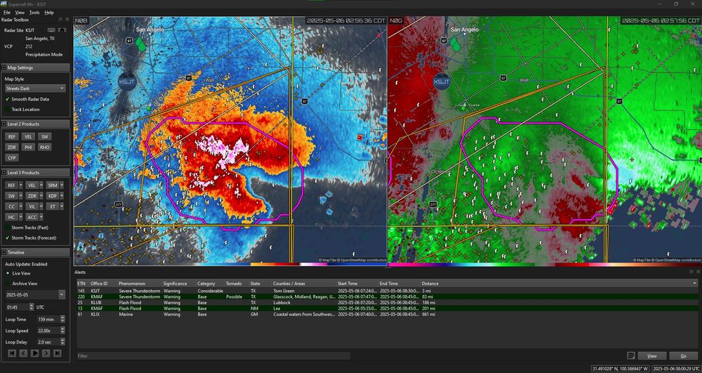
May 6, 2025 at 8:16 AM
every1's a G 'til the storm goes "dino head" 💀
but seriously: today features widespread storms in OK & TX, many severe, with all modes - including 🌪s - possible. 🌪 potential's centered from Austin-Houston.
#okwx #lawx #mswx #txwx #arwx #cowx #wxtwitter #weatherupdate #weather #wxbluesky #blueskywx
but seriously: today features widespread storms in OK & TX, many severe, with all modes - including 🌪s - possible. 🌪 potential's centered from Austin-Houston.
#okwx #lawx #mswx #txwx #arwx #cowx #wxtwitter #weatherupdate #weather #wxbluesky #blueskywx
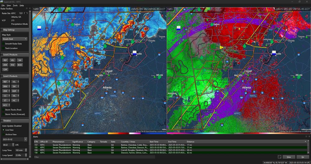
Ain't much hail in these storms approaching metro Atlanta, but they are gully-washers & a very windy affair - prepare for damaging winds up to & exceeding 60mph, watch for rising waters, & remember: turn around, don't drown!
#gawx #wxtwitter #severeweather #WeatherUpdate #wxbluesky #blueskywx
⛈🌀🌥
#gawx #wxtwitter #severeweather #WeatherUpdate #wxbluesky #blueskywx
⛈🌀🌥
May 3, 2025 at 1:09 AM
Ain't much hail in these storms approaching metro Atlanta, but they are gully-washers & a very windy affair - prepare for damaging winds up to & exceeding 60mph, watch for rising waters, & remember: turn around, don't drown!
#gawx #wxtwitter #severeweather #WeatherUpdate #wxbluesky #blueskywx
⛈🌀🌥
#gawx #wxtwitter #severeweather #WeatherUpdate #wxbluesky #blueskywx
⛈🌀🌥
Confirmed tornado in southern Eau Claire county, moving NE crossing WI State 93 & Willow. This tornado is *compeltely rain-wrapped* so it will NOT be easily visible from a distance. Osseo, Augusta, Fall Creek, & vicinity is being bore down on.
#wiwx #wxbluesky #blueskywx #wxtwitter #tornadowarning
#wiwx #wxbluesky #blueskywx #wxtwitter #tornadowarning

April 29, 2025 at 12:48 AM
Confirmed tornado in southern Eau Claire county, moving NE crossing WI State 93 & Willow. This tornado is *compeltely rain-wrapped* so it will NOT be easily visible from a distance. Osseo, Augusta, Fall Creek, & vicinity is being bore down on.
#wiwx #wxbluesky #blueskywx #wxtwitter #tornadowarning
#wiwx #wxbluesky #blueskywx #wxtwitter #tornadowarning
All of NE Wisconsin N of Green Bay is about to get slammed by this cluster of severe storms curently just E of the US 45 corridor. These storms have all modes of severe weather in them and can produce surprise tornadoes at any moment.
#wiwx #wxbluesky #blueskywx #wxtwitter
#wiwx #wxbluesky #blueskywx #wxtwitter

April 29, 2025 at 12:33 AM
All of NE Wisconsin N of Green Bay is about to get slammed by this cluster of severe storms curently just E of the US 45 corridor. These storms have all modes of severe weather in them and can produce surprise tornadoes at any moment.
#wiwx #wxbluesky #blueskywx #wxtwitter
#wiwx #wxbluesky #blueskywx #wxtwitter
for some strong to severe storms, with - again - all modes possible. Tornadoes have been spinning up in this squall line with little warning & are completely rain-wrapped, meaning you will not see them from a distance. Hunker down. Storm direction: SW-NE.

April 28, 2025 at 11:43 PM
for some strong to severe storms, with - again - all modes possible. Tornadoes have been spinning up in this squall line with little warning & are completely rain-wrapped, meaning you will not see them from a distance. Hunker down. Storm direction: SW-NE.
Severe Weather Update 🧵
=====
* Minnesota/Iowa Storms: Just crossed the I-35 Corridor in MN & are approaching the same in IA. Anyone in SE Minnesota + North Central (& eventually NE) Iowa needs to prepare...
#wxtwitter #mnwx #iawx #sdwx #newx #kswx #mowx #arwx #okwx #txwx #blueskywx #wxbluesky
=====
* Minnesota/Iowa Storms: Just crossed the I-35 Corridor in MN & are approaching the same in IA. Anyone in SE Minnesota + North Central (& eventually NE) Iowa needs to prepare...
#wxtwitter #mnwx #iawx #sdwx #newx #kswx #mowx #arwx #okwx #txwx #blueskywx #wxbluesky


April 28, 2025 at 11:43 PM
Severe Weather Update 🧵
=====
* Minnesota/Iowa Storms: Just crossed the I-35 Corridor in MN & are approaching the same in IA. Anyone in SE Minnesota + North Central (& eventually NE) Iowa needs to prepare...
#wxtwitter #mnwx #iawx #sdwx #newx #kswx #mowx #arwx #okwx #txwx #blueskywx #wxbluesky
=====
* Minnesota/Iowa Storms: Just crossed the I-35 Corridor in MN & are approaching the same in IA. Anyone in SE Minnesota + North Central (& eventually NE) Iowa needs to prepare...
#wxtwitter #mnwx #iawx #sdwx #newx #kswx #mowx #arwx #okwx #txwx #blueskywx #wxbluesky
The I-35 Corridor from teh south end of the Minneapolis/St Paul metro down to Albert Lea + the state-line area of MN/IA from MAson City west needs to prepare for a potent storm cluster containing likely rain-wrapped tornadoes...
#mnwx #iawx #wxtwitter #wxbluesky #blueskywx
#mnwx #iawx #wxtwitter #wxbluesky #blueskywx

April 28, 2025 at 10:40 PM
The I-35 Corridor from teh south end of the Minneapolis/St Paul metro down to Albert Lea + the state-line area of MN/IA from MAson City west needs to prepare for a potent storm cluster containing likely rain-wrapped tornadoes...
#mnwx #iawx #wxtwitter #wxbluesky #blueskywx
#mnwx #iawx #wxtwitter #wxbluesky #blueskywx
Morning non-severe storms in the Upper Midwest will give way to severe storms late afternoon & evening - w/ all modes, including tornadoes, possible for the UM + mid-MIMAL + eastern Central Plains.
I'll be covering the outbreak, y'all.
#wxbluesky #blueskywx #wxtwitter #weather
I'll be covering the outbreak, y'all.
#wxbluesky #blueskywx #wxtwitter #weather

April 28, 2025 at 12:55 PM
Morning non-severe storms in the Upper Midwest will give way to severe storms late afternoon & evening - w/ all modes, including tornadoes, possible for the UM + mid-MIMAL + eastern Central Plains.
I'll be covering the outbreak, y'all.
#wxbluesky #blueskywx #wxtwitter #weather
I'll be covering the outbreak, y'all.
#wxbluesky #blueskywx #wxtwitter #weather
This system in the Greater Mississippi River Valley packs a punch, y'all. Anyone in this region (especially in the Tornado Watches) should basically assume any approaching storm is tornadic... because there's a good chance it is. I'm seeing rotation in like, 80% of cells I look at. (cont.)


April 2, 2025 at 11:07 PM
This system in the Greater Mississippi River Valley packs a punch, y'all. Anyone in this region (especially in the Tornado Watches) should basically assume any approaching storm is tornadic... because there's a good chance it is. I'm seeing rotation in like, 80% of cells I look at. (cont.)
Folks in the PNW who were hoping for something significant from y'all's first Severe T'storm Watch in (depending on location) anywhere from 5+ to 25+ years...
I'm afraid other plans prevailed. 💀🤣
Enjoy a few days of y'all's usual rain. Be mindful of flooding, though.
⛈🌀🌥
#wxbluesky #orwx #wawx
I'm afraid other plans prevailed. 💀🤣
Enjoy a few days of y'all's usual rain. Be mindful of flooding, though.
⛈🌀🌥
#wxbluesky #orwx #wawx

March 27, 2025 at 2:14 AM
Folks in the PNW who were hoping for something significant from y'all's first Severe T'storm Watch in (depending on location) anywhere from 5+ to 25+ years...
I'm afraid other plans prevailed. 💀🤣
Enjoy a few days of y'all's usual rain. Be mindful of flooding, though.
⛈🌀🌥
#wxbluesky #orwx #wawx
I'm afraid other plans prevailed. 💀🤣
Enjoy a few days of y'all's usual rain. Be mindful of flooding, though.
⛈🌀🌥
#wxbluesky #orwx #wawx
it'll never not be weird to me whenever a Severe T'storm Watch gets issued for anywhere on the West Coast lol
#wxtwitter #orwx #wawx #wxbluesky
⛈🌀🌥
#wxtwitter #orwx #wawx #wxbluesky
⛈🌀🌥

March 26, 2025 at 11:01 PM
it'll never not be weird to me whenever a Severe T'storm Watch gets issued for anywhere on the West Coast lol
#wxtwitter #orwx #wawx #wxbluesky
⛈🌀🌥
#wxtwitter #orwx #wawx #wxbluesky
⛈🌀🌥
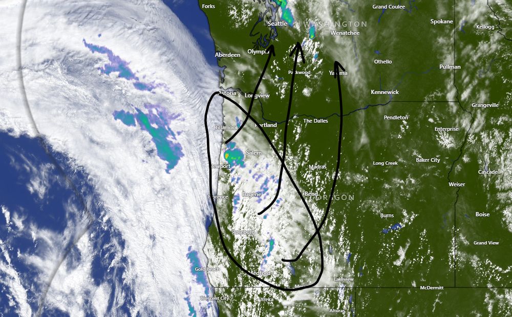
Pacific Northwest/Cascadia storms getting started in W Central & SW Oregon + a Band of light rain moving N over WA/Canada border.
Storms'll strengthen & expand coverage next several hours. Main direction for cells: a curved SW-NE-N.
All modes: hvy rain, hail, high winds, tornadoes... (cont.)
Storms'll strengthen & expand coverage next several hours. Main direction for cells: a curved SW-NE-N.
All modes: hvy rain, hail, high winds, tornadoes... (cont.)
March 26, 2025 at 10:03 PM
Pacific Northwest/Cascadia storms getting started in W Central & SW Oregon + a Band of light rain moving N over WA/Canada border.
Storms'll strengthen & expand coverage next several hours. Main direction for cells: a curved SW-NE-N.
All modes: hvy rain, hail, high winds, tornadoes... (cont.)
Storms'll strengthen & expand coverage next several hours. Main direction for cells: a curved SW-NE-N.
All modes: hvy rain, hail, high winds, tornadoes... (cont.)
Brunswick, GA & points north towards Savannah, this tornadic storm is on its way.
#gawx #wxtwitter
⛈🌀🌥
#gawx #wxtwitter
⛈🌀🌥

March 16, 2025 at 3:21 PM
Brunswick, GA & points north towards Savannah, this tornadic storm is on its way.
#gawx #wxtwitter
⛈🌀🌥
#gawx #wxtwitter
⛈🌀🌥
This storm staying persistent, y'all: large hail, high winds, & confirmed tornado headed for Oak Ridge, TN, y'all. Anyone north of Knoxville needs to be sheltering shortly.
#tnwx #wxtwitter #wxbluesky
⛈🌀🌥
#tnwx #wxtwitter #wxbluesky
⛈🌀🌥

March 16, 2025 at 12:08 AM
This storm staying persistent, y'all: large hail, high winds, & confirmed tornado headed for Oak Ridge, TN, y'all. Anyone north of Knoxville needs to be sheltering shortly.
#tnwx #wxtwitter #wxbluesky
⛈🌀🌥
#tnwx #wxtwitter #wxbluesky
⛈🌀🌥
Storm with a possible tornado - & definitely some fierce, damaging straight-line winds - rolling towards the Marion, AL area, with the I-65 Corridor S of Birmingham in its crosshairs.
#alwx #wxtwitter #wxbluesky
⛈🌀🌥
#alwx #wxtwitter #wxbluesky
⛈🌀🌥

March 15, 2025 at 11:46 PM
Storm with a possible tornado - & definitely some fierce, damaging straight-line winds - rolling towards the Marion, AL area, with the I-65 Corridor S of Birmingham in its crosshairs.
#alwx #wxtwitter #wxbluesky
⛈🌀🌥
#alwx #wxtwitter #wxbluesky
⛈🌀🌥
& for Middle TN: the TN State Route 56 corridor between McMinnville & Smithville also has a probable tornado, but at the very least is a major rolling field of straight-line winds that can still be a tornado-like danger.... (continued)
#tnwx #wxtwitter
#tnwx #wxtwitter

March 15, 2025 at 9:19 PM
& for Middle TN: the TN State Route 56 corridor between McMinnville & Smithville also has a probable tornado, but at the very least is a major rolling field of straight-line winds that can still be a tornado-like danger.... (continued)
#tnwx #wxtwitter
#tnwx #wxtwitter
from city of Birmingham, AL north along the I-22 & I-65 corridors, shelter now for this storm with strong rotation & likely tornado moving NE from the Tuscaloosa area
#wxtwitter #alwx
⛈🌀🌥
#wxtwitter #alwx
⛈🌀🌥

March 15, 2025 at 9:14 PM
from city of Birmingham, AL north along the I-22 & I-65 corridors, shelter now for this storm with strong rotation & likely tornado moving NE from the Tuscaloosa area
#wxtwitter #alwx
⛈🌀🌥
#wxtwitter #alwx
⛈🌀🌥
Antoher storm that might be warned real shortly is this one over Seminary, MS, headed for - again, like earlier storms - the Taylorsville-Laurel, MS stretch. Looking quite spinny. Keep sheltered.
⛈🌀🌥
#lawx #wxtwitter #wxbluesky
⛈🌀🌥
#lawx #wxtwitter #wxbluesky

March 15, 2025 at 9:10 PM
Antoher storm that might be warned real shortly is this one over Seminary, MS, headed for - again, like earlier storms - the Taylorsville-Laurel, MS stretch. Looking quite spinny. Keep sheltered.
⛈🌀🌥
#lawx #wxtwitter #wxbluesky
⛈🌀🌥
#lawx #wxtwitter #wxbluesky