meteologix.com
@meteologix.com
240 followers 10 following 230 posts
Weather information around the globe including satellite imagery, radar & exclusive model forecasts. Weather site: https://meteologix.com/ Company info: https://business.meteologix.com
Posts Media Videos Starter Packs
meteologix.com
It is a sleepless night at Japan's Izu Islands which are currently being affected by typhoon Halong(known as Typhoon Number 22 in Japanese). Here is the latest imagery from Himawari-9, showing Aogashima entering the eyewall:

meteologix.com/jp/satellite...

TT
meteologix.com
A look at Europe in air mass composite generated using data from Meteosat-12's FCI instrument this evening:

meteologix.com/ee/satellite...

TT
meteologix.com
Evening update on Storm Amy: Violent wind gusts, 130-150 km/h at exposed locations (and even more in the mountains!) are now spreading into Scotland. Note that many very high readings come from high elevation stations such Aonach Mor.

meteologix.com/ie/observati...

TT
meteologix.com
Storm Amy is now making its presence felt. Gusts to 122 km/h (± rounding) have been reported in Belmullet, Ireland.

meteologix.com/ie/observati...

TT
meteologix.com
A violent storm is expected in UK and Ireland beginning tomorrow. Shown is a scenario of forecast wind gusts from ECMWF through Saturday morning. Exposed locations in Scotland could see wind gusts in excess of 150 km/h:

meteologix.com/uk/model-cha...

TT
meteologix.com
Here is a look at 1 minute infrared satellite imagery from GOES-19 as the core of Hurricane Imelda moves through Bermuda. As the system is undergoing extratropical transition, significant wind gusts are possible even away from the centre.

meteologix.com/bs/satellite...

TT
meteologix.com
Hurricane Imelda is intensifying as it approaches Bermuda for either a landfall or a close approach tonight. The maximum 1 minute average wind speed is 160 km/h according to the latest NHC info. Preparations in Bermuda should be rushed to completion.

meteologix.com/bs/satellite...

TT
meteologix.com
As aurora is underway, here's a handy tool for those fighting with low level clouds - they can be easily tracked using the fog composite in Meteosat data.

Example from Estonia:
meteologix.com/ee/satellite...

TT
meteologix.com
Satellite imagery from GOES-19 is showing hurricanes Humberto and Imelda spinning in the Atlantic. While Humberto is becoming extratropical, Imelda is expected to aim towards Bermuda and arrive there at hurricane strength on Wednesday.

meteologix.com/bs/satellite...

TT
meteologix.com
Looks like another night of aurora is in store for Europe as a geomagnetic storm continues and Russel-McPherron effect is enhancing the show. The latest runs from OVATION can be pretty much read as: If it is dark and sky is clear, check the sky!

meteologix.com/ee/aurora/eu...

TT
meteologix.com
Multiple tropical impacts possible in Bermuda during the coming days. Hurricane Humberto is expected to bring tropical storm conditions beginning late Tuesday, followed by tropical storm Imelda which could be a hurricane at that time.

meteologix.com/bs/cyclone-t...

TT
meteologix.com
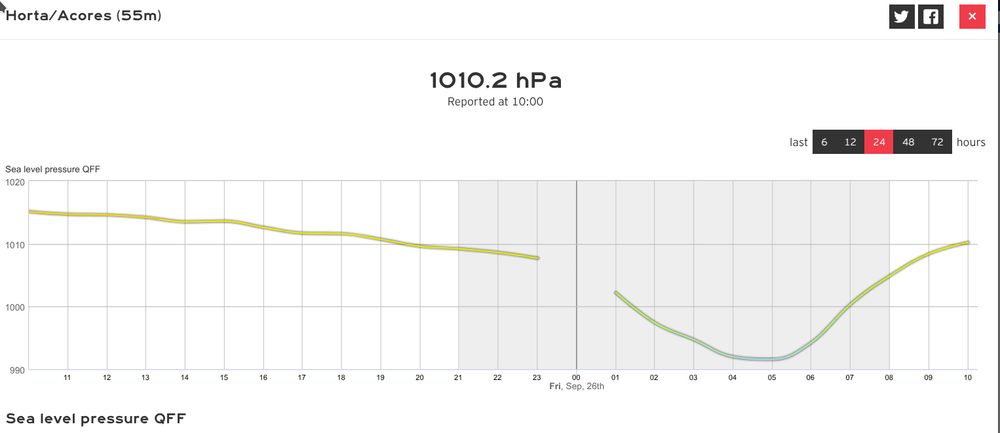
Looking back at Gabrielle in Azores, here's a graph of reported hourly wind gusts in Horta in Azores. One can also see a dip in wind speeds associated with the passage of the centre of the cyclone. Subtract 1 hour from the timestamps to get local time

meteologix.com/pt/observati...

TT
A graph from Horta in Azores, showing observed hourly peak gusts during ex-hurricane Gabrielle. Gusts exceeded 150 km/h, especially in the backside of the cyclone. A dip in wind speeds associated with the passage of the storm's centre can also be seen in the wind observations. Sea level air pressure graph for Horta in Azores during ex-hurricane Gabrielle. The lowest air pressures measured coincide with a dip of wind speeds, hinting that the storm's centre passed over the station.
meteologix.com
Hurricane Gabrielle is now visibly looking disrupted in satellite imagery and might arrive in Azores as post-tropical. However, the threats of violent winds, heavy rain and storm surge continue regardless of the type of cyclone.

meteologix.com/pt/satellite...

TT
meteologix.com
As Hurricane Gabrielle starts undergoing extratropical transition, it is expected to re-intensify and bring significant hurricane force wind gusts to Azores along with heavy rain and storm surge.

For example, an ECMWF scenario:
meteologix.com/pt/model-cha...

(Satellite image: GOES-19)

TT
meteologix.com
Note: Due to FCI Scan Encoder calibration, there are no new Meteosat-12 images available at present. New images are expected around 15 UTC. Meanwhile, here's imagery from MSG:

meteologix.com/ee/satellite...

TT
meteologix.com
Shown is our Forecast XL product for Horta in Azores, combining model scenarios for wind gusts from various models in a single graph. Impacts from Hurricane Gabrielle will begin late Thursday and will last into Friday.

meteologix.com/pt/forecast/...

TT
A comparison product of forecast wind gusts for Horta in Azores. Many models show violent gusts well over 100 km/h in association with an approaching hurricane.
meteologix.com
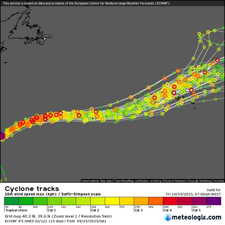
A hurricane watch is in effect for the Azores as Hurricane Gabrielle is expected to impact the islands late Thursday into Friday local time, albeit weaker than now.

ECMWF ensemble scenarios of centre path: meteologix.com/pt/cyclone-t...
Imagery from GOES-19: meteologix.com/pt/satellite...

TT
meteologix.com
Hurricane Gabrielle has rapidly intensified into a major hurricane in the Atlantic and could give some passing impacts to Bermuda today. The hurricane is expected to head towards Azores later this week but exact impacts are yet uncertain. Stay tuned.

meteologix.com/pt/satellite... (GOES-19)

TT
meteologix.com
Imagery from Himawari-9 showing the eye of Super Typhoon Ragasa (also known as Nando) crossing through the Babuyan Islands earlier today:

meteologix.com/ph/satellite...

TT
meteologix.com
Radio signals may spread farther than usual this weekend in Eastern Europe as a temperature inversion is expected in multiple countries. Here's an ECMWF forecast sounding for midnight on Sunday for a random grid point in Lithuania showing the warmer air aloft:

meteologix.com/ee/model-cha...

TT
Skew-T log P diagram based on an ECMWF model run for a point in Lithuania valid at midnight on Sunday 21st of September local time. The relevant feature is a zone of air temperature rising with height near the surface, which affects the optical features of the air and causing radio signals to bend to greater distances, trapping them near the surface instead of going straight to space.
meteologix.com
Weather is making headlines in Japan again where thunderstorm wind gusts caused damage in Ibaraki prefecture on Thursday. Heightened gusts were also visible in weather station observations:

meteologix.com/jp/observati...

TT
meteologix.com
A look at visible satellite imagery of Europe this late afternoon / early evening using data from Meteosat-12's FCI instrument.

meteologix.com/ee/satellite...

TT
meteologix.com
Europe earlier today in visible satellite imagery using data from Meteosat 12's FCI, combined with Lightning Imager groups.

meteologix.com/ee/satellite...

TT
meteologix.com
Here's a look at 12 hour maximum temperatures across Europe as of 18 UTC:

meteologix.com/ee/observati...

TT
meteologix.com
Rain is continuing to make news headlines in Japan. Tokyo and Kanagawa saw violent rainfall earlier on Thursday. For example, Haneda Airport received its highest hourly rainfall amount in its observation history. Here is an excerpt from 10 minute data:

meteologix.com/jp/observati...

TT