Ron
@mrwx4caster.bsky.social
440 followers 170 following 3.6K posts
Atmospheric-Physicist/Professional Meteorologist in applied meteorology & forecasting in the public, private and non-profit sectors. Past President of the Canadian Meteorological and Oceanographic Society. Professional member of the AMS and RMetS (UK), AGU
Posts Media Videos Starter Packs
mrwx4caster.bsky.social
...time to take a break...and a TL cleanse while watching the Jay's. 😬🤞🤞🤞 GO Jays!!!!
...one of the best Simpson episodes ever!....
(...next to the older Halloween specials, lol)
mrwx4caster.bsky.social
8pm EDT (00Z) Synoptic "Snapshot" of the weather for S. Ontario. #onwx #onstorm Mostly clear in the overnight an cool, colder in EONT and Cottage Country. Frost alert is out by ECCC.
mrwx4caster.bsky.social
8pm EDT (00Z) Synoptic "Snapshot" of the weather for N. Ontario. #onwx #onstorm Mostly clear in NONT, coldest air overnight will be found in NEONT.
mrwx4caster.bsky.social
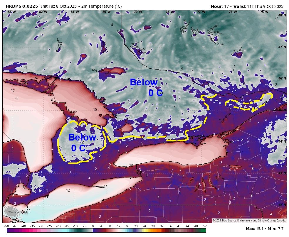
Latest on the modelling -most models have cold night in store for SONT. Conditions are perfect 4 frost to form-in frost-prone areas (away from the lakes) ECCC has issued a Frost alert 4 many southern regions of SONT. The radiational cooling peaks ~5AM - 7:30 AM EDT #onwx #onstorm
mrwx4caster.bsky.social
8am EDT (12Z) Synoptic "Snapshot" of the weather for S. Ontario. #onwx #onstorm Mainly sunny overall and cool, as cool high pressure moves in from the north. Expect daytime heating cloud,-more cloud in EONT with a very slight risk of an isolated shower. Have a great day! Go Jays!
mrwx4caster.bsky.social
8am EDT (12Z) Synoptic "Snapshot" of the weather for N. Ontario. #onwx #onstorm Mix of sun and cloud overall in the north, fair and cool will rule. Cool High pressure has settled in and sinking south.
mrwx4caster.bsky.social
How the day may play out with the latest hourly run of the HRRR model - Cloud, Radar, isobars, SFC wind vectors from now till Midnight. Instability cloud and very spotty weak showers possible in EONT. #onwx #onstorm
mrwx4caster.bsky.social
...forgot to post this last night😬...during the Jay's game, lol. "Radar estimated rainfall" (in inches) from the cold front that crossed the region. just a general overview, with a closer look at Niagara region. #onwx #onstorm If I zoom in on the GIS I see higher amounts.
mrwx4caster.bsky.social
Patchy frost a good bet tomorrow morning from SCONT/NW. SWONT thru to EONT (more extensive in EONT) traditional frost prone/higher elevation areas have the greatest risk. #onwx #onstorm (greatest risk times 5AM thru 8AM tomorrow AM)
mrwx4caster.bsky.social
8pm EDT (00Z) Synoptic "Snapshot" of the weather for S. Ontario. #onwx #onstorm
mrwx4caster.bsky.social
8pm EDT (00Z) Synoptic "Snapshot" of the weather for N. Ontario. #onwx #onstorm
mrwx4caster.bsky.social
How the latest hourly run of HRRR model see the rest of the day play out, from now till Midnight - Radar, isobars, SFC winds 4cast. cold front looks to clear later this evening as cooler air pushes thru. #onwx #onstorm
mrwx4caster.bsky.social
8am EDT (12Z) Synoptic "Snapshot" of the weather for S. Ontario. #onwx #onstorm Scattered showers a a few isolated storms continue to trek across SONT at this hour. (US radars - Only plotted)
mrwx4caster.bsky.social
8am EDT (12Z) Synoptic "Snapshot" of the weather for N. Ontario. #onwx #onstorm Colder air is beginning to move into NONT begin a secondary cold front. Still unsettled with instability showers during the day. More Rain accumulation is expected in S. sections of NEONT.
mrwx4caster.bsky.social
Current regional radar loop/trend (last 6 hrs.) till 8:00 AM EDT. Added the "rain trail" (in inches) amount which has fallen via Radar Estimated rainfall (RQPE). Also one fairly active solo storm which has lasted over 6 hrs. as it trekked across S. Ontario. #onwx #onstorm
mrwx4caster.bsky.social
0Z (8PM EDT) run of the NAM12K shows 850mb temps diving (~5k/ft) -along with a sharp (but short lived) mid-level TROF moving thru quickly -dragging colder air aloft and to the surface. Wide-spread frost ~Wed-Thurs. nights a good bet #onwx #onstorm (black line=0C at 850mb)
mrwx4caster.bsky.social
Latest Regional G. Lakes radar (last 6hrs. till 10:38 PM EDT) A general increase in coverage in scattered showers and storms in the overnight, all vectoring SW to the NE. #onwx #onstorm
mrwx4caster.bsky.social
Even tho other modeling have higher local amounts of rainfall due to embedded storms, the SREF probably guidance for at least half inch of rainfall (or~12mm) is fairly low 10-40% for most of SONT. Higher risk just south of the lower lakes. We shall see... #onwx #onstorm
mrwx4caster.bsky.social
...using the same run (see previous post) looking at Lightning potential/risk for SONT. from now till Noon Tues. darker blues (even some greens)=higher risk #onwx #onstorm
mrwx4caster.bsky.social
Latest hourly run of the HRRR model -Radar 4cast- now till noon Tues. Cold front becomes a bit more active in the overnight as it approaches SONT. Scattered showers/embedded storms in the wee hrs. of Tues. into the AM. #onwx #onstorm General motion of showers/storms SW to NE
mrwx4caster.bsky.social
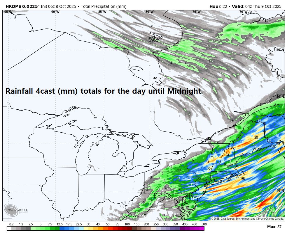
Updated total rainfall amounts (in mm) from now thru Wed. 8AM. Again, higher rainfall amounts still focused in SWONT and Niagara region, and also highly dependent on thunderstorm tracks, locally higher amounts in those tracks. #onwx #onstorm
mrwx4caster.bsky.social
8pm EDT (00Z) Synoptic "Snapshot" of the weather for S. Ontario. #onwx #onstorm Increasing clouds, and the risk of showers and scattered storms ramps up in the overnight into the morning as a cold front approaches. Much cooler air will flood in post front.
mrwx4caster.bsky.social
8pm EDT (00Z) Synoptic "Snapshot" of the weather for N. Ontario. #onwx #onstorm Post cold front showers in NWONT and a weak Low. More substantial showers, risks of storms in NEONT in the overnight.
mrwx4caster.bsky.social
8am EDT (12Z) Synoptic "Snapshot" of the weather for S. Ontario. #onwx #onstorm Another stellar day, very warm and sunny, enjoy it, things are going to become cloudy and showery and unsettled & much cooler "all good things must come to pass" -carpe diem! -Have a great day!