mundialis GmbH & Co. KG
@mundialis.mastodon.social.ap.brid.gy
3 followers 0 following 17 posts
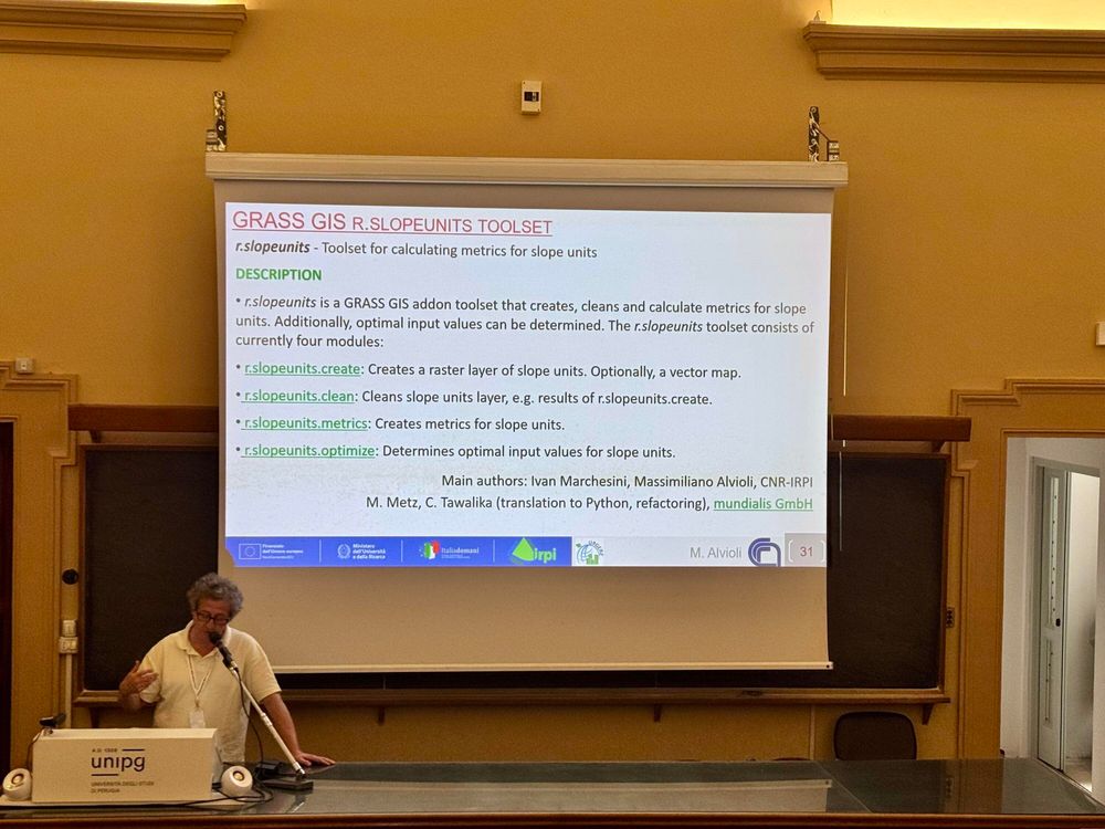
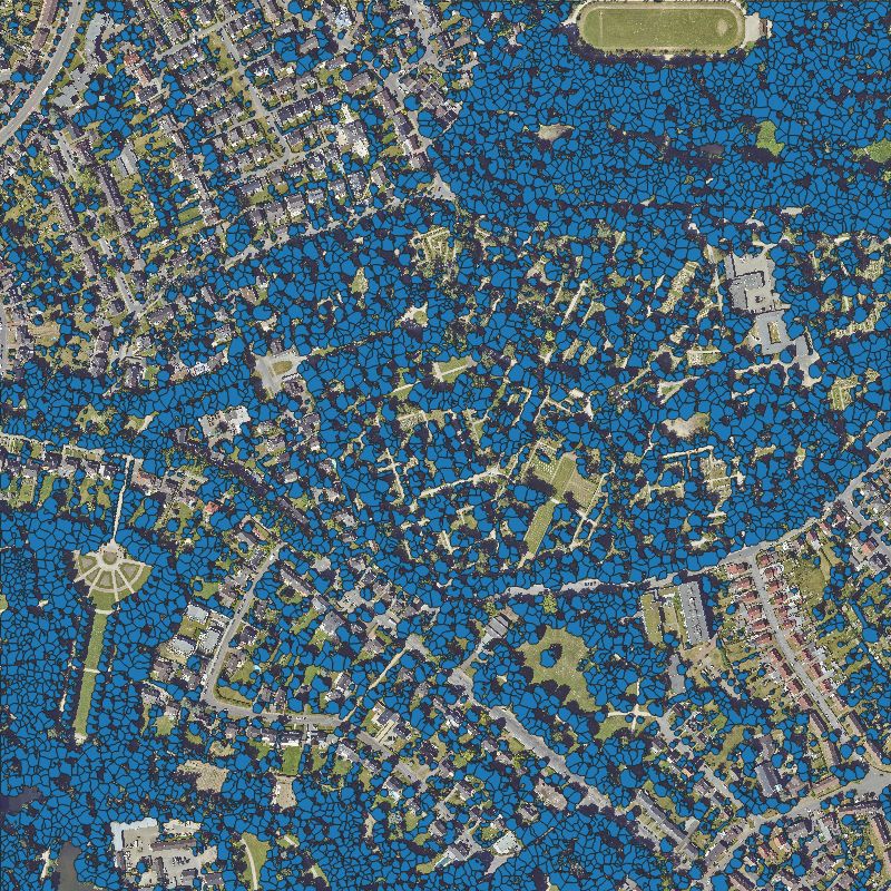
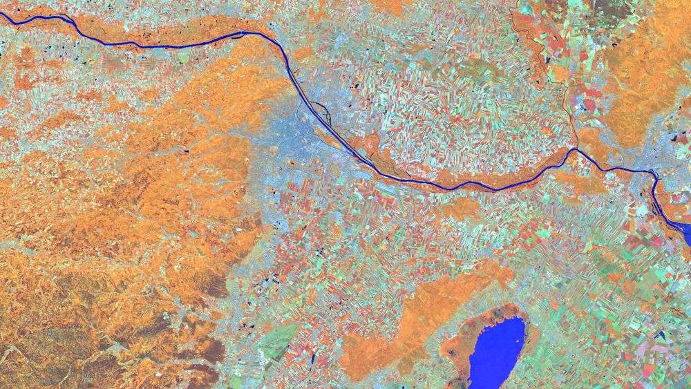
mundialis works with free geodata and free software in the remote sensing environment. We generate spatial information while developing free and open source […] [bridged from https://mastodon.social/@mundialis on the fediverse by https://fed.brid.gy/ ]
Posts Media Videos Starter Packs
mundialis.mastodon.social.ap.brid.gy
October's Satellite Image of the Month showcases the Aachen–Maastricht region, combining true color and false color composites for a unique perspective on this tri-border landscape. Learn more: https://www.mundialis.de/en/satellite-image-of-the-month-october-aachen-maastricht/
#osgeo #eo #opendata
mundialis.mastodon.social.ap.brid.gy
🎉 10 years of mundialis!
We started with a belief: data should be open, transparent & meaningful. Today, we develop open software using satellite data to tackle climate change, biodiversity loss & soil degradation.
The journey continues – with open paths & […]

[Original post on mastodon.social]
mundialis.mastodon.social.ap.brid.gy
Herzliche Einladung zu unserem kostenlosen Webseminar „Waldmonitoring mit Sentinel-2“ am 14.10.2025 von 10-10:45 Uhr!
Weitere Infos: https://www.mundialis.de/einladung-webinar-waldmonitoring-mit-sentinel-2/
mundialis.mastodon.social.ap.brid.gy
Satellite Image of the Month – #september#lofoten 🇳🇴

This #sentinel2 false-color image (bands 11-8A-4) shows Norway’s Lofoten Islands: snowy peaks in cyan, sparse coastal vegetation in orange, and farmland in green. A red-tinted cloud drifts at the edge […]

[Original post on mastodon.social]
False color composite satellite image of the archipelago Lofoten
mundialis.mastodon.social.ap.brid.gy
Our Satellite Image of the Month for August offers a striking false-color view of Karachi, Pakistan. Learn more about the city and the region: https://www.mundialis.de/en/satellite-image-of-the-month-august-karachi-pakistan/
#osgeo #opensource #eo
mundialis.mastodon.social.ap.brid.gy
We’re pleased to share that mundialis has officially endorsed the United Nations Open Source Principles. Learn more: https://www.mundialis.de/en/mundialis-un-open-source-endorsement/

#opensource #foss #opendata
www.mundialis.de
mundialis.mastodon.social.ap.brid.gy
In unserem Webinar haben wir gezeigt, wie großflächige Parkplätze im Stadtgebiet mithilfe offener Geodaten und Open-Source-Software systematisch erfasst, bewertet und dokumentiert werden können – als Grundlage für nachhaltige Stadtentwicklung, Flächennutzung und Klimaanpassung.

👉 Hier geht’s […]
Original post on mastodon.social
mastodon.social
mundialis.mastodon.social.ap.brid.gy
Our satellite image of the month for July features the Austrian capital, Vienna, and its surrounding region in a stunning false-color composite. In the last week of June, Vienna hosted the Living Planet Symposium 2025, one of the largest conferences on Earth […]

[Original post on mastodon.social]
mundialis.mastodon.social.ap.brid.gy
Back from the 2025 ESA Living Planet Symposium in Vienna! Excited to share our top takeaways and how mundialis is contributing: https://www.mundialis.de/en/back-from-the-2025-esa-living-planet-symposium/
#lps25 #earthobservation
mundialis.mastodon.social.ap.brid.gy
⚠️Terminänderung: Das kostenlose Webseminar „Nutzung von freien Geodaten zur Parkraumanalyse“ verschiebt sich um eine Woche auf den 17.07.2025 um 10 Uhr! Alle bisherigen Anmeldungen bleiben selbstverständlich bestehen.

Weitere Infos […]

[Original post on mastodon.social]
Einladung zum kostenlosen Webseminar. Neuer Termin: 17.07.2025. 10-11 Uhr. Anmeldung bis zum 16.07. per Email and info@mundialis.de mit Betreff: Anmeldung Parkraumanalyse Webseminar
mundialis.mastodon.social.ap.brid.gy
Einladung zum kostenlosen Webinar: „Freie Geodaten zur Parkraumanalyse“

📅 10.07.2025 | 10–11 Uhr |
Wie Parkplätze systematisch erfasst und als Potenzialflächen bewertet werden können – mit Open-Source-Tools (GRASS GIS).

Weitere Informationen […]

[Original post on mastodon.social]
mundialis.mastodon.social.ap.brid.gy
Gestern waren wir von mundialis bei den 26. Bonner Wirtschaftsgesprächen! Ein tolles Event unter dem Motto „Gemeinsam Zukunft gestalten“.

Als Experten für Satellitenfernerkundung tragen wir zur Innovationskraft der Region bei. Es war eine großartige […]

[Original post on mastodon.social]
Das Opernhaus Bonn, davor haben sich Menschen versammelt, um zu Netzwerken.
Reposted by mundialis GmbH & Co. KG
grassgis.fosstodon.org.ap.brid.gy
Check out the new #grass addon r.slopeunits presented by Massimiliano Alvioli at #geomorphometry 2025 in the beautiful city of Perugia, Italy.

https://grass.osgeo.org/grass85/manuals/addons/r.slopeunits.html
mundialis.mastodon.social.ap.brid.gy
Satellite Image of the Month – June 2025: Take a look at the stunning circular fields near Dalhart, Texas! This vibrant false-color image, captured by Sentinel 2, reveals the impact of center-pivot irrigation in one of the most productive farming regions of […]

[Original post on mastodon.social]
mundialis.mastodon.social.ap.brid.gy
Attending the 38th AFCEA Exhibition at WCCB Bonn: Valuable insights on digital sovereignty, Open Source, and geospatial tech in secure IT environments.

At mundialis.de, we showcase how actinia, AI, and health monitoring deliver scalable, transparent value […]

[Original post on mastodon.social]
mundialis.mastodon.social.ap.brid.gy
Besuch der 38. AFCEA Fachausstellung im WCCB Bonn: Spannende Gespräche zu IT-Souveränität, Open Source und Geodaten für sicherheitsrelevante Anwendungen.

Wir bei mundialis.de zeigen mit actinia, KI und Gesundheitsprojekten, wie FOSS-basierte Geoinformation […]

[Original post on mastodon.social]
mundialis.mastodon.social.ap.brid.gy
Wie lassen sich offene Geodaten für Umwelt- und Stadtplanung nutzen? Wir zeigen, wie Einzelbäume flächendeckend erfasst werden können – mit Open Source Ansatz und einer Live-Demo.
#opensource #opendata

https://www.mundialis.de/webinar-aufzeichnung-einzelbaumerkennung/
mundialis.mastodon.social.ap.brid.gy
Our satellite image of the month April features the Atacama Desert. Take a look at this stunning view where you can clearly see the evaporation basins of industrial plants used for extracting lithium and other minerals.
Learn more […]

[Original post on mastodon.social]