National Weather Service
@nws.noaa.gov
49K followers 3 following 260 posts
Official Bluesky account for NOAA's National Weather Service.
Posts Media Videos Starter Packs
nws.noaa.gov
The Southwest, centered around New Mexico, will continue to see showers and thunderstorms. Some isolated flash flooding threat may exist . Rain will become more abundant later in the week and into the weekend as the tropical feed from the East Pacific increases.
nws.noaa.gov
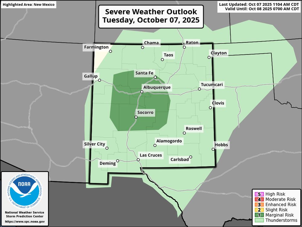
Heavy rains and scattered thunderstorms will bring a hail, isolated severe wind gusts, and localized flash flooding threat this afternoon and evening across parts of central New Mexico. This is the start of a multi-day period of thunderstorms and locally heavy rainfall across the Southwest.
WPC Day 1 Excessive Rainfall Outlook that highlights a marginal to slight risk for heavy rainfall and localized flash flooding across central and eastern New Mexico today mainly for areas near and south of I-40. SPC Day 1 Severe Weather Outlook that highlights the Marginal scattered thunderstorms threat across parts of central New Mexico.
nws.noaa.gov
Most flood fatalities occur in vehicles. It only takes 12in of water to sweep a car away.

Small decisions like turning around, not driving through a flooded roadway, around barricades, & delaying travel until conditions improve, can make a big impact.

Turn Around, Don’t Drown.
nws.noaa.gov
Tropical Storm #Jerry forms over the tropical central Atlantic. Here is the Key Message.
Tropical Storm Jerry Key messages, issued at 11:00 AM AST on Tuesday, October 7, 2025. The key message states that Tropical Storm Jerry is forecast to pass near or just north of the northern Leeward Islands on Thursday night and Friday. People in that area should monitor the storm for potential wind, surf, and rainfall impacts. Watches may be issued later today or tonight.

The graphic includes two maps:

Top-right map: A forecast cone showing the projected path of Tropical Storm Jerry, which moves west-northwest across the Atlantic, approaching the northern Leeward Islands by Thursday night.

Bottom-right map: A colored probability map displaying the likelihood of tropical-storm-force winds over the next 120 hours. 

For more information go to hurricanes.gov.
nws.noaa.gov
Heavy rain and storms are forecast across parts of the Ohio River Valley today. The slow moving nature of these storms combined with the possibility of backbuilding or training storms (when storms repeatedly develop over the same area) could lead to flash flooding. Check the forecast at weather.gov.
A weather graphic titled “Heavy Rain and Flood Threat – Tuesday, October 7, 2025”. 

The National Weather Service warns of heavy rainfall across Kentucky and the Ohio River Valley. A map on the top left shows rainfall amounts with colors indicating 2 to 4 inches of rain across Kentucky. A second map at the bottom right shows flash flood risk levels, with areas shaded in green (level 1 out of 4), yellow (level 2 out of 4).

Text on the graphic states:
“Heavy rain, of 2 to 4 inches, is forecast across Kentucky today.”
“A Level 2 out of 4 risk of excessive rain, which could lead to flash flooding, is in effect across parts of the Ohio River Valley through tonight.”
nws.noaa.gov
Periods of heavy rainfall today and tomorrow (Tuesday) could lead to isolated to scattered flash flooding across portions of the Ohio Valley and central Appalachians. Avoid flloded roadways and turn around, dont drown!

weather.gov
nws.noaa.gov
Mid 80s? In October? In Maine?! You betcha.

In addition to the record heat, gusty winds bring an elevated threat for wildfires through this afternoon.

weather.gov
nws.noaa.gov
Scattered showers and thunderstorms, some with locally very heavy rain, continue across the central Gulf Coast and Florida. A storm system will bring mountain snow, locally heavy rain, thunderstorms, gusty winds and much cooler temperatures to portions of the western and central U.S.
WPC National Forecast Chart for Sunday, October 5, 2025
nws.noaa.gov
Flood watches are already in effect along the East Coast of Florida through Sunday morning. Heavy rainfall rates could lead to rainfall totals of 3 to 5 inches in some areas.

Remember, never drive into flood waters, turn around, don't drown.
Keep up to date with the latest forecast at weather.gov.
Forecast heavy rainfall across Florida and the Southeast U.S. Friday morning through Monday morning, showing heavy rainfall forecast across the U.S. Southeast coast and eastern Florida coast.
nws.noaa.gov
Heavy rain and flooding is forecast along the East Coast of Florida into the coastal Southeast today through the weekend due to onshore flow.
nws.noaa.gov
Rip currents can sweep even the strongest swimmer away from shore. If at all possible, stay near a lifeguard while swimming. And if you get caught in a rip current, know these tips for how to survive.

For more safety tips visit weather.gov/safety.
These tips can help you survive if you get caught in a rip current.
nws.noaa.gov
The rip current risk will remain high across the Southeast and mid-Atlantic through the weekend.
Rip current risk is high across much of the Southeast and mid-Atlantic shoreline Friday October 3, 2025.
nws.noaa.gov
If coastal flooding is expected, be prepared. Elevate your belongings off the ground, move your car to higher ground, and have an evacuation plan.
weather.gov/safety
Prepare for coastal flooding. Elevate your belongings off of the ground. Move your car to higher ground. Have an evacuation plan.
nws.noaa.gov
📷Image: Map of current coastal hazards across the Southeast and East Coast coastlines.

Coastal flooding is defined as saltwater or freshwater inundation along the coast and can be caused by storm surge and onshore winds, high surf, or high astronomical tides. Get the latest forecast at: weather.gov
Map of coastal hazards from Florida to Maryland. Coastal flooding and high surf conditions are expected or occurring along  the Southeast and East Coast coastlines.
nws.noaa.gov
Heading out to the beach today? ⛱️

Use extra caution given the Moderate to High rip current risk from Florida to Maine today (October 2). Try to find a beach with lifeguards - and when in doubt, don't go out!
weather.gov/safety
Map showing the Rip Current Risk, today (October 2) across the southeast and eastern U.S. The map shows Moderate to High Risk of rip currents from Florida to Maine. Rip Currents: Know Your Options. Rip currents are powerful currents of water moving away from shore. They can sweep even the strongest swimmer away from shore. If at all possible, swim near a lifeguard. If caught in a rip current: 1) Relax, rip currents don't pull you under. 2) Don't swim against the current. 3) Swim out of the current, then to shore. 4) If you can't escape, float or tread water. 5) If you need help, yell or wave for assistance. The image shows a rip current as a narrow flow of water moving in a line directly away from the beach, with waves on either side moving in the opposite direction towards the beach. Arrows point away from either side of the current and into the waves, parallel to the beach, indicating the path of escape from the rip current.
nws.noaa.gov
Rip currents kill over 100 beach-goers in the U.S. each year. When visiting the ocean, you are safest at beaches with lifeguards. Stay #WeatherReady and learn more about rip current safety at weather.gov/safety/ripcurrent
nws.noaa.gov
Swells and high surf from Imelda are expected to produce dangerous marine conditions and rip currents along much of the East Coast of the United States during the next several days.
nws.noaa.gov
In addition, swells and high surf from both Humberto and Imelda are expected to produce dangerous marine conditions and rip currents along much of the East Coast of the United States during the next several days.

Visit hurricanes.gov for the latest.
nws.noaa.gov
Imelda is expected to bring damaging hurricane-force-winds to Bermuda when it passes near or over that island by Wednesday afternoon or evening. A Hurricane Warning is now in effect for
Bermuda.
nws.noaa.gov
Here's the latest forecast from the National Hurricane Center - hurricanes.gov

Fortunately, neither Tropical Storm Imelda or Hurricane Humberto are expected to make landfall along the U.S. coast. There are certainly rip current and marine impacts though.
Central Pacific Hurricane Center 2525 Correa Rd Suite 250 Honolulu, HI 96822 [email protected]
hurricanes.gov
nws.noaa.gov
Swells and high surf from both Humberto and Imelda are expected to produce dangerous marine conditions and rip currents along the east coast of Florida and the Georgia coast today (Sept. 29). These conditions will spread northward along much of the East Coast early this week.
weather.gov/safety
nws.noaa.gov
Quite a satellite image this morning! 🛰️🌀

Clouds extend 1000 miles from #Imelda's center all the way into central Pennsylvania.

#Humberto continues to churn in the Atlantic.
Visible satellite image of the East Coast and Atlantic showing the two tropical system.
nws.noaa.gov
Depression Becomes Tropical Storm Imelda.

Tropical Storm Conditions Expected Over the Central and Northwestern Bahamas This Afternoon and Evening.
hurricanes.gov
Central Pacific Hurricane Center 2525 Correa Rd Suite 250 Honolulu, HI 96822 [email protected]
hurricanes.gov
nws.noaa.gov
The National Hurricane Center Director Dr. Michael Brennan will provide a LIVE update on Tropical Depression Nine around 11:00 AM EDT today September 28, 2025. Please join us on Facebook Live and the NHC YouTube Page at: youtube.com/user/NWSNHC
hurricanes.gov
NOAA/NWS National Hurricane Center
NOAA/National Weather Service National Hurricane Center Miami, FL The National Weather Service (NWS) provides weather, hydrologic, and climate forecasts and warnings for the United States, its territ...
youtube.com
nws.noaa.gov
9/28 5am #TD9 Key Messages: Tropical storm conditions are expected across the central and NW #Bahamas today and possible along the east coast of central Florida on Monday. Rainfall can cause flooding for portions of #Cuba, Bahamas and portions of the SE U.S.

Details: hurricanes.gov
Key Messages for Tropical Depression Nine

1. The depression is expected to strengthen and bring tropical storm conditions to portions of the central and northwestern Bahamas through tonight. Tropical storm conditions are also possible along portions of the east coast of central Florida beginning Monday, where a Tropical Storm Watch is in effect.
 
2. Rainfall associated with Tropical Depression Nine will continue to impact eastern Cuba and the Bahamas through Tuesday, which will likely produce flash and urban flooding.  Mudslides are possible in 
the higher terrain.  Heavy rainfall across the coastal Carolinas 
could cause flash, urban, and river flooding into Wednesday 
morning. 
 
3. There is still a risk of heavy rainfall, wind and high surf 
impacts for the southeast U.S. coast even if the center 
remains offshore.  Residents should closely monitor the latest 
forecast updates and ensure that they have their hurricane plan in 
place.