NY State Weather Risk Communication Center
@nyswrcc.bsky.social
190 followers 15 following 46 posts
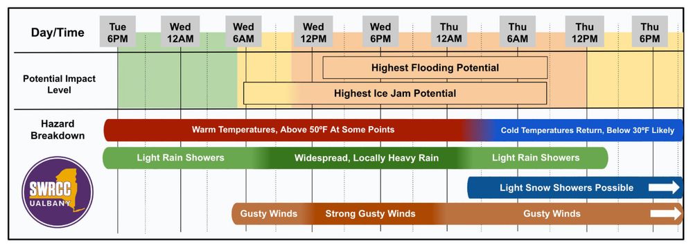
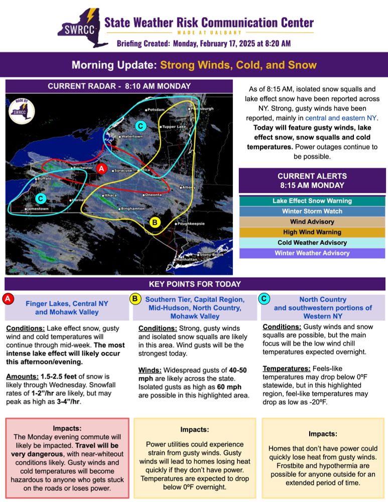
The State Weather Risk Communication Center at UAlbany is a partnership with the New York State Division of Homeland Security and Emergency Services, tasked with providing weather assistance to NY. www.albany.edu/state-weather-risk-communication-center
Posts Media Videos Starter Packs
nyswrcc.bsky.social
It was graduation day for our inaugural "Introduction to Weather Interpretation" course! EMs from across the state learned about weather and (weather) communication, culminating in a final "briefing" today.

We thank the EMs & great partners at NYS DHSES, NWS Albany, & @nysmesonet.org.
nyswrcc.bsky.social
Today we're beginning our very first class in our "Introduction to Weather Interpretation" course. This inaugural course will be conducted across four weeks and includes 16 emergency managers from across New York. We plan on more to come!
nyswrcc.bsky.social
NWS WPC has upgraded the Moderate Risk for flash flooding to include NYC, western Long Island and the Lower Hudson Valley. Moderate-to-heavy rainfall is expected this afternoon and evening, which will likely result in flooding.
nyswrcc.bsky.social
This morning our team hosted Governor Hochul and Commissioner Bray at our Center to discuss ways we can keep New Yorkers safe during extreme weather. Planning for a Texas-sized flood was a top concern.

After, Director Nick Bassill spoke alongside Governor Hochul & Commissioner Bray to the press.
nyswrcc.bsky.social
Over the last three days, there have been over 300 heat-related emergency department visits in #NYC, and 141 just yesterday (the most since at least 2016).

Why? Extreme, prolonged heat with no respite. Here's a map of consecutive hours of 85F+ feels-like temperatures. Almost 4 days straight!
nyswrcc.bsky.social
Yesterday was once again a record-breaking day across NY. Here are some of the "hot"-lights:

-Several long-running weather stations recorded their warmest ever June temperature, such as at JFK airport.
-The @nysmesonet.org network recorded their first ever 100F temperatures.
nyswrcc.bsky.social
While parts of upstate NY will start seeing relief from the heat, #NYC and much of downstate NY will be hot once more.

Overnight, parts of NYC never dipped below a 90F degree "feels-like" temperature. This was true for the the previous night too, which may compound health & infrastructure impacts.
nyswrcc.bsky.social
It's after 10PM and the temperatures across much of #NYC are *still* in the mid-90s. Thankfully, the humidity has abated somewhat, which should make many cooling units slightly more effective. However, for those without air conditioning, it's likely to be another oppressive evening.
nyswrcc.bsky.social
While it's not quite as humid today, temperatures are even warmer! At 3PM, much of eastern NY is near 100F.

Some long-running weather stations have broken records.

Nearly all of #NYC is between 97-100F right now, with even warmer feels-like temperatures.
nyswrcc.bsky.social
Extreme heat and power outages aren't a great combination. This map shows peak feels-like temperatures on Monday via the @nysmesonet.org as well as counties that peaked at 1,000 or more customer outages.
nyswrcc.bsky.social
Many high temperature and high heat index ("feels like") records were tied or broken across NY yesterday.

We've compiled these records for both traditional long-running stations ("ASOS") as well as NYS Mmesonet stations.

If you live in NY, it's likely you don't live far from a broken record!
nyswrcc.bsky.social
If you're in New York City and you're stepping out for work, to go vote, or just for a stroll ... it's possible you haven't experienced a below 90F feels-like temperature in over 24 hours. Today won't be any different.

Find a cooling center near you here: finder.nyc.gov/coolingcente...
nyswrcc.bsky.social
While hot temperatures affected all of NY on Monday, urban areas such as #NYC are feeling the brunt of the heatwave tonight. At midnight, most of NYC feels like its warmer than 90F while some locations even feel like 100F. Do whatever you can to stay cool tonight! Tomorrow will be hot once again.
nyswrcc.bsky.social
At 4PM, the feels-like temperature is likely near or just past its daily peak. It's been an oppressively hot day, and tomorrow will be similar.

Some of the preliminary "highlights":

Peak feels-like temperature: 117F, at Whitehall
Peak temperature: 100F, at Plattsburgh
nyswrcc.bsky.social
As of 1PM, the day's first 110F degree feels-like temperature has been observed. Numerous other stations are between 100-110F.

In fact, the NYS Mesonet's Ticonderoga station recorded a brand new all-time record high feels-like temperature of 113.7F just a few minutes ago! 🥵
nyswrcc.bsky.social
As of 10AM, the day's first 100F degree feels-like temperatures have already appeared at locations in the Hudson Valley.

Additionally, many of those in the Mohawk Valley still recovering from power outages over the weekend are already experiencing feels-like values around 90F.
nyswrcc.bsky.social
Last week SWRCC Staff presented on weather basics and protective actions for the Oswego County EMO & Oswego Health Department's “Cloudy Skies, Clear Messages: Effective Communication on Weather-Related Risks for Community Leaders” workshop. We love providing resources for our partners!
nyswrcc.bsky.social
Yesterday was an active weather day across western and central NY, with numerous active weather warnings and severe weather reports. Here's a summary of the activity from yesterday, though this may change as NWS teams inspect damage or gather additional reports.
nyswrcc.bsky.social
Yesterday certainly felt like summer across NY, given the hot temperatures and hazy skies. Here's a run-down of some of the hottest temperatures, which includes a number of broken records for areas across western and central NY.
nyswrcc.bsky.social
If it feels like it rains or snows every weekend, you might be right if you live in upstate NY.

You have to go all the way back to November 16th-17th, 2024 to find a weekend that was completely dry in Albany, Syracuse, and Saranac Lake. That's over 6 months ago!
nyswrcc.bsky.social
Here's the latest on today's severe thunderstorm threat, as of 830AM Tuesday. NWS SPC has continued an "enhanced" level of risk (level 3 out of 5), with strong winds, tornadoes, and large hail all possible. Storms will move from west to east this afternoon. #nywx
nyswrcc.bsky.social
Portions of western NY are under a rare "enhanced" risk for severe thunderstorms on Tuesday, with the greatest risk Tuesday evening. The last time a risk of this severity was issued at this lead time by NWS SPC for NY was in June of 2017. Our forecast summary is below ⬇️ #nywx
nyswrcc.bsky.social
This marks the 1st time in history that the SPC has issued a Day 4 Severe Weather Outlook for the greater NYC Region in March. Southeastern NY could experience impacts from severe weather Monday afternoon. Potential impacts include damaging winds, hail & localized urban flooding.
nyswrcc.bsky.social
A complex early spring storm will affect NY this week, bringing warmer temperatures and potentially isolated strong thunderstorms. Heavy rain combined with snow melt-water and possibly ice jams may produce localized flooding Wednesday and/or Thursday.
nyswrcc.bsky.social
If you're out and about today, be weather aware. A variety of hazards will impact travel and may induce power outages in your area. If you're in one of the 🔴, 🟡, or 🔵 zones below, check out the relevant key points.