OpenHistoricalMap
@openhistoricalmap.org
440 followers 1.7K following 76 posts
Explore the world throughout time, mapped in minute detail by people like you & dedicated to the public domain. OHM is a charter project of @osmus.bsky.social and cousin of @openstreetmap.bsky.social. #oldmaps #dh #hgis https://www.openhistoricalmap.org
Posts Media Videos Starter Packs
openhistoricalmap.org
We've set up some new networking rules on our sites, so if you're seeing any 503 or other errors, please DM and we'll fix things up! #NotYouBots
Reposted by OpenHistoricalMap
openhistoricalmap.org
In September, the #OpenHistoricalMap community added 78,430 dated elements, 10,580 buildings, and 20,439¼ railroad miles. The average age of a dated element fell by 21 months, and the average year shifted 17 months later. All this with the help of 30 new mappers – welcome!

osm.wiki/OHM/Statistics
OpenHistoricalMap/Statistics - OpenStreetMap Wiki
wiki.openstreetmap.org
openhistoricalmap.org
Yes, your georeferenced maps would be useful. You’d use them as reference layers, digitizing the depicted features. The only challenge is that a pre-digital map only represents a snapshot in time, so you’d need to qualify the dates with some uncertainty: wiki.openstreetmap.org/wiki/OpenHis...
OpenHistoricalMap/Tags - OpenStreetMap Wiki
wiki.openstreetmap.org
openhistoricalmap.org
Mabuhay! If you’re in Manila for #sotm #sotm2025, come find us for some troublemaker’s stickers!
Three stickers saying I map abandoned railways, boundaries you can’t see, and overlapping buildings like there’s no tomorrow: openhistoricalmap.org.
openhistoricalmap.org
I've reached out for a better answer than I can provide. Please ping me if you haven't heard back in a couple of days.
openhistoricalmap.org
I think we're all hyped!!
Reposted by OpenHistoricalMap
obrien.page
Help @maprva.org develop an historical street view of Richmond, VA by georeferencing old photographs! The catalog is actively growing and currently includes 1900 photos from the Library of Virginia and the @thevalentinerva.bsky.social

georeference.maprva.org
openhistoricalmap.org
But, before we get to all of our self-interested stuff, HUGE KUDOS to Jacob & the @maprva.org team. You guys should take a huge bow and deserve tremendous applause – this is an amazing amazing tool!!!!
openhistoricalmap.org
We'd love to help Jacob & others build these extensions, if there's interest. 🙏

And, of course, if anyone would like to keep improving the RVA section of OHM, we'd love to support that, too... just sayin'! 😎

www.openhistoricalmap.org#map=16/37.53...
openhistoricalmap.org
People are probably knocking down your door to add new features, but obviously... we'd love to see an OHM base map that matches the year of the picture, storage of your POIs in OHM, tagging of places in OHM... you name it!

www.openhistoricalmap.org/way/19947902...
openhistoricalmap.org
Love, love, *LOVE* this.

There's a fair amount of old RVA mapped already on OHM, and OHM has support for pictures, too, but this is a fantastic and easy to use integration. Can other cities might host their own versions?

#UrbanHistory #OldPhotos #OldMaps #GLAM #Richmond #HistoricalSociety
openhistoricalmap.org
¡Muchísimas gracias a @osm-colombia.bsky.social por la oportunidad de introducir #OpenHistoricalMap a los mapeadores latinoamericanos en #SOTMLatAm #SotMLatam2025 el sábado pasado! ¡Agradecemos el entusiasmo de todos y esperamos contar la geohistoria juntos!

commons.wikimedia.org/wiki/File:Ma...
commons.wikimedia.org
Reposted by OpenHistoricalMap
pseudo-isidore.bsky.social
Question for the medieval crowd: does anyone know of a good published map of Europe in 1066? (yes, I have googled)
openhistoricalmap.org
¡Buenas días de #Medellín y #SOTMLatAm #SotMLatam2025! ¡Agradecemos a encontrar todos los mapeadores aquí! @rub21.bsky.social y Minh Nguyễn van a presentar sobre la tema de #OpenHistoricalMap el sábado.
Un folleto de OpenHistoricalMap en un tablón de anuncios. Rubén y Minh en el vestíbulo de la biblioteca. Los folletos de OpenHistoricalMap y muchas pegatinas en la mesa de regalos.
openhistoricalmap.org
In August, the #OpenHistoricalMap community added 71,946 dated elements, 12,256 buildings, and 10,475¾ railroad miles. The average age of a dated element fell by 13 months, and the average year shifted 4 months later. All this with the help of 30 new contributors – welcome!

osm.wiki/OHM/Statistics
OpenHistoricalMap/Statistics - OpenStreetMap Wiki
wiki.openstreetmap.org
openhistoricalmap.org
Clues about history are never far and neither is @vespucci.io. With its new support for editing OHM, you can jot down what you learn from a #cornerstone #plaque #SidewalkStamp right on the spot, before the dates get jumbled around in your head.

vespucci.io/tutorials/sw...
Switching and adding OpenStreetMap data APIs - Vespucci
Main site for Vespucci the Android OpenStreetMap Editor
vespucci.io
Reposted by OpenHistoricalMap
opensourcesanjose.org
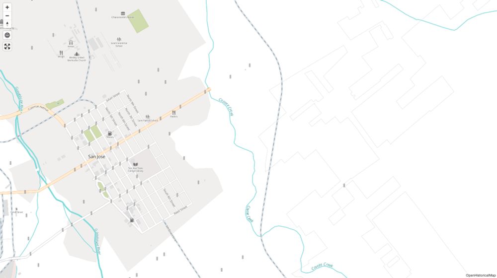
#SanJose is looking a little busier in #OpenHistoricalMap. Comprehensive historical coverage of #TrafficLights (courtesy of the city) makes it easier to tell where the major streets ran.

www.openhistoricalmap.org#map=15/37.33...

wiki.openstreetmap.org/wiki/OpenHis...

1960 and today:
In 1960, there were only a handful of traffic lights downtown. The city limits were starting to expand to the east. A railway line still ran north and south along the east side. Today, series of traffic lights indicate where major arterial streets run, such as Story and King roads. The Guadalupe and Sinclair freeways cut across the city, and a large interchange with the Bayshore Freeway dominates the right side of this map.
openhistoricalmap.org
Whether you go big or go small, you can’t map it all. But you can lay a foundation to grow and guide a new historical mapping community. Minh Nguyễn mixes as many metaphors as possible to show us how:

www.youtube.com/watch?v=5h3y...

#StateOfTheMapUS #SOTMUS
Shining a light: basic strategies for local historical mapping ~ Minh Nguyễn
YouTube video by OpenStreetMap US
www.youtube.com
openhistoricalmap.org
We’ve deployed a fix for the issue. Thank you for your patience this past week.
openhistoricalmap.org
In July, the #OpenHistoricalMap community added 55,883 dated elements, 13,636 buildings, and 19,387¼ railroad miles. The average age of a dated element fell by 13 months, and the average year shifted 5 months later. All this with the help of 29 new contributors – welcome!

osm.wiki/OHM/Statistics
OpenHistoricalMap/Statistics - OpenStreetMap Wiki
wiki.openstreetmap.org