Project Sidewalk
@projectsidewalk.bsky.social
33 followers 11 following 9 posts
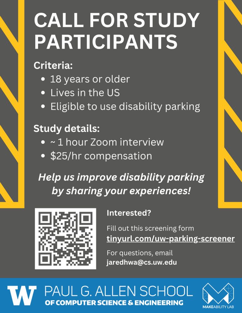
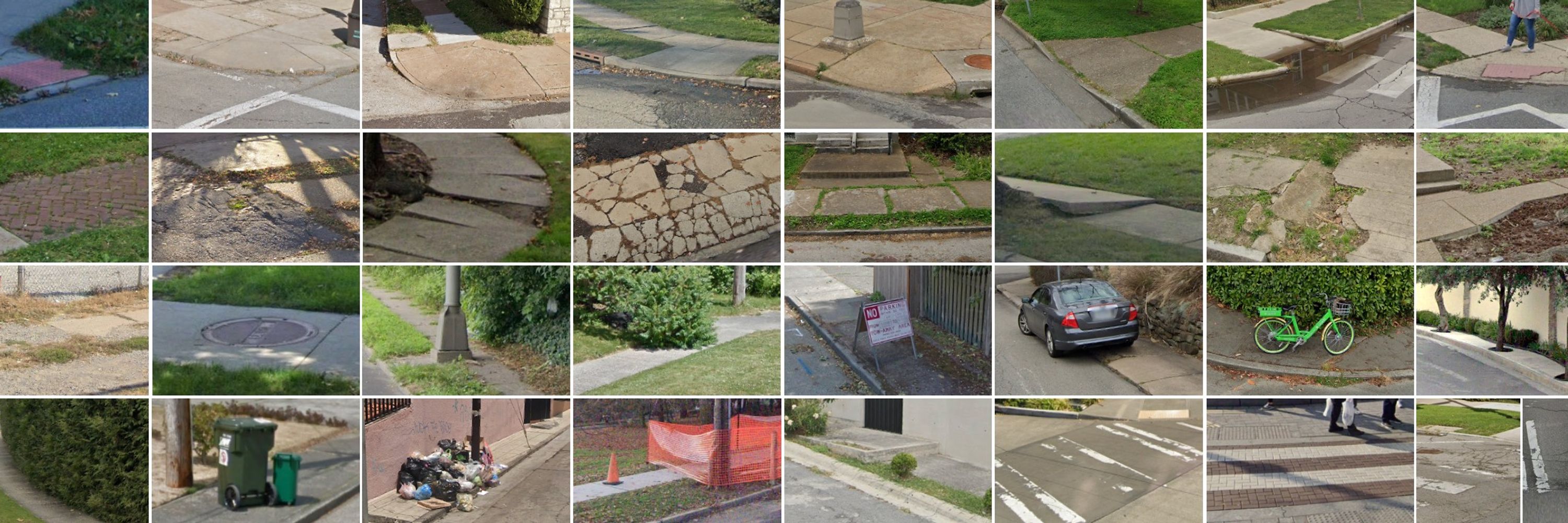
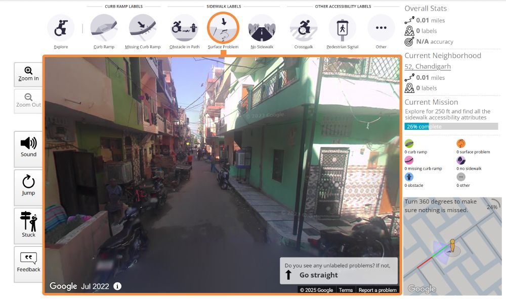
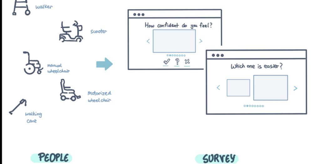
Our mission: map and assess the world's sidewalks using remote crowdsourcing, artificial intelligence, and online satellite & streetscape imagery. Let's make the world more walkable, rollable, and bikeable! Join us: https://projectsidewalk.org/
Posts Media Videos Starter Packs
projectsidewalk.bsky.social
We're now working on incorporating RampNet into Project Sidewalk. Let's go! 🚀 Shoutout to the whole team, including John, @jaredhwang.bsky.social, Zeyu Wang, and @ismikey.bsky.social. CC @uwcse.bsky.social

#Accessibility #AIforGood #OpenSource #ComputerVision #OpenData
projectsidewalk.bsky.social
Curb ramps are critical for mobility—for wheelchair users, parents with strollers, travelers with luggage. But detecting them automatically in images is an open problem. We've been working on automatic curb ramp detection for over 10 years, and RampNet significantly outperforms our prior work!
projectsidewalk.bsky.social
We're launching RampNet, an open-source AI that helps detect curb ramps with near-human accuracy.

The most amazing part? The entire project was conceived of and led by high school student John O'Meara.

🧵 A thread on what we built and why it matters.
The two-stage RampNet banner
projectsidewalk.bsky.social
In collaboration with Professor Anupam Sobti and students, we are excited to announce a new pilot deployment in India! 🎉This work furthers our research in mapping and assessing sidewalk accessibility across socio-cultural and geographic contexts: makeabilitylab.cs.washington.edu/media/public...
A screenshot of Project Sidewalk in India showing a narrow street with colorful buildings
Reposted by Project Sidewalk
jonfroehlich.bsky.social
📢 HUGE NEWS! Project Sidewalk just crossed 1.1 MILLION manual sidewalk accessibility annotations across 21,000+ km of streets! 🎉 (1,163,413 labels to be exact!). To celebrate and help others build on our work, we have posted a sidewalk feature/barrier dataset to @hf.co huggingface.co/projectsidew...
projectsidewalk.bsky.social
to use this unprecedented data to design, develop, and evaluate next-generation mapping tools.

We have mapped sidewalk accessibility in 28 cities across 8 countries including the US, Canada, Mexico, Ecuador, Netherlands, & New Zealand covering nearly 20,000km. Join us: projectsidewalk.org
Project Sidewalk
Your labels are used to improve city planning, build accessibility-aware mapping tools, and train machine learning algorithms to automatically find accessibility issues.
projectsidewalk.org
projectsidewalk.bsky.social
Hello! 👋 We are an open-source research project run by the @makeabilitylab.bsky.social. We have a two-pronged vision: first, to develop scalable data collection methods for sidewalk accessibility data using crowdsourcing, computer vision, and online map imagery; and second,
Reposted by Project Sidewalk
jaredhwang.bsky.social
⚠️ We're recruiting participants for a research study! We'd like to understand how people use disability parking. Fill out this screener if you fit the criteria, and we may reach out to interview you.

🔗 tinyurl.com/uw-parking-screener
💸 $25/hr compensation
Flyer soliciting research participants. It says: "Call for study participants. Criteria: 18 years or older, lives in the US, eligible to use disability parking. Study details: ~1 hour Zoom interview, $25 per hour compensation. Help us improve disability parking by sharing your experiences! Interested? Fill out this screening form tinyurl.com/uw-parking-screener. For questions, email jaredhwa@cs.uw.edu."

At the bottom of the flyer are the logos for the Paul G. Allen School of Computer Science & Engineering, styled as a large W with text to the side, and the Makeability Lab, styled as a large M with the text Makeability Lab underneath.