


Rorai Neto
@roraineto.bsky.social
Postdoc & lecturer at CULS Prague. I explore the combination of RS, photogrammetry, and data science to understand and monitor forest ecosystems. Passionate about teaching.
#RemoteSensing #LiDAR #Forestry #AI #DataScience #ForestMonitoring
🌲💻📡📊
#RemoteSensing #LiDAR #Forestry #AI #DataScience #ForestMonitoring
🌲💻📡📊
New paper
We explored how urban planning shapes urban forests in cities across southern Brazil using Planet imagery + landscape metrics .
#UrbanForests #RemoteSensing #UrbanPlanning #EcosystemServices #PlanetImagery #LandscapeEcology
onlinelibrary.wiley.com/doi/10.1002/...
We explored how urban planning shapes urban forests in cities across southern Brazil using Planet imagery + landscape metrics .
#UrbanForests #RemoteSensing #UrbanPlanning #EcosystemServices #PlanetImagery #LandscapeEcology
onlinelibrary.wiley.com/doi/10.1002/...

From the Capital to the Interior: Urban Planning's Impact on Forests and Landscape Metrics in South Brazil
Urban planning can show deficiencies in implementing infrastructure, especially green infrastructure, resulting in disparities between urban development, environmental quality, and quality of life. H...
onlinelibrary.wiley.com
August 6, 2025 at 1:59 PM
New paper
We explored how urban planning shapes urban forests in cities across southern Brazil using Planet imagery + landscape metrics .
#UrbanForests #RemoteSensing #UrbanPlanning #EcosystemServices #PlanetImagery #LandscapeEcology
onlinelibrary.wiley.com/doi/10.1002/...
We explored how urban planning shapes urban forests in cities across southern Brazil using Planet imagery + landscape metrics .
#UrbanForests #RemoteSensing #UrbanPlanning #EcosystemServices #PlanetImagery #LandscapeEcology
onlinelibrary.wiley.com/doi/10.1002/...
🌲 #Forests🌲 New special issue is online: "#Detection and #Identification of #Forest #Cover Change", guest edited by Dr. Marcos Benedito Schimalski, Dr. Veraldo Liesenberg and Dr. Rorai Pereira Martins-Neto
👉 brnw.ch/21wTmzD
🌴 #remotesensing #sensors #machinelearning
👉 brnw.ch/21wTmzD
🌴 #remotesensing #sensors #machinelearning

July 17, 2025 at 7:39 PM
🌲 #Forests🌲 New special issue is online: "#Detection and #Identification of #Forest #Cover Change", guest edited by Dr. Marcos Benedito Schimalski, Dr. Veraldo Liesenberg and Dr. Rorai Pereira Martins-Neto
👉 brnw.ch/21wTmzD
🌴 #remotesensing #sensors #machinelearning
👉 brnw.ch/21wTmzD
🌴 #remotesensing #sensors #machinelearning
Interview I gave about the award I received from Forests MDPI for best paper published in 2023. The interview was done by Unesp in Presidente Prudente, the university where I did my Ph.D
www.fct.unesp.br/sharer.php?n...
www.fct.unesp.br/sharer.php?n...

Egresso do PPGCC da FCT Unesp recebe prêmio por tese de destaque
www.fct.unesp.br
May 27, 2025 at 3:12 PM
Interview I gave about the award I received from Forests MDPI for best paper published in 2023. The interview was done by Unesp in Presidente Prudente, the university where I did my Ph.D
www.fct.unesp.br/sharer.php?n...
www.fct.unesp.br/sharer.php?n...
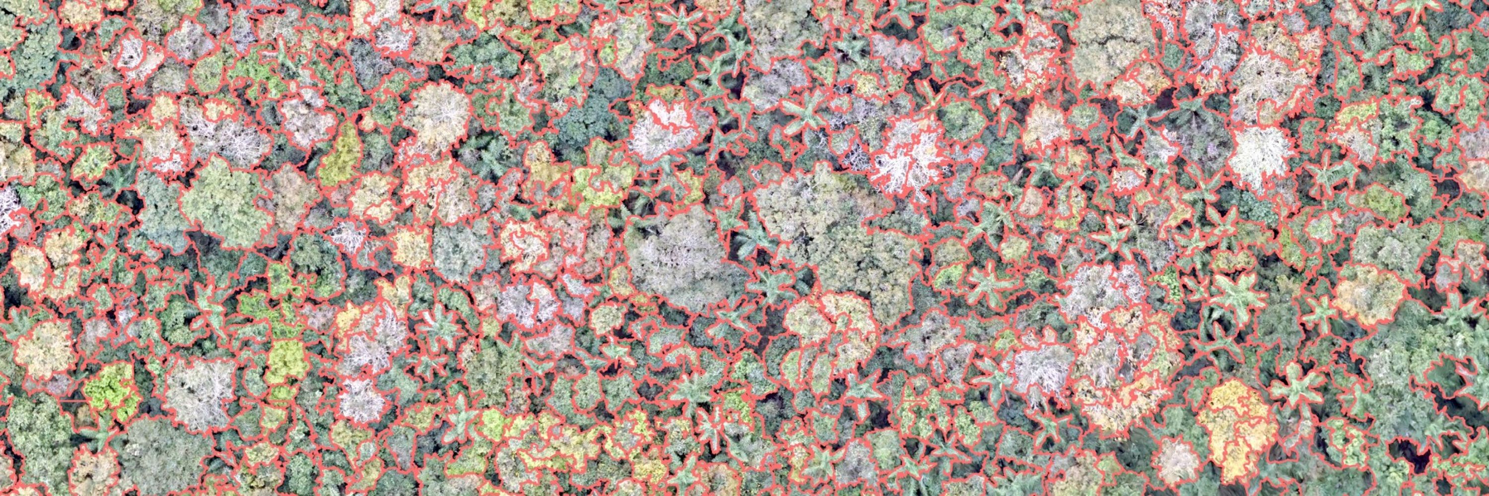
I had the opportunity to be part of this incredible paper with a great team.

🌲 What can close-range LiDAR devices tell us about our forests?
In our last #RSE article, we explore the role of close-range LiDAR devices in operational forest inventories at stand level through the statistical inference approach.
www.sciencedirect.com/science/arti...
In our last #RSE article, we explore the role of close-range LiDAR devices in operational forest inventories at stand level through the statistical inference approach.
www.sciencedirect.com/science/arti...

Use of close-range LiDAR devices and statistical inference approaches in operational stand-level forest inventories
Close-range LiDAR devices are considered to have great potential for enhancing forest inventory (FI) estimates. However, this potential is still being…
www.sciencedirect.com
May 3, 2025 at 9:32 PM
I had the opportunity to be part of this incredible paper with a great team.
Reposted by Rorai Neto

► Matéria inédita ◄
Metais pesados contaminam 17% das terras agrícolas globais
Pesquisa revela que 17% dos solos agrícolas mundiais estão contaminados por metais pesados tóxicos, colocando 1,4 bilhão de pessoas em risco
tinyurl.com/3u7hrjkt
Metais pesados contaminam 17% das terras agrícolas globais
Pesquisa revela que 17% dos solos agrícolas mundiais estão contaminados por metais pesados tóxicos, colocando 1,4 bilhão de pessoas em risco
tinyurl.com/3u7hrjkt

Metais pesados contaminam 17% das terras agrícolas globais
Pesquisa revela que 17% dos solos agrícolas mundiais estão contaminados por metais pesados tóxicos, colocando 1,4 bilhão de pessoas em risco
tinyurl.com
April 19, 2025 at 12:34 PM
► Matéria inédita ◄
Metais pesados contaminam 17% das terras agrícolas globais
Pesquisa revela que 17% dos solos agrícolas mundiais estão contaminados por metais pesados tóxicos, colocando 1,4 bilhão de pessoas em risco
tinyurl.com/3u7hrjkt
Metais pesados contaminam 17% das terras agrícolas globais
Pesquisa revela que 17% dos solos agrícolas mundiais estão contaminados por metais pesados tóxicos, colocando 1,4 bilhão de pessoas em risco
tinyurl.com/3u7hrjkt
Reposted by Rorai Neto
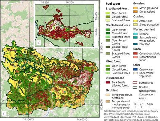
Effect of bark beetle disturbance on fire dynamics in Central Europe 🪲🔥
Beetz et al. found that forest stands with previous bark beetle infestations had larger areas of very high burn severity and more extreme fire intensities than most other fuel types.
Read more here 👇
doi.org/10.1093/fore...
Beetz et al. found that forest stands with previous bark beetle infestations had larger areas of very high burn severity and more extreme fire intensities than most other fuel types.
Read more here 👇
doi.org/10.1093/fore...
April 15, 2025 at 4:25 PM
Effect of bark beetle disturbance on fire dynamics in Central Europe 🪲🔥
Beetz et al. found that forest stands with previous bark beetle infestations had larger areas of very high burn severity and more extreme fire intensities than most other fuel types.
Read more here 👇
doi.org/10.1093/fore...
Beetz et al. found that forest stands with previous bark beetle infestations had larger areas of very high burn severity and more extreme fire intensities than most other fuel types.
Read more here 👇
doi.org/10.1093/fore...