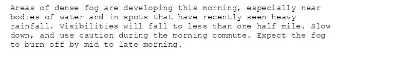
Alerts from NWS Louisville KY (UNOFFICIAL)
@sdf.nws-bot.us
1.3K followers 1 following 2.8K posts
Unofficial bot sharing alerts from NWS Louisville KY. This account is not monitored. Contact @wandrme.paxex.aero if needed.
Posts Media Videos Starter Packs
sdf.nws-bot.us
🚨 Flood Warning issued October 8 at 12:12PM EDT until October 8 at 11:42PM EDT by NWS Louisville KY 🚨
Additional Details Here.
...The Flood Warning is extended for the following rivers in
Kentucky...

Stoner Creek at Paris affecting Bourbon County.

.Heavy rain from the past 36 hours has caused the river to rise.

* WHAT...Minor flooding is occurring and minor flooding is forecast.

* WHERE...Stoner Creek at Paris.

* WHEN...Until late this evening.

* IMPACTS...At 18.0 feet, Water floods a few low roads on right bank
of creek.
At 20.0 feet, Water enters yards of homes downstream of water
plant. Parts of the Garrard Park flood.

* ADDITIONAL DETAILS...
- At 11:15 AM EDT Wednesday the stage was 18.5 feet.
- Bankfull stage is 18.0 feet.
- Recent Activity...The maximum river stage in the 24 hours
ending at 11:15 AM EDT Wednesday was 18.5 feet.
- Forecast...The river is expected to fall below flood stage
late this afternoon and continue falling to 13.1 feet early
Friday morning.
- Flood stage is 18.0 feet.
- Flood History...This crest compares to a previous crest of
18.5 feet on 02/13/2020.
- http://www.weather.gov/safety/flood
sdf.nws-bot.us
🚨 Flood Warning issued October 8 at 5:41AM EDT until October 8 at 8:08PM EDT by NWS Louisville KY 🚨
Additional Details Here.
...The National Weather Service in Louisville KY has issued a Flood
Warning for the following rivers in Kentucky...

Stoner Creek at Paris affecting Bourbon County.

.Heavy rain from Tuesday has caused the river to rise.

* WHAT...Minor flooding is forecast.

* WHERE...Stoner Creek at Paris.

* WHEN...Until this evening.

* IMPACTS...At 18.0 feet, Water floods a few low roads on right bank
of creek.
At 20.0 feet, Water enters yards of homes downstream of water
plant. Parts of the Garrard Park flood.

* ADDITIONAL DETAILS...
- At 5:15 AM EDT Wednesday the stage was 17.9 feet.
- Bankfull stage is 18.0 feet.
- Forecast...The river is expected to rise above flood stage
this morning to a crest of 18.4 feet late this morning. It
will then fall below flood stage this afternoon.
- Flood stage is 18.0 feet.
- Flood History...No available flood history.
- http://www.weather.gov/safety/flood
sdf.nws-bot.us
Flood Advisory issued October 8 at 4:39AM EDT until October 9 at 6:00AM EDT by NWS Louisville KY
Additional Details Here.
...The National Weather Service in Louisville has issued a Flood
Advisory for the following rivers in Kentucky...

Stoner Creek at Paris affecting Bourbon County.

.Heavy rain from Tuesday has caused the river to rise.

* WHAT...Flooding caused by excessive rainfall is expected.

* WHERE...Stoner Creek at Paris.

* WHEN...From early this morning to tomorrow morning.

* IMPACTS...At 18.0 feet, Water floods a few low roads on right bank
of creek.

* ADDITIONAL DETAILS...
- At 4:15 AM EDT Wednesday the stage was 17.6 feet.
- Bankfull stage is 18.0 feet.
- Forecast...The river is expected to rise to a crest of 17.9
feet this morning.
- Action stage is 16.0 feet.
- Flood stage is 18.0 feet.
- http://www.weather.gov/safety/flood
sdf.nws-bot.us
🚨 Flood Warning issued October 7 at 3:52PM EDT until October 7 at 7:00PM EDT by NWS Louisville KY 🚨
Additional Details Here.
* WHAT...Flooding caused by excessive rainfall is expected.

* WHERE...A portion of central Kentucky, including the following
counties, Bourbon, Clark and Fayette.

* WHEN...Until 700 PM EDT.

* IMPACTS...Flooding of rivers, creeks, streams, and other low-lying
and flood-prone locations is imminent or occurring.

* ADDITIONAL DETAILS...
- At 352 PM EDT, Doppler radar indicated heavy rain. Flooding
is ongoing or expected to begin shortly in the warned area.
Between 3 and 4 inches of rain have fallen.
- Additional rainfall amounts of 0.5 to 1.5 inches are possible
in the warned area.
- Some locations that will experience flooding include...
Winchester, Paris, North Middletown, Pretty Run, Renick,
Stony Point, Austerlitz, Silver Lake, Constant Station and
Escondida.
- http://www.weather.gov/safety/flood
sdf.nws-bot.us
Flood Advisory issued October 7 at 2:54PM EDT until October 7 at 6:00PM EDT by NWS Louisville KY
Additional Details Here.
* WHAT...Flooding caused by excessive rainfall is expected.

* WHERE...Portions of south central Indiana, including the following
county, Harrison and central Kentucky, including the following
counties, Breckinridge, Bullitt, Hardin, Jefferson, Meade and
Nelson.

* WHEN...Until 600 PM EDT /500 PM CDT/.

* IMPACTS...Minor flooding in low-lying and poor drainage areas.
Overflowing poor drainage areas.

* ADDITIONAL DETAILS...
- At 251 PM EDT /151 PM CDT/, Doppler radar indicated heavy
rain due to thunderstorms. Minor flooding is ongoing in the
advisory area. Between 1 and 4 inches of rain have fallen.
- Additional rainfall amounts up to 0.5 inches are expected
over the area.
- Some locations that will experience flooding include...
Bardstown, Shepherdsville, Radcliff, Mount Washington,
Hillview, Vine Grove, Lebanon Junction, Muldraugh, West Point
and Fox Chase.
- http://www.weather.gov/safety/flood
sdf.nws-bot.us
🚨 Flash Flood Warning issued October 7 at 2:33PM EDT until October 7 at 6:30PM EDT by NWS Louisville KY 🚨
Additional Details Here.
FFWLMK

The National Weather Service in Louisville has issued a

* Flash Flood Warning for...
Fayette County in central Kentucky...

* Until 630 PM EDT.

* At 233 PM EDT, Doppler radar indicated thunderstorms producing
heavy rain across the warned area. Between 1 and 3 inches of rain
have fallen. Additional rainfall amounts of 0.5 to 2.0 inches are
possible in the warned area. Flash flooding is ongoing or expected
to begin shortly.

HAZARD...Flash flooding caused by thunderstorms.

SOURCE...Radar.

IMPACT...Flash flooding of small creeks and streams, urban
areas, highways, streets and underpasses as well as
other poor drainage and low-lying areas.

* Some locations that will experience flash flooding include...
Lexington, Northland, Chevy Chase, Thoroughbred Acres, Cadentown,
U K Arboretum, Bryan Station, Highlands, Meadowthorpe and Cardinal
Hill.
sdf.nws-bot.us
🚨 Flood Warning issued October 7 at 2:14PM EDT until October 7 at 6:30PM EDT by NWS Louisville KY 🚨
Additional Details Here.
* WHAT...Flooding caused by excessive rainfall is expected.

* WHERE...A portion of central Kentucky, including the following
counties, Bullitt and Jefferson.

* WHEN...Until 630 PM EDT.

* IMPACTS...Flooding of rivers, creeks, streams, and other low-lying
and flood-prone locations is imminent or occurring.

* ADDITIONAL DETAILS...
- At 212 PM EDT, Doppler radar indicated heavy rain due to
thunderstorms. Flooding is ongoing in parts of Louisville but
should improve as rain moves out. Between 2 and 5 inches of
rain have fallen.
- Additional rainfall amounts up to 0.5 inches are possible in
the warned area.
- Some locations that will experience flooding include...
Louisville, Jeffersonville, New Albany, Jeffersontown, St.
Matthews, Shively, Lyndon, Middletown, Douglass Hills and
Hurstbourne.
- http://www.weather.gov/safety/flood
sdf.nws-bot.us
🚨 Flood Warning issued October 7 at 1:25PM EDT until October 7 at 7:30PM EDT by NWS Louisville KY 🚨
Additional Details Here.
* WHAT...Flooding caused by excessive rainfall is expected.

* WHERE...A portion of central Kentucky, including the following
counties, Anderson, Franklin, Henry, Mercer, Nelson, Scott,
Shelby, Spencer, Washington and Woodford.

* WHEN...Until 730 PM EDT Tuesday.

* IMPACTS...Flooding of rivers, creeks, streams, and other low-lying
and flood-prone locations is imminent or occurring.

* ADDITIONAL DETAILS...
- At 124 PM EDT, Doppler radar indicated heavy rain due to
thunderstorms. Flooding is ongoing or expected to begin
shortly in the warned area. Between 1.5 and 3.0 inches of
rain have fallen.
- Additional rainfall amounts of 0.5 to 1.5 inches are possible
in the warned area.
- Some locations that will experience flooding include...
Frankfort, Bardstown, Lawrenceburg, Versailles, Taylorsville,
Ballard, Midway, Bloomfield, Willisburg and Fairfield.
- http://www.weather.gov/safety/flood
sdf.nws-bot.us
Flood Advisory issued October 7 at 12:52PM EDT until October 7 at 6:45PM EDT by NWS Louisville KY
Additional Details Here.
* WHAT...Flooding caused by excessive rainfall is expected.

* WHERE...Portions of south central Indiana, including the following
counties, Clark and Floyd and central Kentucky, including the
following counties, Henry, Oldham, Shelby and Trimble.

* WHEN...Until 645 PM EDT.

* IMPACTS...Minor flooding in low-lying and poor drainage areas.

* ADDITIONAL DETAILS...
- At 1252 PM EDT, Doppler radar indicated heavy rain due to
thunderstorms. Minor flooding is ongoing or expected to begin
shortly in the advisory area. Between 0.5 and 2 inches of
rain have fallen.
- Additional rainfall amounts of 0.5 to 1.5 inches are expected
over the area. This additional rain will result in minor
flooding.
- Some locations that will experience flooding include...
Madison, La Grange, New Castle, Bedford, Pendleton,
Charlestown, Sellersburg, Eminence, Owen and Goshen.
- http://www.weather.gov/safety/flood
sdf.nws-bot.us
Flood Advisory issued October 7 at 12:32PM EDT until October 7 at 6:30PM EDT by NWS Louisville KY
Additional Details Here.
* WHAT...Flooding caused by excessive rainfall is expected.

* WHERE...A portion of central Kentucky, including the following
counties, Bourbon, Clark, Fayette, Franklin, Harrison, Jessamine,
Mercer, Nicholas, Scott and Woodford.

* WHEN...Until 630 PM EDT.

* IMPACTS...Minor flooding in low-lying and poor drainage areas.

* ADDITIONAL DETAILS...
- At 1232 PM EDT, Doppler radar indicated heavy rain due to
thunderstorms. Minor flooding is ongoing or expected to begin
shortly in the advisory area. Between 0.5 and 2 inches of
rain have fallen.
- Additional rainfall amounts of 1 to 2 inches are expected
over the area. This additional rain will result in minor
flooding.
- Some locations that will experience flooding include...
Lexington, Georgetown, Nicholasville, Winchester, Versailles,
Paris, Cynthiana, Carlisle, Bryan Station and Thoroughbred
Acres.
- http://www.weather.gov/safety/flood
sdf.nws-bot.us
🚨 Flash Flood Warning issued October 7 at 12:03PM EDT until October 7 at 6:00PM EDT by NWS Louisville KY 🚨
Additional Details Here.
FFWLMK

The National Weather Service in Louisville has issued a

* Flash Flood Warning for...
Northeastern Bullitt County in central Kentucky...
East Central Jefferson County in central Kentucky...
Shelby County in central Kentucky...
Northern Spencer County in central Kentucky...

* Until 600 PM EDT.

* At 1203 PM EDT, Doppler radar indicated thunderstorms producing
heavy rain across the warned area. Between 1.5 and 3 inches of
rain have fallen. Additional rainfall amounts of 0.5 to 1.5 inches
are possible in the warned area. Flash flooding is ongoing or
expected to begin shortly.

HAZARD...Flash flooding caused by thunderstorms.

SOURCE...Radar.

IMPACT...Flash flooding of small creeks and streams, urban
areas, highways, streets and underpasses as well as
other poor drainage and low-lying areas.

* Some locations that will experience flash flooding include...
Shelbyville, Taylorsville, Mount Washington, Simpsonville, Olive
Branch, Finchville, Veech, Joyes, Rivals and Middletown Heights.
sdf.nws-bot.us
🚨 Flash Flood Warning issued October 7 at 12:14PM EDT until October 7 at 2:15PM EDT by NWS Louisville KY 🚨
Additional Details Here.
At 1214 PM EDT, Louisville Jefferson County Emergency Management
reported thunderstorms producing heavy rain in Louisville. Between 2
and 4 inches of rain have fallen. Additional rainfall amounts of 0.5
to 1 inch are possible in the warned area. Flash flooding is already
occurring.

HAZARD...Life threatening flash flooding. Thunderstorms producing
flash flooding.

SOURCE...Emergency management reported.

IMPACT...Life threatening flash flooding of creeks and streams,
urban areas, highways, streets and underpasses.

Some locations that will experience flash flooding include...
Louisville, New Albany, Jeffersontown, St. Matthews, Shively,
Lyndon, Middletown, Douglass Hills, Hurstbourne and Windy Hills.

There have been several reports of water-related calls for service
across Louisville.
sdf.nws-bot.us
Flood Advisory issued October 7 at 11:51AM EDT until October 7 at 5:45PM EDT by NWS Louisville KY
Additional Details Here.
* WHAT...Flooding caused by excessive rainfall is expected.

* WHERE...A portion of central Kentucky, including the following
counties, Anderson, Breckinridge, Bullitt, Grayson, Hardin, Larue,
Marion, Mercer, Nelson, Washington and Woodford.

* WHEN...Until 545 PM EDT /445 PM CDT/.

* IMPACTS...Minor flooding in low-lying and poor drainage areas.

* ADDITIONAL DETAILS...
- At 1151 AM EDT /1051 AM CDT/, Doppler radar and automated
rain gauges indicated heavy rain due to thunderstorms. Minor
flooding is ongoing or expected to begin shortly in the
advisory area. Between 1 and 2 inches of rain have fallen.
- Additional rainfall amounts of 0.5 to 1.5 inches are expected
over the area. This additional rain will result in minor
flooding.
- Some locations that will experience flooding include...
Elizabethtown, Bardstown, Harrodsburg, Hodgenville,
Springfield, Radcliff, Lebanon Junction, New Haven, Loretto
and Sonora.
- http://www.weather.gov/safety/flood
sdf.nws-bot.us
🚨 Flood Warning issued October 7 at 11:29AM EDT until October 7 at 5:30PM EDT by NWS Louisville KY 🚨
Additional Details Here.
* WHAT...Flooding caused by excessive rainfall is expected.

* WHERE...A portion of south central Indiana, including the
following counties, Floyd and Harrison.

* WHEN...Until 530 PM EDT Tuesday.

* IMPACTS...Flooding of rivers, creeks, streams, and other low-lying
and flood-prone locations is imminent or occurring.

* ADDITIONAL DETAILS...
- At 1129 AM EDT, Doppler radar indicated heavy rain due to
thunderstorms. Flooding is ongoing or expected to begin
shortly in the warned area. Between 2 and 4 inches of rain
have fallen.
- Additional rainfall amounts of 0.5 to 1.5 inches are possible
in the warned area.
- Some locations that will experience flooding include...
Corydon, Elizabeth, New Middletown, Mauckport, Laconia, New
Amsterdam, Dogwood, Seven Springs, Central and Breckenridge.
- http://www.weather.gov/safety/flood
sdf.nws-bot.us
🚨 Flood Warning issued October 7 at 11:25AM EDT until October 7 at 5:30PM EDT by NWS Louisville KY 🚨
Additional Details Here.
* WHAT...Flooding caused by excessive rainfall is expected.

* WHERE...Portions of south central Indiana, including the following
counties, Crawford and Perry and central Kentucky, including the
following counties, Breckinridge, Hancock and Meade.

* WHEN...Until 530 PM EDT /430 PM CDT/ Tuesday.

* IMPACTS...Flooding of rivers, creeks, streams, and other low-lying
and flood-prone locations is imminent or occurring.

* ADDITIONAL DETAILS...
- At 1125 AM EDT /1025 AM CDT/, Doppler radar and automated
rain gauges indicated heavy rain due to thunderstorms.
Flooding is ongoing or expected to begin shortly in the
warned area. Between 2 and 4 inches of rain have fallen.
- Additional rainfall amounts of 0.5 to 1 inch are possible in
the warned area.
- Some locations that will experience flooding include...
Tell City, Brandenburg, Hardinsburg, Hawesville, Webster,
Lewisport, Cannelton, Irvington, Cloverport and Troy.
- http://www.weather.gov/safety/flood
sdf.nws-bot.us
Flood Advisory issued October 7 at 11:03AM EDT until October 7 at 5:00PM EDT by NWS Louisville KY
Additional Details Here.
* WHAT...Flooding caused by excessive rainfall is expected.

* WHERE...A portion of central Kentucky, including the following
counties, Anderson, Franklin, Henry, Mercer, Nelson, Shelby,
Spencer, Washington and Woodford.

* WHEN...Until 500 PM EDT.

* IMPACTS...Minor flooding in low-lying and poor drainage areas.

* ADDITIONAL DETAILS...
- At 1103 AM EDT, Doppler radar indicated heavy rain due to
thunderstorms. Minor flooding is ongoing or expected to begin
shortly in the advisory area. Between 0.5 and 2 inches of
rain have fallen.
- Additional rainfall amounts of 1 to 2 inches are expected
over the area. This additional rain will result in minor
flooding.
- Some locations that will experience flooding include...
Frankfort, Lawrenceburg, Versailles, Ballard, Eminence,
Pleasureville, Willisburg, Graefenburg, Bridgeport and
Avenstoke.
- http://www.weather.gov/safety/flood
sdf.nws-bot.us
🚨 Flash Flood Warning issued October 7 at 11:14AM EDT until October 7 at 2:15PM EDT by NWS Louisville KY 🚨
Additional Details Here.
FFWLMK

The National Weather Service in Louisville has issued a

* Flash Flood Warning for...
Northern Bullitt County in central Kentucky...
Jefferson County in central Kentucky...

* Until 215 PM EDT.

* At 1114 AM EDT, Doppler radar and automated rain gauges indicated
thunderstorms producing heavy rain across the warned area. Between
2 and 3 inches of rain have fallen. Additional rainfall amounts of
0.5 to 2 inches are possible in the warned area. Flash flooding is
already occurring.

HAZARD...Life threatening flash flooding. Thunderstorms
producing flash flooding.

SOURCE...Radar and automated gauges.

IMPACT...Life threatening flash flooding of creeks and streams,
urban areas, highways, streets and underpasses.

* Some locations that will experience flash flooding include...
Louisville, New Albany, Jeffersontown, St. Matthews, Shively,
Lyndon, Middletown, Douglass Hills, Hurstbourne and Windy Hills.
sdf.nws-bot.us
Flood Advisory issued October 7 at 8:50AM EDT until October 7 at 2:45PM EDT by NWS Louisville KY
Additional Details Here.
* WHAT...Flooding caused by excessive rainfall is expected.

* WHERE...Portions of south central Indiana, including the following
counties, Clark, Crawford, Floyd, Harrison and Perry and central
Kentucky, including the following counties, Breckinridge, Bullitt,
Hancock, Hardin, Jefferson, Meade, Nelson, Ohio, Oldham, Shelby
and Spencer.

* WHEN...Until 245 PM EDT /145 PM CDT/.

* IMPACTS...Minor flooding in low-lying and poor drainage areas.
Ponding of water in urban or other areas is occurring or is
imminent.

* ADDITIONAL DETAILS...
- At 850 AM EDT /750 AM CDT/, Doppler radar and automated rain
gauges indicated heavy rain due to thunderstorms. Minor
flooding is ongoing or expected to begin shortly in the
advisory area. Between 1 and 2.5 inches of rain have fallen.
- Additional rainfall amounts of 1 to 3 inches are expected
over the area. This additional rain will result in minor
flooding.
- Some locations that will experience flooding include...
Louisville, Jeffersonville, New Albany, Jeffersontown, St.
Matthews, Shively, Shelbyville, Bardstown, Shepherdsville and
Lyndon.
- http://www.weather.gov/safety/flood
sdf.nws-bot.us
Dense Fog Advisory issued September 26 at 4:51AM EDT until September 26 at 10:00AM EDT by NWS Louisville KY
Additional Details Here.
* WHAT...Visibility down to one quarter mile or less in dense fog.

* WHERE...Portions of Indiana and east central, north central, and
south central Kentucky.

* WHEN...Until 10 AM EDT /9 AM CDT/ this morning.

* IMPACTS...Low visibility could make driving conditions hazardous.
sdf.nws-bot.us
Special Weather Statement issued September 26 at 4:17AM EDT by NWS Louisville KY
Additional Details Here.
Areas of dense fog are developing this morning, especially near
bodies of water and in spots that have recently seen heavy
rainfall. Visibilities will fall to less than one half mile. Slow
down, and use caution during the morning commute. Expect the fog
to burn off by mid to late morning.
sdf.nws-bot.us
Flood Advisory issued September 25 at 10:57AM EDT until September 25 at 1:00PM EDT by NWS Louisville KY
Additional Details Here.
* WHAT...Flooding caused by excessive rainfall is expected.

* WHERE...A portion of central Kentucky, including the following
county, Trimble.

* WHEN...Until 100 PM EDT.

* IMPACTS...Minor flooding in low-lying and poor drainage areas.

* ADDITIONAL DETAILS...
- At 1057 AM EDT, Doppler radar indicated heavy rain due to
thunderstorms. Minor flooding is ongoing or expected to begin
shortly in the advisory area. Between 1 and 2 inches of rain
have fallen.
- Some locations that will experience flooding include...
Madison, Milton, Trout and Monitor.
- http://www.weather.gov/safety/flood
sdf.nws-bot.us
Flood Advisory issued September 25 at 8:59AM EDT until September 25 at 12:00PM EDT by NWS Louisville KY
Additional Details Here.
* WHAT...Flooding caused by excessive rainfall is expected.

* WHERE...A portion of south central Indiana, including the
following counties, Clark and Washington.

* WHEN...Until noon EDT.

* IMPACTS...Minor flooding in low-lying and poor drainage areas.

* ADDITIONAL DETAILS...
- At 859 AM EDT, Doppler radar indicated heavy rain due to
thunderstorms. Minor flooding is ongoing or expected to begin
shortly in the advisory area. Between 1 and 2 inches of rain
have fallen.
- Some locations that will experience flooding include...
Clarksville, Charlestown, Sellersburg, Blue River, New Pekin,
Borden, Bethlehem, Memphis, Henryville and Blue Lick.
- http://www.weather.gov/safety/flood
sdf.nws-bot.us
Flood Advisory issued September 25 at 1:56AM EDT until September 25 at 5:00AM EDT by NWS Louisville KY
Additional Details Here.
* WHAT...Flooding caused by excessive rainfall is expected.

* WHERE...A portion of central Kentucky, including the following
counties, Harrison and Nicholas.

* WHEN...Until 500 AM EDT.

* IMPACTS...Minor flooding in low-lying and poor drainage areas.
Water over roadways.

* ADDITIONAL DETAILS...
- At 156 AM EDT, Doppler radar indicated heavy rain due to
thunderstorms. Minor flooding is ongoing or expected to begin
shortly in the advisory area. Between 1.5 and 2 inches of
rain have fallen.
- Additional rainfall amounts of 0.5 to 1 inch are expected
over the area. This additional rain will result in minor
flooding.
- Some locations that will experience flooding include...
Sunrise, Claysville, Oddville and Antioch.
- http://www.weather.gov/safety/flood
sdf.nws-bot.us
Special Weather Statement issued September 24 at 11:57PM CDT by NWS Louisville KY
Additional Details Here.
At 1157 PM CDT, Doppler radar was tracking a strong thunderstorm 8
miles north of Portland, moving northeast at 35 mph.

HAZARD...Wind gusts up to 40 mph and pea size hail.

SOURCE...Radar indicated.

IMPACT...Gusty winds could knock down tree limbs and blow around
unsecured objects. Minor hail damage to vegetation is
possible.

Locations impacted include...
Scottsville, Franklin, Allen Springs, Black Jack, West Fork, Clare,
Geddes, Mcelroy Ford, Settle, and Yesse.
sdf.nws-bot.us
Flood Advisory issued September 24 at 11:03PM CDT until September 25 at 2:15AM CDT by NWS Louisville KY
Additional Details Here.
* WHAT...Flooding caused by excessive rainfall is expected.

* WHERE...A portion of central Kentucky, including the following
counties, Breckinridge, Bullitt, Hardin and Meade.

* WHEN...Until 215 AM CDT /315 AM EDT/.

* IMPACTS...Minor flooding in low-lying and poor drainage areas.
Water over roadways.

* ADDITIONAL DETAILS...
- At 1103 PM CDT /1203 AM EDT/, Doppler radar indicated heavy
rain due to thunderstorms. Minor flooding is ongoing or
expected to begin shortly in the advisory area. Between 1.5
and 2.5 inches of rain have fallen.
- Additional rainfall amounts of 0.5 to 1 inch are expected
over the area. This additional rain will result in minor
flooding.
- Some locations that will experience flooding include...
Elizabethtown, Radcliff, Vine Grove, Rineyville, Kraft, Long
View, Rogersville, Saint John, Dietz Acres and Franklin Cross
Roads.
- http://www.weather.gov/safety/flood