


showcase.earth
@showcaseearth.bsky.social
Daily (aspiring to!) imagery of our one and only earth.
Posts only show image and date to start, so feel free to guess where before clicking! Replies then reveal location and the location's unique characteristics.
Posts only show image and date to start, so feel free to guess where before clicking! Replies then reveal location and the location's unique characteristics.
Ikeq & Itilleq Island, #Greenland:
On this scene's right/east is Itilleq (Egger) Island, Greenland's southernmost island. Ikeq Island is on the left.
Arctic and Atlantic waters converge at this southern point, creating a rich marine ecosystem.
en.wikipedia.org/wiki/Egger_I...
On this scene's right/east is Itilleq (Egger) Island, Greenland's southernmost island. Ikeq Island is on the left.
Arctic and Atlantic waters converge at this southern point, creating a rich marine ecosystem.
en.wikipedia.org/wiki/Egger_I...
November 19, 2024 at 4:02 AM
Ikeq & Itilleq Island, #Greenland:
On this scene's right/east is Itilleq (Egger) Island, Greenland's southernmost island. Ikeq Island is on the left.
Arctic and Atlantic waters converge at this southern point, creating a rich marine ecosystem.
en.wikipedia.org/wiki/Egger_I...
On this scene's right/east is Itilleq (Egger) Island, Greenland's southernmost island. Ikeq Island is on the left.
Arctic and Atlantic waters converge at this southern point, creating a rich marine ecosystem.
en.wikipedia.org/wiki/Egger_I...
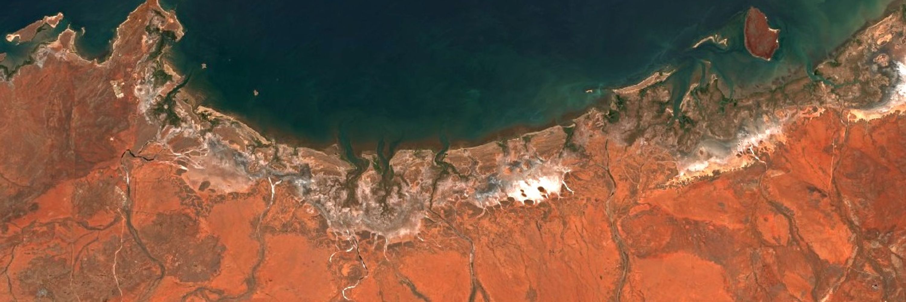
De Hoop Vlei (De Hoop Nature Reserve), #SouthAfrica
White sand dunes eventually blocked the Sout River from reaching the ocean and formed a coastal lagoon (vlei). Its salinity and physical water levels can vary greatly over time. www.southafrica.net/gl/en/travel...
maps.app.goo.gl/XXuDPGfRee5Q...
White sand dunes eventually blocked the Sout River from reaching the ocean and formed a coastal lagoon (vlei). Its salinity and physical water levels can vary greatly over time. www.southafrica.net/gl/en/travel...
maps.app.goo.gl/XXuDPGfRee5Q...

De Hoop Vlei; De Hoop Nature Reserve; Bredasdorp; Western Cape; Indian Ocean; 260 bird species; dunes; gorges; whale-watching (GL)
De Hoop Vlei near Bredasdorp has 260 species of birds and 1 500 species of plant to delight visitors – plus stunning scenery and whale-watching in Western Cape’s De Hoop Nature Reserve.
www.southafrica.net
November 18, 2024 at 3:58 AM
De Hoop Vlei (De Hoop Nature Reserve), #SouthAfrica
White sand dunes eventually blocked the Sout River from reaching the ocean and formed a coastal lagoon (vlei). Its salinity and physical water levels can vary greatly over time. www.southafrica.net/gl/en/travel...
maps.app.goo.gl/XXuDPGfRee5Q...
White sand dunes eventually blocked the Sout River from reaching the ocean and formed a coastal lagoon (vlei). Its salinity and physical water levels can vary greatly over time. www.southafrica.net/gl/en/travel...
maps.app.goo.gl/XXuDPGfRee5Q...
The village is only accessible by boat and was once home to the Taushiro tribe. In 2017, the New York Times published the tragic story of these people and their last native speaker, Amadeo García García. www.nytimes.com/2017/12/26/w...

Thousands Once Spoke His Language in the Amazon. Now, He’s the Only One. (Published 2017)
The Taushiro tribe vanished into the jungles of the Amazon basin in Peru generations ago. Amadeo García García is now the last native speaker of their language.
www.nytimes.com
November 16, 2024 at 2:07 AM
The village is only accessible by boat and was once home to the Taushiro tribe. In 2017, the New York Times published the tragic story of these people and their last native speaker, Amadeo García García. www.nytimes.com/2017/12/26/w...
Intuto, #Peru: the Tigre River passes through the Amazon's Napo Moist Forests (en.wikipedia.org/wiki/Napo_mo...), home to jaguars, pink river dolphins, and indigenous cultures.
Flowing waters are continuously carving a new river path, leaving behind these many distinctly U-shaped oxbow lakes.
Flowing waters are continuously carving a new river path, leaving behind these many distinctly U-shaped oxbow lakes.

Napo moist forests - Wikipedia
en.wikipedia.org
November 16, 2024 at 1:45 AM
Intuto, #Peru: the Tigre River passes through the Amazon's Napo Moist Forests (en.wikipedia.org/wiki/Napo_mo...), home to jaguars, pink river dolphins, and indigenous cultures.
Flowing waters are continuously carving a new river path, leaving behind these many distinctly U-shaped oxbow lakes.
Flowing waters are continuously carving a new river path, leaving behind these many distinctly U-shaped oxbow lakes.