


Tim Collins
@timcdc.bsky.social
NWS/OPC Marine Meteorologist, always sleepy.
my fellow excessive sweaters, rejoice!! the first comfortable air mass on the horizon since july 4, and maybe the second time we've seen dew points below 60 in about a month. 😍
July 20, 2025 at 3:16 AM
my fellow excessive sweaters, rejoice!! the first comfortable air mass on the horizon since july 4, and maybe the second time we've seen dew points below 60 in about a month. 😍
lol CB Bucknor behind the plate, not even asking for help down the line. good freakin grief, man.

April 24, 2025 at 12:03 AM
lol CB Bucknor behind the plate, not even asking for help down the line. good freakin grief, man.
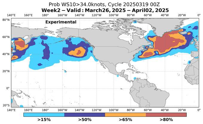
📣 Useful new marine forecasting tool from OPC released today! ocean.weather.gov/week2/
March 19, 2025 at 11:41 PM
📣 Useful new marine forecasting tool from OPC released today! ocean.weather.gov/week2/
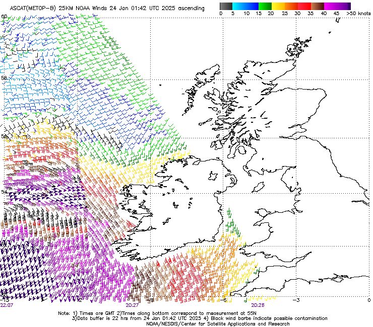
Advanced Scatterometer (ASCAT) overpasses between 2123z-2207z this evening -- widespread storm and hurricane-force winds returned with #StormEowyn, with some retrievals up to 80kt 🌬️
January 24, 2025 at 2:18 AM
Advanced Scatterometer (ASCAT) overpasses between 2123z-2207z this evening -- widespread storm and hurricane-force winds returned with #StormEowyn, with some retrievals up to 80kt 🌬️
Snow squall and thundersnow here in the Groveton area of Alexandria, VA!! 😍
January 3, 2025 at 8:51 PM
Snow squall and thundersnow here in the Groveton area of Alexandria, VA!! 😍
In a continuation of a weeks-long parade of hurricane-force lows across the N Pacific... owing to dynamic fetch and 90 kt winds, the low now crossing the dateline along 40N set to be a prolific wave producer, with 60 ft significant wave heights now in the forecast. Incredible stuff.
December 20, 2024 at 5:44 PM
In a continuation of a weeks-long parade of hurricane-force lows across the N Pacific... owing to dynamic fetch and 90 kt winds, the low now crossing the dateline along 40N set to be a prolific wave producer, with 60 ft significant wave heights now in the forecast. Incredible stuff.
Just incredible views from Himawari-9 ProxyVis. From the NFDHSFEPI: ".LOW 45N167E 942 MB MOVING NE 25 KT. WITHIN 240 NM S AND SW QUADRANTS WINDS 75 TO 100 KT. SEAS 38 TO 52 FT." Should get ASCAT overpasses soon, but those saturate around 85 kt. We shall see...
December 14, 2024 at 10:59 PM
Just incredible views from Himawari-9 ProxyVis. From the NFDHSFEPI: ".LOW 45N167E 942 MB MOVING NE 25 KT. WITHIN 240 NM S AND SW QUADRANTS WINDS 75 TO 100 KT. SEAS 38 TO 52 FT." Should get ASCAT overpasses soon, but those saturate around 85 kt. We shall see...
100 kt (115 mph) sustained winds, 16 meters (>50 ft) significant wave heights in the west/central Pacific. an outstanding forecast 5+ days out. marine traffic avoidance pretty apparent. some of the holiday season gifts inbound for the west coast will be rockin and rollin.


December 14, 2024 at 12:57 PM
100 kt (115 mph) sustained winds, 16 meters (>50 ft) significant wave heights in the west/central Pacific. an outstanding forecast 5+ days out. marine traffic avoidance pretty apparent. some of the holiday season gifts inbound for the west coast will be rockin and rollin.
as forecast: explosive cyclogenesis now underway across the eastern pacific with 68 mb pressure falls forecast over the next 24 hours (1011 mb to 943 mb)! satellite imagery throughout the day will be something to behold 🌊🌊


November 19, 2024 at 5:04 AM
as forecast: explosive cyclogenesis now underway across the eastern pacific with 68 mb pressure falls forecast over the next 24 hours (1011 mb to 943 mb)! satellite imagery throughout the day will be something to behold 🌊🌊
Good catch, Dave! I certainly believe so
November 15, 2024 at 9:33 PM
Good catch, Dave! I certainly believe so
Beast of a low still intensifying offshore the Carolinas, displaying the tell-tale signs of a very potent system. Milky and hazy appearance near the sting jet / descending ccb likely sea spray, indicative of some serious winds in the S/SW quadrant. Loads of lightning, too! #MarineWx
November 15, 2024 at 6:21 PM
Beast of a low still intensifying offshore the Carolinas, displaying the tell-tale signs of a very potent system. Milky and hazy appearance near the sting jet / descending ccb likely sea spray, indicative of some serious winds in the S/SW quadrant. Loads of lightning, too! #MarineWx
sunrise over our potent little low developing off the NC coast this morning, buoy 41025 / diamond shoals already gusting to storm force 👀


November 15, 2024 at 1:16 PM
sunrise over our potent little low developing off the NC coast this morning, buoy 41025 / diamond shoals already gusting to storm force 👀
First trip to the aquarium! 😍 🐠🦈

November 11, 2024 at 6:11 PM
First trip to the aquarium! 😍 🐠🦈
rockin' and rollin' offshore, 50 kt winds and 25 ft seas 🌊- interestingly, energy sheds northeast from this system and helps amplify the big blow headed for the UK over the weekend

October 17, 2024 at 5:13 PM
rockin' and rollin' offshore, 50 kt winds and 25 ft seas 🌊- interestingly, energy sheds northeast from this system and helps amplify the big blow headed for the UK over the weekend
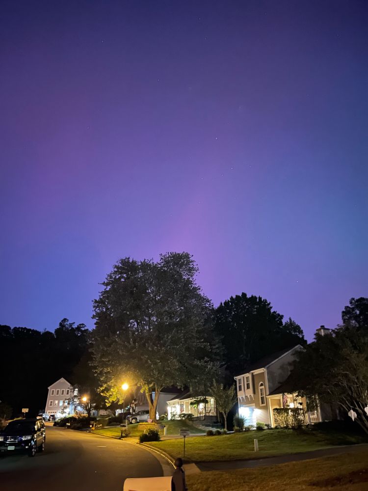
northern lights from Alexandria, VA! 🤩

October 10, 2024 at 11:42 PM
northern lights from Alexandria, VA! 🤩
Storm-force winds returned in the ASCAT overpasses this morning associated with the (very non-tropical looking) AL99 🌬️🌬️


September 6, 2024 at 4:41 PM
Storm-force winds returned in the ASCAT overpasses this morning associated with the (very non-tropical looking) AL99 🌬️🌬️
Decent shot Monday for daily record highs at DCA (100) and IAD (98); I hope Tuesday RMAXs (104) are out of reach. Brutal summer surge on the way regardless. 🥵 Cold front Wed night and the next air mass Thu/Fri will be glorious. Put in your leave requests now!


July 13, 2024 at 12:21 PM
Decent shot Monday for daily record highs at DCA (100) and IAD (98); I hope Tuesday RMAXs (104) are out of reach. Brutal summer surge on the way regardless. 🥵 Cold front Wed night and the next air mass Thu/Fri will be glorious. Put in your leave requests now!


Winds are rippin', gusts to near 70 kt or higher at Eastport, Mt. Desert Rock, and Matinicus Rock within the past hour 👀


December 19, 2023 at 1:03 AM
Winds are rippin', gusts to near 70 kt or higher at Eastport, Mt. Desert Rock, and Matinicus Rock within the past hour 👀
939 mb, hurricane force low across the far northwest pacific and bering sea. what a sight.

November 20, 2023 at 1:25 AM
939 mb, hurricane force low across the far northwest pacific and bering sea. what a sight.