


Tomasral
@tomasral.es
Geographer and cartographer @geonalon.com 🗺, train nerd 🚂, rural living 👨🌾, amateur weightlifter🏋️♂️and language learner 🗣️.
Triangulum Galaxy. 7:30 min of exposure. My first deep sky astrophoto.

October 19, 2025 at 4:35 PM
Triangulum Galaxy. 7:30 min of exposure. My first deep sky astrophoto.

Happy New Year!!!!
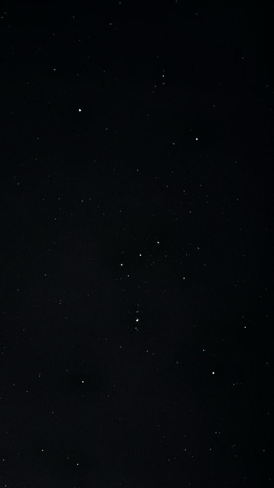
Orion. New Year Sky.
Orion. New Year Sky.
January 1, 2025 at 8:08 AM
Happy New Year!!!!
Orion. New Year Sky.
Orion. New Year Sky.
December 1, 2024 at 8:59 PM
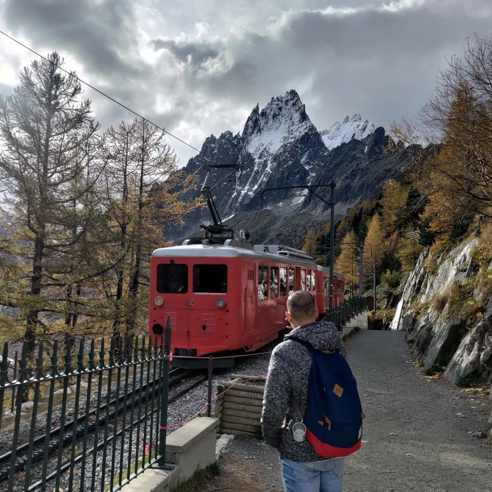
Day 29: Overture. Chemin de fer-musée Blonay-Chamby. Data: Overture Maps and SwissTopo
#30DayMapChallenge #Map #GIS #QGIS
#30DayMapChallenge #Map #GIS #QGIS

November 29, 2024 at 10:21 AM
Day 29: Overture. Chemin de fer-musée Blonay-Chamby. Data: Overture Maps and SwissTopo
#30DayMapChallenge #Map #GIS #QGIS
#30DayMapChallenge #Map #GIS #QGIS
Day 28: The Blue Planet. Changes in average surface ocean pH between 2000-2010 and 2010-2020 decades. Thanks to @carmenblancof.bsky.social cial for helping me with this topic. Data: Bio-ORACLE.
#30DayMapChallenge #Map #GIS #QGIS
#30DayMapChallenge #Map #GIS #QGIS

November 28, 2024 at 12:44 PM
Day 28: The Blue Planet. Changes in average surface ocean pH between 2000-2010 and 2010-2020 decades. Thanks to @carmenblancof.bsky.social cial for helping me with this topic. Data: Bio-ORACLE.
#30DayMapChallenge #Map #GIS #QGIS
#30DayMapChallenge #Map #GIS #QGIS
Day 27: Micromapping. A Farm mapped using drone imagery and Warren Davison styles (www.esri.com/about/newsro...)
#30DayMapChallenge #Map #GIS #ArcGISPro
#30DayMapChallenge #Map #GIS #ArcGISPro

November 27, 2024 at 9:09 AM
Day 27: Micromapping. A Farm mapped using drone imagery and Warren Davison styles (www.esri.com/about/newsro...)
#30DayMapChallenge #Map #GIS #ArcGISPro
#30DayMapChallenge #Map #GIS #ArcGISPro

Day 26: Projections. Spain Users' Main Errors Projecting Geographical Data
#30DayMapChallenge #Map #GIS #QGIS
#30DayMapChallenge #Map #GIS #QGIS

November 26, 2024 at 9:24 AM
Day 26: Projections. Spain Users' Main Errors Projecting Geographical Data
#30DayMapChallenge #Map #GIS #QGIS
#30DayMapChallenge #Map #GIS #QGIS
Day 25: Heat. Volcanoes and glaciated areas in Iceland. Data: OSM and Natural Earth
#30DayMapChallenge #Map #GIS #QGIS
#30DayMapChallenge #Map #GIS #QGIS

November 25, 2024 at 9:07 AM
Day 25: Heat. Volcanoes and glaciated areas in Iceland. Data: OSM and Natural Earth
#30DayMapChallenge #Map #GIS #QGIS
#30DayMapChallenge #Map #GIS #QGIS

November 24, 2024 at 12:59 PM

November 24, 2024 at 10:48 AM

November 22, 2024 at 10:05 AM
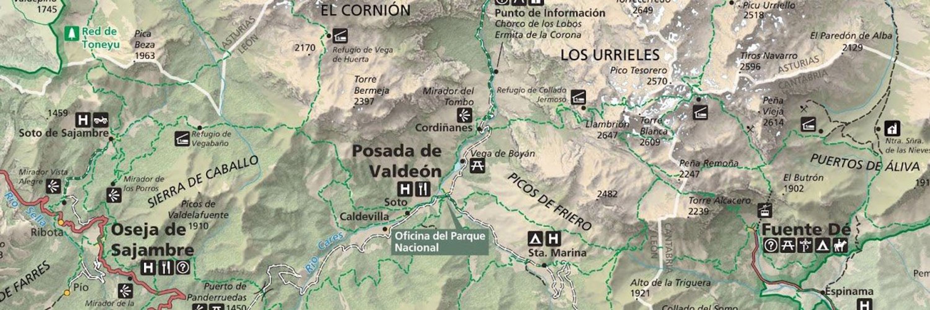
Day 21: Conflict. Disputed area between Somiedo and Cabrillanes. Data: IGN
#30DayMapChallenge #Map #GIS #QGIS
#30DayMapChallenge #Map #GIS #QGIS

November 21, 2024 at 11:40 AM
Day 21: Conflict. Disputed area between Somiedo and Cabrillanes. Data: IGN
#30DayMapChallenge #Map #GIS #QGIS
#30DayMapChallenge #Map #GIS #QGIS
Day 20: OSM. Distance from residential buildings to grocery stores. Data: @openstreetmap.bsky.social
#30DayMapChallenge #Map #GIS #QGIS
#30DayMapChallenge #Map #GIS #QGIS

November 20, 2024 at 10:17 AM
Day 20: OSM. Distance from residential buildings to grocery stores. Data: @openstreetmap.bsky.social
#30DayMapChallenge #Map #GIS #QGIS
#30DayMapChallenge #Map #GIS #QGIS
Day 19: Typography. Pravia Town Map. Data:
@openstreetmap.bsky.social
#30DayMapChallenge #Map #GIS #QGIS
@openstreetmap.bsky.social
#30DayMapChallenge #Map #GIS #QGIS

November 19, 2024 at 1:23 PM
Day 19: Typography. Pravia Town Map. Data:
@openstreetmap.bsky.social
#30DayMapChallenge #Map #GIS #QGIS
@openstreetmap.bsky.social
#30DayMapChallenge #Map #GIS #QGIS
Day 18: 3D. 3D printed LiDAR generated DSM. Data: IGN. Printed by @pablomr_23
#30DayMapChallenge #Map #GIS
#30DayMapChallenge #Map #GIS

November 18, 2024 at 9:43 AM
Day 18: 3D. 3D printed LiDAR generated DSM. Data: IGN. Printed by @pablomr_23
#30DayMapChallenge #Map #GIS
#30DayMapChallenge #Map #GIS
Day 17: A Collaborative Map. Made with my sister Clararal on Google Colab with Python and Geopandas. Civil Parish Population Density (2023). Data:
@sadei.bsky.social
#30DayMapChallenge #Map #GIS #Python #Geopandas
@sadei.bsky.social
#30DayMapChallenge #Map #GIS #Python #Geopandas

November 17, 2024 at 10:42 PM
Day 17: A Collaborative Map. Made with my sister Clararal on Google Colab with Python and Geopandas. Civil Parish Population Density (2023). Data:
@sadei.bsky.social
#30DayMapChallenge #Map #GIS #Python #Geopandas
@sadei.bsky.social
#30DayMapChallenge #Map #GIS #Python #Geopandas
Day 16: Choropleths. Old Age Index according to D. Noin and P.J. Thumerelle in Oviedo/Uviéu Districts (2023). Data: @sadei.bsky.social
#30DayMapChallenge #Map #GIS #QGIS
#30DayMapChallenge #Map #GIS #QGIS

November 16, 2024 at 1:59 PM
Day 16: Choropleths. Old Age Index according to D. Noin and P.J. Thumerelle in Oviedo/Uviéu Districts (2023). Data: @sadei.bsky.social
#30DayMapChallenge #Map #GIS #QGIS
#30DayMapChallenge #Map #GIS #QGIS

November 15, 2024 at 11:09 PM
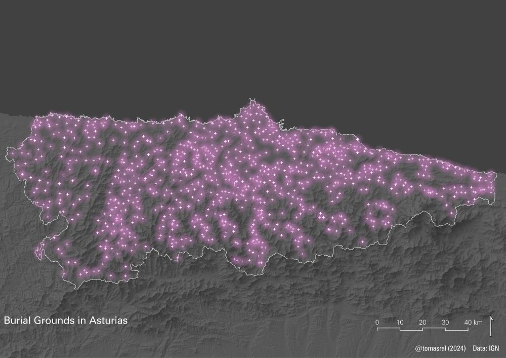
Day 14: A World Map. Certified International Dark Sky Places and Light Pollution @IDADarkSky. Data: see below.
#30DayMapChallenge #Map #GIS #QGIS
#30DayMapChallenge #Map #GIS #QGIS

November 15, 2024 at 11:09 PM
Day 14: A World Map. Certified International Dark Sky Places and Light Pollution @IDADarkSky. Data: see below.
#30DayMapChallenge #Map #GIS #QGIS
#30DayMapChallenge #Map #GIS #QGIS
Day 12: A New Tool: R. Population in Asturias (2023) Data:
@sadeiAsturias
#30DayMapChallenge #Map #GIS #R
@sadeiAsturias
#30DayMapChallenge #Map #GIS #R

November 15, 2024 at 11:09 PM
Day 12: A New Tool: R. Population in Asturias (2023) Data:
@sadeiAsturias
#30DayMapChallenge #Map #GIS #R
@sadeiAsturias
#30DayMapChallenge #Map #GIS #R
Day 11: Time and Space. Avilés 1956-2023: Industralization, deindustralization and urban growth. Data: PNOA
@IGNSpain
#30DayMapChallenge #Map #GIS #QGIS
@IGNSpain
#30DayMapChallenge #Map #GIS #QGIS

November 15, 2024 at 11:09 PM
Day 11: Time and Space. Avilés 1956-2023: Industralization, deindustralization and urban growth. Data: PNOA
@IGNSpain
#30DayMapChallenge #Map #GIS #QGIS
@IGNSpain
#30DayMapChallenge #Map #GIS #QGIS

November 15, 2024 at 11:09 PM
Day 10: Pen and Paper. Patones Geomorphological Sketch. A map I did in College #30DayMapChallenge #Map #GIS

November 15, 2024 at 11:09 PM
Day 10: Pen and Paper. Patones Geomorphological Sketch. A map I did in College #30DayMapChallenge #Map #GIS