


Tommaso Orusa
@tomorusa.bsky.social
MD Forestry & Environmental Sciences | PhD in Earth Observation from space Remote Sensing & GIS | R&D @ INVA spa | Researcher @ IZSAM 🌍🛰🌲🌱🦊
🌍✨ Ready to push the boundaries of GeoAI? Join the Special Issue @Drones_MDPI
"GeoAI for UAVs and Earth Observation: Methods, Applications and Possible Integration in Drones."
📢 👉 Submission details: mdpi.com/journal/drones…#GeoAIA#UAVA#EarthObservationon
"GeoAI for UAVs and Earth Observation: Methods, Applications and Possible Integration in Drones."
📢 👉 Submission details: mdpi.com/journal/drones…#GeoAIA#UAVA#EarthObservationon
https://mdpi.com/journal/drones…
December 9, 2025 at 11:19 PM
🌍✨ Ready to push the boundaries of GeoAI? Join the Special Issue @Drones_MDPI
"GeoAI for UAVs and Earth Observation: Methods, Applications and Possible Integration in Drones."
📢 👉 Submission details: mdpi.com/journal/drones…#GeoAIA#UAVA#EarthObservationon
"GeoAI for UAVs and Earth Observation: Methods, Applications and Possible Integration in Drones."
📢 👉 Submission details: mdpi.com/journal/drones…#GeoAIA#UAVA#EarthObservationon
Still online @Fire_MDPI our Special Issue on
Integrating AI and Remote Sensing for Monitoring and Mapping Fire Impacts on Agroforestry and Wildlife Systems 🔥🌿🛰️🦉
👉 Submit here: mdpi.com/journal/fire/s…#Wildfirer#RemoteSensingn#AIA#Agroforestryr#Wildlifefe
Integrating AI and Remote Sensing for Monitoring and Mapping Fire Impacts on Agroforestry and Wildlife Systems 🔥🌿🛰️🦉
👉 Submit here: mdpi.com/journal/fire/s…#Wildfirer#RemoteSensingn#AIA#Agroforestryr#Wildlifefe
https://mdpi.com/journal/fire/s…
December 9, 2025 at 11:18 PM
Still online @Fire_MDPI our Special Issue on
Integrating AI and Remote Sensing for Monitoring and Mapping Fire Impacts on Agroforestry and Wildlife Systems 🔥🌿🛰️🦉
👉 Submit here: mdpi.com/journal/fire/s…#Wildfirer#RemoteSensingn#AIA#Agroforestryr#Wildlifefe
Integrating AI and Remote Sensing for Monitoring and Mapping Fire Impacts on Agroforestry and Wildlife Systems 🔥🌿🛰️🦉
👉 Submit here: mdpi.com/journal/fire/s…#Wildfirer#RemoteSensingn#AIA#Agroforestryr#Wildlifefe
📢 Call for Papers! Contribute to the @Animals_MDPI Special Issue: Multi-Sensor Remote Sensing and Ecological Models for Bird and Wildlife Conservation 🐦🌍
🔗 Submit here: mdpi.com/journal/animal…#WildlifeConservationo#RemoteSensingn#Ecologyg#Birdsds
🔗 Submit here: mdpi.com/journal/animal…#WildlifeConservationo#RemoteSensingn#Ecologyg#Birdsds
https://mdpi.com/journal/animal…
December 9, 2025 at 11:17 PM
📢 Call for Papers! Contribute to the @Animals_MDPI Special Issue: Multi-Sensor Remote Sensing and Ecological Models for Bird and Wildlife Conservation 🐦🌍
🔗 Submit here: mdpi.com/journal/animal…#WildlifeConservationo#RemoteSensingn#Ecologyg#Birdsds
🔗 Submit here: mdpi.com/journal/animal…#WildlifeConservationo#RemoteSensingn#Ecologyg#Birdsds
👏 Congrats @giswqs.bsky.social for the amazing work! 🚀 New SamGeo QGIS plugin powered by SAM 3 makes satellite image segmentation easy—no code needed. 🌍 Calling on the scientific & GIS community to explore!
👉 Plugin here: github.com/opengeos/qgis-…
💻 Full video tutorial: youtu.be/oPZc7BvDsHE
👉 Plugin here: github.com/opengeos/qgis-…
💻 Full video tutorial: youtu.be/oPZc7BvDsHE
https://github.com/opengeos/qgis-…
December 9, 2025 at 9:21 PM
👏 Congrats @giswqs.bsky.social for the amazing work! 🚀 New SamGeo QGIS plugin powered by SAM 3 makes satellite image segmentation easy—no code needed. 🌍 Calling on the scientific & GIS community to explore!
👉 Plugin here: github.com/opengeos/qgis-…
💻 Full video tutorial: youtu.be/oPZc7BvDsHE
👉 Plugin here: github.com/opengeos/qgis-…
💻 Full video tutorial: youtu.be/oPZc7BvDsHE

🌍🛰️ Earth looking up like:
“Who put all this stuff in my orbit?!”
Track every satellite (and space junk!) in real-time with Satcat 🚀
👉 satcat.com
If it’s flying above us, this site probably knows about it.
#Satracking #RemoteSensing
“Who put all this stuff in my orbit?!”
Track every satellite (and space junk!) in real-time with Satcat 🚀
👉 satcat.com
If it’s flying above us, this site probably knows about it.
#Satracking #RemoteSensing
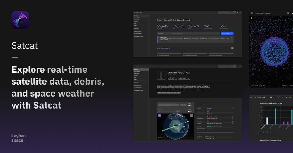
Satcat | Spaceflight Intelligence Exchange
Explore real-time data on satellites, space debris, and space weather in Satcat, the Spaceflight Intelligence Exchange by Kayhan Space
satcat.com
October 1, 2025 at 9:05 PM
🌍🛰️ Earth looking up like:
“Who put all this stuff in my orbit?!”
Track every satellite (and space junk!) in real-time with Satcat 🚀
👉 satcat.com
If it’s flying above us, this site probably knows about it.
#Satracking #RemoteSensing
“Who put all this stuff in my orbit?!”
Track every satellite (and space junk!) in real-time with Satcat 🚀
👉 satcat.com
If it’s flying above us, this site probably knows about it.
#Satracking #RemoteSensing
Il 3-4 ottobre 2025 con #AnnalisaViani e #IZSPLV #CERMAS interverremo al Master in Amministrazione e gestione della fauna selvatica dell'Università #CaFoscari #Venezia vi ricordo che sono già disponibili info per il prossimo anno www.unive.it/maste-fauna e novità sulle borse di studio a.a. 25/26!

September 26, 2025 at 10:20 AM
Il 3-4 ottobre 2025 con #AnnalisaViani e #IZSPLV #CERMAS interverremo al Master in Amministrazione e gestione della fauna selvatica dell'Università #CaFoscari #Venezia vi ricordo che sono già disponibili info per il prossimo anno www.unive.it/maste-fauna e novità sulle borse di studio a.a. 25/26!
🚨 New Special Issue on Fire MDPI
Integrating AI and Remote Sensing for Monitoring and Mapping Fire Impacts on Agroforestry and Wildlife Systems 🔥🌿🛰️🦉
👉 Submit here: www.mdpi.com/journal/fire... #Wildfire #RemoteSensing #AI #Agroforestry #Wildlife #OneHealth
Integrating AI and Remote Sensing for Monitoring and Mapping Fire Impacts on Agroforestry and Wildlife Systems 🔥🌿🛰️🦉
👉 Submit here: www.mdpi.com/journal/fire... #Wildfire #RemoteSensing #AI #Agroforestry #Wildlife #OneHealth
www.mdpi.com
September 16, 2025 at 5:40 PM
🚨 New Special Issue on Fire MDPI
Integrating AI and Remote Sensing for Monitoring and Mapping Fire Impacts on Agroforestry and Wildlife Systems 🔥🌿🛰️🦉
👉 Submit here: www.mdpi.com/journal/fire... #Wildfire #RemoteSensing #AI #Agroforestry #Wildlife #OneHealth
Integrating AI and Remote Sensing for Monitoring and Mapping Fire Impacts on Agroforestry and Wildlife Systems 🔥🌿🛰️🦉
👉 Submit here: www.mdpi.com/journal/fire... #Wildfire #RemoteSensing #AI #Agroforestry #Wildlife #OneHealth
