


Vivid Weather
@vividweather.bsky.social
Vivid Weather - Weather made simple.
https://discord.gg/fH24ruMbhj We have a community server with up to 600 members, all of which have an avid interest in tracking! Come join us!
https://discord.gg/fH24ruMbhj We have a community server with up to 600 members, all of which have an avid interest in tracking! Come join us!
Pinned

Join the Vivid Weather Discord Server!
Check out the Vivid Weather community on Discord – hang out with 644 other members and enjoy free voice and text chat.
discord.gg
discord.gg/fH24ruMbhj We have a community server with up to 600 members, all of which have an avid interest in tracking! Come join us!
A new storms brews in the Western Pacific as JMA & PAGASA designates a tropical depression that is expected to enter their PAR anytime soon. It is forecasted to be a moderate tropical storm before emerging in the South China Sea. Next name = #BasyangPH / #Penha


February 3, 2026 at 11:01 AM
A new storms brews in the Western Pacific as JMA & PAGASA designates a tropical depression that is expected to enter their PAR anytime soon. It is forecasted to be a moderate tropical storm before emerging in the South China Sea. Next name = #BasyangPH / #Penha
Effusive eruption at #MayonVolcano continues, generating incandescent lava flows, pyroclastic density currents (PDC) or “uson” and rockfall in the Mi-isi, Bonga and Basud Gullies on 27 January 2026. Alert Level 3 prevails over Mayon and entry into the 6-km Permanent Danger Zone must be prohibited.

January 27, 2026 at 1:17 PM
Effusive eruption at #MayonVolcano continues, generating incandescent lava flows, pyroclastic density currents (PDC) or “uson” and rockfall in the Mi-isi, Bonga and Basud Gullies on 27 January 2026. Alert Level 3 prevails over Mayon and entry into the 6-km Permanent Danger Zone must be prohibited.
A major winter storm, along with an arctic outbreak, are expected to bring impacts to much of the eastern ⅔ of the US. With this, widespread swaths of 6+ inches of snow are expected from Oklahoma into the Northeast.

January 23, 2026 at 2:47 AM
A major winter storm, along with an arctic outbreak, are expected to bring impacts to much of the eastern ⅔ of the US. With this, widespread swaths of 6+ inches of snow are expected from Oklahoma into the Northeast.

The JTWC has recently issued a TCFA for #91S or #16U (Left and center image). It will continue its southeastward movement and impact Northwestern Australia by early weekend.
Meanwhile, Invest #90P (17U) remains as another potential threat to New Caledonia. (right image)
(JTWC, JMA HIM-9)
Meanwhile, Invest #90P (17U) remains as another potential threat to New Caledonia. (right image)
(JTWC, JMA HIM-9)


January 22, 2026 at 5:00 AM

Tropical Cyclone #16P continues to bring heavy rainfall and strong winds to New Caledonia. All are advised to continue monitoring updates on the local weather service. It is unlikely to get named in the next few hours.

January 21, 2026 at 11:03 PM
Tropical Cyclone #16P continues to bring heavy rainfall and strong winds to New Caledonia. All are advised to continue monitoring updates on the local weather service. It is unlikely to get named in the next few hours.
Subtropical Depression #94P marked by the JTWC is currently bringing moderate to heavy rainfall to the northern parts of New Zealand. All are advised to be cautious and continue monitoring updates from the local weather service.

January 21, 2026 at 8:13 AM
Subtropical Depression #94P marked by the JTWC is currently bringing moderate to heavy rainfall to the northern parts of New Zealand. All are advised to be cautious and continue monitoring updates from the local weather service.
Update for TS #Ewetse and #16P:
Ewetse has slightly weakened as it approaches Southern Madagascar and is expected to weaken further; 16P continues to threaten the western coast of New Caledonia.
All residents of the mentioned places are advised to stay alert and be vigilant at all times.
(JTWC)
Ewetse has slightly weakened as it approaches Southern Madagascar and is expected to weaken further; 16P continues to threaten the western coast of New Caledonia.
All residents of the mentioned places are advised to stay alert and be vigilant at all times.
(JTWC)


January 21, 2026 at 8:07 AM
The Joint Typhoon Warning Center has issued its first warning on TC #16P. The system is expected to pass in close proximity on the western coast of New Caledonia. Residents should be aware of intense rainfall and flooding.


January 21, 2026 at 3:22 AM
The Joint Typhoon Warning Center has issued its first warning on TC #16P. The system is expected to pass in close proximity on the western coast of New Caledonia. Residents should be aware of intense rainfall and flooding.

Tropical Storm #Ewetse has been named and is expected to make landfall in Southern Madagascar tomorrow. All residents should be cautious of heavy rainfall and flooding within the periphery of Ewetse.
(JTWC and CyclonicWX)
(JTWC and CyclonicWX)


January 21, 2026 at 12:31 AM
Tropical Storm #Ewetse has been named and is expected to make landfall in Southern Madagascar tomorrow. All residents should be cautious of heavy rainfall and flooding within the periphery of Ewetse.
(JTWC and CyclonicWX)
(JTWC and CyclonicWX)


STS #Dudzai and Invest #98S lingering on the Southwest Indian Ocean, with the former expected to begin its extratropical transition as it interacts with the polar jet, and the latter going eastward into southern Madagascar as it quickly consolidates over the next 24 hours. (JTWC)


January 20, 2026 at 12:03 PM

Bahagyang lumakas ang Bagyong Tino (Kalmaegi) bilang isang Severe Tropical Storm habang kumikilos pa-kanluran sa silangan ng Kabisayaan. Inaasahang lalakas pa ito bilang isang Typhoon bukas ng umaga o hapon.

November 2, 2025 at 10:17 AM
Bahagyang lumakas ang Bagyong Tino (Kalmaegi) bilang isang Severe Tropical Storm habang kumikilos pa-kanluran sa silangan ng Kabisayaan. Inaasahang lalakas pa ito bilang isang Typhoon bukas ng umaga o hapon.
Severe Tropical Storm #Kalmaegi (#TinoPH) continues to move West-northwestward and is expected to become a Typhoon by 2pm UTC+08:00 on the 3rd of November as it nears Southeastern Visayas.

November 2, 2025 at 10:09 AM
Severe Tropical Storm #Kalmaegi (#TinoPH) continues to move West-northwestward and is expected to become a Typhoon by 2pm UTC+08:00 on the 3rd of November as it nears Southeastern Visayas.
#23W (#MirasolPH) has made landfall earlier at 3:20AM at the Municipality of Casiguran, Aurora in the Philippines as a low-end official Tropical Storm by the JTWC. Meanwhile, another Tropical Depression recently designated by JMA aiming to be another potential threat in Northern Luzon and Taiwan.

September 17, 2025 at 2:05 AM
#23W (#MirasolPH) has made landfall earlier at 3:20AM at the Municipality of Casiguran, Aurora in the Philippines as a low-end official Tropical Storm by the JTWC. Meanwhile, another Tropical Depression recently designated by JMA aiming to be another potential threat in Northern Luzon and Taiwan.
The Storm Prediction Center has issued a slight risk for severe weather for parts of the northern and central Plains. A 5% chance for tornadoes has been issued for parts of North Dakota and South Dakota. Also, there's a 15% chance for large hail and damaging winds. #severewx

September 14, 2025 at 5:06 PM
The Storm Prediction Center has issued a slight risk for severe weather for parts of the northern and central Plains. A 5% chance for tornadoes has been issued for parts of North Dakota and South Dakota. Also, there's a 15% chance for large hail and damaging winds. #severewx
#22W is set to intensify into a #Typhoon per the #JTWC and #HKO. It is also likely to undergo rapid intensification in the next few hours. It is unofficially a Tropical Storm, and could become a Category 1 by tomorrow evening. Possible landfall on Guangdong on Monday morning.

September 6, 2025 at 8:48 AM
#Hurricane #Kiko is currently intensifying in the open Eastern Pacific. The current BT intensity is set at 90 kt and Kiko is expected to peak as a Category 3 in the coming days. Hawaii may want to watch out for downstream impacts in the coming week or two.


September 3, 2025 at 1:53 AM
#Hurricane #Kiko is currently intensifying in the open Eastern Pacific. The current BT intensity is set at 90 kt and Kiko is expected to peak as a Category 3 in the coming days. Hawaii may want to watch out for downstream impacts in the coming week or two.
Tropical Storm #Kiko has formed in the Eastern Pacific. As it moves west, it has potential to become a strong #hurricane. #NHC currently forecasts an 85 kt storm but some models have it achieve a stronger intensity. Hawaii should watch out for potential impacts down the line.


August 31, 2025 at 5:41 PM
Tropical Storm #Kiko has formed in the Eastern Pacific. As it moves west, it has potential to become a strong #hurricane. #NHC currently forecasts an 85 kt storm but some models have it achieve a stronger intensity. Hawaii should watch out for potential impacts down the line.
The North Atlantic is unusually quiet heading into early September. We currently only have one AOI that has a low chance to form in the next 7 days from the #NHC. Activity should pick up by mid month and we expect mid September through the early part of October to be fairly busy.


August 30, 2025 at 9:18 PM
The North Atlantic is unusually quiet heading into early September. We currently only have one AOI that has a low chance to form in the next 7 days from the #NHC. Activity should pick up by mid month and we expect mid September through the early part of October to be fairly busy.
#Fernand is on a downward trend now. Northernly shear is taking a toll on the system leaving the LLC exposed with convection displaced to the south. Conditions are not expected to improve for Fernand. The cyclone should become non-tropical in around 36 hours.
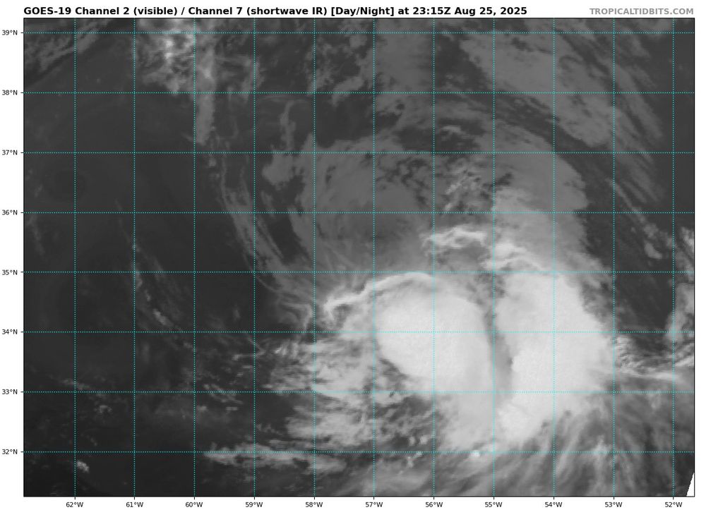

August 25, 2025 at 11:32 PM
#Fernand is on a downward trend now. Northernly shear is taking a toll on the system leaving the LLC exposed with convection displaced to the south. Conditions are not expected to improve for Fernand. The cyclone should become non-tropical in around 36 hours.