WB62
@wb62.bsky.social
830 followers 24 following 160 posts
Posts Media Videos Starter Packs
Pinned
wb62.bsky.social
Fun Fact: Did you know there are over 40 new GO Transit Stations proposed across the network? Once completed, the General Toronto & Hamilton Area will have over 110 GO Stations, and potentially up to 11 regional rail lines.
A map showing the potential future of the GO Transit regional rail network with all proposed stations and extensions.

This map is not affiliated with Metrolinx and/or any affiliated companies and does not act as a source or official confirmation for projects being undertaken by Metrolinx. Map made by WB62.
wb62.bsky.social
Fun Fact: Ever heard of the GO Transit Hamilton-Guelph Line? This line was proposed in 1989 by the Think Rail Group, as part of a larger proposal for transit in Ontario.

This line would've travelled from the City of Hamilton to Guelph, linking 3 cities together in the western half of the GTHA.
wb62.bsky.social
Fun Fact: Ever heard of the GO Transit Brantford-London Line? This line was proposed in 1989 by the Think Rail Group, as apart of a larger proposal for transit expansions in Ontario.

This line would have travelled from the City of Toronto to London, along Lake Ontario and through Brantford.
wb62.bsky.social
Fun Fact: Ever heard of the proposed GO Transit Lakeshore West Line extension to Leslie Lookout?

This extension was proposed in 2021 by the Toronto Region Board of Trade, in a business case outlining potential improvements and expansions to the GO Transit network

This extension was never built
wb62.bsky.social
The platforms between York Street and Bay Street will see massive changes in the future.

Going off multiple public sources, most platforms will be combined and widened, and at least 17 new staircases and elevators will be added to improve passenger flow and accessibility.
wb62.bsky.social
The tenth map in my series of Toronto Union Station maps is finished.

This layer focuses on the train platform level portion of Union Station between York Street and Bay Street:

• York, VIA, Bay, Bremner Concourse Entrances
• Bay West Teamway Entrances
• Platforms 3-28
wb62.bsky.social
The ninth map in my series of Toronto Union Station maps is finished.

This layer focuses on the train platform level portion of Union Station between Lower Simcoe Street and York Street:

• York Street Bridge Entrances
• York West Teamway Entrances
• Platforms 1A-28
wb62.bsky.social
Network status info screens for all regional rail, subway, and light rail lines is great to see!

As transit continues to improve in our region, people will take more complex trips across multiple modes, so an information hub like this is important
wb62.bsky.social
Additionally, the Barrie was to also be rerouted out of Union Station to instead terminate at the new underground station in the vicinity of Union.

Both lines being rerouted would have alleviated crowding and provided more capacity for other rail services at Union Station.
wb62.bsky.social
Fun Fact: Did you know in 2012 Metrolinx proposed a reroute of the GO Transit Georgetown Line?

The proposed reroute would have taken the Georgetown Line out of Union Station, instead terminating at a new underground station in the vicinity of Union.

This reroute never happened
wb62.bsky.social
3: Digital signage on all platforms could be reconfigured to show different information.

If the screen is outside where a short train will be stopping, the screen can show a flashing arrow to grab passengers attention and guide them towards the shorter train boarding area.
wb62.bsky.social
2: In 2024 Metrolinx launched new departure screens across the GO network, which included train lengths to show passengers how long their train would be.

This was removed from the Union Station screens due to confusion, this information could now return as it’s been over a year.
wb62.bsky.social
1b: If the boarding area signage pilot were to roll out network-wide, lining the boarding zone colors along the platforms directly behind the yellow line would further help passengers understand where trains of varying lengths stop.
wb62.bsky.social
1a: In 2021 Metrolinx started the boarding area pilot at 2 GO stations in Toronto.

This pilot added train length information on platforms and station maps.

Rolling this signage out network-wide would help guide passengers to the areas of a platform shorter trains stop at.
wb62.bsky.social
As GO Transit renovates stations and shifts to shorter trains, train length information becomes more important.

3 things Metrolinx can do:

• Expand the boarding area pilot network wide
• Add train length to the Union Station departure screens
• Add arrows to digital signage
wb62.bsky.social
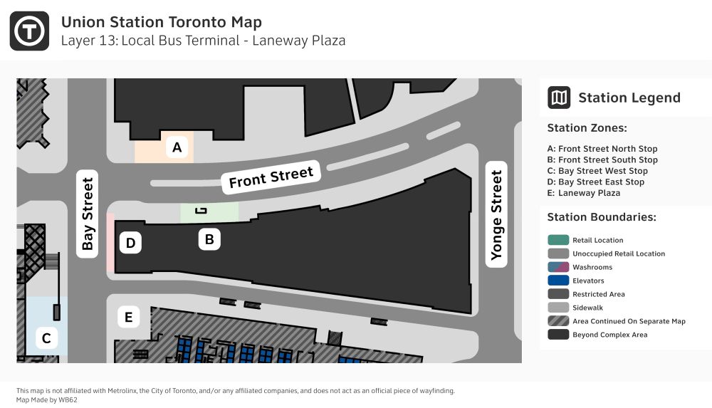
The eighth map in my series of Toronto Union Station maps is finished.

This layer focuses on the ground level portion of Union Station between Bay Street and Yonge Street:

• TTC local bus stops
• CIBC Square Laneway Plaza
wb62.bsky.social
More renderings:
wb62.bsky.social
Recently, more renderings of the new Exhibition GO Station/TTC Ontario Line terminal have been posted to UrbanToronto.

Exhibition will be one of the largest stations in the Toronto Area, and will be able to take on all current and future crowds headed to destinations at The Exhibition Grounds:
wb62.bsky.social
To recap:

I’m currently mapping the entire Union Station Toronto complex in a consistent style, something thats never been done before.

Because of the sheer size of Union, I’ve split each level into up to 3 different maps, for a total of 14 maps in total. 7 maps are completed:
wb62.bsky.social
The seventh map in my series of Toronto Union Station maps is finished.

This layer focuses on the ground level portion of Union Station west of York Street:

• York West Teamway
• Skywalk Lower Level
• Union Station Complex Entrances
• North-west Station Entrance
wb62.bsky.social
Yeah this was a layout shown in a blueprint for the Union Station Enhancement Project, which could’ve found on the City of Toronto AIC page a few years ago.

The platform layout was an official concept, but the numbers weren’t, that was my interpretation of what they could’ve been.
wb62.bsky.social
More tracks for increased Kitchener and UP Express Line service
wb62.bsky.social
Here are the Highway 401 tunnels, until the Etobicoke North platform is removed, these can’t be used:
wb62.bsky.social
There was always plans to relocate the station or permanently close it with no alternative built, Woodbine has been the planned relocation site for years now.

Woodbine will be big enough to support all local and express Kitchener Line trains, and all UP Express trains
wb62.bsky.social
Etobicoke North GO is currently in a very bad spot, as it’s in the way of the new Highway 401 tunnels that were constructed a few years ago, blocking a 4th track from being added.

The single-platform station can’t be expanded in its current location either, so most trains currently skip the stop.