Dr. Athena Masson
@weathergoddess.bsky.social
5.9K followers 330 following 460 posts
Meteorologist & Hurricane specialist. Creator of the Masson-Gough Hurricane Scale. UofT PhD Graduate. JU MBA. I collect degrees. Researcher and Professor 🎓Not a “Weather Girl”
Posts Media Videos Starter Packs
weathergoddess.bsky.social
We have Tropical Storm #Jerry in the central Atlantic gradually moving westward. Strengthening is expected over the next few days and likely could become a #hurricane. A Tropical Storm Watch has been issued for portions of the northern Leeward Islands. #wx
weathergoddess.bsky.social
An extensive forensic analysis of a deadly June tornado in North Dakota helped National Weather Service teams confirm the first EF-5 #tornado in the U.S. in more than 12 years. The tornado was one of 25 twisters that night. #wx
www.accuweather.com/en/severe-we...
The first EF5 tornado since 2013 has been confirmed in North Dakota
This tornado, which knocked a train off its tracks, ends the 12-year 'drought' of EF5 tornadoes since the Moore, Oklahoma storm in 2013.
www.accuweather.com
Reposted by Dr. Athena Masson
michaelrlowry.bsky.social
How about *only* hurricane pairings in the Atlantic and for the entire period of record (since 1851). What are the closest two hurricanes have ever been recorded? Humberto and Imelda right at the top. The nearest reliable contender was Easy and Fox back in 1951.
weathergoddess.bsky.social
#Imelda and #Humberto and the start of the Fujiwhara Effect. Humberto plays a large roll in saving the Southeast from a landfall as it tugs Imelda eastward. #Bermuda should monitor the progress of both storms as they begin to move north-northeast. #wx
weathergoddess.bsky.social
Humberto strengthens into a Category 5 #hurricane with max wind speeds near 160 mph & a barometric pressure of 925mb. #Humberto is the 2nd Cat 5 this season after #Erin. Since 1924, 44 storms have reached Cat 5 status. This is the 4th consecutive year in which a Cat 5 has formed.
weathergoddess.bsky.social
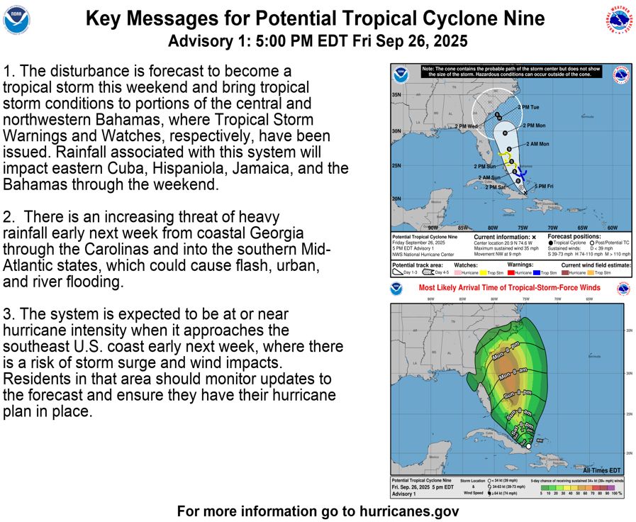
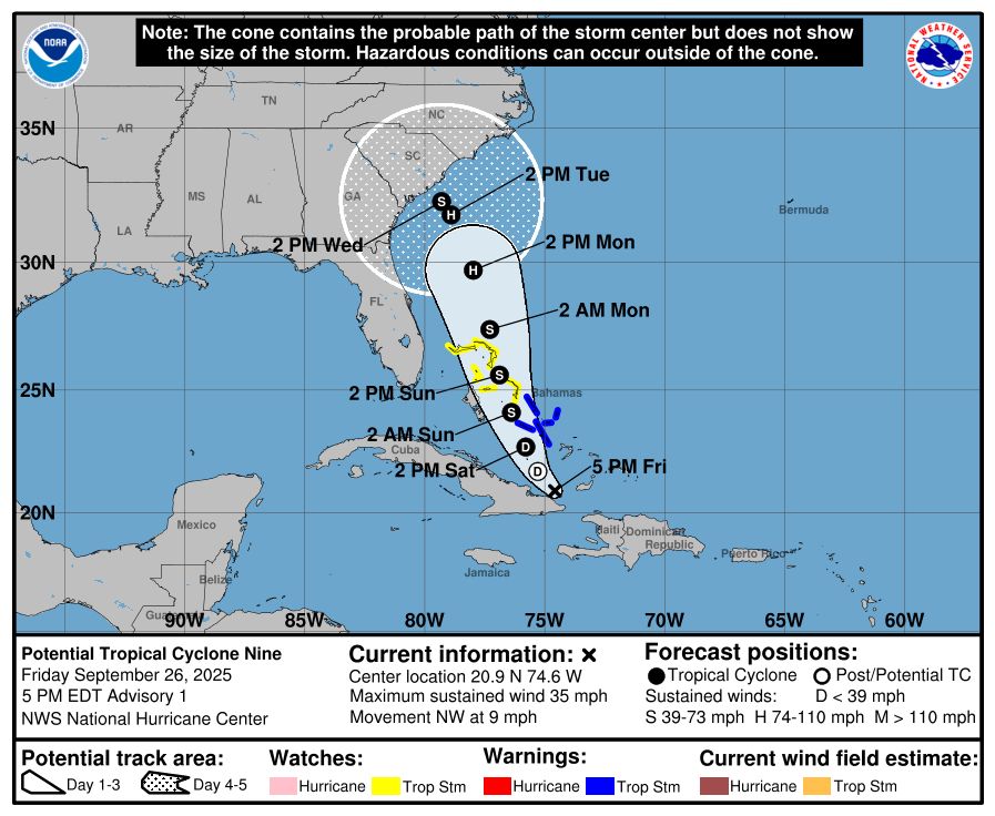
A Tropical Storm Watch has been issued for parts of #Florida from Palm Beach/Martin County Line northward to the Flagler/Volusia County Line. While the system is expected to stay just offshore coastal flooding, breezy winds, & showers will be likely this next week. #Imelda #wx
weathergoddess.bsky.social
Potential Tropical Cyclone Nine-likely to be Tropical Storm #Imelda. A tricky forecast as #Hurricane #Humberto is close by, which could influence Imelda’s path depending on proximity & strength. Big concern is if Imelda stalls offshore, producing flooding rains for the Southeast.
weathergoddess.bsky.social
Tropical Storm #Humberto has formed in the central Atlantic. Expected to strengthen over the next few days and possibly become a #hurricane over the weekend. No threat to land expected at this time but rip currents and strong swells will be likely along the Southeast coastlines.
weathergoddess.bsky.social
The tropics are coming alive again. #Gabrielle is now a Category 4 #hurricane with wind speeds near 140 mph. Expected to remain out to sea and move eastward towards the Azores. Two additional waves are moving westward across the central Atlantic. Development likely by end of week
weathergoddess.bsky.social
After a quiet few weeks we now have Tropical Storm #Gabrielle in the central Atlantic. Expected to gradually intensify over the next few days but no threat to the US at this time. #Bermuda should monitor the progression of this storm over the next several days. #wx
weathergoddess.bsky.social
After a lull in activity our attention shifts back to the Atlantic. A wave coming off Africa will travel westward over the next several days. The further south it tracks, the less amount of shear, which could favor formation. Currently a moderate (40%) chance for development. #wx
weathergoddess.bsky.social
Sept 10th is the statistic peak day of the Atlantic #Hurricane Season… and all is quiet. High tropical wind shear and frontal boundaries dipping more south are partly to blame this week. We still have a ways to go. Hurricane Season runs through Nov 30, another 81 days to go. #wx
weathergoddess.bsky.social
20 years since #HurricaneKatrina #Katrina became a large and powerful Cat 5 #hurricane in the Gulf before impacting #Mississippi and #Louisiana as a Cat 3 on August 29, 2005. Enormous destruction and significant loss of life. It is the costliest US hurricane on record. #wx
weathergoddess.bsky.social
Tropical Storm #Fernand Forms South-Southeast of Bermuda. Expected to Remain Over the Open Ocean. #wx
weathergoddess.bsky.social
Large #Erin is quickly moving out to sea. Far outer bands skirting parts of Atlantic Canada. Erin will continue to grow in size as it undergoes extratropical transition. Another wave to the south of Erin has a high chance of developing this weekend. Next name: #Fernand. #wx
weathergoddess.bsky.social
Eyewall replacement cycle with #Erin once more. New eye appearing on latest scan. A sign of strengthening. Erin will continue to grow in size as it moves northward & begin the process of extratropical transition. Coastal areas can expect strong surf & rip currents this week. #wx
weathergoddess.bsky.social
The tropical expressway has opened. Monitoring another wave coming off Africa. All eyes remain on #Erin still. Tropical Storm and Storm Surge Watches up for the North Carolina Outer Banks. Tropical storm conditions and coastal flooding are possible beginning late Wednesday. #wx
weathergoddess.bsky.social
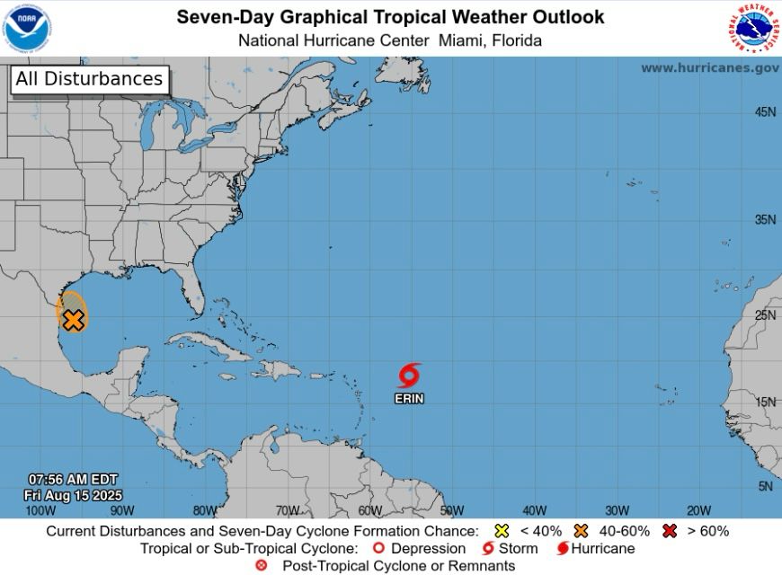
While #Erin is expected to stay out to sea we are already monitoring another wave that has a moderate chance of development over the next several days. This one will be something to monitor closely as it is expected to track further south compared to Erin. Next name: #Fernand. #wx
Reposted by Dr. Athena Masson
wxnb.bsky.social
Unbelievable footage from NOAA’s Hurricane Hunters inside the eye of Hurricane Erin.

Simply incredible.
Reposted by Dr. Athena Masson
drmetwatch.bsky.social
I mean…come on…

The moon through the top of Erin’s eye last night, taken by the #hurricanehunters
weathergoddess.bsky.social
#Hurricane #Erin is now a Category 5 storm with wind speeds near 160mph. Pressure at 917mb & continuing to lower. Since 1924 a total of 43 hurricanes have reached Category 5 status. The last Category 5 was Hurricane Milton (2024). #wx
weathergoddess.bsky.social
How is this “working myself up”? Nowhere am I informing that it is impacting or expected to impact an area. This information pertains to the current strength and situation of the storm.
weathergoddess.bsky.social
#Hurricane Hunters continue to monitor the progression of #Erin. Expected to strengthen over the weekend and has a chance of becoming a major hurricane (Cat 3+) as it moves north of the Caribbean Islands. Latest loop of convection showing an eye trying to form. 👁️ #wx
weathergoddess.bsky.social
#Erin becomes a #hurricane, the first of the 2025 season. On average the first hurricane of the season forms around August 11th. Parts of the northern Leeward Islands are under a Tropical Storm Watch. The core of Erin is expected to pass north of the islands this weekend. #wx
weathergoddess.bsky.social
We are entering the peak weeks of the Atlantic #Hurricane Season today. August 15 - October 15 is generally the most active time for tropical development, with the statistical peak being Sept. 10. Continuing to watch #Erin, which could become a hurricane later today. #wx