


Nahel Belgherze
@wxnb.bsky.social
Mainly focused on covering extreme weather events worldwide. Also interested in climate dynamics, geohazards and satellite remote sensing.
Also on X: x.com/wxnb_
Also on X: x.com/wxnb_
Grazalema, Spain, received over 2,000 mm (78 inches) of rain in just the last 20 days.
Over a year’s worth of rain — and it’s only early February. This is hydrologically absurd.
Over a year’s worth of rain — and it’s only early February. This is hydrologically absurd.

February 9, 2026 at 4:11 PM
Grazalema, Spain, received over 2,000 mm (78 inches) of rain in just the last 20 days.
Over a year’s worth of rain — and it’s only early February. This is hydrologically absurd.
Over a year’s worth of rain — and it’s only early February. This is hydrologically absurd.
Cuba 🇨🇺 has just recorded its lowest temperature on record this morning, with 0.0°C (32°F) at Indio Hatuey. This marks the first time in recorded history that the country has reached the freezing point.

February 3, 2026 at 7:35 PM
Cuba 🇨🇺 has just recorded its lowest temperature on record this morning, with 0.0°C (32°F) at Indio Hatuey. This marks the first time in recorded history that the country has reached the freezing point.
The hydrological situation across a large part of the Iberian Peninsula is alarming, to say the least, and conditions are set to worsen as several powerful atmospheric rivers are forecast; major flooding cannot be ruled out.

February 2, 2026 at 3:46 PM
The hydrological situation across a large part of the Iberian Peninsula is alarming, to say the least, and conditions are set to worsen as several powerful atmospheric rivers are forecast; major flooding cannot be ruled out.
Portugal and Spain are looking at tremendous precipitation from an onslaught of atmospheric rivers over the next 14-days. Flooding will certainly be a very real threat if these numbers materialize.

January 27, 2026 at 8:42 AM
Portugal and Spain are looking at tremendous precipitation from an onslaught of atmospheric rivers over the next 14-days. Flooding will certainly be a very real threat if these numbers materialize.
Storm Harry poses an extremely dangerous flooding threat to the central Mediterranean. The most extreme rainfall is forecast over eastern Sicily, especially the Province of Catania, where more than 500 mm of rain may fall in less than 48 hours.
January 19, 2026 at 12:03 PM
Storm Harry poses an extremely dangerous flooding threat to the central Mediterranean. The most extreme rainfall is forecast over eastern Sicily, especially the Province of Catania, where more than 500 mm of rain may fall in less than 48 hours.
Chilling satellite imagery emerging as #StormGoretti unleashes full fury upon parts of the UK and France. A 213 km/h wind gust was just reported at Gatteville-le-Phare (Manche) in northwestern France.

January 8, 2026 at 11:19 PM
Chilling satellite imagery emerging as #StormGoretti unleashes full fury upon parts of the UK and France. A 213 km/h wind gust was just reported at Gatteville-le-Phare (Manche) in northwestern France.
The latest high-resolution Met Office UKV model remains particularly aggressive regarding the impacts of Storm Goretti (named by Météo-France), with gusts of up to ~200 km/h modeled in the English Channel.

January 7, 2026 at 8:42 AM
The latest high-resolution Met Office UKV model remains particularly aggressive regarding the impacts of Storm Goretti (named by Météo-France), with gusts of up to ~200 km/h modeled in the English Channel.
Gorgeous satellite view of the fresh snow cover across northwestern France🇫🇷

January 6, 2026 at 12:47 PM
Gorgeous satellite view of the fresh snow cover across northwestern France🇫🇷
I can’t recall ever seeing a fog event footprint show up so clearly on a 30-day temperature anomaly map. Absolutely fascinating.
California’s Central Valley really sticks out amid widespread warmth across the West.
California’s Central Valley really sticks out amid widespread warmth across the West.

December 19, 2025 at 3:44 PM
I can’t recall ever seeing a fog event footprint show up so clearly on a 30-day temperature anomaly map. Absolutely fascinating.
California’s Central Valley really sticks out amid widespread warmth across the West.
California’s Central Valley really sticks out amid widespread warmth across the West.
It's hard to grasp the immense scale of the Indonesia floods until you see it from space.
And this is just a fraction of the full extent.
And this is just a fraction of the full extent.
December 3, 2025 at 10:47 AM
It's hard to grasp the immense scale of the Indonesia floods until you see it from space.
And this is just a fraction of the full extent.
And this is just a fraction of the full extent.
Reposted by Nahel Belgherze

Every Category 4 and 5 Atlantic hurricane since 2020, all together, in one group photo.
H/t to @ferragamowx.bsky.social for the inspiration.
H/t to @ferragamowx.bsky.social for the inspiration.

November 21, 2025 at 5:25 PM
Every Category 4 and 5 Atlantic hurricane since 2020, all together, in one group photo.
H/t to @ferragamowx.bsky.social for the inspiration.
H/t to @ferragamowx.bsky.social for the inspiration.
Reposted by Nahel Belgherze

Hurricane Melissa produced the fastest hurricane winds to be recorded by a dropsonde, verified by reviewing data at NSF NCAR! Hurricane Melissa’s 252 mph wind gust surpassed the previous record from Typhoon Megi over the Western Pacific in 2010, where a dropsonde measured wind gusts of 248 mph.

November 19, 2025 at 5:37 PM
Hurricane Melissa produced the fastest hurricane winds to be recorded by a dropsonde, verified by reviewing data at NSF NCAR! Hurricane Melissa’s 252 mph wind gust surpassed the previous record from Typhoon Megi over the Western Pacific in 2010, where a dropsonde measured wind gusts of 248 mph.
A big change of air mass is on the way.

November 13, 2025 at 7:29 PM
A big change of air mass is on the way.
This has to be unheard of. With an extraordinary peak flash rate of 699 flashes per minute just prior to landfall in Jamaica, Melissa probably set the record for the most prolific inner-core lightning outbreak ever recorded in an Atlantic hurricane.

November 6, 2025 at 5:40 PM
This has to be unheard of. With an extraordinary peak flash rate of 699 flashes per minute just prior to landfall in Jamaica, Melissa probably set the record for the most prolific inner-core lightning outbreak ever recorded in an Atlantic hurricane.
This is wild. Despite having fueled one of the strongest Atlantic hurricanes on record, the waters in the vicinity of where Melissa tracked remain sufficiently warm to support the formation of a major hurricane.

November 4, 2025 at 5:55 PM
This is wild. Despite having fueled one of the strongest Atlantic hurricanes on record, the waters in the vicinity of where Melissa tracked remain sufficiently warm to support the formation of a major hurricane.
NOAA aerial imagery is coming in. Hurricane Melissa literally turned western Jamaica from green to brown. Vegetation damage is immense — recovery will take years.
November 1, 2025 at 7:18 PM
NOAA aerial imagery is coming in. Hurricane Melissa literally turned western Jamaica from green to brown. Vegetation damage is immense — recovery will take years.
With 40 cm of snow left on the ground last Wednesday, Iceland’s capital, Reykjavík, officially experienced its biggest October snowstorm on record. This historic event shattered a 104-year-old record by 25 cm.

November 1, 2025 at 2:31 PM
With 40 cm of snow left on the ground last Wednesday, Iceland’s capital, Reykjavík, officially experienced its biggest October snowstorm on record. This historic event shattered a 104-year-old record by 25 cm.
The fact that we went nearly 20 years without a sub-900 mb Atlantic hurricane and now we’ve had two in just the last two seasons.
October 30, 2025 at 8:51 PM
The fact that we went nearly 20 years without a sub-900 mb Atlantic hurricane and now we’ve had two in just the last two seasons.
Reposted by Nahel Belgherze

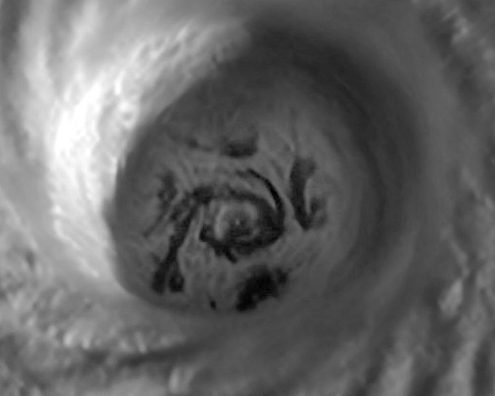
Alrighty, ready to see something really cool? (and maybe a little nauseating)
The evolution of Hurricane Melissa's mesovortices at peak strength.
The evolution of Hurricane Melissa's mesovortices at peak strength.
October 29, 2025 at 8:10 PM
Alrighty, ready to see something really cool? (and maybe a little nauseating)
The evolution of Hurricane Melissa's mesovortices at peak strength.
The evolution of Hurricane Melissa's mesovortices at peak strength.
NEW: Devastating imagery from Jamaica, before & after Category 5 Hurricane Melissa.
Black River — near total destruction.
Black River — near total destruction.
October 29, 2025 at 8:28 PM
NEW: Devastating imagery from Jamaica, before & after Category 5 Hurricane Melissa.
Black River — near total destruction.
Black River — near total destruction.
Hurricane Melissa’s historic journey to becoming one of the most intense tropical cyclones ever recorded on Earth.
A storm we won't forget anytime soon.
A storm we won't forget anytime soon.
October 29, 2025 at 1:49 PM
Hurricane Melissa’s historic journey to becoming one of the most intense tropical cyclones ever recorded on Earth.
A storm we won't forget anytime soon.
A storm we won't forget anytime soon.
Obvious wavenumber-5 mesovortex pattern within #Melissa’s eyewall earlier today — when the simulation matches reality. Just two decades ago, the very existence of mesovortices was still a matter of debate.

October 28, 2025 at 9:22 PM
Obvious wavenumber-5 mesovortex pattern within #Melissa’s eyewall earlier today — when the simulation matches reality. Just two decades ago, the very existence of mesovortices was still a matter of debate.
Hurricane Melissa has just broken the record for the driest eye ever observed in a tropical cyclone, with a temperature of -4.75°C.
This is nothing short of astronomical.
This is nothing short of astronomical.

October 27, 2025 at 5:49 PM
Hurricane Melissa has just broken the record for the driest eye ever observed in a tropical cyclone, with a temperature of -4.75°C.
This is nothing short of astronomical.
This is nothing short of astronomical.
The marine heatwave occurring across much of the East China Sea is one of the most extreme ever recorded in this part of the world. Over the past few days, it has reached “Beyond Extreme” Category 5 status — Completely uncharted territory.

October 22, 2025 at 1:49 PM
The marine heatwave occurring across much of the East China Sea is one of the most extreme ever recorded in this part of the world. Over the past few days, it has reached “Beyond Extreme” Category 5 status — Completely uncharted territory.
Just a nice calm look at 321 hours out from the GFS.

October 15, 2025 at 9:55 AM
Just a nice calm look at 321 hours out from the GFS.