Wisconet
@wisconet.bsky.social
760 followers 100 following 880 posts
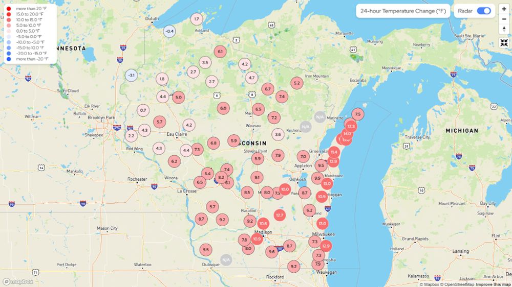
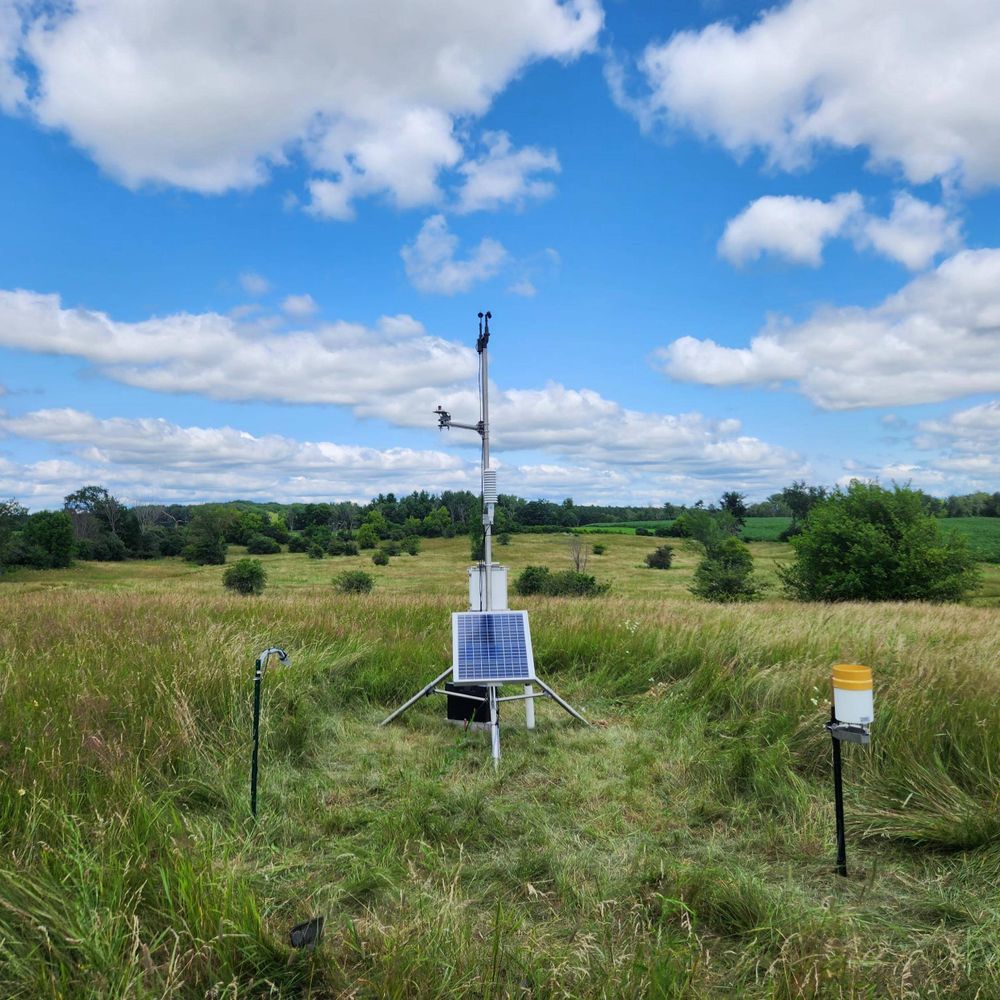
A network of 78 weather and soil monitoring stations in Wisconsin. We're growing with the support of the USDA Rural Partnerships Institute and Wisconsin Alumni Research Foundation.
Posts Media Videos Starter Packs
Reposted by Wisconet
uwmad-aos.bsky.social
We are thrilled and proud to share that AOS prof Ángel F. Adames Corraliza has been named a 2025 MacArthur Fellow!

Congrats, Ángel! The department is ecstatic for you. In addition to the MacArthur announcement linked below, check out the UW–Madison news release here: go.wisc.edu/r0ff84
Ángel F. Adames Corraliza
Advancing understanding of the forces that drive tropical weather patterns.
www.macfound.org
wisconet.bsky.social
We hit hard freeze criteria in a lot of northern Wisconsin, effectively bringing an end to the growing season up there.

A hard freeze is defined as when the temperature gets down to 28°F or lower for at least an hour.
Top-10 lowest temperatures in Wisconsin on October 8. Temperatures range between 22 and 27 degrees. Map showing the low temperatures across the state for October 8. Temperatures range from 22 to 48.
wisconet.bsky.social
Nice fall weather today, so we’re getting a lot of work done.

Visiting a few sites for fall maintenance and planning out web development work for the fall and winter.
Timeline of web development. New maps to be made.
wisconet.bsky.social
Weather radar lets us see more than just precipitation!

When large groups of birds and bats take off, they can create roost rings as they spread out into the air.

We can also see masses of insects flying around, wind farms, and even transportation.

Which do you see in this radar loop?
wisconet.bsky.social
Freeze Warnings and Frost Advisories are in effect for most of the northern part of Wisconsin tonight into tomorrow morning.

This is our first big shot of cold air this fall, so if you still have plants you want to keep for a little longer, here's your notice to cover them up or bring them in!
Map of Wisconsin with dark blue counties under a freeze warning and light blue counties under a frost advisory for Tuesday night into Wednesday morning.
wisconet.bsky.social
A couple roost rings this morning as birds take flight in Dane and Green Lake counties.
Rings of radar reflectivity as birds take flight.
wisconet.bsky.social
And they go on to build a weather station network, or so we hear.

👀
nathanwpyle.bsky.social
there’s always one person in the family who looks at the Doppler radar
5 emotionless people look at one person who is viewing a  laptop screen and saying hmmmm
wisconet.bsky.social
As expected, the Freeze Watch is now in effect for all of northern Wisconsin for Tuesday evening - Wednesday morning.

If you have sensitive plants that you'd like to keep around for a little longer, make sure you cover them or bring them inside!
Freeze watch for northern Wisconsin.
wisconet.bsky.social
A Freeze Watch has just been issued for northeastern Wisconsin, for the possibility of temperatures in the upper-20s to lower-30s Tuesday evening and Wednesday morning.

It would not be surprising to see this get expanded across most of the rest of northern Wisconsin.
Map showing a freeze watch for northeastern Wisconsin.
wisconet.bsky.social
The storm system that produced this tornado eventually made it to Wisconsin and we measured a 78 mph wind gust at 3-meters in Bayfield.
fgf.weather.im
#FGF issues Public Information Statement (PNS) at Oct 6, 9:30 AM CDT ...Enderlin Tornado #1 Upgraded to EF-5... Link
wisconet.bsky.social
Did you know that we have a Wisconet station just 1 mile away from the New Berlin Public Library?

Check out some books and then check the weather!

wisconet.wisc.edu/stations/new...
wisconet.bsky.social
A doozy* of a cold front moving through Wisconsin, with temperatures up to 30 degrees lower than they were this time yesterday on the back side of it!

In Grantsburg, it's only 39° right now - 37 degrees lower than yesterday's high of 76°!

* Relatively a doozy. This isn't fully ushering in fall.
Map showing the 24-hour temperature change across Wisconsin. Chart showing the 31 hour trace of temperature and dewpoint at Grantsburg.
wisconet.bsky.social
A bit cooler today than it was yesterday, but it is also quite breezy.

All-in-all, a nice fall afternoon, so get out there and enjoy it.
Map showing the 24-hour temperature change across Wisconsin. Map showing the current sustained wind speeds across Wisconsin. Map showing the maximum wind gust for Sunday October 5 across Wisconsin. A kite flying below some clouds.
wisconet.bsky.social
Watch out for the Gales of October!

There is a Gale Watch for the American waters of Lake Superior from Sunday morning until Sunday night.

Strong wind gusts up to 45 mph and large waves will make boating conditions hazardous.
Map showing a Gale Watch for the near shore waters of Lake Superior for the day of Sunday October 5.
wisconet.bsky.social
You don’t need widespread storms to get a lot of rain, but you do need widespread rain gauge networks to measure the rain.

Our Black Creek station picked up 1.38“ of rain last night from a couple small storms.

If the storms had moved just a little south, we wouldn’t have direct measurements.
Radar showing a few small scattered storms. Rain accumulation over a couple hours added up to 1.38”. Map showing rain measurements from CoCoRaHS. If the storms had moved just a little south, there would have been no rain measurements.
wisconet.bsky.social
The 10 highest temperatures this afternoon across the state are all above 88°F...We event hit 88 in Door County!
10 highest temperatures in Wisconsin for October 3 range between 88 and 89.
Reposted by Wisconet
uwmad-aos.bsky.social
The flamingos are coming! 🦩 Will you help us Fill the Hill Oct 9–10? Join in the feathered fun and make a gift starting at 5 pm CDT, Thurs, 10/9: uwflamingos.com/campaign/atm....
Fill the Hill save-the-date image
wisconet.bsky.social
It's up to 15 degrees warmer right now than it was 24 hours ago.

Mid- to upper-80s for highs the next couple days...will any of our stations hit 90°?

I sure hope not...
Map showing the 24-hour temperature change for Wisconet stations across Wisconsin. Temperatures up to 15 degrees warmer are showing up along the Lake Michigan coast.
wisconet.bsky.social
Probably not a big surprise to see an expansion of Abnormally Dry conditions on this week's Drought Monitor, given the warm and dry end to September that we saw.
Drought Monitor centered on Wisconsin showing expansion of Abnormally Dry conditions.
wisconet.bsky.social
Find it on our maps, stations pages, and ag tools dashboard!
wisconet.bsky.social
New tool alert! Hopefully this gets us thinking about the cool weather that we're still waiting to arrive.

Chill Hours: the accumulation of hours from October 1 - February 28/29 that have a temperature between 32°F and 45°F.

Each fruit crop has a required number of chill hours to fruit properly.
Chart showing the accumulation of chill hours.
wisconet.bsky.social
Look, Midwest vs. Everybody, we wish we didn’t have to talk about the heat in October, but we’re ready for fall.
Meme of a guy pointing in the mirror and saying “You will not talk about the heat in October.”
wisconet.bsky.social
The last monthly temperature outlook for October before it begins tomorrow.

60-70% chance of above normal temperatures across the Great Lakes region.

Fall is going to keep waiting to show up.
Monthly temperature outlook map.
wisconet.bsky.social
Dear atmosphere, it's September 29.

We don't need it to be in the mid-80s on the shore of Lake Superior. We don't need it to be almost 90 in southeastern Wisconsin.

We want cool, crisp mornings, mild afternoons, and partly cloudy skies.

Summer is over. Act like it. 🥵
Map showing Wisconet's high temperatures for September 29. Way too hot.