


Brian Alonzo
@wxprobrian.bsky.social
Chief Meteorologist for CPS Energy in San Antonio, Texas. Former TV broadcast meteorologist in San Antonio, Tyler, and Victoria, Texas.
FUTURE TRACKER: Clouds will be rolling in overnight. A passing shower possible tomorow afternoon. Cold front will bring scattered showers and isolated storms on Thursday. Strong winds out of the north (Note the blue lines). Start clearing out on Friday afternoon/evening.
December 2, 2025 at 9:04 PM
FUTURE TRACKER: Clouds will be rolling in overnight. A passing shower possible tomorow afternoon. Cold front will bring scattered showers and isolated storms on Thursday. Strong winds out of the north (Note the blue lines). Start clearing out on Friday afternoon/evening.
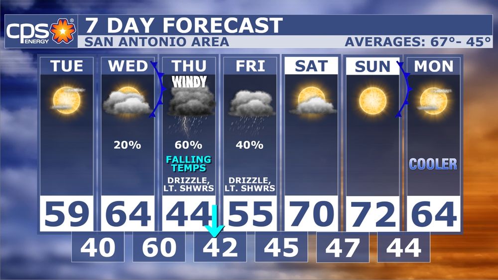
REST OF THE WEEK: Enjoy the sunshine today because clouds roll in overnight. A cold front expected to arrive early Thursday morning will cause temps to fall during the day. It will be wet, cold, and windy. Isolated storms possible too. Wind chills in the afternoon could be in the upper 30s.
December 2, 2025 at 7:22 PM
REST OF THE WEEK: Enjoy the sunshine today because clouds roll in overnight. A cold front expected to arrive early Thursday morning will cause temps to fall during the day. It will be wet, cold, and windy. Isolated storms possible too. Wind chills in the afternoon could be in the upper 30s.
THAT'S ALL SHE WROTE: Yesterday, was the end of the 2025 tropical season. Here is the recap. It was a near average season with 13 tropical name storms. This included 5 hurricanes and 4 major hurricanes (category 3 or higher).


December 1, 2025 at 6:28 PM
THAT'S ALL SHE WROTE: Yesterday, was the end of the 2025 tropical season. Here is the recap. It was a near average season with 13 tropical name storms. This included 5 hurricanes and 4 major hurricanes (category 3 or higher).
24 HOUR TEMP CHANGE: As of 6pm, San Antonio is 23° colder than this time yesterday. This is indicative of the colder air that is currently in place across South Texas.

December 1, 2025 at 12:09 AM
24 HOUR TEMP CHANGE: As of 6pm, San Antonio is 23° colder than this time yesterday. This is indicative of the colder air that is currently in place across South Texas.
RAINFALL TOTALS: Eastern and southern Bexar county were the winners last night. According to radar estimates some areas saw over 3". Other parts of the county completely missed out on it. If you missed out, rain chances are still in the forecast.

November 30, 2025 at 11:59 PM
RAINFALL TOTALS: Eastern and southern Bexar county were the winners last night. According to radar estimates some areas saw over 3". Other parts of the county completely missed out on it. If you missed out, rain chances are still in the forecast.
11:25PM: Cold front now moving into San Antonio. Expect winds to increase. There are also showers and isolated storms ahead of the front. Temperatures and humidity will be falling overnight.
November 30, 2025 at 5:29 AM
11:25PM: Cold front now moving into San Antonio. Expect winds to increase. There are also showers and isolated storms ahead of the front. Temperatures and humidity will be falling overnight.
8PM UPDATE: The front is in Central Texas at this hour. You'll notice when the front moves in a couple of hours. Future wind gusts show that they could be in excess of 40 mph. It will be a noisy overnight across South Texas.
November 30, 2025 at 2:18 AM
8PM UPDATE: The front is in Central Texas at this hour. You'll notice when the front moves in a couple of hours. Future wind gusts show that they could be in excess of 40 mph. It will be a noisy overnight across South Texas.
COLDER AIR MOVING SOUTH: It is warm and humid outside right now but in less than 12 hours temps will be falling. Showers and storms are possible in SA area tonight. Better chances will be east of SA. Wind gusts near 40 mph with wind chills in the 30s tomorrow morning. Get ready for big changes!


November 29, 2025 at 8:50 PM
COLDER AIR MOVING SOUTH: It is warm and humid outside right now but in less than 12 hours temps will be falling. Showers and storms are possible in SA area tonight. Better chances will be east of SA. Wind gusts near 40 mph with wind chills in the 30s tomorrow morning. Get ready for big changes!
DECEMBER: The beginning of the month looks to be cold across Texas. We have been flagged for the potential of our first freeze in San Antonio. On the 2nd image is what could be coming. Just note the cold air & not the actual air temps numbers because those will definitely change.


November 23, 2025 at 9:37 PM
DECEMBER: The beginning of the month looks to be cold across Texas. We have been flagged for the potential of our first freeze in San Antonio. On the 2nd image is what could be coming. Just note the cold air & not the actual air temps numbers because those will definitely change.
1:34PM: Front is now moving through Bexar county. You can notice the dew points are falling right behind it. Dew points in the 40s right now in the Hill Country.
November 21, 2025 at 7:35 PM
1:34PM: Front is now moving through Bexar county. You can notice the dew points are falling right behind it. Dew points in the 40s right now in the Hill Country.
7:17PM: More showers have developed in Bexar county over the past 30 minutes. These are slowly drifting northeast.
November 21, 2025 at 1:20 AM
7:17PM: More showers have developed in Bexar county over the past 30 minutes. These are slowly drifting northeast.
4:36PM: Showers and storms are approaching from the west. Expect moderate to heavy rain, lightning, some gusty winds, and small hail possible.
November 20, 2025 at 10:38 PM
4:36PM: Showers and storms are approaching from the west. Expect moderate to heavy rain, lightning, some gusty winds, and small hail possible.
FLOOD WATCH UPDATE: NWS has removed Bexar county from the Flood Watch. They expect the heavier rains to stay mainly west of San Antonio and in the Hill Country. We still have a chance for showers and storms in our forecast so stay weather aware through Friday morning.
November 20, 2025 at 6:19 PM
FLOOD WATCH UPDATE: NWS has removed Bexar county from the Flood Watch. They expect the heavier rains to stay mainly west of San Antonio and in the Hill Country. We still have a chance for showers and storms in our forecast so stay weather aware through Friday morning.
FUTURE RADAR: Here is what our in house weather model is showing as we move through the next 4 days. Note that at times, some rain could range from isolated to numerous across South Texas. As mentioned in my previous post, the higher rain totals will be west of San Antonio.
November 19, 2025 at 9:17 PM
FUTURE RADAR: Here is what our in house weather model is showing as we move through the next 4 days. Note that at times, some rain could range from isolated to numerous across South Texas. As mentioned in my previous post, the higher rain totals will be west of San Antonio.
FLASH FLOOD THREAT UPGRADED: A short time ago in coordination with our NWS office, the Weather Prediction Center upgraded areas west of San Antonio into a Moderate Risk for flash flooding. Models show some areas could receive 5"+ through Thursday. Stay weather aware!


November 19, 2025 at 7:55 PM
FLASH FLOOD THREAT UPGRADED: A short time ago in coordination with our NWS office, the Weather Prediction Center upgraded areas west of San Antonio into a Moderate Risk for flash flooding. Models show some areas could receive 5"+ through Thursday. Stay weather aware!
FLOOD WATCH: Has been issued for Bexar county going into effect Thursday morning through Friday morning. Average rainfall totals from 1-3" with isolated higher amounts.


November 18, 2025 at 6:29 PM
FLOOD WATCH: Has been issued for Bexar county going into effect Thursday morning through Friday morning. Average rainfall totals from 1-3" with isolated higher amounts.
LATER THIS WEEK: Rain and storms are still in the forecast for Thursday. Per my previous post I still see the possibility of some strong to severe storms. One model shows we could see waves of rain and storms on Thursday. We have been flagged for the potential for flash flooding on Thursday.


November 17, 2025 at 9:27 PM
LATER THIS WEEK: Rain and storms are still in the forecast for Thursday. Per my previous post I still see the possibility of some strong to severe storms. One model shows we could see waves of rain and storms on Thursday. We have been flagged for the potential for flash flooding on Thursday.
A LOOK AHEAD: An upper level low is expected to go over Texas late next week. Models are indicating all modes of severe weather will be possible from large hail, damaging winds, and tornadoes. Heavy rain also possible. Timing could change on when storms arrive so be weather aware late next week.


November 14, 2025 at 8:28 PM
A LOOK AHEAD: An upper level low is expected to go over Texas late next week. Models are indicating all modes of severe weather will be possible from large hail, damaging winds, and tornadoes. Heavy rain also possible. Timing could change on when storms arrive so be weather aware late next week.
NEXT 7 DAYS: We have warm temperatures in the forecast. Record high possible on Sunday. Rain chances going up late next week. There also could be strong to severe storms as well. I'll be keeping an eye on that.

November 14, 2025 at 2:59 PM
NEXT 7 DAYS: We have warm temperatures in the forecast. Record high possible on Sunday. Rain chances going up late next week. There also could be strong to severe storms as well. I'll be keeping an eye on that.
RED FLAG WARNING: On Veterans Day, strong southerly winds will contribute to high fire threat. A Red Flag Warning has been issued for most of South Texas starting tomorrow morning at 9am.


November 10, 2025 at 7:24 PM
RED FLAG WARNING: On Veterans Day, strong southerly winds will contribute to high fire threat. A Red Flag Warning has been issued for most of South Texas starting tomorrow morning at 9am.
FREEZE WARNING: Issued for the Hill Country overnight tonight. Low temps in Bexar county are expected to stay above freezing. However, tomorrow morning around sunrise, wind chills will make it feel like near/below freezing in parts of the county. High temps will rebound into the mid 60s for highs.


November 10, 2025 at 1:01 AM
FREEZE WARNING: Issued for the Hill Country overnight tonight. Low temps in Bexar county are expected to stay above freezing. However, tomorrow morning around sunrise, wind chills will make it feel like near/below freezing in parts of the county. High temps will rebound into the mid 60s for highs.
TIED THE HIGH: AS 2:25pm, the current temp of 88° at San Antonio Int'l ties the record for the date. We still could go higher. Also, a Fire Weather Watch was issued for South Texas ahead of a strong cold front that is expected on Sunday. This will more than likely be upgraded to a Red Flag Warning.


November 7, 2025 at 8:35 PM
TIED THE HIGH: AS 2:25pm, the current temp of 88° at San Antonio Int'l ties the record for the date. We still could go higher. Also, a Fire Weather Watch was issued for South Texas ahead of a strong cold front that is expected on Sunday. This will more than likely be upgraded to a Red Flag Warning.
THIS WEEK: We have a few chilly mornings but afternoons will be getting warmer each day. In fact, we will be near record highs on Friday. We still do need rain. Unfortunately, there is none in the 7 day forecast.

November 3, 2025 at 6:33 PM
THIS WEEK: We have a few chilly mornings but afternoons will be getting warmer each day. In fact, we will be near record highs on Friday. We still do need rain. Unfortunately, there is none in the 7 day forecast.
7:27PM: Most of the severe storms are in South Texas. There are still showers in Central Texas moving south. We still have a chance for those to make it to San Antonio but I don't anticipate severe storms.
November 2, 2025 at 12:30 AM
7:27PM: Most of the severe storms are in South Texas. There are still showers in Central Texas moving south. We still have a chance for those to make it to San Antonio but I don't anticipate severe storms.
5:52PM: This 2 hour loop shows how storms rapidly developed in the San Antonio metro area. Storms near Seguin are severe with quarter size hail being the main threat. Storm in eastern Bexar is also strong with hail indicated. Storm over Boerne moving SE also strong.
November 1, 2025 at 10:57 PM
5:52PM: This 2 hour loop shows how storms rapidly developed in the San Antonio metro area. Storms near Seguin are severe with quarter size hail being the main threat. Storm in eastern Bexar is also strong with hail indicated. Storm over Boerne moving SE also strong.