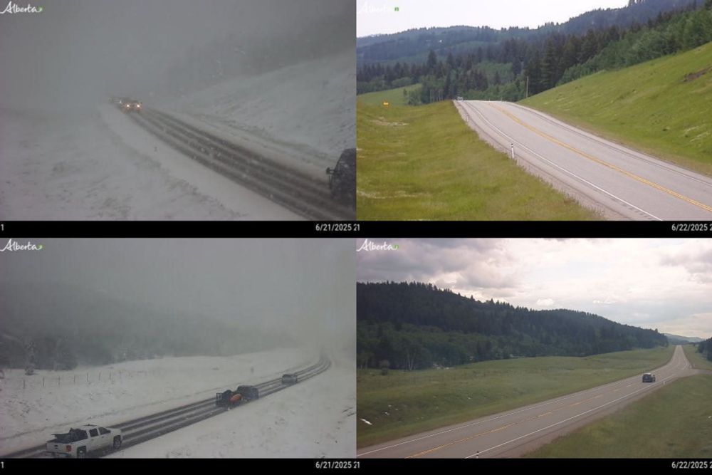
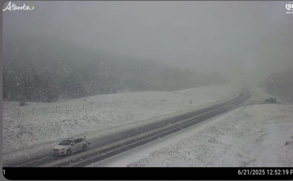
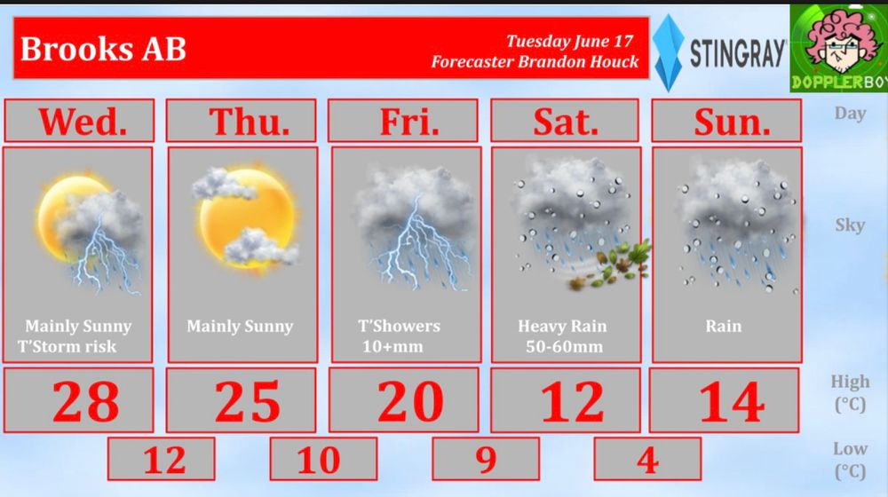
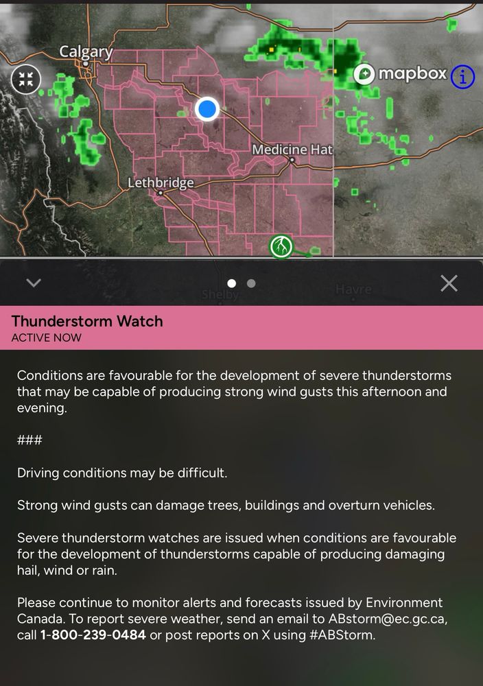
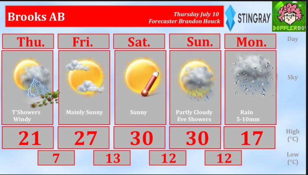
Brandon Houck
@houckispokisewx.bsky.social
610 followers 550 following 420 posts
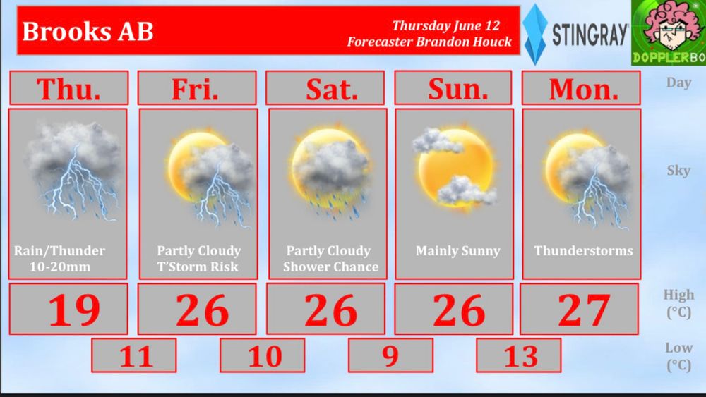
Weather Specialist/ radio producer Brooks Bandits Stingray radio New Country 105.7, Boom 101.1, New Country Southwest Alberta
Posts Media Videos Starter Packs
Reposted by Brandon Houck
cjthadj.bsky.social
cjthadj.bsky.social
Saturday, September 13:
Daylight stands at 12h38m50s, down 3m19s from yesterday and now 3h14m16s shorter than the solstice. Across New Brunswick, stable skies persist with near-seasonal temperatures. The autumnal equinox is just 9 days away.

#NBwx #FallCountdown #NewBrunswick
#ShareYourWeather
Reposted by Brandon Houck
cjthadj.bsky.social
cjthadj.bsky.social
August 7: 14h36m of daylight—now 1h18m below the solstice. Above-seasonal temps continue across NB under mainly sunny skies. Strong sun supports localized warming. Stable conditions persist. Autumnal equinox is 46 days away. #Neqotkuk #WaxingGibbous
#ShareYourWeather
Reposted by Brandon Houck
cdnhistoryehx.bsky.social
On July 31, 1987, an F4 (possibly an F5) tornado hit the eastern parts of Edmonton and Strathcona County.
It left 27 dead, injured 300 and caused $332 million in damages.
This is the story of Black Friday.

📸 Steve Simon

🧵 1/12
The provided photo shows the iconic image of the 1987 Edmonton tornado, captured by photographer Steve Simon. It depicts a large, wedge-shaped funnel cloud descending from a dark storm sky, touching down over an industrial area known as Refinery Row in eastern Edmonton, Alberta. The tornado appears as a bright, contrasting formation against the blackened background, with buildings, utility poles, and structures visible in the foreground.
Reposted by Brandon Houck
cjthadj.bsky.social
cjthadj.bsky.social
July 30 brings 14h57m40s of daylight—now under 15h and 56m26s below the solstice peak. Seasonal temps return under mostly cloudy skies. While stable overall, scattered showers may develop later. Daylight continues its gradual decline. The autumnal equinox is 54 days away. #Neqotkuk #Sunset
Reposted by Brandon Houck
cjthadj.bsky.social
cjthadj.bsky.social
On July 16, daylight holds at 15h 28m 57s—25m 9s below the solstice max. Above-seasonal temps persist with sunny, smoky skies across NB. Despite haze, solar input supports localized warming. Daylight slowly declines. Autumnal equinox is 68 days away.
#Neqotkuk #Tobique #GoldenHour
houckispokisewx.bsky.social
Pic of the day; Shelf cloud west of Lonebutte and south of Hanna AB on July 9 2025 pic taken by Carly Cruikshank
houckispokisewx.bsky.social
Pic of the day; Supercell near Orkney AB yesterday pic taken by Alisha Ferguson
houckispokisewx.bsky.social
Heat returns this weekend with rain likely by early next week #Brooks 5 Day Forecast
Reposted by Brandon Houck
cjthadj.bsky.social
cjthadj.bsky.social
On July 10, daylight holds at 15h 39m 4s—15m below the solstice peak. Below-seasonal temps persist with partly cloudy skies this morning and scattered showers by afternoon. Daylight continues its gradual decline. The autumnal equinox is 74 days away.
#Neqotkuk #Tobique #BuckMoon
houckispokisewx.bsky.social
Pic of the day; Severe thunderstorm near Rosemary AB on July 3 2025 pic taken by Tammy Karasek
Reposted by Brandon Houck
weatherhistory.bsky.social
June 23rd, 2007:

A massive and likely violent F3 struck rural areas near Pipestone, Manitoba.

This enormous wedge reached a peak width of around 1.18 miles wide during its 60 km trek.

This tornado was part of the multi-day sequence that also spawned the Elie F5.
A zoomed in view of the multi-vortex tornado.
Reposted by Brandon Houck
cdnhistoryehx.bsky.social
June 23, 1946:
At 10:15 a.m., a 7.0 to 7.5 magnitude earthquake struck near Courtenay, British Columbia. The shaking was felt as far away as Prince Rupert and Portland. It remains Canada's largest historic onshore earthquake. The earthquake caused two deaths.
Reposted by Brandon Houck
cmcalgary.bsky.social
Hwy 22 just south of Chain Lakes reservoir had snow yesterday, but it's gone already. Weather is fun.

#Alberta
4x screenshots of a traffic camera. The pics from yesterday were covered in snow (the two images on the left). Today is all clear and sunny.
houckispokisewx.bsky.social
Update on conditions near Brooks #abstorm
houckispokisewx.bsky.social
Snow along Highway 22 at Chain Lakes #abstorm
houckispokisewx.bsky.social
Risk of severe thunderstorms today, the weekend is looking very wet and windy #Brooks 5 Day Forecast
houckispokisewx.bsky.social
Probably won’t be a repeat of 2013 that year had high amounts of snow in the Rockies + plus a rapid melt and 200-300mm of rain… Snow levels are much lower this year. Some overland is flooding in fields are possible but I don’t think it will be anything like what we saw that year :)
houckispokisewx.bsky.social
Severe Thunderstorm Watch for parts of Southern Alberta
houckispokisewx.bsky.social
Pic of the day; Incredible shelf cloud on a thunderstorm near Cluny AB on June 15 2025 pic taken by Naomi Zacharias
houckispokisewx.bsky.social
Pic of the day; Lightning strike yesterday near Hussar AB pic taken by Joshua Palmer
houckispokisewx.bsky.social
Pic of the day; Thunderstorm early yesterday morning near Brooks AB pic taken by Laurie Baron
houckispokisewx.bsky.social
Pic of the day; Full Strawberry Moon over Brooks AB yesterday morning pic taken by Brenda Jones
houckispokisewx.bsky.social
Showers risk of thunderstorms into the weekend #Brooks 5 Day Forecast
houckispokisewx.bsky.social
Pic of the day; Deer peaking through the bushes in Prince George BC on June 7 2025 pic taken by Karen Richards
houckispokisewx.bsky.social
In the parade today #Brooks