


Aly Ollivierre
@alyolli.bsky.social
Award-winning Freelance Cartographer @tombolomapsdesign.bsky.social | Ex-NatGeo Senior Cartographer
Pinned
Aly Ollivierre
@alyolli.bsky.social
· Jul 21

Home
Alison DeGraff Ollivierre Portfolio
www.alyollivierre.com
I'm on the job market and #opentowork looking for full-time opportunities in #cartography #GIS. Please help me find an amazing job! In the meantime, I will continue offering my freelance services through @tombolomapsdesign.bsky.social, so please send any potential clients my way!
Reposted by Aly Ollivierre

For Day 10 of the #30DayMapChallenge's prompt "Air" we're resharing a map we made last year to cope with the anxiety of waiting to hear from family and friends in the transboundary Grenadines following the direct hit by Hurricane Beryl on July 1, 2024.

November 11, 2025 at 4:58 AM
For Day 10 of the #30DayMapChallenge's prompt "Air" we're resharing a map we made last year to cope with the anxiety of waiting to hear from family and friends in the transboundary Grenadines following the direct hit by Hurricane Beryl on July 1, 2024.
Reposted by Aly Ollivierre
For the #30DayMapChallenge Day 9's prompt "Analog" we wanted to share some of the map jewelry we've made over the years, particularly our custom, handmade, geospatially accurate—but wonderfully, uniquely imperfect—jewelry. (If you're interested, reach out at [email protected]!)


November 11, 2025 at 4:53 AM
For the #30DayMapChallenge Day 9's prompt "Analog" we wanted to share some of the map jewelry we've made over the years, particularly our custom, handmade, geospatially accurate—but wonderfully, uniquely imperfect—jewelry. (If you're interested, reach out at [email protected]!)
For the #30DayMapChallenge Day 9's prompt "Analog" I sketched out a quick, small-child-friendly map and let my kiddo color it in 😋


November 11, 2025 at 4:46 AM
For the #30DayMapChallenge Day 9's prompt "Analog" I sketched out a quick, small-child-friendly map and let my kiddo color it in 😋
Reposted by Aly Ollivierre
For Day 8 of the #30DayMapChallenge's prompt "Urban", we refreshed a map of Kingstown, the capital of Saint Vincent and the Grenadines, visualizing the impact of 2m sea level rise on essential services downtown, that was originally published in Guerrilla Cartography's “Water: An Atlas".

November 11, 2025 at 4:43 AM
For Day 8 of the #30DayMapChallenge's prompt "Urban", we refreshed a map of Kingstown, the capital of Saint Vincent and the Grenadines, visualizing the impact of 2m sea level rise on essential services downtown, that was originally published in Guerrilla Cartography's “Water: An Atlas".
Reposted by Aly Ollivierre

Do I know any Indigenous folks who make maps? Got a request for a paid design/cartography job and it'd be rad if I could connect you with them.
November 8, 2025 at 1:01 AM
Do I know any Indigenous folks who make maps? Got a request for a paid design/cartography job and it'd be rad if I could connect you with them.
Reposted by Aly Ollivierre
For Day 6 "Dimensions" of #30DayMapChallenge, we are going to brag about the GIS+Blender course we took from Elizabeth Rosenbloom. After only 5hrs of learning the UI and ways to work with geospatial data within the software, we were able to make this sunrise rending of the Galapagos Islands 🌅

November 9, 2025 at 8:32 PM
For Day 6 "Dimensions" of #30DayMapChallenge, we are going to brag about the GIS+Blender course we took from Elizabeth Rosenbloom. After only 5hrs of learning the UI and ways to work with geospatial data within the software, we were able to make this sunrise rending of the Galapagos Islands 🌅
Reposted by Aly Ollivierre
For Day 5 "Earth" we refreshed a Pacific bathymetry map we made for our own "Map-A-Day" project (many years before the #30DayMapChallenge existed) to build up our original portfolio!

November 9, 2025 at 8:29 PM
For Day 5 "Earth" we refreshed a Pacific bathymetry map we made for our own "Map-A-Day" project (many years before the #30DayMapChallenge existed) to build up our original portfolio!
Reposted by Aly Ollivierre
For Day 4 "My Data" of the #30DayMapChallenge we refreshed a map @alyolli.bsky.social made almost a decade ago while living in Portland, Maine after a day trip via ferry to walk around Peaks Island with two wonderful childhood friends (and a trusty old chunky Garmin GPS 😉)!

November 9, 2025 at 8:29 PM
For Day 4 "My Data" of the #30DayMapChallenge we refreshed a map @alyolli.bsky.social made almost a decade ago while living in Portland, Maine after a day trip via ferry to walk around Peaks Island with two wonderful childhood friends (and a trusty old chunky Garmin GPS 😉)!
Reposted by Aly Ollivierre
For our next map for the #30DayMapChallenge, for Day 3's prompt "Polygons", we made a quick map of Burlington, Vermont!

November 9, 2025 at 8:28 PM
For our next map for the #30DayMapChallenge, for Day 3's prompt "Polygons", we made a quick map of Burlington, Vermont!
Reposted by Aly Ollivierre
Another quick map for the #30DayMapChallenge for the prompt "Lines"! We grabbed Magnificent Frigatebird tracking data from Movebank and highlighted one of their tagged birds, "Boyd", who demonstrates the vast distances this species can explore while foraging.

November 9, 2025 at 8:28 PM
Another quick map for the #30DayMapChallenge for the prompt "Lines"! We grabbed Magnificent Frigatebird tracking data from Movebank and highlighted one of their tagged birds, "Boyd", who demonstrates the vast distances this species can explore while foraging.
Reposted by Aly Ollivierre
We're going to try and keep things QUICK and SIMPLE for the #30DayMapChallenge this year! So here, for Day 1 of the Challenge, is our response to the prompt "Points", showing all the trees in and around Cheesman Park where @alyolli.bsky.social lived for her first half decade in Colorado!

November 9, 2025 at 8:26 PM
We're going to try and keep things QUICK and SIMPLE for the #30DayMapChallenge this year! So here, for Day 1 of the Challenge, is our response to the prompt "Points", showing all the trees in and around Cheesman Park where @alyolli.bsky.social lived for her first half decade in Colorado!
Reposted by Aly Ollivierre

After months, I finally remembered to put this print on my store page, so that people know where to look if they want a charmingly distressing world map.
somethingaboutmaps.com/Storefront
And if you'll be at #NACIS2025 in Louisville, you can see it in person and deface it with dry erase markers.
somethingaboutmaps.com/Storefront
And if you'll be at #NACIS2025 in Louisville, you can see it in person and deface it with dry erase markers.


September 25, 2025 at 8:58 PM
After months, I finally remembered to put this print on my store page, so that people know where to look if they want a charmingly distressing world map.
somethingaboutmaps.com/Storefront
And if you'll be at #NACIS2025 in Louisville, you can see it in person and deface it with dry erase markers.
somethingaboutmaps.com/Storefront
And if you'll be at #NACIS2025 in Louisville, you can see it in person and deface it with dry erase markers.
Reposted by Aly Ollivierre

Kicking off #NACIS2025 with @cchurchili.bsky.social & “Advanced Terrain Modeling with Blender”. If you’re unfamiliar his work, it’s amazing: churchillgeo.com

October 15, 2025 at 1:10 PM
Kicking off #NACIS2025 with @cchurchili.bsky.social & “Advanced Terrain Modeling with Blender”. If you’re unfamiliar his work, it’s amazing: churchillgeo.com
Reposted by Aly Ollivierre
Bringing life to maps with motion — the amazing @sarahbell.bsky.social Animating Maps with After Effects
www.sarahbellmaps.com/animated-fly...
#NACIS2025
www.sarahbellmaps.com/animated-fly...
#NACIS2025
Animated Flyover Map in ArcGIS Pro and Adobe After Effects – Sarah Bell Maps
www.sarahbellmaps.com
October 15, 2025 at 2:58 PM
Bringing life to maps with motion — the amazing @sarahbell.bsky.social Animating Maps with After Effects
www.sarahbellmaps.com/animated-fly...
#NACIS2025
www.sarahbellmaps.com/animated-fly...
#NACIS2025
Reposted by Aly Ollivierre

October 16, 2025 at 6:12 PM
Reposted by Aly Ollivierre
The Alliance of Freelance Cartographers has a new website! Thanks to @alyolli.bsky.social for getting it off the ground. It hosts past editions of the survey, as well as other resources. www.freelancemaps.org/home

September 23, 2025 at 8:28 PM
The Alliance of Freelance Cartographers has a new website! Thanks to @alyolli.bsky.social for getting it off the ground. It hosts past editions of the survey, as well as other resources. www.freelancemaps.org/home
Reposted by Aly Ollivierre

Happy to share the release of the 2nd edition of Mapping, Society, and Technology. Props to @smmanson.bsky.social for wranging multiple of us to update it. It's a free text suitable for many introductory GIS courses, hosted at UMN Libraries. open.lib.umn.edu/mapping/ #gischat

Mapping, Society, and Technology – Simple Book Publishing
Exploring relationships among maps, society, and technology
open.lib.umn.edu
August 7, 2025 at 1:17 PM
Happy to share the release of the 2nd edition of Mapping, Society, and Technology. Props to @smmanson.bsky.social for wranging multiple of us to update it. It's a free text suitable for many introductory GIS courses, hosted at UMN Libraries. open.lib.umn.edu/mapping/ #gischat
Reposted by Aly Ollivierre

Jerry added great material throughout the book, joining work from other contributing authors. Shout out to Dudley Bonsal, @alyolli.bsky.social, Eric DeLuca, Rachael Huerta Carpenter, Jennifer Immich, Melinda Kernik, Steven Manson, Laura Matson, Sara Holiday Nelson, and Julie Santella.
Happy to share the release of the 2nd edition of Mapping, Society, and Technology. Props to @smmanson.bsky.social for wranging multiple of us to update it. It's a free text suitable for many introductory GIS courses, hosted at UMN Libraries. open.lib.umn.edu/mapping/ #gischat
Mapping, Society, and Technology – Simple Book Publishing
Exploring relationships among maps, society, and technology
open.lib.umn.edu
August 7, 2025 at 9:02 PM
Jerry added great material throughout the book, joining work from other contributing authors. Shout out to Dudley Bonsal, @alyolli.bsky.social, Eric DeLuca, Rachael Huerta Carpenter, Jennifer Immich, Melinda Kernik, Steven Manson, Laura Matson, Sara Holiday Nelson, and Julie Santella.
Reposted by Aly Ollivierre

Five days remain to take advantage of early bird discount rates for GIS-Pro in the Rockies! Don't miss the opportunity to learn, connect, and be inspired in Denver in October.
Make your plans ASAP: thegpn.org/page/GIS-Pro
Make your plans ASAP: thegpn.org/page/GIS-Pro

July 28, 2025 at 2:22 PM
Five days remain to take advantage of early bird discount rates for GIS-Pro in the Rockies! Don't miss the opportunity to learn, connect, and be inspired in Denver in October.
Make your plans ASAP: thegpn.org/page/GIS-Pro
Make your plans ASAP: thegpn.org/page/GIS-Pro
Reposted by Aly Ollivierre
Still working on editing the paper, but thanks to @southarrowmaps.co.nz, we've now got a method that seems to work from any viewing angle, allowing animation doodles like this.
July 31, 2025 at 7:24 PM
Still working on editing the paper, but thanks to @southarrowmaps.co.nz, we've now got a method that seems to work from any viewing angle, allowing animation doodles like this.
Reposted by Aly Ollivierre
Just wrapped up my latest side project: my first ever map of a #NationalPark. I illustrated #IsleRoyale, which sits in #LakeSuperior, in the semiautomated hachure style I've been developing this last year. More details, and a download, on the blog: somethingaboutmaps.wordpress.com/2025/07/28/a...


July 28, 2025 at 9:52 PM
Just wrapped up my latest side project: my first ever map of a #NationalPark. I illustrated #IsleRoyale, which sits in #LakeSuperior, in the semiautomated hachure style I've been developing this last year. More details, and a download, on the blog: somethingaboutmaps.wordpress.com/2025/07/28/a...
Reposted by Aly Ollivierre

Draw your own map of Uptown here. You get a neat social card to share when you submit your results!
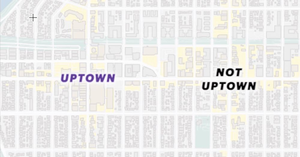
Draw your own map of Uptown
Tell us where your Uptown begins and ends: Lake and Lyndale? West of Bde Maka Ska?
Startribune.com
July 25, 2025 at 3:11 PM
Draw your own map of Uptown here. You get a neat social card to share when you submit your results!
Reposted by Aly Ollivierre

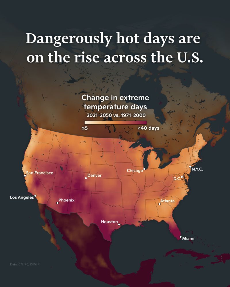
🌡️Have you been feeling the heat this week? Stay informed, hydrated, and safe!
Dangerously hot days are on the rise across the U.S. according to this map from @cmshintani.bsky.social. This week’s extreme temperatures are part of a larger trend of climate change.
Dangerously hot days are on the rise across the U.S. according to this map from @cmshintani.bsky.social. This week’s extreme temperatures are part of a larger trend of climate change.
July 25, 2025 at 5:34 PM
🌡️Have you been feeling the heat this week? Stay informed, hydrated, and safe!
Dangerously hot days are on the rise across the U.S. according to this map from @cmshintani.bsky.social. This week’s extreme temperatures are part of a larger trend of climate change.
Dangerously hot days are on the rise across the U.S. according to this map from @cmshintani.bsky.social. This week’s extreme temperatures are part of a larger trend of climate change.
Reposted by Aly Ollivierre

![Comic. The Most-Observed Animal and Plant in Each State on iNaturalist. (Not the most common species in the state, just the one people have reported the most times.) [labeled map of the US] WA: Mallard/Western Sword Fern. OR: Mule Deer/Western Ponderosa Pine. CA: Western Fence Lizard/California Poppy. HI: Green Sea Turtle/‘Ōhi’a Lehua. ID: Mallard/Big Sagebrush. NV: Common Side-Blotched Lizard/Creosote Bush. MT: White-Tailed Deer/Common Yarrow. WY: American Bison/Sticky Geranium. UT: Mule Deer/Utah Juniper. AZ: Ornate Tree Lizard/Saguaro. CO: Mule Deer/Great Mullein. NM: Mule Deer/Creosote Bush. AK: Moose/Fireweed. ND: American Bison/Prairie Rose. SD: American Bison/Hoary Vervain. NE: American Robin/Common Milkweed. KS: Ornate Box Turtle/Amur Honeysuckle. OK: Pond Slider/Eastern Redcedar. TX: Northern Cardinal/Pinladies. MN, WI, IL: Common Eastern Bumble Bee/Common Milkweed. IA, MI: White-Tailed Deer/Common Milkweed. MO: Brown-Belted Bumble Bee/Amur Honeysuckle. AR: Three-toed Box Turtle/Chinese Privet. LA: Green Anole/Baldcypress. IN: American Robin/Amur Honeysuckle. OH: Eastern Pondhawk/Virginia Springbeauty. KY: Common Box Turtle/Amur Honeysuckle. TN: American Robin/Christmas Fern. MS: Northern Cardinal/Pale Pitcher Plant. AL: Gulf Fritillary/American Sweetgum. GA: Green Anole/American Sweetgum. FL: Brown Anole/White Beggarticks. NY: Eastern Gray Squirrel/White Snakeroot. PA: White-Tailed Deer/Garlic Mustard. WV: White-Tailed Deer/Great Rhododendron. VA: White-Tailed Deer/Eastern Poison Ivy. MD: White-Tailed Deer/Wineberry. DE: Fowler’s Toad/American Pokeweed. NC: Eastern Gray Squirrel/Christmas Fern. SC: Northern Cardinal/American Sweetgum. NJ: Spotted Lanternfly/Common Mugwort. VT: Common Eastern Bumble Bee/Eastern White Pine. NH: White-Tailed Deer/Eastern White Pine. MA: Common Eastern Bumble Bee/Eastern White Pine. CT: Common Eastern Bumble Bee/Striped Wintergreen. RI: American Herring Gull. ME: American Herring Gull/Canadian Bunchberry.](https://cdn.bsky.app/img/feed_thumbnail/plain/did:plc:cz73r7iyiqn26upot4jtjdhk/bafkreic4f56ywseq7bqc7zza3y76pxyzn5c5htebrior6jdbrfszhuiquy@jpeg)
July 22, 2025 at 7:52 PM
Reposted by Aly Ollivierre
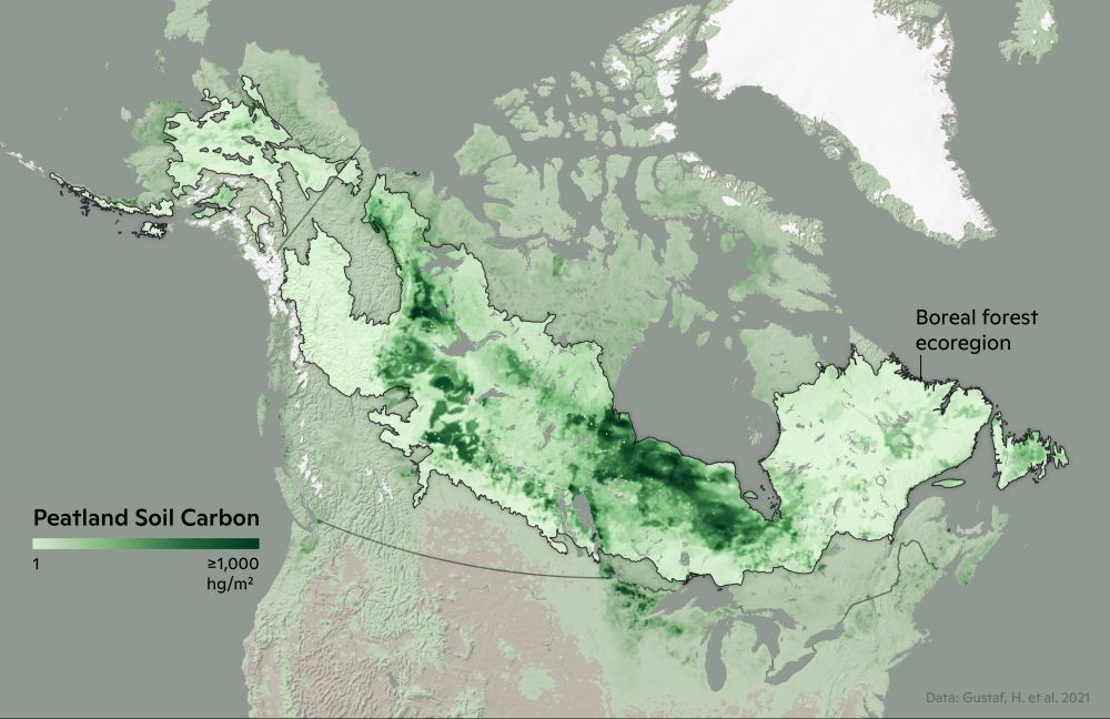
This #MapMonday from @cmshintani.bsky.social shows the carbon stores in peatland soil across the boreal forest ecoregion.
Read more at www.woodwellclimate.org/connection-b...
Read more at www.woodwellclimate.org/connection-b...
July 21, 2025 at 5:21 PM
This #MapMonday from @cmshintani.bsky.social shows the carbon stores in peatland soil across the boreal forest ecoregion.
Read more at www.woodwellclimate.org/connection-b...
Read more at www.woodwellclimate.org/connection-b...