


DPME
@angloswissguy.bsky.social
Executive Chair @Swiss Church London | Trustee @Jubilee Gardens Trust | Managing Director Europe @ENTTEC | London & West Sussex
Reposted by DPME
Warm air in association with #StormBran tomorrow might destroy highest max records for Dec 9th by 3C in east. Might see a 16-17C. Remarkable and doubly so given the ☁️ conditions.


December 8, 2025 at 8:51 PM
Warm air in association with #StormBran tomorrow might destroy highest max records for Dec 9th by 3C in east. Might see a 16-17C. Remarkable and doubly so given the ☁️ conditions.
Reposted by DPME

Why is it so unsettled at the moment?
A powerful jet stream will continue to drive our weather into next week and may help to rapidly deepen an area of low pressure later on Monday and into Tuesday.
A powerful jet stream will continue to drive our weather into next week and may help to rapidly deepen an area of low pressure later on Monday and into Tuesday.
December 6, 2025 at 1:14 PM
Why is it so unsettled at the moment?
A powerful jet stream will continue to drive our weather into next week and may help to rapidly deepen an area of low pressure later on Monday and into Tuesday.
A powerful jet stream will continue to drive our weather into next week and may help to rapidly deepen an area of low pressure later on Monday and into Tuesday.
Reposted by DPME

Hurricane Melissa is a record breaker.
210kt gust recorded above the surface setting a new world record, previous was 209kts by Typhoon Megi (2010)
The eye is now down to -5.21 making it the driest eye in Atlantic basin history, the world record is -5.00.
What a beast.
210kt gust recorded above the surface setting a new world record, previous was 209kts by Typhoon Megi (2010)
The eye is now down to -5.21 making it the driest eye in Atlantic basin history, the world record is -5.00.
What a beast.

October 27, 2025 at 4:10 PM
Hurricane Melissa is a record breaker.
210kt gust recorded above the surface setting a new world record, previous was 209kts by Typhoon Megi (2010)
The eye is now down to -5.21 making it the driest eye in Atlantic basin history, the world record is -5.00.
What a beast.
210kt gust recorded above the surface setting a new world record, previous was 209kts by Typhoon Megi (2010)
The eye is now down to -5.21 making it the driest eye in Atlantic basin history, the world record is -5.00.
What a beast.


The problem #Trump faces after his second UK state visit is Windsor Castle. He must be thinking “I need to get myself a castle like this!”

September 18, 2025 at 6:31 AM
The problem #Trump faces after his second UK state visit is Windsor Castle. He must be thinking “I need to get myself a castle like this!”
Free speech seemingly died in the US last night. Democracy will be assigned to history. #JimmyKimmel
September 18, 2025 at 6:25 AM
Free speech seemingly died in the US last night. Democracy will be assigned to history. #JimmyKimmel
Sun and showers and another beautiful Sunday sunrise


September 14, 2025 at 7:09 PM
Sun and showers and another beautiful Sunday sunrise
Leaving London soon. Will miss this morning view ❤️

September 12, 2025 at 9:31 AM
Leaving London soon. Will miss this morning view ❤️
The Trump administration is removing ocean and air pollution monitoring instruments from NOAA’s next-generation weather satellites and cutting the satellite constellation from six to four satellites.
August 21, 2025 at 8:25 AM
The Trump administration is removing ocean and air pollution monitoring instruments from NOAA’s next-generation weather satellites and cutting the satellite constellation from six to four satellites.
Reposted by DPME

Swarm of jellyfish shuts French nuclear plant reut.rs/3Jc7S0y
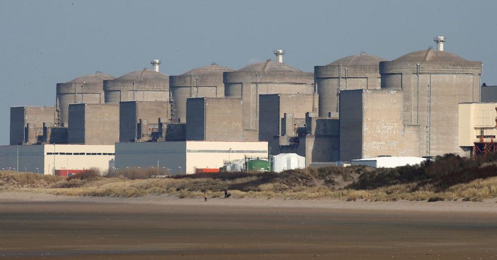
Swarm of jellyfish shuts French nuclear plant
Four reactors at France's Gravelines nuclear power plant were shut down late Sunday due to a swarm of jellyfish in the filter drums that pull in cooling water, operator EDF said on Monday.
reut.rs
August 11, 2025 at 10:40 AM
Swarm of jellyfish shuts French nuclear plant reut.rs/3Jc7S0y
Reposted by DPME
Current temperatures are just shy of 30C in west London in early afternoon. It’s been 3 weeks since similar hot temps.
Hotter tomorrow expecting 33-34C highs thankfully accompanied with low humidity across inland areas. Southern coastal areas more humid.
Hotter tomorrow expecting 33-34C highs thankfully accompanied with low humidity across inland areas. Southern coastal areas more humid.


August 11, 2025 at 1:10 PM
Current temperatures are just shy of 30C in west London in early afternoon. It’s been 3 weeks since similar hot temps.
Hotter tomorrow expecting 33-34C highs thankfully accompanied with low humidity across inland areas. Southern coastal areas more humid.
Hotter tomorrow expecting 33-34C highs thankfully accompanied with low humidity across inland areas. Southern coastal areas more humid.
Reposted by DPME

Ok so we’re 316 off 6k signatures. Anyone who has signed who hasn’t managed to get a second person to sign, try get someone to this weekend so we can crack 6k. Then we’ve 6 weeks to get 4k more. We can do it. We have to. Over platforming of one party must stop petition.parliament.uk/petitions/71...
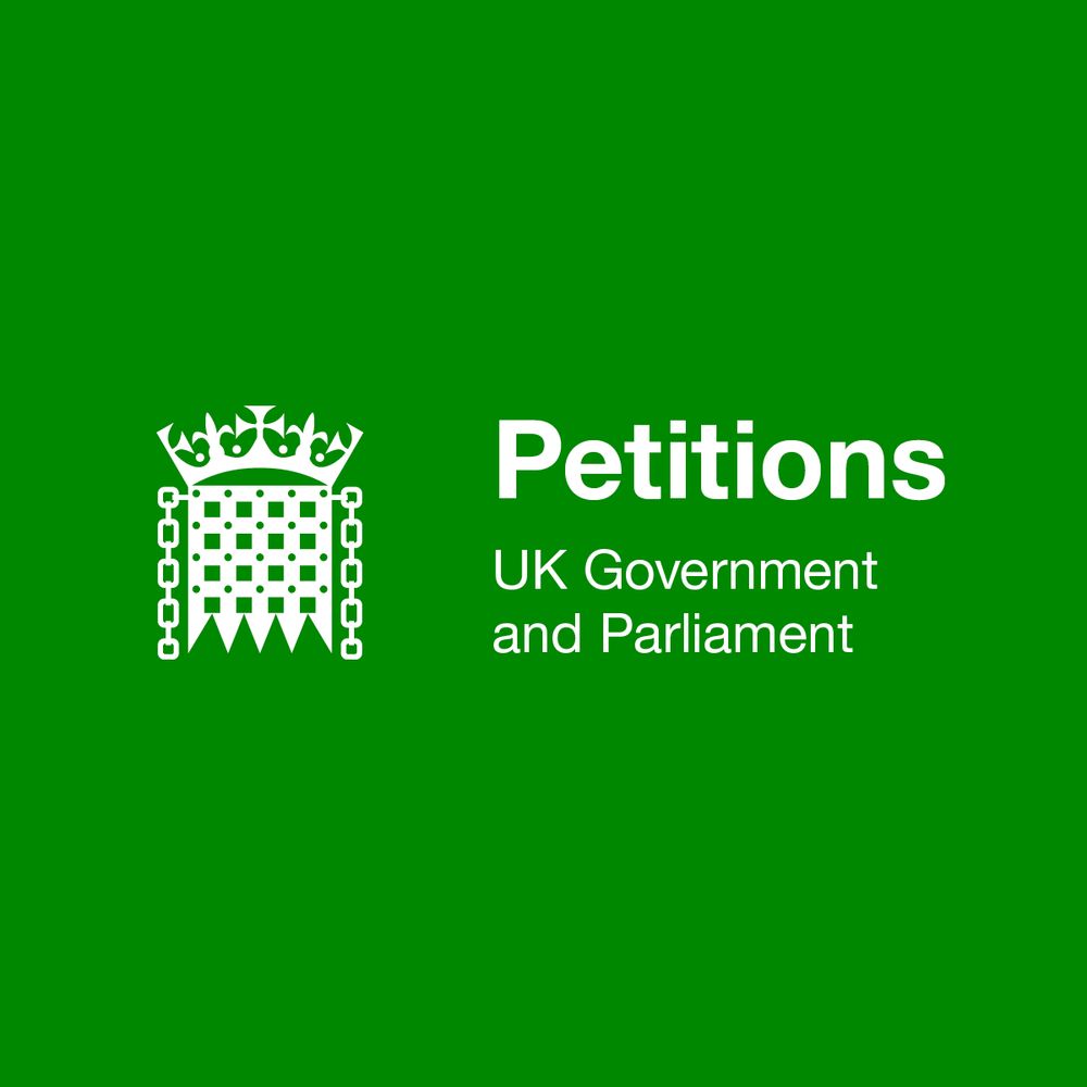
Petition: Ensure plurality of political coverage across UK broadcast media at all times
We want to ensure that a plurality of views from all political parties in Westminster are represented and the nations parliaments are heard all year round, not just election times. The rules for cover...
petition.parliament.uk
August 9, 2025 at 8:38 AM
Ok so we’re 316 off 6k signatures. Anyone who has signed who hasn’t managed to get a second person to sign, try get someone to this weekend so we can crack 6k. Then we’ve 6 weeks to get 4k more. We can do it. We have to. Over platforming of one party must stop petition.parliament.uk/petitions/71...
Reposted by DPME
Temperatures rising over the next few days, with it become hot and humid for some by Tuesday 🌡️
August 9, 2025 at 4:02 PM
Temperatures rising over the next few days, with it become hot and humid for some by Tuesday 🌡️
Reposted by DPME
This BBC item is about people living in idyllic villages in one of the richest countries of the world - far away from the oceans and the seas.
Climate change is global.
It doesn’t matter if you live by the coast, in a poor village, or in the mountains in a wealthy global capitalist mountain haven.
Climate change is global.
It doesn’t matter if you live by the coast, in a poor village, or in the mountains in a wealthy global capitalist mountain haven.
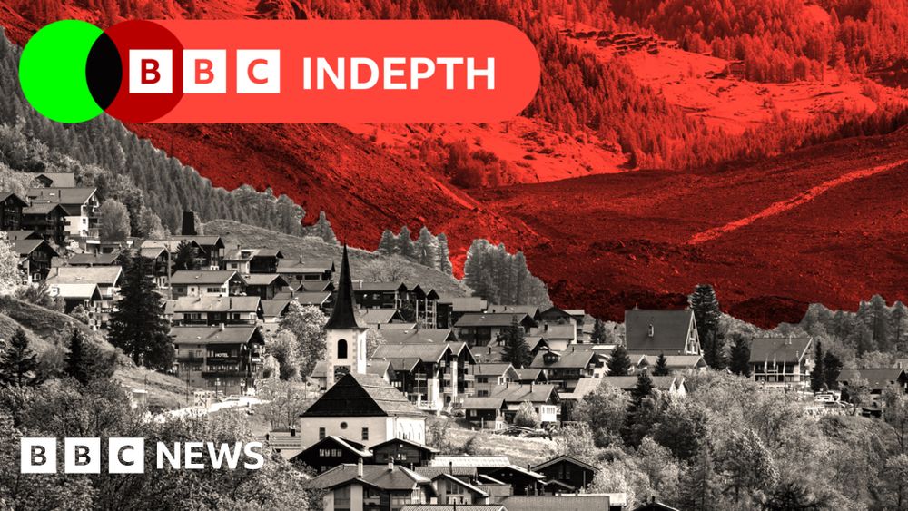
Why glaciers are threatening to wipe out more mountain villages
Switzerland spends almost $500m a year on protective structures. Is it worth it - or, as some suggest, should people move away from the mountain villages at risk?
www.bbc.com
August 3, 2025 at 7:00 AM
This BBC item is about people living in idyllic villages in one of the richest countries of the world - far away from the oceans and the seas.
Climate change is global.
It doesn’t matter if you live by the coast, in a poor village, or in the mountains in a wealthy global capitalist mountain haven.
Climate change is global.
It doesn’t matter if you live by the coast, in a poor village, or in the mountains in a wealthy global capitalist mountain haven.

www.threads.com/@brittainfor...
More insight from the smartest guy on Earth
More insight from the smartest guy on Earth

Craig R. Brittain (@brittainforsenate) on Threads
Trump: These are massive cavities in Earth, they took the oil out that we put in, they took it out before the election, as big as those cavities are, we call them cavities, caves, they're salt mines, ...
www.threads.com
July 23, 2025 at 9:59 AM
www.threads.com/@brittainfor...
More insight from the smartest guy on Earth
More insight from the smartest guy on Earth
www.resiliencemedia.co/p/the-long-r... why Europe needs an integrated and rapid approach to funding, scaling AI & R&D investment and how the private sector can protect from the rising risk of war

The Long Read: How Helsing Sees the World
During its first press day, Helsing offered an inside view into its technologies, team, and perspective on the threat landscape
www.resiliencemedia.co
July 21, 2025 at 5:21 PM
www.resiliencemedia.co/p/the-long-r... why Europe needs an integrated and rapid approach to funding, scaling AI & R&D investment and how the private sector can protect from the rising risk of war
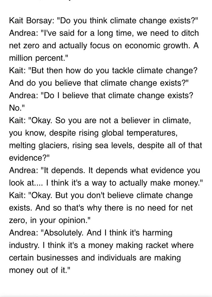
Proof, not that it’s actually required, that this so called political organisation and its elected officials are on the wrong side of the intellectual divide. As the USA has demonstrated, intelligence, ethics and public service are not necessarily prerequisites for high office.

Reform mayor Andrea Jenkyns tells Times Radio that she doesn’t believe climate change exists, and that it’s just a “racket” for some people to make money. If Reform win the next election, the UK could become a very different place quite quickly.
July 18, 2025 at 12:49 PM
Proof, not that it’s actually required, that this so called political organisation and its elected officials are on the wrong side of the intellectual divide. As the USA has demonstrated, intelligence, ethics and public service are not necessarily prerequisites for high office.
Reposted by DPME
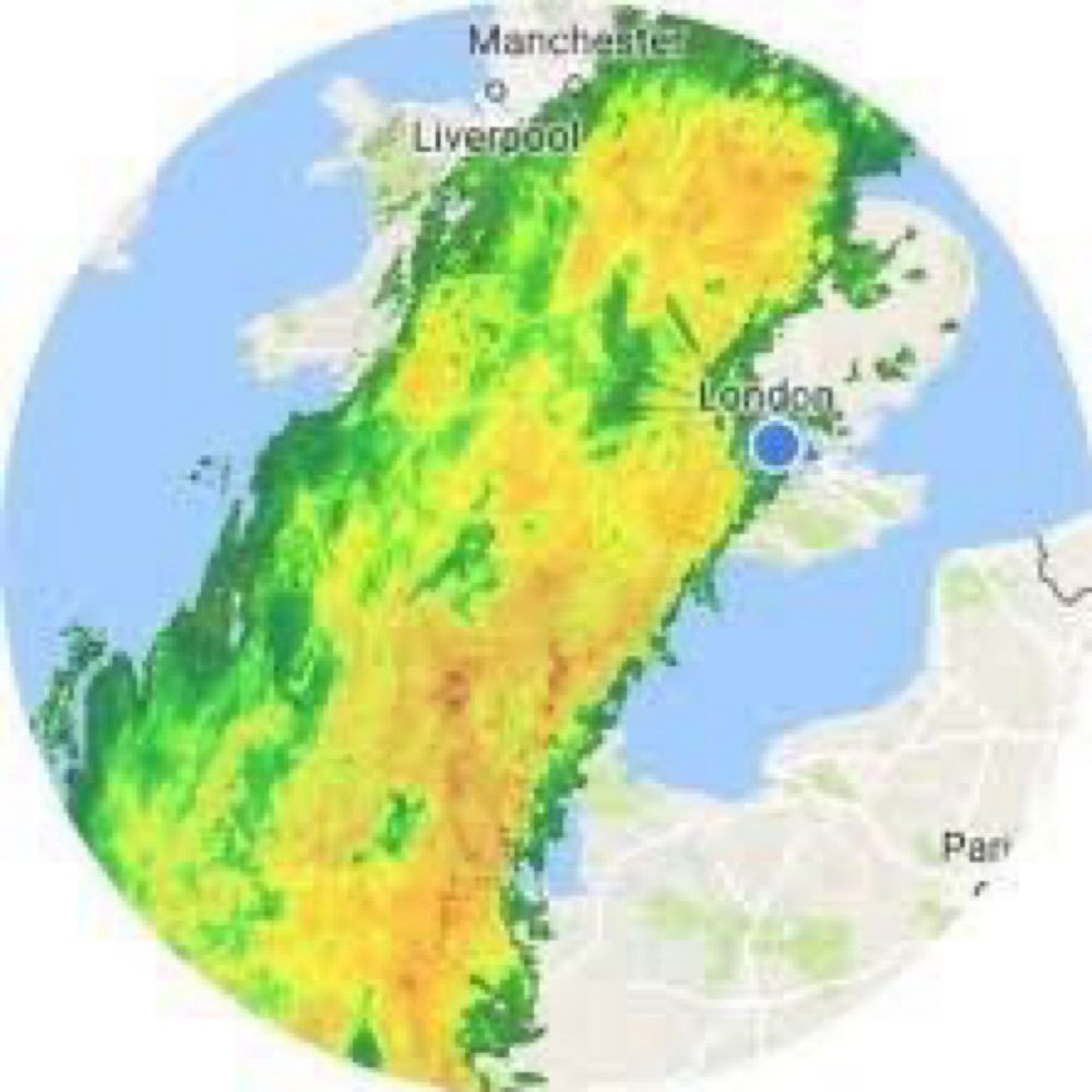
Right on cue…
almost comical the European model has 2” of rain across parts of SE by early next week. A serious fall of rain possible on Saturday with potential for surface water flooding. #SchoolHolidays
almost comical the European model has 2” of rain across parts of SE by early next week. A serious fall of rain possible on Saturday with potential for surface water flooding. #SchoolHolidays

July 17, 2025 at 7:17 PM
Right on cue…
almost comical the European model has 2” of rain across parts of SE by early next week. A serious fall of rain possible on Saturday with potential for surface water flooding. #SchoolHolidays
almost comical the European model has 2” of rain across parts of SE by early next week. A serious fall of rain possible on Saturday with potential for surface water flooding. #SchoolHolidays
Reposted by DPME
Heatwave incoming!🥵
Starting Thursday temperatures are likely to exceed 30ºC fairly widely until Tuesday / Wednesday next week. Quite a remarkable spell of hot weather on the way.
Starting Thursday temperatures are likely to exceed 30ºC fairly widely until Tuesday / Wednesday next week. Quite a remarkable spell of hot weather on the way.


July 7, 2025 at 10:20 AM
Heatwave incoming!🥵
Starting Thursday temperatures are likely to exceed 30ºC fairly widely until Tuesday / Wednesday next week. Quite a remarkable spell of hot weather on the way.
Starting Thursday temperatures are likely to exceed 30ºC fairly widely until Tuesday / Wednesday next week. Quite a remarkable spell of hot weather on the way.
Reposted by DPME
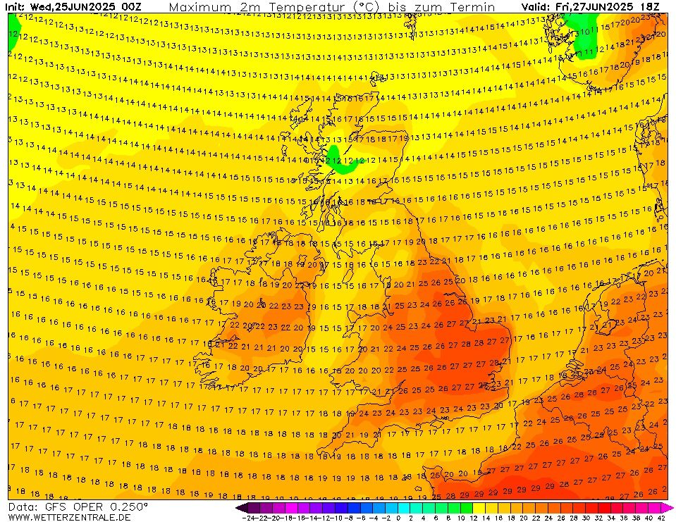
It's likely we will reach heatwave criteria Friday - Monday.
Temperatures likely to peak on Monday around 34-35°C, the all time June temperature record certainly under threat there (35.6C).
Temperatures likely to peak on Monday around 34-35°C, the all time June temperature record certainly under threat there (35.6C).


June 25, 2025 at 9:58 AM
It's likely we will reach heatwave criteria Friday - Monday.
Temperatures likely to peak on Monday around 34-35°C, the all time June temperature record certainly under threat there (35.6C).
Temperatures likely to peak on Monday around 34-35°C, the all time June temperature record certainly under threat there (35.6C).
Reposted by DPME

Another study that shows our warming climate will bring hotter and longer heatwaves to the UK, with the chance of exceeding 40C increasing.
▪️Chance of 40C or above in 1960 was around 0.2%
▪️Chance of 40C or above today is around 4%
▪️Chance of 40C or above in 1960 was around 0.2%
▪️Chance of 40C or above today is around 4%
A Met Office study reveals that the chance of exceeding 40°C in the UK is accelerating at pace.
The chance of exceeding 40°C is now over 20 times more likely than it was in the 1960s.
Temperatures several degrees higher than we saw in July 2022 are possible in today’s climate. bit.ly/4lfcTU4
The chance of exceeding 40°C is now over 20 times more likely than it was in the 1960s.
Temperatures several degrees higher than we saw in July 2022 are possible in today’s climate. bit.ly/4lfcTU4

Met Office report details rising likelihood of UK hot days
New study highlights how UK heatwaves could become longer and hotter due to escalating climate trends.
bit.ly
June 18, 2025 at 1:17 PM
Another study that shows our warming climate will bring hotter and longer heatwaves to the UK, with the chance of exceeding 40C increasing.
▪️Chance of 40C or above in 1960 was around 0.2%
▪️Chance of 40C or above today is around 4%
▪️Chance of 40C or above in 1960 was around 0.2%
▪️Chance of 40C or above today is around 4%


June 15, 2025 at 9:50 PM