Cristoforo Buondelmonti – Maps & Cartography
banner
bondelmontimapsxvc.bsky.social
Cristoforo Buondelmonti – Maps & Cartography
@bondelmontimapsxvc.bsky.social
150 followers 400 following 120 posts
Cristoforo Buondelmonti (Florence, c.1385 – Rhodes, after 1430) Humanist, traveler, island cartographer, archpriest, and codex-hunter. 
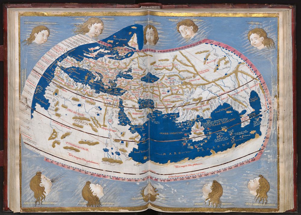
Maps, manuscripts, and Mediterranean memory.
Posts Media Videos Starter Packs
Pinned
Cristoforo Buondelmonti: Florentine priest, humanist, traveler, and pioneer of island cartography in the early 15th century.
This is a space for historical geography, manuscripts, codices, and maps, images, archival notes, and materials from his own works. You are welcome to connect.
Map of Constantinople by Cristoforo Buondelmonti in Liber insularum Archipelagi. Düsseldorf, Universitäts- und Landesbibliothek. Copy of Düsseldorf (1485–1490). The city (from Wikipedia the Free Encyclopedia).
A map of Constantinople by Cristoforo Buondelmonti in Liber insularum Archipelagi. Düsseldorf, Universitäts- und Landesbibliothek. Düsseldorf copy (1485–1490).🌠
Cristoforo Buondelmonti, Liber Insularum Archipelagi (1422), Ios Island, Aegean Sea.
Florence - Laurentian Library, Plut. 29. 25 (planisphere by Enrico Martello, ca. 1488), ff. 66v-67r
Biblioteca Medicea Laurenziana, Plut. 30. 4, cc. 76v-77r (Tolomeo - Geografia - Spagna)
The Geography (Γεωγραφικὴ Ὑφήγησις, Geōgraphikḕ Hyphḗgēsis, lit. "Geographical Guidance"), also known by its Latin names as the Geographia and the Cosmographia, is a gazetteer, an atlas, and a treatise on cartography, compiling the geographical knowledge of the 2nd-century Roman Empire.
Vatican Apostolic Library, Vatican lat. 5699 (Piero del Massaio, ca. 1450), ff. 120v-121r
Cristoforo Buondelmonti, Liber Insularum Archipelagi (1420), Milos island, Aegean Sea.
(Extracts from Wikipedia, the free encyclopedia)
Reposted by Cristoforo Buondelmonti – Maps & Cartography
When snails ruled the earth.......

BL Add MS 49622, f.162v
Reposted by Cristoforo Buondelmonti – Maps & Cartography
Cristoforo Buondelmonti, Liber Insularum Archipelagi (1420), Island of Rhodes, Aegean Sea.
Reposted by Cristoforo Buondelmonti – Maps & Cartography
Cristoforo Buondelmonti’s 1422 map of Constantinople — transmitted in several manuscript copies now held in European libraries — is the only pre-conquest depiction of the city that can be regarded as faithful to reality. (From Wikipedia, the free encyclopedia)
Buondelmonti's map of Constantinople from 1422, the only one preceding the Ottoman conquest of 1453.