


Atlas Guo
@cartoguophy.bsky.social
A Map Evangelist
CartoGuophy.com
CartoGuophy.com
Pinned
Atlas Guo
@cartoguophy.bsky.social
· Oct 24


🌎I’m actively seeking full-time roles as a #Cartographer (on-site / remote). With rich experience in cartography & GIS, my work has been widely recognized with 70+ achievements (CartoGuophy.com). If your team’s hiring or you know openings, I’d truly appreciate any referrals or shares! #OpenToWork
#30DayMapChallenge | Day 6 Dimensions |
I colored my #lasercut #Wisconsin 3D #topographic map. Though the natural HDF wood tone limited the choice of colors, the dark edges did enhance the 3D effect. Watercolor was used to fill up the valleys. (The digital file was shared to local blind school.)
I colored my #lasercut #Wisconsin 3D #topographic map. Though the natural HDF wood tone limited the choice of colors, the dark edges did enhance the 3D effect. Watercolor was used to fill up the valleys. (The digital file was shared to local blind school.)


December 13, 2025 at 5:33 PM
#30DayMapChallenge | Day 6 Dimensions |
I colored my #lasercut #Wisconsin 3D #topographic map. Though the natural HDF wood tone limited the choice of colors, the dark edges did enhance the 3D effect. Watercolor was used to fill up the valleys. (The digital file was shared to local blind school.)
I colored my #lasercut #Wisconsin 3D #topographic map. Though the natural HDF wood tone limited the choice of colors, the dark edges did enhance the 3D effect. Watercolor was used to fill up the valleys. (The digital file was shared to local blind school.)
#30DayMapChallenge | Day 21 Icons | This prompt reminds me of the #LEGO #AppleMaps icon I created this summer, which displays Apple Park at Cupertino. Recently, I experimented with another major competitor, #GoogleMaps, though sadly its icon is not a map.


December 11, 2025 at 4:12 PM
#30DayMapChallenge | Day 21 Icons | This prompt reminds me of the #LEGO #AppleMaps icon I created this summer, which displays Apple Park at Cupertino. Recently, I experimented with another major competitor, #GoogleMaps, though sadly its icon is not a map.
#30DayMapChallenge | Day 22 Natural Earth
Based on my earlier #chromostereopsis globe, I made another #stereogram centered on the Western Hemisphere. Use the magic-eye parallel view at phone-screen size to see the 3D effect. It can be very tough, so don't force it since it may strain your eyes🫨
Based on my earlier #chromostereopsis globe, I made another #stereogram centered on the Western Hemisphere. Use the magic-eye parallel view at phone-screen size to see the 3D effect. It can be very tough, so don't force it since it may strain your eyes🫨

December 10, 2025 at 6:08 AM
#30DayMapChallenge | Day 22 Natural Earth
Based on my earlier #chromostereopsis globe, I made another #stereogram centered on the Western Hemisphere. Use the magic-eye parallel view at phone-screen size to see the 3D effect. It can be very tough, so don't force it since it may strain your eyes🫨
Based on my earlier #chromostereopsis globe, I made another #stereogram centered on the Western Hemisphere. Use the magic-eye parallel view at phone-screen size to see the 3D effect. It can be very tough, so don't force it since it may strain your eyes🫨
#30DayMapChallenge | Day 23 Process | #Procreate #DigitalWatercolor #Taiwan Island
My first iPad painting! Still struggling with the Apple Pencil, but it was really fun with only a bit of real #watercolor experience. I exported a GIF of all my layers, even though I really didn’t need that many.
My first iPad painting! Still struggling with the Apple Pencil, but it was really fun with only a bit of real #watercolor experience. I exported a GIF of all my layers, even though I really didn’t need that many.
December 9, 2025 at 3:38 AM
#30DayMapChallenge | Day 23 Process | #Procreate #DigitalWatercolor #Taiwan Island
My first iPad painting! Still struggling with the Apple Pencil, but it was really fun with only a bit of real #watercolor experience. I exported a GIF of all my layers, even though I really didn’t need that many.
My first iPad painting! Still struggling with the Apple Pencil, but it was really fun with only a bit of real #watercolor experience. I exported a GIF of all my layers, even though I really didn’t need that many.
#30DayMapChallenge | Day 19 Projections & 22 Natural Earth | I created a fun “shaking” earth graphic based on #chromostereopsis, a color-based depth illusion in which red and blue light fall on slightly different spots in the eyes, creating a horizontal offset that our brain interprets as depth.🌐👀

December 7, 2025 at 4:54 AM
#30DayMapChallenge | Day 19 Projections & 22 Natural Earth | I created a fun “shaking” earth graphic based on #chromostereopsis, a color-based depth illusion in which red and blue light fall on slightly different spots in the eyes, creating a horizontal offset that our brain interprets as depth.🌐👀
#30DayMapChallenge | Day 25 Hexagons | My multivariate map tile for 2025 @NACIS #MapQuilt visualizes the risk of 18 natural hazards in southern #Louisville. Each 200-acre hexagon’s score is aggregated from #FEMA NRI at the census-tract level. More info: cartoguophy.com/maps/multiha....


December 6, 2025 at 9:02 PM
#30DayMapChallenge | Day 25 Hexagons | My multivariate map tile for 2025 @NACIS #MapQuilt visualizes the risk of 18 natural hazards in southern #Louisville. Each 200-acre hexagon’s score is aggregated from #FEMA NRI at the census-tract level. More info: cartoguophy.com/maps/multiha....
#30DayMapChallenge | Day 20 Water | #LEGO #Bathymetric Map of #GreatLakes. Visualizing 3D #bathymetry is much harder than the terrain, and I tested a lot of versions before choosing this style. I also tried some new designs for the map frame, north arrow, and legend. Feedback welcomed! #cartography

December 6, 2025 at 7:04 PM
#30DayMapChallenge | Day 20 Water | #LEGO #Bathymetric Map of #GreatLakes. Visualizing 3D #bathymetry is much harder than the terrain, and I tested a lot of versions before choosing this style. I also tried some new designs for the map frame, north arrow, and legend. Feedback welcomed! #cartography
I was delighted to introduce cartography to students from Central Gwinnett High School at City of #Lawrenceville #GISDay, using my LEGO maps to share the joy of mapmaking. It was my first time speaking to younger audiences. I hope the experience sparked their curiosity about geography and maps.✨


December 5, 2025 at 11:27 PM
I was delighted to introduce cartography to students from Central Gwinnett High School at City of #Lawrenceville #GISDay, using my LEGO maps to share the joy of mapmaking. It was my first time speaking to younger audiences. I hope the experience sparked their curiosity about geography and maps.✨
#30DayMapChallenge | Day 27 Boundaries | A virtually rendered #LEGO map of the #BritishIsles, with each area in its own color and elevation shown by stacked plates. I also added an inset map for the first time, following the terrain style from my well-received #Arizona map.


December 4, 2025 at 4:25 AM
#30DayMapChallenge | Day 27 Boundaries | A virtually rendered #LEGO map of the #BritishIsles, with each area in its own color and elevation shown by stacked plates. I also added an inset map for the first time, following the terrain style from my well-received #Arizona map.
#30DayMapChallenge | Day 24 Places and their Names | Latest map for public history project #Shanghai Dérive 魔都漂移 #CityWalk. This chapter traces the “Lone Island” in years 1937–1941, revisiting key resistance plates through on-site walks. More details: mp.weixin.qq.com/s/I09Hb52YtA....


December 3, 2025 at 4:52 AM
#30DayMapChallenge | Day 24 Places and their Names | Latest map for public history project #Shanghai Dérive 魔都漂移 #CityWalk. This chapter traces the “Lone Island” in years 1937–1941, revisiting key resistance plates through on-site walks. More details: mp.weixin.qq.com/s/I09Hb52YtA....
#30DayMapChallenge | Day 15 Fire | This is a fire in the literal sense. The 43-hour blaze in #HongKong was a true disaster, and I created a map to document it. The style sits between a rapid-response news map and a detailed event map, in both English and Traditional Chinese. Pray for all affected.🕯️

December 2, 2025 at 11:55 AM
#30DayMapChallenge | Day 15 Fire | This is a fire in the literal sense. The 43-hour blaze in #HongKong was a true disaster, and I created a map to document it. The style sits between a rapid-response news map and a detailed event map, in both English and Traditional Chinese. Pray for all affected.🕯️
#30DayMapChallenge | Day 28 Black | I painted the #hillshade around #SanFrancisco using black #watercolor. After adding some light colors for land and sea, it looked like an old map, which was really fun. Then I wrote some place names in a vintage type style to match this style.

November 28, 2025 at 11:21 PM
#30DayMapChallenge | Day 28 Black | I painted the #hillshade around #SanFrancisco using black #watercolor. After adding some light colors for land and sea, it looked like an old map, which was really fun. Then I wrote some place names in a vintage type style to match this style.
#30DayMapChallenge | Day 17 A New Tool |
AI-generated “ancient style” map of Madison using #NanoBanana Pro🍌. Still has typos and shaky lines, but already far better than early AI maps. #AI is moving from pure inspiration toward practical cartographic tool. The Age of AI has begun~
AI-generated “ancient style” map of Madison using #NanoBanana Pro🍌. Still has typos and shaky lines, but already far better than early AI maps. #AI is moving from pure inspiration toward practical cartographic tool. The Age of AI has begun~

November 25, 2025 at 6:55 PM
#30DayMapChallenge | Day 17 A New Tool |
AI-generated “ancient style” map of Madison using #NanoBanana Pro🍌. Still has typos and shaky lines, but already far better than early AI maps. #AI is moving from pure inspiration toward practical cartographic tool. The Age of AI has begun~
AI-generated “ancient style” map of Madison using #NanoBanana Pro🍌. Still has typos and shaky lines, but already far better than early AI maps. #AI is moving from pure inspiration toward practical cartographic tool. The Age of AI has begun~
Proudly showcasing my LEGO and natural disaster maps at the #UGA #GISDay, where I also served as a map poster judge. I was one of the student organizers (Chair of Logistic Committee) in the 1st campus-wide UGA GIS Day, and it's a true honor to return as an alumnus and witness its ten-year milestone!


November 20, 2025 at 4:55 AM
Proudly showcasing my LEGO and natural disaster maps at the #UGA #GISDay, where I also served as a map poster judge. I was one of the student organizers (Chair of Logistic Committee) in the 1st campus-wide UGA GIS Day, and it's a true honor to return as an alumnus and witness its ten-year milestone!
#30DayMapChallenge | Day 13 10-minute map | Tiny #LEGO #Georgia Map
I didn’t have my LEGO elements with me, so I used whatever pieces I had to build a tiny Georgia map. It’s probably the least geometrically/topologically accurate LEGO map, but it's still a strong candidate for the cutest one. 😅🍑
I didn’t have my LEGO elements with me, so I used whatever pieces I had to build a tiny Georgia map. It’s probably the least geometrically/topologically accurate LEGO map, but it's still a strong candidate for the cutest one. 😅🍑

November 16, 2025 at 5:35 AM
#30DayMapChallenge | Day 13 10-minute map | Tiny #LEGO #Georgia Map
I didn’t have my LEGO elements with me, so I used whatever pieces I had to build a tiny Georgia map. It’s probably the least geometrically/topologically accurate LEGO map, but it's still a strong candidate for the cutest one. 😅🍑
I didn’t have my LEGO elements with me, so I used whatever pieces I had to build a tiny Georgia map. It’s probably the least geometrically/topologically accurate LEGO map, but it's still a strong candidate for the cutest one. 😅🍑
Had a wonderful day at Cobb County (GA) #GISDay sharing my #LEGO maps and U.S. #NaturalHazard visualizations. I truly enjoyed the conversations and loved seeing people discover info or fun moments through the maps. Huge thanks to the organizers for the invite and the great event today! 🗺️✨


November 15, 2025 at 4:22 AM
Had a wonderful day at Cobb County (GA) #GISDay sharing my #LEGO maps and U.S. #NaturalHazard visualizations. I truly enjoyed the conversations and loved seeing people discover info or fun moments through the maps. Huge thanks to the organizers for the invite and the great event today! 🗺️✨
#30DayMapChallenge | Day 12 Map from 2125 | TBD
Imagining a map 100 years ahead is tough. I’ve got ideas to share later, just not today. For now, here’s a map I made last year for 100th anniversary of my alma mater, Sun Yat-sen University #SYSU on Nov 12, birthday of Dr. #SunYatSen, father of ROC.
Imagining a map 100 years ahead is tough. I’ve got ideas to share later, just not today. For now, here’s a map I made last year for 100th anniversary of my alma mater, Sun Yat-sen University #SYSU on Nov 12, birthday of Dr. #SunYatSen, father of ROC.


November 13, 2025 at 12:39 PM
#30DayMapChallenge | Day 12 Map from 2125 | TBD
Imagining a map 100 years ahead is tough. I’ve got ideas to share later, just not today. For now, here’s a map I made last year for 100th anniversary of my alma mater, Sun Yat-sen University #SYSU on Nov 12, birthday of Dr. #SunYatSen, father of ROC.
Imagining a map 100 years ahead is tough. I’ve got ideas to share later, just not today. For now, here’s a map I made last year for 100th anniversary of my alma mater, Sun Yat-sen University #SYSU on Nov 12, birthday of Dr. #SunYatSen, father of ROC.
This Friday 11/14, I will be attending Georgia's Cobb County GIS Day event with a booth sharing many physical and digital LEGO maps (similar to but more than this photo), several U.S. natural disaster map posters, and FREE LEGO map stickers! Looking forward to the event!😉


November 13, 2025 at 4:57 AM
This Friday 11/14, I will be attending Georgia's Cobb County GIS Day event with a booth sharing many physical and digital LEGO maps (similar to but more than this photo), several U.S. natural disaster map posters, and FREE LEGO map stickers! Looking forward to the event!😉
#30DayMapChallenge | Day 8 Urban | This is an HDF laser-cut 3D #Madison city flag, which also reads as a city map, including the two lakes and an isthmus land, with a four-wing capitol building at center. I gave it a watercolor coat and made it as a magnet. What a little Madison souvenir!


November 12, 2025 at 5:48 PM
#30DayMapChallenge | Day 8 Urban | This is an HDF laser-cut 3D #Madison city flag, which also reads as a city map, including the two lakes and an isthmus land, with a four-wing capitol building at center. I gave it a watercolor coat and made it as a magnet. What a little Madison souvenir!
#30DayMapChallenge | Day 11 Minimal Map | I turned my Day 3 recolored AI-generated low-poly map of the contiguous US into a simple #watercolor painting. It's fun when a rough handmade meets futuristic low poly, but staying faithful to satellite imagery terrain colors instead of AIGC made-up details.

November 11, 2025 at 12:28 AM
#30DayMapChallenge | Day 11 Minimal Map | I turned my Day 3 recolored AI-generated low-poly map of the contiguous US into a simple #watercolor painting. It's fun when a rough handmade meets futuristic low poly, but staying faithful to satellite imagery terrain colors instead of AIGC made-up details.
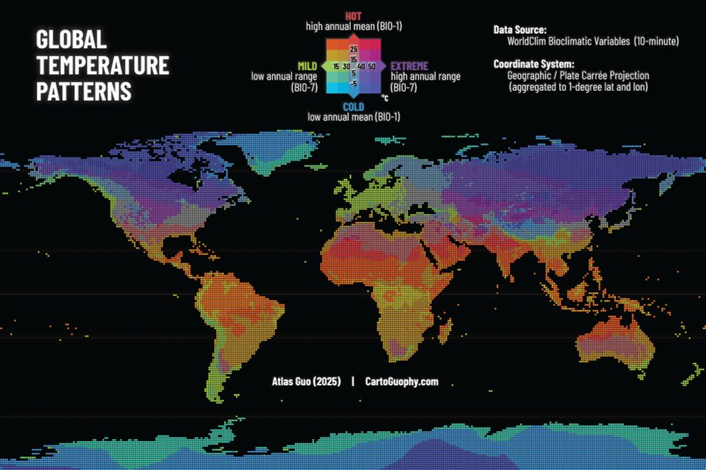
#30DayMapChallenge | Day 10 Air | This is an exploratory bivariate map illustrating global temperature patterns based on WorldClim bioclimatic variables: annual mean temperature (BIO-1) and annual temperature range (BIO-7). Read more: cartoguophy.com/maps/global_...
November 10, 2025 at 3:42 PM
#30DayMapChallenge | Day 10 Air | This is an exploratory bivariate map illustrating global temperature patterns based on WorldClim bioclimatic variables: annual mean temperature (BIO-1) and annual temperature range (BIO-7). Read more: cartoguophy.com/maps/global_...
#30DayMapChallenge Day 9 Analog | I’m an amateur Irish tin/low whistle player. I previously made two tiny #Ireland #LEGO maps with 30×30 km cells and 75 m per vertical brick. I gave one away to MUSO, my Madison Irish music session, and keep the other with me for attending LEGO community events.☘️🪈


November 10, 2025 at 4:54 AM
#30DayMapChallenge Day 9 Analog | I’m an amateur Irish tin/low whistle player. I previously made two tiny #Ireland #LEGO maps with 30×30 km cells and 75 m per vertical brick. I gave one away to MUSO, my Madison Irish music session, and keep the other with me for attending LEGO community events.☘️🪈
#30DayMapChallenge Day 7 Accessibility & 8 Urban | #Atlanta #Metro (#Marta) Map | It's challenging to represent linear features using LEGO, due to its low resolution and limited angular flexibility. This map illustrating Atlanta’s MARTA lines and I-285 shows the potential of this mapping approach.🚊🏙

November 9, 2025 at 9:08 PM
#30DayMapChallenge Day 7 Accessibility & 8 Urban | #Atlanta #Metro (#Marta) Map | It's challenging to represent linear features using LEGO, due to its low resolution and limited angular flexibility. This map illustrating Atlanta’s MARTA lines and I-285 shows the potential of this mapping approach.🚊🏙
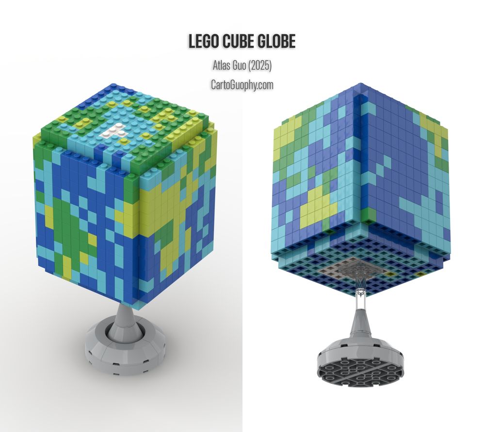
#30DayMapChallenge Day 5&6 I just completed my first #globe design, a virtually rendered #LEGO cube globe! The colors were derived from a pixelated Natural Earth raster layer (Cube Projection). As usual, I applied manual cartographic curation to preserve recognizable geography. Hope you enjoy it!
November 9, 2025 at 5:00 AM
#30DayMapChallenge Day 5&6 I just completed my first #globe design, a virtually rendered #LEGO cube globe! The colors were derived from a pixelated Natural Earth raster layer (Cube Projection). As usual, I applied manual cartographic curation to preserve recognizable geography. Hope you enjoy it!
#30DayMapChallenge Day 4: My Data. I spent a special summer interning at #Apple Maps—my first time in the #BayArea and first time exploring a place ( #Cupertino) entirely by #bike. I meant to just map my rides, but ended up refining many details (still ongoing) as it was such a rewarding experience!

November 8, 2025 at 5:37 AM
#30DayMapChallenge Day 4: My Data. I spent a special summer interning at #Apple Maps—my first time in the #BayArea and first time exploring a place ( #Cupertino) entirely by #bike. I meant to just map my rides, but ended up refining many details (still ongoing) as it was such a rewarding experience!