


Civixplorer
@civixplorer.bsky.social
𝐓𝐡𝐞 𝐞𝐲𝐞 𝐨𝐟 𝐭𝐡𝐞 𝐰𝐨𝐫𝐥𝐝.
🔎 Keep exploring → www.taplink.cc/civixplorer
🗺️ Get your 3D relief map (𝟭𝟬% 𝗼𝗳𝗳) → www.3dmap.cc/coupon_civixplorer
🔎 Keep exploring → www.taplink.cc/civixplorer
🗺️ Get your 3D relief map (𝟭𝟬% 𝗼𝗳𝗳) → www.3dmap.cc/coupon_civixplorer
Pinned
Civixplorer
@civixplorer.bsky.social
· Sep 27
Transform your space with stunning 3D relief maps!
🛒 Shop now: 3dmap.cc
✨ Code 'CIVIXPLORER' for 10% off!
🛒 Shop now: 3dmap.cc
✨ Code 'CIVIXPLORER' for 10% off!
Latin American presidents of Arab descent.
🔎 The World in Maps
🔎 The World in Maps

December 7, 2025 at 7:11 PM
Latin American presidents of Arab descent.
🔎 The World in Maps
🔎 The World in Maps
❤️🤍 A selection of red and white flags in a horizontal bicolor pattern.

December 7, 2025 at 5:11 PM
❤️🤍 A selection of red and white flags in a horizontal bicolor pattern.
🚗 Did you know Ferrari, Lamborghini and Maserati HQs all sit within ~25 km of each other?

December 7, 2025 at 3:07 PM
🚗 Did you know Ferrari, Lamborghini and Maserati HQs all sit within ~25 km of each other?
What if the Isle of Man became the Isle of Woman?

December 7, 2025 at 1:16 PM
What if the Isle of Man became the Isle of Woman?
Which European country makes the best sausages?

December 7, 2025 at 10:27 AM
Which European country makes the best sausages?
What if European states were Nordic?

December 7, 2025 at 7:12 AM
What if European states were Nordic?
India 🇮🇳 vs 🇨🇳 China — the projected working age populations.
🔎 Visual Capitalist
🔎 Visual Capitalist

December 7, 2025 at 4:20 AM
India 🇮🇳 vs 🇨🇳 China — the projected working age populations.
🔎 Visual Capitalist
🔎 Visual Capitalist
👥 Post-pandemic population change by U.S. county (2021-2024).

December 7, 2025 at 1:08 AM
👥 Post-pandemic population change by U.S. county (2021-2024).
Shadow of the Moon seen from the ISS during the total solar eclipse of 2024.

December 6, 2025 at 10:07 PM
Shadow of the Moon seen from the ISS during the total solar eclipse of 2024.
My brain refuses to accept this map.
Rome is actually north of NYC, and Milan shares a latitude with Montreal.
Rome is actually north of NYC, and Milan shares a latitude with Montreal.

December 6, 2025 at 7:07 PM
My brain refuses to accept this map.
Rome is actually north of NYC, and Milan shares a latitude with Montreal.
Rome is actually north of NYC, and Milan shares a latitude with Montreal.
🥘 The 100 best cuisines in the world 25/26, by TasteAtlas.
What are your thoughts?
What are your thoughts?

December 6, 2025 at 5:06 PM
🥘 The 100 best cuisines in the world 25/26, by TasteAtlas.
What are your thoughts?
What are your thoughts?
The most common surname in each canton of Switzerland 🇨🇭
A reflection of its multiculturalism.
A reflection of its multiculturalism.

December 6, 2025 at 3:07 PM
The most common surname in each canton of Switzerland 🇨🇭
A reflection of its multiculturalism.
A reflection of its multiculturalism.
⚽️🏆 The smallest nations to ever qualify for the FIFA World Cup.
🔎 geomapasgr
🔎 geomapasgr

December 6, 2025 at 1:07 PM
⚽️🏆 The smallest nations to ever qualify for the FIFA World Cup.
🔎 geomapasgr
🔎 geomapasgr
💸 How do you say "corruption" in your country? In mine, we call it "administrative fees."
🔎 Amazing Maps
🔎 Amazing Maps

December 6, 2025 at 10:08 AM
💸 How do you say "corruption" in your country? In mine, we call it "administrative fees."
🔎 Amazing Maps
🔎 Amazing Maps
👨🏻🎓 Which EU country leads in education spending?
🔎 European Magazine
🔎 European Magazine

December 6, 2025 at 7:12 AM
👨🏻🎓 Which EU country leads in education spending?
🔎 European Magazine
🔎 European Magazine
👥 Population density of South Asia and Myanmar.
🔎 Python Maps
🔎 Python Maps

December 6, 2025 at 4:18 AM
👥 Population density of South Asia and Myanmar.
🔎 Python Maps
🔎 Python Maps
Where each U.S. state's largest immigrant population was born.

December 6, 2025 at 1:07 AM
Where each U.S. state's largest immigrant population was born.
💻 The world's top digital exporters by value of delivered services.

December 5, 2025 at 10:08 PM
💻 The world's top digital exporters by value of delivered services.
North America if all the ice melted.

December 5, 2025 at 7:09 PM
North America if all the ice melted.
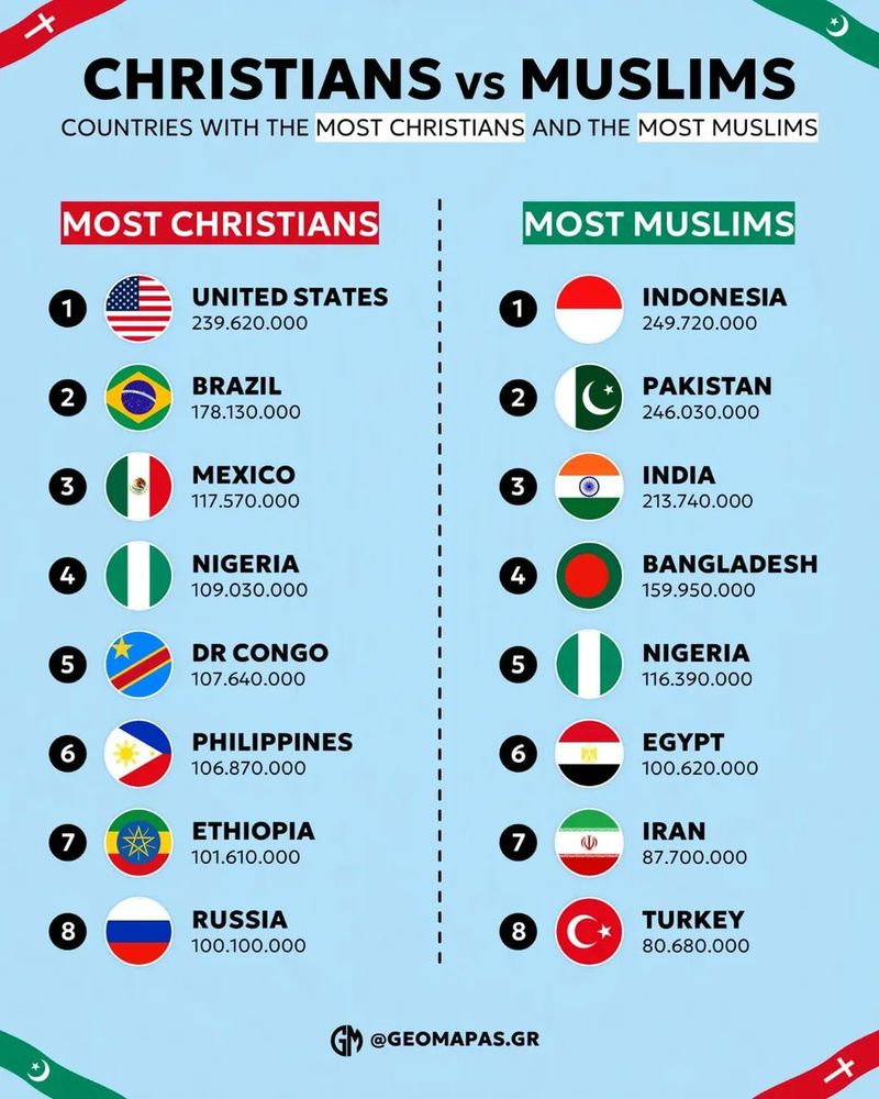
Christians 🆚 Muslims — comparing the countries with the most followers by religion.
December 5, 2025 at 5:07 PM
Christians 🆚 Muslims — comparing the countries with the most followers by religion.
🌲 Types of forests in the world.
🔎 Visual Capitalist
🔎 Visual Capitalist

December 5, 2025 at 3:08 PM
🌲 Types of forests in the world.
🔎 Visual Capitalist
🔎 Visual Capitalist
Comparing the highest and lowest military spenders by % of GDP.

December 5, 2025 at 1:07 PM
Comparing the highest and lowest military spenders by % of GDP.
⚔️ Fall or conquest of Constantinople?
This map shows how the major languages of different countries title their Wikipedia page on the event.
This map shows how the major languages of different countries title their Wikipedia page on the event.

December 5, 2025 at 10:11 AM
⚔️ Fall or conquest of Constantinople?
This map shows how the major languages of different countries title their Wikipedia page on the event.
This map shows how the major languages of different countries title their Wikipedia page on the event.
🇳🇦 Namibia, where the desert meets the ocean.

December 5, 2025 at 7:11 AM
🇳🇦 Namibia, where the desert meets the ocean.
Relief map of the Indian subcontinent and the Himalayas.

December 5, 2025 at 4:16 AM
Relief map of the Indian subcontinent and the Himalayas.