Cumberland Valley Weather Group
@cumberlandvalleywx.bsky.social
110 followers 280 following 600 posts
We are a group of weather enthusiasts who like to share weather data amongst ourselves and with both Jackson & Louisville KY NWS offices. Why not join us and #ShareYourWeather! #ekywx #kywx
Posts Media Videos Starter Packs
Reposted by Cumberland Valley Weather Group
cocorahskyjc6.bsky.social
Daily @cocorahskyjc6.bsky.social report for 23 July 2025 to #nwsjacksonky for #ekywx #kywx #DanielBooneNF and #kymesonet using #Logia7in1WiFi #PWS and #CoCoRaHS-approved Rain gauge. This station's #wxdata can be found at wunderground.com/pws/dashboard/KKYMCKEE41 #ShareYourWeather #BeWeatherAware
Reposted by Cumberland Valley Weather Group
cocorahskyjc6.bsky.social
Heat advisory will be in effect for locations west of I-65 on Wed. afternoon with the rest of us experiencing heat index values near or over 100°F across much Central Kentucky and Southern Indiana. Complete forecast: weather.gov/louisville #kywx #inwx #BeWeatherAware
Reposted by Cumberland Valley Weather Group
cocorahskyjc6.bsky.social
Hot and humid conditions Wed.-Fri., brings a heightened threat of heat impacts for those who are heat-sensitive in East Kentucky. Temperatures in the upper 80s to low 90s, and dew points in the low 70s will create heat indices approaching 100°F across much of the area. #kywx #ekywx #BeWeatherAware
Reposted by Cumberland Valley Weather Group
cocorahskyjc6.bsky.social
@sdf.nws-bot.us Louisville KY NWS Office #LMK continues a Heat Advisory. It will be valid at Jul 23, 1:00 PM EDT for portions of Indiana and north central, northwest, and south central Kentucky till Jul 23, 8:00 PM EDT #kywx #inwx mesonet.agron.iastate.edu/vtec/?year=2...
KLMK Heat Advisory #3
Dubois, Perry, Hancock, Breckinridge, Ohio, Grayson, Butler, Edmonson, Logan, Warren, Simpson, Allen
mesonet.agron.iastate.edu
Reposted by Cumberland Valley Weather Group
cocorahskyjc6.bsky.social
@wpc.weather.im issues an updated Day 3-7 Hazards Outlook on July 22, 3:53 PM EDT. Heavy rain and hazardous heat are the main threats for the Ohio River Valley. www.wpc.ncep.noaa.gov/threats/thre... #ekywx #JKL #kywx #inwx #LMK
cumberlandvalleywx.bsky.social
Thanksgiving has made its way into our forecast! Check out the latest forecast each day as any travel plans approach, to help you plan accordingly. Be sure you know what’s ahead so you and your family arrive safely. weather.gov #kywx #usawx
cumberlandvalleywx.bsky.social
An early-season snowstorm impacted the central Appalachians to the Northeast over the last few days last week. While KY received less than 12", snowfall totals of 1 to 2 feet occurred across the higher elevations of WV, MD, PA, NY, & north NJ. Below is a summary of select local storm reports. #usawx
cumberlandvalleywx.bsky.social
Milder temps return to Eastern Kentucky through Monday before rain arrives Monday evening departing early Tuesday. Most areas will see 0.1"-0.2", with locally heavier amounts possible in persistent bands. The next round of rain occurs later in the week, centered around Thanksgiving. #kywx #ekywx
cumberlandvalleywx.bsky.social
Enjoy the sunshine across Central KY & So. IN. today. Tomorrow will be mild, with rain chances esp. in the afternoon as a cold front approaches. If you're making plans for Thanksgiving, rain chances arrive Wednesday, and Thanksgiving will have cold rain and breezy conditions. #kywx #inwx
Reposted by Cumberland Valley Weather Group
cocorahskyjc6.bsky.social
@cocorahskyjc6.bsky.social weather conditions at the 8h on 24 November 2024, including this location's two-day hyper-local forecast for 24-25 November 2024 from the Jackson KY NWS office. All this current data plus yesterday's (23 November) PWS summary are all given ⬇️. #ekywx #kywx #ShareYourWeather
cumberlandvalleywx.bsky.social
Dry and seasonably cool temperatures will continue for the weekend across Central KY and Southern IN. Looking ahead: the weather on travel day, Wednesday, will be mostly cloudy with a shower or two, then the holiday itself looks gray and rainy. #lmkwx #kywx #inwx #BePrepared #StayWeatherAware
Reposted by Cumberland Valley Weather Group
cocorahskyjc6.bsky.social
@cocorahskyjc6.bsky.social weather
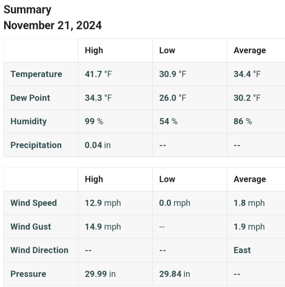
conditions at the 8h on 22 Nov. 2024, incl. 1.13" of Snow & the two-day hyper-local forecast for 22-23 Nov. 2024 from the Jackson KY NWS office. All this current data plus yesterday's (21 Nov.) PWS summary are all given ⬇️. #ekywx #kywx #ShareYourWeather
cumberlandvalleywx.bsky.social
Observed snowfall analysis ending this morning, 11/22/2024. #ekywx #kywx #inwx
cumberlandvalleywx.bsky.social
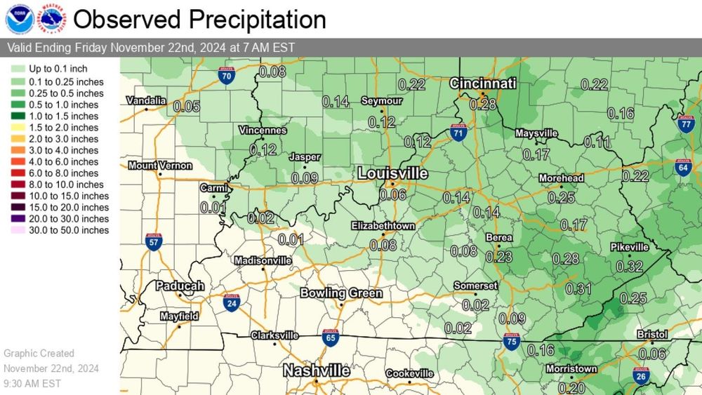
24 Hour Precipitation Ending 7AM Fri Nov 22, 2024. Scattered rain and snow showers across southern Indiana and much of central to eastern KY. #ekywx #kywx #inwx
cumberlandvalleywx.bsky.social
Cloudy, cool and breezy today across Central Kentucky and Southern Indiana. #kywx #inwx
cumberlandvalleywx.bsky.social
As the current weather system tapers off Eastern Kentucky, a look ahead shows a brief reprieve in active weather through most of Monday, with precipitation chances returning again towards the Thanksgiving Holiday period. Stay tuned for more details. #kywx #ekywx
Reposted by Cumberland Valley Weather Group
cocorahskyjc6.bsky.social
@cocorahskyjc6.bsky.social weather conditions at the 0h on 22 November 2024, with 0.75" snow measured and yesterday's (21 Nov.) PWS summary are all given ⬇️. #ShareYourWeather with @nwsjacksonky #ekywx #kywx
cumberlandvalleywx.bsky.social
A Winter Weather Advisory is still in effect until 7 AM. Snow should come to an end near or after dawn tomorrow, but wind chills are expected to be quite chilly tomorrow morning! For more details, go to: weather.gov/media/jkl/DssPacket.pdf #ekywx #kywx
cumberlandvalleywx.bsky.social
As temperatures continue to drop off after sunset, our first measurable snow of the season is ongoing! Steadier snow has started across the Bluegrass, and some terrain enhancement is visible in the East Kentucky mountains. Most accumulation will be on elevated and grassy surfaces. #ekywx #kywx
cumberlandvalleywx.bsky.social
Light to moderate snowfall continues this evening and tonight with minor accumulations mostly in grassy areas and elevated surfaces. A Winter Weather Advisory is still in effect for portions of central Kentucky and southern Indiana. #kywx #inwx
cumberlandvalleywx.bsky.social
The Jackson KY NWS office (JKL) issues the latest Hazardous Weather Outlook at 327PM EST on 21 November 2024, and continues the Winter Weather Advisory for portions of Eastern Kentucky valid until Nov 22, 7:00 AM EST. #ekywx #kywx
cumberlandvalleywx.bsky.social
The Louisville NWS office (LMK) continues the Winter Weather Advisory for portions of Central Kentucky and for Jefferson County, IN valid at Nov 21, 4:00 PM EST till Nov 22, 7:00 AM EST #kywx #inwx
cumberlandvalleywx.bsky.social
Steadier snow will move in quickly into Eastern Kentucky from the northwest this evening. Initially, this will accumulate on grassy and elevated surfaces. #kywx #ekywx