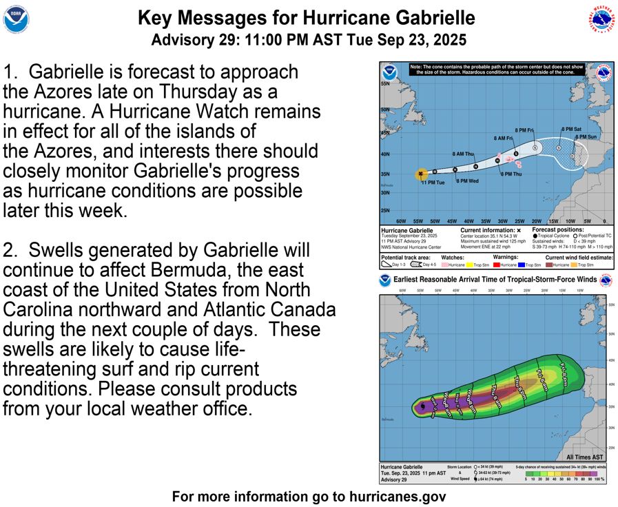
Etienne Kapikian
@ekmeteo.bsky.social
480 followers 180 following 22 posts
Prévisionniste cyclone à Météo-France Océan Indien - Tropical cyclone forecaster at RSMC La Reunion. #meteo #climat
Posts Media Videos Starter Packs
ekmeteo.bsky.social
Chaleur tardive exceptionnelle en Asie de l'Est incluant le sud du #Japon où des records mensuels d'octobre sont battus chaque jour sur des stations anciennes (cf tableau JMA).
🌡️35.0°C ce 12/10 à Kimotsuki Maeda : 35°C les plus tardifs jamais mesurés au Japon (ancien : 35.1°C Itoigawa 9/10/2013)
...
Reposted by Etienne Kapikian
copernicusecmwf.bsky.social
🌡️ The September 2025 #C3S Climate Bulletin reports the third-warmest September globally, with an average surface air temperature of 16.11°C — 1.47°C above estimated pre-industrial levels. Global average sea surface temperature reached 20.72°C, the 3rd-highest on record for September.
Reposted by Etienne Kapikian
stabilizclimate.bsky.social
🥵🌉MONTHLY NATIONAL RECORD for OCTOBER for the HIGHEST DAILY MINIMUM TEMPERATURE in #JAPAN🇯🇵 on 4 October 2025 : the Tmin from midnight to midnight was 🌡️28.9°C in #Ishigakijima Island (#Okinawa).
Previous record : 28.6°C, 7-10-2019, Minamitorishima Island.
www.data.jma.go.jp/stats/etrn/v...
Reposted by Etienne Kapikian
metoffice.gov.uk
Storm Amy has been record breaking ⚠️

An air pressure of 947.9 hPa was recorded at Baltasound, Shetland, provisionally setting a new UK lowest pressure record for October.

Northern Ireland provisionally recorded its strongest October wind gust on record, with a gust of 92 mph at Magilligan.
ekmeteo.bsky.social
🌀L'ouragan #Humberto s'intensifiant en catégorie 5 ce samedi 27/09 au soir.
cira-csu.bsky.social
An absolutely stunning view today of Hurricane Humberto, a Category 5 storm.
ekmeteo.bsky.social
🌀L'ouragan majeur #HUMBERTO a temporairement atteint samedi 27/09 au soir la catégorie 5 sur l'échelle de Saffir-Simpson (vents 1-min de 140 kt). Ce dimanche matin, il retrouve le haut de la catégorie 4 (135 kt) sur une trajectoire restant à l'écart des terres habitées.
www.nhc.noaa.gov
Reposted by Etienne Kapikian
extremetemps.bsky.social
EXTRAORDINARY
National monthly record broken also in Central African Republic with 37.0C at Bangui

Hundreds of thousands of square km with record heat allover the area in CAF,both Congos,Gabon,Angola
Absolutely historic and unprecedented event.
African climatic history rewritten
Reposted by Etienne Kapikian
extremetemps.bsky.social
EXCEPTIONAL HEAT WAVE IN CENTRAL AFRICA
Dozens of September Records smashed with huge margins all accross the area

CONGO KINSHASA 35.8 Kinshasa
CENTRAL AFRICAN REPUBLIC 37.0 Bangui
CONGO BRAZZAVILLE: 36 Brazzaville, 35 34.5 Mouyondzi 500m asl
and Dozens more..
ekmeteo.bsky.social
Les 10.6°C de maxi à Reims-Prunay (station actuelle) ce 24/09 sont aussi plus bas que le record mensuel de Txn de l'ancienne station Reims-Courcy, ouverte en 1929 (10.8°C le 16/09/1986).
ekmeteo.bsky.social
Un 24 septembre remarquablement frais sur l'Hexagone. A #Paris Montsouris par exemple, la température maximale quotidienne est de seulement 10.9°C (valeur définitive), la plus basse en septembre depuis les 10.3°C du 16/09/1986 (le record étant de 9.9°C le 28/09/1919).
francoisjobard.bsky.social
🌡️🥶Avec seulement 10,8 °C au plus chaud de la journée au parc Montsouris à #Paris, la capitale vient de connaître son jour de septembre le plus froid depuis 1986 (10,3 °C le 16 septembre 1986).
maximale la plus basse en septembre à Paris Montsouris depuis 1900
Reposted by Etienne Kapikian
cira-csu.bsky.social
Hurricane Gabrielle hurries eastward across the Atlantic Ocean.

A hurricane warning is currently in effect for all of the islands of the Azores.
Reposted by Etienne Kapikian
nhc-atlc.nws-bot.us
Atlantic Hurricane Gabrielle Advisory Number 30 issued at Wed, 24 Sep 2025 08:33:32 +0000
...HURRICANE WARNING ISSUED FOR THE AZORES... ...GABRIELLE CONTINUES MOVING QUICKLY EAST-NORTHEASTWARD ACROSS THE NORTH ATLANTIC...
Additional Details Here.

        000WTNT32 KNHC 240833TCPAT2 BULLETINHurricane Gabrielle Advisory Number  30NWS National Hurricane Center Miami FL       AL072025500 AM AST Wed Sep 24 2025 ...HURRICANE WARNING ISSUED FOR THE AZORES......GABRIELLE CONTINUES MOVING QUICKLY EAST-NORTHEASTWARD ACROSS THENORTH ATLANTIC...  SUMMARY OF 500 AM AST...0900 UTC...INFORMATION----------------------------------------------LOCATION...35.6N 51.5WABOUT 1360 MI...2190 KM W OF THE AZORESMAXIMUM SUSTAINED WINDS...115 MPH...185 KM/HPRESENT MOVEMENT...ENE OR 75 DEGREES AT 25 MPH...41 KM/HMINIMUM CENTRAL PRESSURE...959 MB...28.32 INCHES  WATCHES AND WARNINGS--------------------CHANGES WITH THIS ADVISORY: The Meteorological Service of Portugal has issued a HurricaneWarning for the Azores. SUMMARY OF WATCHES AND WARNINGS IN EFFECT: A Hurricane Warning is in effect for...* All of the Azores A Hurricane Warning means that hurricane conditions are expectedsomewhere within the warning area.  A warning is typically issued36 hours before the anticipated first occurrence oftropical-storm-force winds, conditions that make outsidepreparations difficult or dangerous.  Preparations to protect lifeand property should be rushed to completion. For storm information specific to your area, please monitorproducts issued by your national meteorological service.  DISCUSSION AND OUTLOOK----------------------At 500 AM AST (0900 UTC), the center of Hurricane Gabrielle waslocated near latitude 35.6 North, longitude 51.5 West. Gabrielle ismoving toward the east-northeast near 25 mph (41 km/h), and thismotion with some additional acceleration is expected to continuefor the next several days.  On the forecast track, the center ofGabrielle will approach the Azores during the day on Thursday, andmove across the island chain Thursday night into Friday. Maximum sustained winds are near 115 mph (185 km/h) with highergusts.  Gabrielle is a category 3 hurricane on the Saffir-SimpsonHurricane Wind Scale.  Steady weakening is expected during thenext couple of days, but Gabrielle is still expected to be ahurricane when it passes through the Azores. Hurricane-force winds extend outward up to 45 miles (75 km) from thecenter and tropical-storm-force winds extend outward up to 140 miles(220 km). The estimated minimum central pressure is 959 mb (28.32 inches).  HAZARDS AFFECTING LAND----------------------Key messages for Gabrielle can be found in the Tropical CycloneDiscussion under AWIPS header MIATCDAT2 and WMO header WTNT42 KNHC. WIND: Hurricane conditions are expected in the warning areaThursday night and Friday. STORM SURGE:  A dangerous storm surge is expected to producesignificant coastal flooding near the areas of onshore winds. Thesurge will be accompanied by large and destructive waves. RAINFALL: From Thursday into Friday morning, Gabrielle may bring 3to 5 inches, or 75 to 125 mm, of rainfall across the central andwestern Azores. During the same time outer bands from Gabrielle mayalso result in 1 to 2 inches, or 25 to 50 mm, of rain across theeastern Azores. SURF: Swells generated by Gabrielle will continue to affect Bermuda,the U.S. East Coast from North Carolina northward, and AtlanticCanada over the next few days. These swells are expected to producelife-threatening surf and rip current conditions. Please consultproducts issued by your local weather office.  NEXT ADVISORY-------------Next intermediate advisory at 800 AM AST.Next complete advisory at 1100 AM AST. $$Forecaster Beven
      Hurricane Gabrielle 5-Day Uncertainty Track Image Hurricane Gabrielle 34-Knot Wind Speed Probabilities
Reposted by Etienne Kapikian
nhc-atlantic.extwitter.link
11 PM AST - 9/23/25: Here are the Key Messages for Hurricane #Gabrielle - A Hurricane Watch remains in effect for the Azores. Catch the latest at http://hurricanes.gov https://pbs.twimg.com/media/G1lHg_-XYAAM-oL.png
ekmeteo.bsky.social
🌀Activitié cyclonique très précoce pour l'hiver austral sur le Sud-Ouest de l'océan Indien : Tempête tropicale #BLOSSOM baptisée dans la nuit du mercredi 10 au jeudi 11 septembre (cf burst convectif + oeil en 37GHz). C'est déjà la 2e de la saison après AWO début août !
meteofrance.re/fr/cyclone
ekmeteo.bsky.social
🌡️Août 2025 : 3e mois d'août le plus chaud depuis le début des mesures sur le globe, 0.22°C derrière août 2024 & 2023 (les 3 derniers mois d'août sont les +chauds) : +0.49°C /moy1991-2020, +1.29°C /ère-préindus, selon #C3S
3e rang aussi pour le trimestre JJA 2025
climate.copernicus.eu/surface-air-...
Reposted by Etienne Kapikian
bmcnoldy.bsky.social
Sept 2:
Today is the 90th anniversary of the most intense landfalling hurricane in U.S. history: the 1935 Labor Day Hurricane. Peak sustained winds were 185 mph when it tore through the Florida Keys. And like the other U.S. Category 5 landfalls, it was only a tropical storm three days prior.
[1/2]
ekmeteo.bsky.social
La liste de tous les records mensuels battus ces 1er et 2 septembre est bien trop longue pour être citée. En voici quelques autres :

le 1er/09
38.2°C Nagoya
37.4 Nara
37.2 Okayama (le 1er et 2/09)
37.2 Ueno
36.8 Tsuruga
36.5 Osaka
33.0 Cap Irouzaki

le 2/09
36.9 Mito
35.2 Ofunato
34.7 Shirakawa
etc
Reposted by Etienne Kapikian
meteofrance.com
🔴 [Bilan été]

3ᵉ été le plus chaud depuis 1900 avec 2 épisodes caniculaires, 27 jours en vague de chaleur.

Les températures maximales au-dessus des normales 2 jours sur 3

Le seuil des 35 °C atteint sur plus de 80 % du territoire et celui des 40 °C sur plus de 20 %

meteofrance.com/actualites-e...
ekmeteo.bsky.social
Dans la continuité d'un été record, le #Japon continue de battre de nombreux records mensuels de chaleur ce début septembre, incluant stations anciennes :
🌡️39.8°C Hatoyama ce 2/09, 3e +haute T° jamais mesurée au Japon en septembre
38.4 Maebashi
38.1 Toyooka
37.4 Sendai, RECORD ABSOLU->37.3 1/08/2018
Le Japon est entouré d'eaux exceptionnellement chaudes suite à cet été record, qui entretiennent à leur tour des masses d'air anormalement chaudes en ce début d'automne météo. L'été météorologique 2025 (juin-juillet-août) est de loin le plus chaud depuis le début des mesures au Japon, avec une anomalie de +2.36°C battant de 0.6°C les précédents étés les plus chauds (2023 et 2024).
Reposted by Etienne Kapikian
metoffice.gov.uk
Met Office stats confirm summer 2025 is officially the warmest summer on record for the UK.

The UK’s mean temp of 16.10°C surpasses the previous record of  15.76°C and pushes the summer of 1976 out of the top 5 warmest summers.

www.metoffice.gov.uk/about-us/new...
Summer 2025 is the warmest on record for the UK
Provisional Met Office statistics confirm that summer 2025 is officially the warmest summer on record for the UK.
www.metoffice.gov.uk
Reposted by Etienne Kapikian
extremetemps.bsky.social
HISTORIC 2025 SUMMER IN CHINA & JAPAN
HOTTEST SUMMER IN HISTORY

Last 4 summers are the 4 hottest !

Japan summer a whopping +2.36C vs 1991/2020
China +1.08C

Both Koreas also had their hottest summer on record.

Kudos:JMA,Jim Jiang and KMA
Reposted by Etienne Kapikian
gaetanheymes.bsky.social
Il est tombé 119 mm pour la journée climatologique du 27 août 2025 sur la station de Vichy Charmeil, ouverte en 1941.
C'est un nouveau record absolu, le précédent était de 80 mm le 24 juillet 1989.
Un peu plus au sud la station Infoclimat de Chaptuzat a observé 180 mm en 24 heures.
Carte du cumul de précipitations en 24h du 27 août 08h au 28 août 08h, centrée sur l'Auvergne.
Reposted by Etienne Kapikian
bmcnoldy.bsky.social
20 years ago today: #Katrina was a monster Category 5 hurricane over the Gulf of Mexico with maximum sustained winds of 150kts (173mph) and a 902mb central pressure. By this point, the aftermath was already very well predicted...
[1/4]
Reposted by Etienne Kapikian
afp.com
🌡️ Rares voire rarissimes en France au XXe siècle, les températures dépassant localement les 40 degrés sont devenues fréquentes depuis l’an 2000. Voici une carte animée localisant chaque année où les stations de Météo-France ont relevé ou dépassé 40 degrés (données au 17 août).
Reposted by Etienne Kapikian
cira-csu.bsky.social
On August 23, 2025, Tropical Storm Kajiki formed in the South China Sea and within the next 24 hours, it had strengthened into a typhoon. The storm made landfall in Vietnam earlier today.