Elizabeth Wig
@elizabethwig.bsky.social
590 followers 110 following 22 posts
InSAR & radar remote sensing 🛰 EE PhD candidate at Stanford 🌲 I like books, nature, and space 📚
Posts Media Videos Starter Packs
Reposted by Elizabeth Wig
leah-clayton.bsky.social
joining bluesky 🦋 | scientist + artist who thinks a lot about the intersection between the geophysical and ecological, climate futures, and resilience
A photograph of Lake Tahoe with a bright blue sky and a large tree in the center. A small inset of a black and white linocut print of the photograph.
elizabethwig.bsky.social
Permafrost is important for so many reasons – it's a natural carbon reservoir, the base for infrastructure, and a home to many species. Understanding how it's changing and the downstream effects of these changes is so important for making good decisions about all these things!
elizabethwig.bsky.social
Greening trends appear associated with smaller seasonal subsidence, thinner active layers, and wetter soil:
elizabethwig.bsky.social
Burned areas have higher soil water content than unburned areas:
elizabethwig.bsky.social
Lower soil moisture (volumetric water content) is associated with deeper active layers, suggesting that Arctic soil may become drier as the climate warms:
elizabethwig.bsky.social
This data set measures subsidence, soil moisture, and active layer thickness of #permafrost at millions of points. This allows us to investigate what processes and relationships from smaller-scale studies hold over larger regions. What do we discover? ⤵️
Map showing swaths included in the Permafrost Dynamics Observatory's ABoVE: Active Layer Thickness from Airborne L- and P- band SAR, Alaska, 2017
Reposted by Elizabeth Wig
scrippsocean.bsky.social
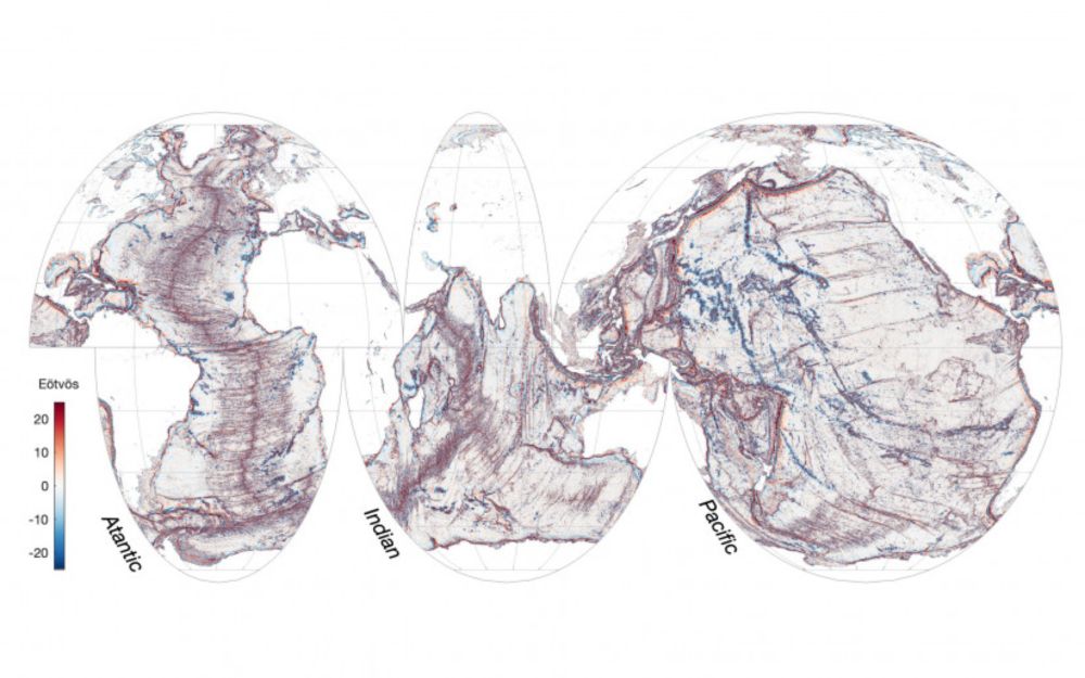
A satellite-mounted instrument has in just one year produced higher-resolution imagery of the global seafloor than that from comparable systems over the past 30 years. 'Sea' for yourself and learn more about the new study led by Scripps Oceanography postdoctoral scholar Yao Yu. ⬇️
SWOT Sharpens Seafloor Focus
A satellite-mounted instrument has in just one year produced higher-resolution imagery of the global seafloor than that from comparable systems over the past 30 years.
scripps.ucsd.edu
Reposted by Elizabeth Wig
elizabetheiden.bsky.social
At #AGU24? Interested in volcanoes? Interested in Venus? Come chat with me at my poster this afternoon! Poster number 3121
Scientific poster titled “Quantifying volcanism on Venus with VenSAR: Comparison with Earth and Suggestions for Targeted Observations”
elizabethwig.bsky.social
Happy #AGU24! If you're interested in learning about how InSAR closure phase can be used to measure moisture in soil, vegetation, or wildfire fuel materials, check out my poster Wednesday morning and talk Wednesday evening!
Remotely Sensed Fuel Moisture from InSAR Closure Phase on UAVSAR
Elizabeth Wig et al,  Hall B-C (Poster Hall) (Convention Center)
Wednesday, 11 December 2024 : 08:30 - 12:20

InSAR Closure Phase for Fine-Resolution Measurements of Changing Soil and Vegetation Moisture, Elizabeth Wig et al,     Marquis 1-2 (Marriott Marquis), Wednesday, 11 December 2024 : 17:00 - 17:10
elizabethwig.bsky.social
Everything going according to plan in the Sentinel-1C launch so far... excited and hopeful for more InSAR data to come!

Streaming right now at www.esa.int/ESA_Multimed...
Image of rocket moving through sky from livestream of Sentinel-1C satellite launch
elizabethwig.bsky.social
Would love to join this community! :)
elizabethwig.bsky.social
Interested in joining too, thanks for organizing!
elizabethwig.bsky.social
I hope you'll check our paper out if you have any interest in SAR, InSAR, or remote sensing of soil moisture or vegetation -- and please let me know if you have any questions 😊
elizabethwig.bsky.social
We also show that systematic bias in the closure phase can be caused by asymmetries in the time series, where wetting and drying happen at different rates. A more asymmetric time series (wetting is much faster or slower than drying) tends to produce a more "biased" time series.
elizabethwig.bsky.social
Estimation of soil moisture is poorer over crop land, likely because of changing vegetation. We characterize the accuracy of our estimate across different land cover types.
elizabethwig.bsky.social
We show that cumulative InSAR closure phase can be used to estimate soil moisture at 37 sites, validating with in situ measurements in Oklahoma. The estimates can be quite accurate!
elizabethwig.bsky.social
We use a model and real data to show that, because closure phase relates to *changes* in scattering properties, you can *cumulatively sum* a closure phase time series -- as a new way to measure soil moisture!
elizabethwig.bsky.social
InSAR closure phase is the result of combining radar signals from satellite overpasses from 3 different times. It's particularly sensitive to changing scattering properties on the ground, such as changes in soil moisture.
elizabethwig.bsky.social
My first first-author paper is finally published! 🥳🛰️
"Fine-Resolution Measurement of Soil Moisture from Cumulative InSAR Closure Phase"
This is the cumulative work of the 1st half of my PhD, and I'm so excited to be able to share the final product! 😄
bit.ly/closuresoil
Fine-Resolution Measurement of Soil Moisture From Cumulative InSAR Closure Phase
Soil moisture can vary spatially at the scale of agricultural fields (~10–100 m), which is generally too fine to resolve using passive radiometric methods. Active radar provides an opportunity for fin...
bit.ly
elizabethwig.bsky.social
Going to IEEE #IGARSS2024?

Come say hi - and check out my presentation on measuring changes in vegetation moisture from InSAR closure phase! Tuesday, 11:40 in the Student Paper Competition session 😎🛰🌲
elizabethwig.bsky.social
If you use SBAS or distributed scatterer time series for InSAR, you may be unknowingly aliasing your data! A new paper by my labmate Karissa Pepin explores how aliasing sneaks into InSAR time series & how to tailor temporal baselines to minimize this effect: bit.ly/aliasinsar
Aliasing in InSAR 2-D Phase Unwrapping and Time Series
We quantify and characterize an often-overlooked error source in interferometric synthetic aperture radar (InSAR) and derived time series: aliasing from insufficiently sampled interferograms in space ...
bit.ly
elizabethwig.bsky.social
…Or to come to watch me present, also tomorrow (Tues) 9:10-9:20 a.m., on what the results from the @ABoVE Permafrost Dynamics Observatory can tell us about the dynamic active layer soil moisture, and greening and browning
B21D-05 Results from the ABoVE Permafrost Dynamics Observatory: What Remote Sensing Big Data Tells Us about the Dynamic Active Layer, Soil Moisture, and Greening and Browning. Elizabeth Wig. 3006 - West (Level 3, West, MC)
elizabethwig.bsky.social
AGU23 has me wishing I could split myself in half!
 
Tomorrow (Tues) from 9:10-9:20 a.m., I encourage you to watch my advisor discuss our work on modelling InSAR closure phase to measure high-resolution soil moisture…
G21A-05 InSAR and Fine-Resolution Measurement of Soil Moisture: An Interference Scattering Model for Nonzero Phase Closure. Howard Zebker. 158-South (Upper Mezzanine, South, MC)