


Dr. Rowena Lohman
@rowenalohman.bsky.social
InSAR! 🦇On my radar: Earthquakes, subsidence, land surface properties and change detection. 🏳️🌈 🏳️⚧️ 💛🤍💜🖤
Personal account
Personal account
Reposted by Dr. Rowena Lohman
Reposted by Dr. Rowena Lohman

Hi #planetaryScience folks, we have an open position for a *Professor in Planetary Sciences* at the Space Research & Planetary Sciences Division of the @unibe.ch.
Application deadline: *Jan 31, 2026*
Full ad: ohws.prospective.ch/public/v1/jo...
Reach out to me if you have any questions!
🧵 1/5
Application deadline: *Jan 31, 2026*
Full ad: ohws.prospective.ch/public/v1/jo...
Reach out to me if you have any questions!
🧵 1/5

Uni Bern: Professor in Planetary Sciences
The Division of Space Research and Planetary Sciences of the Physics Institute, University of Bern, Switzerland, invites applications for a full-time position as a Professor in Planetary Sciences.
ohws.prospective.ch
November 17, 2025 at 3:51 PM
Hi #planetaryScience folks, we have an open position for a *Professor in Planetary Sciences* at the Space Research & Planetary Sciences Division of the @unibe.ch.
Application deadline: *Jan 31, 2026*
Full ad: ohws.prospective.ch/public/v1/jo...
Reach out to me if you have any questions!
🧵 1/5
Application deadline: *Jan 31, 2026*
Full ad: ohws.prospective.ch/public/v1/jo...
Reach out to me if you have any questions!
🧵 1/5
Reposted by Dr. Rowena Lohman
Ok one more video. the most beautiful fluke I've seen. edited for EXTRA BEAUTY!!!
November 24, 2025 at 4:51 AM
Ok one more video. the most beautiful fluke I've seen. edited for EXTRA BEAUTY!!!
Reposted by Dr. Rowena Lohman

An eruption from the #HayliGubbi volcano in #Ethiopia resulted in a large ash cloud, visible here from space. 🌋
This impressive view was seen 36,000km above Earth by our Meteosat-12 satellite on 23 November at 13:40 UTC.
This impressive view was seen 36,000km above Earth by our Meteosat-12 satellite on 23 November at 13:40 UTC.

November 24, 2025 at 10:10 AM
An eruption from the #HayliGubbi volcano in #Ethiopia resulted in a large ash cloud, visible here from space. 🌋
This impressive view was seen 36,000km above Earth by our Meteosat-12 satellite on 23 November at 13:40 UTC.
This impressive view was seen 36,000km above Earth by our Meteosat-12 satellite on 23 November at 13:40 UTC.
Reposted by Dr. Rowena Lohman
An explosive #eruption of Hayli Gubbi #volcano, located SE of Erta'Ale in the Afar Rift (Ethiopia), began at ~08:30 UTC on Nov 23. Eruption onset was fortuitously captured by a @planet.com overpass at 08:31 UTC. Hayli Gubbi has no record of Holocene eruptions. Toulouse VAAC reporting ash to ~15 km.


November 23, 2025 at 5:23 PM
An explosive #eruption of Hayli Gubbi #volcano, located SE of Erta'Ale in the Afar Rift (Ethiopia), began at ~08:30 UTC on Nov 23. Eruption onset was fortuitously captured by a @planet.com overpass at 08:31 UTC. Hayli Gubbi has no record of Holocene eruptions. Toulouse VAAC reporting ash to ~15 km.
As a human, I enjoy these pictures (and those from others) so much.
As an InSAR researcher I would VERY MUCH APPRECIATE IT IF THE SUN WOULD CHILL OUT, OKAY???
As an InSAR researcher I would VERY MUCH APPRECIATE IT IF THE SUN WOULD CHILL OUT, OKAY???

White fringing in one and FAE's* in the other. Don't even bother speaking to me, I'm too busy being smug.
*Fragmented aurora-like emissions, the floating green spots in the middle that don't seem to be attached to anything
*Fragmented aurora-like emissions, the floating green spots in the middle that don't seem to be attached to anything


November 23, 2025 at 5:39 PM
As a human, I enjoy these pictures (and those from others) so much.
As an InSAR researcher I would VERY MUCH APPRECIATE IT IF THE SUN WOULD CHILL OUT, OKAY???
As an InSAR researcher I would VERY MUCH APPRECIATE IT IF THE SUN WOULD CHILL OUT, OKAY???
Reposted by Dr. Rowena Lohman
Waves coming off the basalt columns at Reynisfjara black sand beach. It's amazing that the camera technology is so good now that this was handheld at 1/8th second - the columns are sharp but I was able to capture the movement of the water too.
#CanonR6II #Iceland #Geology
#CanonR6II #Iceland #Geology

November 23, 2025 at 10:04 AM
Waves coming off the basalt columns at Reynisfjara black sand beach. It's amazing that the camera technology is so good now that this was handheld at 1/8th second - the columns are sharp but I was able to capture the movement of the water too.
#CanonR6II #Iceland #Geology
#CanonR6II #Iceland #Geology
Reposted by Dr. Rowena Lohman

Fascinating to see this 2025 two-tone dust plume over Libya — a rare case where winds lifted soils from two distinct regions, blending darker, moisture-rich dust with lighter sandy particles over the Med.
What makes it even more interesting? A nearly identical event happened before — in OCT 2007🧵1/3
What makes it even more interesting? A nearly identical event happened before — in OCT 2007🧵1/3


October 24, 2025 at 7:10 AM
Fascinating to see this 2025 two-tone dust plume over Libya — a rare case where winds lifted soils from two distinct regions, blending darker, moisture-rich dust with lighter sandy particles over the Med.
What makes it even more interesting? A nearly identical event happened before — in OCT 2007🧵1/3
What makes it even more interesting? A nearly identical event happened before — in OCT 2007🧵1/3
Reposted by Dr. Rowena Lohman

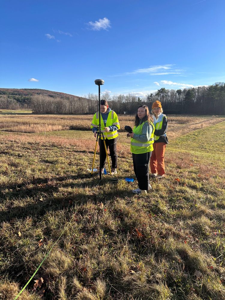
Beautiful November day for Field Geophysics looking for a buried gorge. Thanks to Geoff Abers for the photos.

November 20, 2025 at 1:10 PM
Beautiful November day for Field Geophysics looking for a buried gorge. Thanks to Geoff Abers for the photos.
Reposted by Dr. Rowena Lohman

Speaking of bad science in media (and I am using the term "media" pretty loosely here), allow me to use The Daily Mail as evidence of why you should get your science information from reputable agencies rather than crap websites. I'm not going to link the article, but it looks like this:
1/n
1/n

November 19, 2025 at 9:49 PM
Speaking of bad science in media (and I am using the term "media" pretty loosely here), allow me to use The Daily Mail as evidence of why you should get your science information from reputable agencies rather than crap websites. I'm not going to link the article, but it looks like this:
1/n
1/n
Reposted by Dr. Rowena Lohman

Treatment for trans kids cannot wait for adulthood. Adolescent changes in the body are permanent and irreversible. The pain of dysmorphia kills. No medical professional treats kids casually, no family seeks treatment casually. Treatment is safe, effective and is a conservative course of action.
November 19, 2025 at 4:33 PM
Treatment for trans kids cannot wait for adulthood. Adolescent changes in the body are permanent and irreversible. The pain of dysmorphia kills. No medical professional treats kids casually, no family seeks treatment casually. Treatment is safe, effective and is a conservative course of action.
Reposted by Dr. Rowena Lohman

parents freed a hummingbird from a skylight with a coleus flower attached to a pole
November 9, 2025 at 12:05 AM
parents freed a hummingbird from a skylight with a coleus flower attached to a pole
Reposted by Dr. Rowena Lohman

Fee-fi-fo-fum the Polar Vortex is about to come undone! 😳
That typically means wild weather/ big time cold to follow!
But wait, don’t head for the hills just yet. I assure you the sky won’t fall.
Seriously though, you’re bound to hear about this, and the science is fascinating, so let’s dig in… 1/
That typically means wild weather/ big time cold to follow!
But wait, don’t head for the hills just yet. I assure you the sky won’t fall.
Seriously though, you’re bound to hear about this, and the science is fascinating, so let’s dig in… 1/

November 18, 2025 at 12:13 AM
Fee-fi-fo-fum the Polar Vortex is about to come undone! 😳
That typically means wild weather/ big time cold to follow!
But wait, don’t head for the hills just yet. I assure you the sky won’t fall.
Seriously though, you’re bound to hear about this, and the science is fascinating, so let’s dig in… 1/
That typically means wild weather/ big time cold to follow!
But wait, don’t head for the hills just yet. I assure you the sky won’t fall.
Seriously though, you’re bound to hear about this, and the science is fascinating, so let’s dig in… 1/
Reposted by Dr. Rowena Lohman

New discovery in Otter Space

November 16, 2025 at 10:04 PM
New discovery in Otter Space
Reposted by Dr. Rowena Lohman

Some inspiring words on cinema in the streaming era from the Pope.
Yes, THAT Pope.
Yes, THAT Pope.

November 15, 2025 at 4:26 PM
Some inspiring words on cinema in the streaming era from the Pope.
Yes, THAT Pope.
Yes, THAT Pope.
Reposted by Dr. Rowena Lohman

Come be my colleague at University of Hawaiʻi at Mānoa. We're hiring an assistant professor in Ocean Biogeochemical Modeling. 🌊

Career Opportunities at the University of Hawai'i | University of Hawai'i
www.schooljobs.com
November 15, 2025 at 12:05 PM
Come be my colleague at University of Hawaiʻi at Mānoa. We're hiring an assistant professor in Ocean Biogeochemical Modeling. 🌊
Reposted by Dr. Rowena Lohman

Reposting this, because it's the best alt text I have ever written.

November 13, 2025 at 11:01 PM
Reposting this, because it's the best alt text I have ever written.
Reposted by Dr. Rowena Lohman

⚡️Solar storm incoming! We are actively monitoring severe space weather events, occurring on 11-12 November. Severely disturbed geomagnetic conditions are expected to persist for at least 24 to 48 hours.
🔗 www.esa.int/Space_Safety...
@operations.esa.int @science.esa.int
🔗 www.esa.int/Space_Safety...
@operations.esa.int @science.esa.int
November 12, 2025 at 3:48 PM
⚡️Solar storm incoming! We are actively monitoring severe space weather events, occurring on 11-12 November. Severely disturbed geomagnetic conditions are expected to persist for at least 24 to 48 hours.
🔗 www.esa.int/Space_Safety...
@operations.esa.int @science.esa.int
🔗 www.esa.int/Space_Safety...
@operations.esa.int @science.esa.int
Reposted by Dr. Rowena Lohman

It’s aurora time people. Get those cameras out

November 12, 2025 at 1:09 AM
It’s aurora time people. Get those cameras out
Reposted by Dr. Rowena Lohman
"In an internal memo from September, CEO Sam Altman said that OpenAI’s “audacious long-term goal is to build 250 gigawatts of capacity by 2033.” If Altman achieves this goal, OpenAI will need almost exactly as much electricity as India’s 1.5 billion people"
Great @truthdig.com piece on chips ->
Great @truthdig.com piece on chips ->

The Ecological Cost of AI Is Much Higher Than You Think - Truthdig
As the demands of AI grow, each generation of microchips requires more energy, minerals and water to produce, driving a ruinous cycle.
www.truthdig.com
November 11, 2025 at 1:47 PM
"In an internal memo from September, CEO Sam Altman said that OpenAI’s “audacious long-term goal is to build 250 gigawatts of capacity by 2033.” If Altman achieves this goal, OpenAI will need almost exactly as much electricity as India’s 1.5 billion people"
Great @truthdig.com piece on chips ->
Great @truthdig.com piece on chips ->
Reposted by Dr. Rowena Lohman

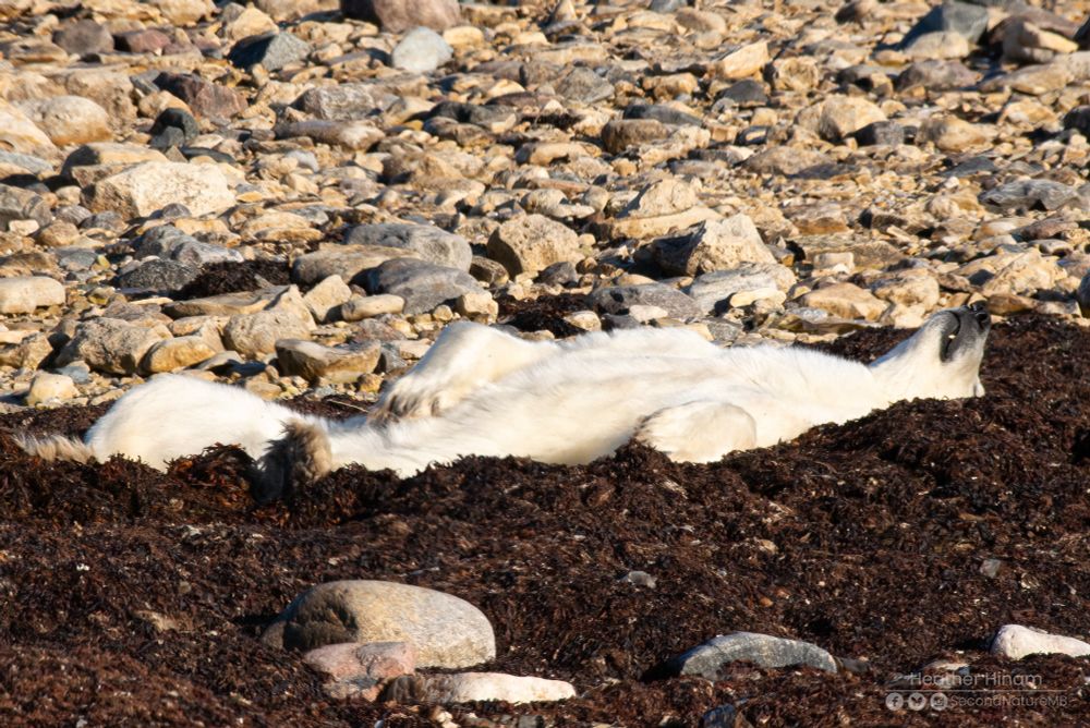
Polar bears are experts in relaxing. Nothing like a good kelp bed in the sunshine. #Mammals #BearSeason2025 🌿


November 11, 2025 at 2:23 AM
Polar bears are experts in relaxing. Nothing like a good kelp bed in the sunshine. #Mammals #BearSeason2025 🌿
Reposted by Dr. Rowena Lohman

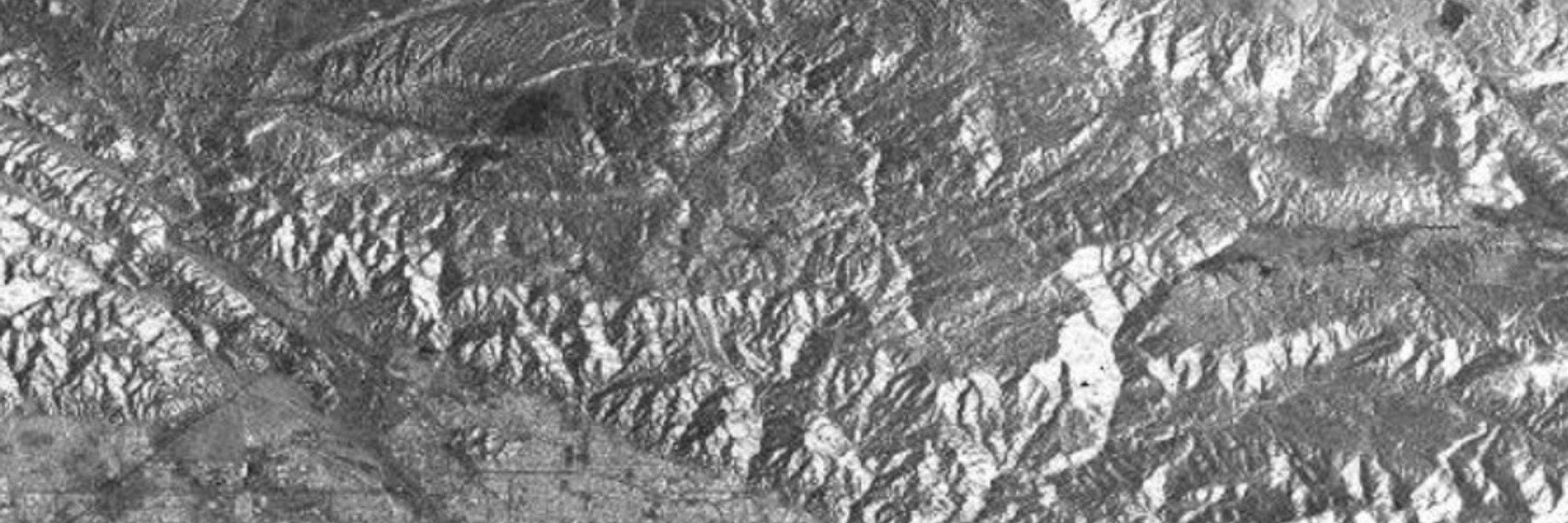
As a remote sensing geoscientist, I am often asked about satellite and other aerial images. So here's a primer:
Arial imagery vs Times New Roman imagery.
#dadjoke #EarthObservation
🧪⚒️🛰️
Arial imagery vs Times New Roman imagery.
#dadjoke #EarthObservation
🧪⚒️🛰️

November 10, 2025 at 5:16 PM
As a remote sensing geoscientist, I am often asked about satellite and other aerial images. So here's a primer:
Arial imagery vs Times New Roman imagery.
#dadjoke #EarthObservation
🧪⚒️🛰️
Arial imagery vs Times New Roman imagery.
#dadjoke #EarthObservation
🧪⚒️🛰️
Reposted by Dr. Rowena Lohman
Reposted by Dr. Rowena Lohman

Tonight was a very bad night.
November 10, 2025 at 3:09 AM
Tonight was a very bad night.
Reposted by Dr. Rowena Lohman

“I think it’s a terrible mistake,” Sen. Elizabeth Warren says of the deal. “People want us to stand and fight for health care, and that's what I believe.” (via Igor Bobic, HuffPo) x.com/igorbobic/st...
November 10, 2025 at 12:42 AM
“I think it’s a terrible mistake,” Sen. Elizabeth Warren says of the deal. “People want us to stand and fight for health care, and that's what I believe.” (via Igor Bobic, HuffPo) x.com/igorbobic/st...